Hope you enjoyed the record warmth today, because Mother Nature is going to quickly remind you that it is still February.

Unseasonably mild temperatures continued across the region on Saturday, with a few records set, but a cold front moved through around midday, and a stronger one will move through this evening, bringing an abrupt end to the mild weather. Temperatures will quickly drop tonight as the front pushes offshore, and on Sunday, most places will likely be in the 30s or even upper 20s during the daytime. That’s not the big story though.
A wave of low pressure will ride along the front on Sunday, passing south and east of the region. It will be close enough to produce some light snow and snow showers across parts of eastern Massachusetts and Rhode Island, possibly even into southern New Hampshire, during Sunday morning and early afternoon. Most of the snow will remain light, with accumulations of an inch or two possible, mainly from Boston southward. The story doesn’t end there. As the low passes by, winds will shift into the northeast, which will result in some ocean-effect snow across parts of Cape Cod and coastal Plymouth County, and possibly Cape Ann as well. The areas that receive snow will be highly dependent on the wind direction. Northeast winds will spread the snow inland across southeastern Massachusetts, but as winds shift into the north Sunday night, the bands of ocean-effect snow will retreat closer to the coast of Plymouth County and across Cape Cod. By Monday morning, winds will shift into the northwest, bringing an end to the snow for most of us.
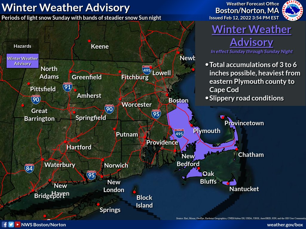
How much snow may fall? North and West of I-495, just a dusting to perhaps a half an inch. From 495 to I-95, some spots could see an inch, possibly 2 inches. It’s areas south of Boston (and Cape Ann), that may need shovels (and possibly plows). Across interior portions of southeastern Massachusetts as well as Cape Ann, we could see 2-4 inches of snow. The “jackpot” is likely to be across coastal Plymouth County as well as parts of Cape Cod, where as much as 4-7 inches could accumulate.

High pressure builds in behind this system on Monday with much colder weather. Despite sunshine developing in the afternoon, temperatures will only rise into the lower to middle 20s for highs, with single numbers and lower teens likely Monday night as skies clear out and winds die down. Tuesday also looks chilly, though likely a few degrees milder, but a big warmup is likely for the middle to latter half of the week. In fact, we could make a run at 60 again on Thursday, before another system brings in some rain.

There are some indications that this arctic blast for Monday and Tuesday could be the last really cold blast of the winter. Oh, it’ll still be cold, it’s only mid-February after all, but days with highs in the 20s and lows in the single numbers or below zero may be done for the year, though this is far from a guarantee. We’ve been known to have arctic blasts into March and even early April, though with the increasing sun angle, they tend to lose their staying power. This does not mean that winter is over, not by a longshot. We still can get snow around here well into April and even May if things set up properly. The longer range models are indicating that a milder pattern should start to take hold soon, and last into March. However, these same models also still show the threat for snow well into March, so don’t go putting away the winter gear just yet.
