Winter or Spring? It depends on your definition, as March could be either. In terms of the forecast for the next few days, we’ll have both.
For most people, spring (a.k.a. astronomical spring), begins with the vernal equinox, which takes place this year on Sunday March 20 at 11:33AM. For others, meteorological or climatological spring began on March 1. No matter which definition you use, it will feel like winter into Friday. High pressure builds in tonight, with clearing and very cold conditions. Temperatures will likely drop into the single numbers in some of the cold spots Friday morning. Friday will also be rather chilly despite ample sunshine. The high slides off to the east on Saturday as low pressure heads toward the Great Lakes. It will send a warm front toward our area. The front will be accompanied by plenty of clouds, and although temperatures will turn milder with the high sliding offshore, the real mild air won’t be here yet.
Saturday night, that warm front moves through with a few showers possible, but temperatures will rise overnight. Could be there a little freezing rain or sleet over the interior right at the start? Sure it’s possible, but right now, it looks like temperatures might be a tad too warm by the time any precipitation arrives. This sets up a Sunday that will definitely feel like spring, as gusty southwest winds send temperatures to near or even over 60 degrees across the area, except for the South Coast, where the wind off the still-chilly water will act as a seabreeze. What’s the catch? We’ll still have plenty of clouds along with some showers as low pressure passes north and west of the region.

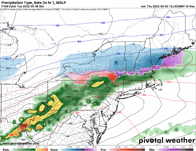
As the system moves by, it will try to drag a cold front across the area, but it doesn’t look like it will get all the way through. This has implications for Monday. Areas south of the front will stay quite mild Sunday night, while it will turn cooler north of the front. By Monday, another system quickly approaches from the southwest. This one looks a little more potent, but it will ride along that stalled out frontal boundary. Rain will redevelop in the afternoon, and it could be heavy in spots. North of the front, as colder air moves in, we could see a change to snow, especially Monday night into early Tuesday. We’ll look at this in much greater detail in our Weekly Outlook early Monday morning.
Thursday night: Clear and cold. Low 7-14.
Friday: Mostly sunny. High 28-35.
Friday night: Clear during the evening, some clouds start to filter in late at night. Low 13-20.
Saturday: Increasing and thickening clouds. High 36-43.
Saturday night: Mostly cloudy, chance for a few showers, possibly a little wintry mix well inland. Low 27-34 during the evening, temperatures rise overnight.
Sunday: Cloudy, windy, and mild with occasional showers. High 57-64, a little cooler along the South Coast.
Sunday night: Mostly cloudy. Low 40-47.
Monday: Cloudy with periods of rain or showers developing, possibly mixed with snow or sleet well inland by late in the day and at night. High 47-54, possibly cooler across southern New Hampshire and northern Massachusetts.
