While today is turning out to be a fantastic day across the region, significant changes are coming, and it won’t take long for them to happen.
A cold front is crossing the region this afternoon, which will bring an end to our record warmth. A few spots even managed to reach 70 today, but you can kiss the mild weather goodbye, as it won’t be back for a while. Temperatures quickly drop this evening and tonight as high pressure builds in, but clouds will start to stream back in on Thursday as low pressure heads toward the Ohio Valley. The system will then redevelop off the Mid-Atlantic coastline, and pass south of New England on Friday. As you’d expect with a system passing south of us in late February, this will produce snow for most of the area. The exact track of the system will determine how much snow we get (more on that in a bit).

We’ll see snow develop before daybreak on Friday, and it may fall heavy at times during the morning and afternoon. At the same time, warmer air will be trying to move in aloft, which would allow the snow to change to sleet and/or freezing rain from south to north during the late morning and early afternoon. At this point, the only places that are likely to get above freezing and change to plain rain will be along the South Coast and across the Cape and the Islands. The question now is, how far north does that change to sleet occur, since it will have a significant impact on the accumulation totals? Most of the models only bring the change as far north as the Mass Pike. However, there is at least one model that brings the changeover all the way northward into southern New Hampshire. This concerns us a little, and we’re going to hedge our bets against this in the snowfall forecast, as you’ll see below.

No matter how far north the changeover gets, as the system starts to pull away later on Friday, everything should change back to snow before winding down and ending in the evening. While this will likely impact the evening commute, the impact will be considerably less than what the morning commute experiences.
As for amounts, this is where things get tricky, since any mixing will cut down amounts significantly. There has been a trend in the models over the past 12 hours or so to shift the axis of heaviest snow into northern and central Massachusetts, with a bit less as you head into southern New Hampshire. Having said that, here’s our thinking as of now:
Cape Cod: 2-4″
South Coast: 3-6″
Southeastern MA/RI: 5-9″
Metro Boston/MetroWest/Merrimack Valley/North Shore: 6-12″
Central and Southern New Hampshire/NH Seacoast: 5-10″
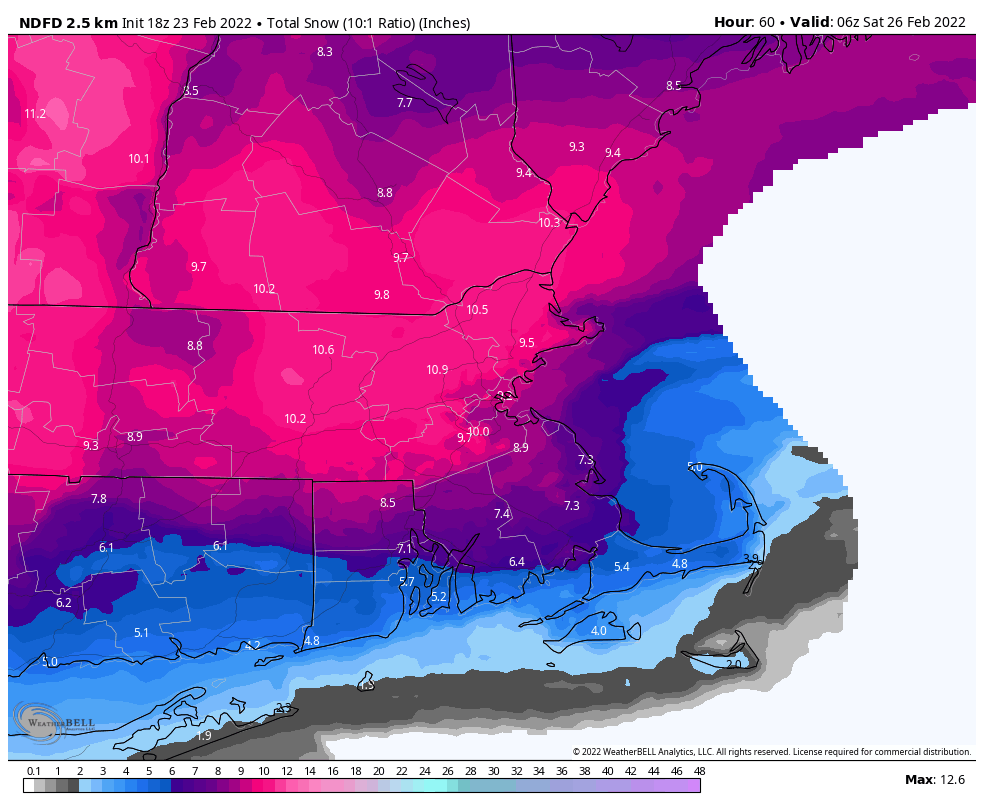
The ranges are a bit wider than we normally like, but this reflects the uncertainty. The less sleet that mixes in, the more likely you are to be near the higher end of the range. Conversely, the more sleet that mixes in, the more likely you are to be toward the lower end of the range. We’ll update this forecast in our Weekend Outlook tomorrow afternoon.
