Severe Weather in the South Today, but a Bigger Threat Looms for Friday

Severe weather is likely across portions of the Gulf Coast and Mississippi Valley today, but another, perhaps more widespread, outbreak is possible at the end of the week. While that is happening, a snowstorm might also be brewing in the Rockies. Spring can feature a little bit of everything across the nation.
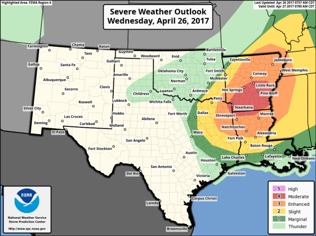
fema06_swody1
Severe weather is expected across portions of the Mississippi Valley today. Image provided by NOAA.

A strong cold front is moving into the Mississippi Valley and Texas this afternoon, and it is helping to trigger strong to severe thunderstorms across portions of the region. Ahead of the front, temperatures are into the 70s and lower 80s, with dewpoints in the upper 60s and 70s, so there’s plenty of warm, moist air in place. Behind the front, temperatures quickly drop into the 40s and 50s. Thunderstorms will continue to develop in the unstable airmass ahead of the front, with some of the storms containing large hail, heavy downpours, damaging winds, and possibly some tornadoes. Earlier this morning, some storms produced baseball-sized hail and wind gusts in excess of 70 mph in portions of Missouri, Arkansas, and Oklahoma. The threat should start to diminish across the region as we head into the overnight hours.


A more significant severe weather outbreak is possible later Friday into Saturday from the Southern Plains and Texas into portions of the Mississippi and Tennessee Valleys. Low pressure will move out of Texas and head northeastward, drawing warm, moist air northward from the Gulf of Mexico once again. North and west of the system, much cooler air will be in place (more on that in a moment).
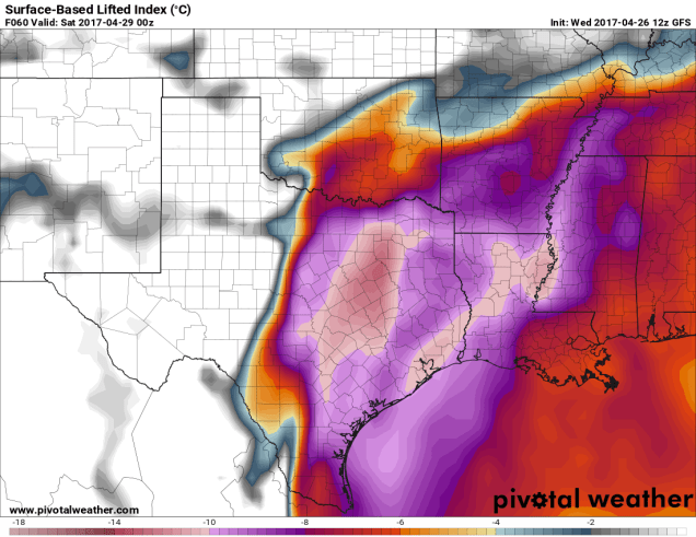
sbli.us_sc
Lifted index values of -10 and lower across Texas and the Lower Mississippi Valley show that the airmass will be very unstable on Friday. Image provided by Pivotal Weather.
sbcape.us_sc
CAPE values of 4000 J/kg and higher across Texas and the Lower Mississippi Valley show that the airmass will be very unstable on Friday. Image provided by Pivotal Weather.

As low pressure rides along the boundary between the two airmasses, it will help to trigger strong to severe thunderstorms across the region. The threat will continue into the overnight hours Friday night, shifting into the Mississippi and Tennessee Valleys on Saturday as the system continues to progress northeastward. Some of the storms may produce torrential downpours that could trigger flash flooding, large hail, damaging winds, and tornadoes.

gfs_tprecip_mc_21
The GFS model shows the potential for 5-10 inches of rain (or more) in parts of the Mississippi Valley through Sunday. Flooding is likely. Image provided by WeatherBell.

Behind the storm, as colder air settles into the region, a different threat is evolving – heavy snow. While it’s getting late in the season, heavy snow is not uncommon in the Central and Southern Rockies at this time of year. Some of the higher elevations in Colorado and New Mexico could receive 1-2 feet of snow Friday into Saturday. East of the Continental Divide, especially in the High Plains, snow is also possible, especially from eastern Colorado and western Kansas into portions of the Oklahoma and Texas Panhandles. In Denver, there is still a big question as to whether to precipitation falls mainly as rain, snow, or a wintry mix. Some snow accumulation seems likely at this point, but it’s still a little too early to tell whether there will be heavy snow in the city itself. The heavy snow threat will expand into the portions of the Upper Midwest and southern Canada Sunday into Monday as the storm moves into that region.

gfs_6hr_snow_acc_mc_21
GFS model forecast for snowfall in the Rockies and High Plains through Sunday. Winter is definitely not over there. Image provided by WeatherBell.

Severe weather outbreaks are not uncommon at this time of year. In fact, from late March into early May is when they are most likely. The largest tornado outbreak on record occurred 6 years ago this week. Between April 25 and 28, 2011, a total of 362 tornadoes were observed from Texas to New York and portions of southern Canada, resulting in 324 fatalities, 317 of them on April 27, the most active day.
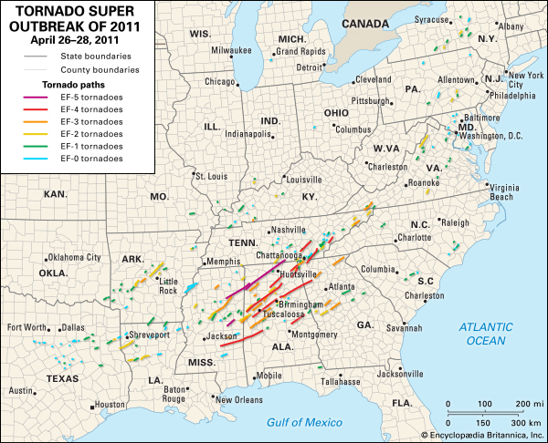
149638-004-5B45E68E
Map showing tracks of all 362 tornadoes from the April 2011 “Super Outbreak”. Image provided by Encyclopedia Brittanica.

As for our part of the country – the clouds and rain and cool temperatures will eventually move out. Things will start to improve on Thursday with some sunny breaks possible and temperatures into the 60s. By Friday, there will be more sunshine and temperatures getting into the 70s. Saturday looks like the best day, as temperatures could get into the lower 80s in some spots. We will have to watch out for some late-day showers and maybe a thunderstorm. Sunday looks to be significantly cooler thanks to a northeast wind off of the still-chilly Atlantic.

Weekly Outlook: April 24-May 1, 2017

Once again, we’ve got good news and bad news for the week ahead. The bad news is that the middle of the week will feature one, possibly two, absolutely miserable days. The good news? The end of the week will feature some fantastic weather. That makes us think of a certain move theme.

The week starts off with high pressure in control, giving us a fairly nice Monday, but things go downhill for Tuesday and Wednesday. Low pressure that is bringing very heavy rainfall to the Carolinas today will slowly move up the coastline. This will result in rain, gusty winds, and cool temperatures for Tuesday, likely lingering into Wednesday. In other words, typical springtime weather in New England. The system will depart on Thursday, then a south to southwesterly flow will develop across the area. This means warmer conditions are likely for Thursday and Friday. How warm? How does highs into the 70s, possibly 80s on Friday, sound? Yeah, we thought you might like that. A cold front approaches late Friday with some showers, but it may not move through until sometime on Saturday, resulting in another warm day. Much cooler conditions are expected on Sunday with more rain possible as a frontal system will be stalled out just south of the region.

qpf_acc.us_ne
Many locations could receive 1-2 inches of rain or more Tuesday into Wednesday. Image provided by Pivotal Weather.

Monday: Sunshine and some high clouds. High 57-64 along the coast, 65-72 inland.

Monday night: Becoming mostly cloudy, showers may develop towards daybreak. Low 39-46.

Tuesday: Breezy and cool with showers likely. High 44-51.

Tuesday night: Windy with showers becoming a steady rain, possibly heavy. Low 41-48 in the evening, then temperatures hold steady or rise a bit overnight.

Wednesday: Windy with showers gradually tapering off. High 55-62.

Thursday: Maybe a lingering shower early, otherwise clouds give way to some afternoon sunny breaks. High 65-72, cooler along the coast.

Friday: A mix of sun and clouds, chance for showers and maybe a thunderstorm late in the day. High 73-80, cooler along the coast.

Saturday: Sunshine fades behind increasing late-day clouds. Showers may develop at night. High 70-77.

Sunday:  Mostly cloudy with scattered showers possible. High 52-59 along the coast, 60-67 inland.

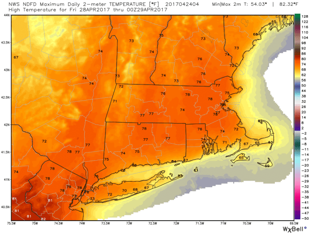
ndfd_t2max_massachusetts_5
Friday is looking like a fantastic day temperature-wise. Image provided by WeatherBell.

While we’re looking at some nice weather for the end of the week, a storm system will likely be making plenty of headlines in the nation’s midsection Friday and into next weekend. Severe weather may be fairly widespread ahead of the system from the Southern Plains and Texas into the Mississippi Valley, Gulf Coast, and Southeast. Behind the system, a late-season snowstorm is possible from the Rockies into the Northern Plains. It’s still several days away, but the mountains could pick up substantial amounts of snow from this storm, with heavy snow possible in places like Denver and Rapid City.

Weekly Outlook: April 17-23, 2017

We’ve made it to Patriots Day, a true “Boston Holiday”, and usually the final sign that winter is over and Spring has arrived. So, does that hold true this year? Probably.

baamarathon_2017_blast-header_725x355
Patriots Day is probably our favorite day of the year here at Storm HQ. Image provided by Boston Athletic Association.


As for the upcoming week, we’ve got good news and bad news. The good news is that Monday will be another fantastic day with partial sunshine and temperatures in the 60s to lower 70s. The bad news? Much of the rest of the week won’t be so nice. Let’s get to the details.

rtma_t2m_boston
Sunday was quite toasty across the region. Don’t expect a repeat this week, or for a while. Image provided by WeatherBell.

Monday starts off with low pressure head into the Atlantic Canada and high pressure starting to build in from the west and northwest. This will result in sunshine and gusty westerly winds.  Temperatures will still be on the warm side, but about 15-20 degrees cooler than they were on Sunday. By Tuesday, high pressure moves into Atlantic Canada, meaning we still have sunshine, but northeast to east winds off of the 45-degree Atlantic Ocean mean that temperatures will drop another 10-15 degrees or so. By Wednesday, winds shift back to the southwest. This is good, because we’ll turn warmer, right? Well, yes, it will be a little milder, but also a lot cloudier and probably wetter as some rain moves in. Another cold front will move through very slowly on Thursday, possibly stalling out across the region as another storm starts to move out of the Great Lakes. This means more rain for Thursday into Friday. Temperatures on Friday are a big question mark, especially south of the Mass Pike. It all depends on where the low pressure area actually tracks. If it stays south of New England as one models shows, temperatures may stay in the 40s all day. If it tracks along and/or north of the Mass Pike, as another model showers, temperatures could spike into the 60s and lower 70s south of the Pike while areas to the north stay in the upper 40s and 50s. For now, we’ll split the difference and go in the middle, but there is a large bust potential for that forecast. As the system moves offshore early Saturday, cooler air will settle in behind it. If the cooler air moves in overnight before the rain ends, we could see some wet snowflakes mix in, especially across central and northern NH, as well as in the Monadnocks. Saturday will be a windy and cool day with plenty of clouds, and maybe even a lingering shower or two. High pressure returns for Sunday.

Monday: Sunshine dimmed by some high clouds at times in the afternoon, breezy at times. High 66-73.

Monday night: Clear to partly cloudy. Low 36-43.

Tuesday: Low clouds, fog, and drizzle may move in along the coast, well inland skies should be partly to mostly sunny. High 45-52, coolest along the coast.

Tuesday night: Partly to mostly cloudy.  Low 32-39.

Wednesday: Mostly cloudy with a chance of showers. High 47-54.

Thursday: Cloudy with occasional showers. High 50-57.

Friday: Breezy with periods of rain and showers likely. High 50-57.

Saturday: Mostly cloudy and windy with lingering showers. High 48-55.

Sunday:  A mix of sun and clouds. High 54-61.

Marathon/Red Sox Forecast: Sunshine and some high clouds. West to west-northwest winds 10-15 mph may gusts to 25 mph at times (that’s a nice tail wind for the runners, and blowing out to right-center field at Fenway). Temperatures in the middle 60s at the start, upper 60s for the 1st pitch at Fenway, and near or just over 70 when the 1st runners cross the finish line. Expect the Marathon to be won by someone from Kenya (usually a safe bet) and we’re predicting for a Sox win as well. Hopefully, the winning ways will continue on Causeway Street in the evening when the Bruins take on the Senators.

download
It’s a great time to be a Boston Sports fan, and we haven’t even mentioned the defending Super Bowl Champion New England Patriots. Image provided by TheSportsQuotient.com

Weekly Outlook: April 10-16, 2017

Blizzards. Arctic Outbreaks. Freezing Rain. Scraping your windshield. Getting stuck behind a conga line of plows on the highway. Common occurrences in winter, and you’ve been dealing with them for several months while dreaming of sunshine and warmer days. You can stop dreaming now, because those days have arrived. They may not last long though, so you’d better enjoy them while they are here.

High pressure will move offshore today, with southwesterly winds bringing warm air into the region today into Tuesday. If you live along the South Coast or especially the Cape, it won’t be quite as warm, as southwest winds will be a seabreeze coming off the still fairly cool ocean. Away from the South Coast, we’re looking at highs well into the 70s, with some places possibly getting into the 80s on Tuesday. Yes, we’re serious, April Fool’s Day was over a week ago. Wednesday is the tricky day. Low pressure will pass by to the north, dragging a cold front across the region, likely producing scattered showers and maybe some thunder. It will still be warm ahead of the front, though the cloud cover and showers will prevent it from getting as warm as Tuesday. However, if we can get some sunshine to develop, temperatures could get into the 70s one more time. We snap back to reality on Thursday as high pressure builds in with much more seasonable conditions lasting into Friday. We’ll start to warm up again for the weekend, but another system will approach from the west, with some more showers possible on Sunday.

sfct.us_ne
Temperatures should be well into the 70s away from the South Coast on Tuesday. Image provided by Pivotal Weather.

We’re not quite ready to say that it’s OK to put away all of your winter gear just yet, this is New England after all, and we’ve had measurable snow into mid-May before. However, we’re getting close. One of the longer-range models shows the potential for at least some wet snow to mix in with some rain across parts of the region towards the middle of next week. That’s still a long ways off, and has plenty of time to change. This same model also shows the potential for the latter half of April to be very wet, which could result in a lot of flooding around here. We’ll worry about that later on though. For now, enjoy the warm weather.

gfs_precip_120hr_boston_61
The GFS model thinks that the latter half of April could be quite damp around here. Image provided by WeatherBell.

Monday: Sunshine dimmed by some high clouds, breezy. High 69-76, except 61-68 along the South Coast, even cooler on the Cape and Islands.

Monday night: Clear to partly cloudy. Low 48-55.

Tuesday: Mostly sunny through some high clouds once again. High 75-82, except 67-74 along the South Coast, even cooler on the Cape and Islands.

Tuesday night: Thickening clouds. Low 49-56.

Wednesday: Partly to mostly cloudy with scattered showers developing, maybe even a few rumbles of thunder. High 65-72 by midday, cooler across the Cape and Islands. Temperatures will likely drop sharply in the afternoon, especially north and west of Boston.

Thursday: A mix of sun and clouds. High 53-60, coolest along the coast.

Friday: Plenty of sunshine. High 51-58, coolest along coast.

Saturday:  Mostly sunny to start, clouds start to move in during the afternoon. High 56-63, coolest along coast.

Sunday: Mostly cloudy with a chance of showers. High 66-73, except 58-65 along the South Coast, even cooler on the Cape and Islands.

Bostonmarathonlogo
We’re just a week away from another of the traditional signs that winter has ended. Image provided by the Boston Athletic Association.

Marathon Monday Outlook: A mix of sunshine and clouds. Temperatures in the lower to middle 50s for the start of the race in Hopkinton, rising to the lower to middle 60s for the end of the race and start of the Red Sox traditional 11:05am Patriots Day game.


Weekly Outlook: April 3-9, 2017

Good news! We’ve flipped the calendar to April and now we’ve got the surest sign yet that Spring has arrived:

im_openingdaytixopp_960x540_i5a743z5_x8odrubq
Opening Day should be a National Holiday. Image provided by MLB.com

The sun is shining and the Yankees are already in last place. Can things get better? Unfortunately, in terms of the weather, the answer is: “not this week”. Monday is definitely the pick of the week.

We start with high pressure bringing us sunshine and seasonably cool temperatures. However, by the time we get to the final out at Fenway today, clouds should already be streaming into the region. The storm system that brought all the severe weather to Texas and the Gulf Coast on Sunday will head into the Great Lakes by Tuesday, sending some rain into our area. The rain may start as a little freezing rain or sleet in southern NH Tuesday morning, but otherwise, this storm will be mainly liquid until it ends Wednesday morning. Wednesday looks mostly dry, but after that, we’ve got another slow-moving system heading our way from the Great Lakes. This one will bring in more rain for Thursday into Friday. Clouds and showers may linger into Saturday as an upper-level system moves through, but things should start to improve by Sunday as high pressure starts to build back in.

wpc_total_precip_boston_24
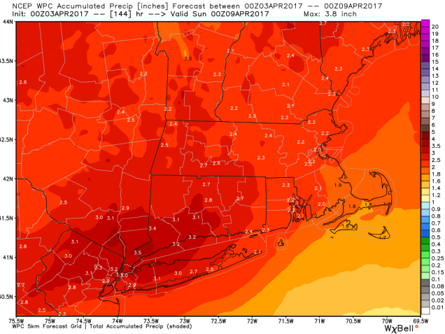
The potential exists for 1-3 inches of rain across the region this week. That could cause some flooding problems by late in the week. Image provided by WeatherBell.

There are some models that are showing the potential for warmer weather to finally move in early next week for at least a couple of days. That’s still a long ways off though, so don’t count on it just yet. We wouldn’t put away the snowbrush either, just in case. We have had measurable snow around here in May before.

sfct.us_ne
The GFS is trying to bring some really nice weather into the region next week. Will it actually happen? We’ll see. Image provided by Pivotal Weather.

Monday: Morning sunshine fades behind increasing afternoon clouds. High 51-58, cooler right along the coast.

Monday night: Cloudy with showers developing, possibly starting as some sleet or freezing rain in southern NH. Low 31-38.

Tuesday: Breezy with rain likely. High 39-46.

Tuesday night: Showers taper off and end. Low 33-40.

Wednesday: More clouds than sunshine, chance for a shower or two, mainly in the morning.  High 46-53.

Thursday: Windy with rain likely.  High 44-51.

Friday: Mostly cloudy with scattered showers. High 49-56.

Saturday: Mostly cloudy with more showers possible. High 47-54.

Sunday:  A mix of sun and clouds. High 48-55.

First Pitch Forecast: Sunshine dimmed by high clouds, winds blowing in from CF, and a game-time temperature around 48 degrees. Go Sox! #WinDanceRepeat

Out Like A Lamb? Not This Time

March is supposed to come in like a lion and go out like a lamb, or so the old saying goes. Well, it certainly came in like a lion, but now it’s also going to go out like a lion too. Don’t worry, a repeat of the April Fool’s Blizzard in 1997 is not coming, but we do have some snow to worry about across parts of the region.

day1otlk_1300
Looks like an active day for severe weather from the Ohio Valley to the Gulf Coast today. Image provided by the Storm Prediction Center.

The storm that we’ll have to contend with Friday into Saturday is moving into the Midwest today, with plenty of severe weather expected ahead of it. This system has already produced a lot of severe weather from the Southern Plains and Texas into the Mississippi Valley over the past couple of days. Don’t worry, we won’t have to contend with severe weather up here. As the storm heads into the Midwest, it will eventually redevelop off the Mid-Atlantic coastline and pass south of New England late Friday into Saturday. Meanwhile, high pressure will move into eastern Canada, keeping some marginally cold air in place, setting the stage for a return of wintry weather to New England.

We’ll have some snow or rain showers developing Friday morning, but with temperatures in the 30s to lower 40s, we won’t see much, if any, accumulation during the daytime. The sun angle is getting relatively high, so even with the cloud cover, it still is strong enough to prevent much accumulation, at least on paved surfaces.

nam4km.refcmp_ptype.us_ne.2017033012-loop
Forecast for the high-resolution NAM model for the Friday/Saturday storm system. Loop provided by Pivotal Weather.

After the sun sets, things get a lot more complicated. Without the sun, and with temperatures dropping into the lower to middle 30s, along with the heaviest precipitation moving in, we’re looking at a changeover to snow for most places, especially away from the coastline. The problem is, some warmer air looks like it will move in aloft for a while. With a warm layer aloft, the snow that’s falling melts, then starts to refreeze as it moves back into the colder air below that layer. The result is sleet, and possibly a lot of it well inland. This will significantly cut back on snowfall accumulations.

Once we get into Saturday morning, a change to rain is likely for much of the region, but even where it stays mostly snow, we won’t have much additional accumulation, at least on paved surfaces.  A few showers may linger into Sunday as an upper-level storm system moves across the region, then high pressure brings sunshine and seasonably cool temperatures in for Opening Day at Fenway on Monday.

So, how much snow are we looking at? We’ve bumped up amounts a little since yesterday, but nothing significant:

South of the Mass Pike: A coating at most.
Metro Boston: 1-2″
128 Belt: 2-4″
Merrimack Valley: 3-5″
NH Seacoast/North Shore: 3-6″
Southern NH: 4-7″
Worcester Hills/Monadnocks: 5-10″

hires_snow_boston_61
The high-resolution NAM model is probably closest to our thinking for snowfall amounts. Image provided by WeatherBell.

Before you ask, no, this is probably not the last time we’ll see snowflakes this season. It may be the last “snowstorm”, but even that’s not a definite. Remember, we’ve had snowstorms around here into late April and early May before.

No Joke – Snow Possible for April Fool’s Day

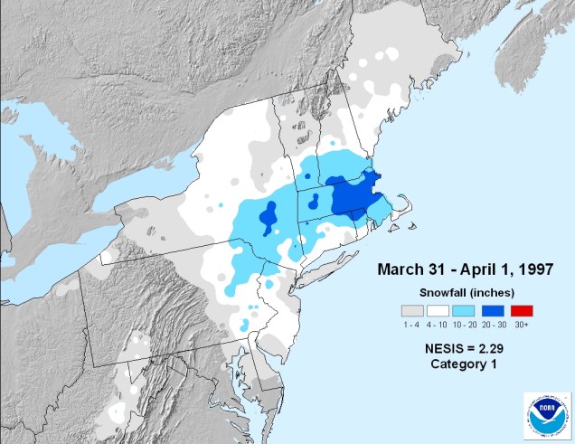
Easter Sunday, 1997. It’s a beautiful day with sunshine and temperatures getting into the 60s. So why are the meteorologists talking about Winter Storm Warnings? Well, as we all remember (at least those of us who lived around here at the time), we went from 60 degrees on Sunday to 2 feet of snow by Tuesday.  While there’s more snow in the forecast for March 31 and April 1 this year, we’re not expecting anything remotely close to what happened 20 years ago.

19970331-19970401-2.29
Mother Nature certainly played one hell of a joke on all of us in 1997. Image provided by NOAA.

As we get into late March and early April, it becomes harder and harder to get a significant snowstorm around here. Oh sure, it’s happened plenty of times (just look at the map above), but we really need everything to be setup perfectly for it to happen. For Friday and Saturday, things are not setup perfectly, and that’s why we’re not expecting a big storm.

The storm system bringing severe weather to parts of the nation’s midsection yesterday and today will head towards the Great Lakes over the next day or two, then eventually redevelop off the Mid-Atlantic coastline on Friday. Meanwhile, high pressure building in north of us will bring sunshine and relatively cool weather in for Thursday. As that high moves into eastern Canada on Friday, it will allow winds to shift into the east and southeast across the area at lower levels of the atmosphere. As these winds blow in off the ocean, where water temperatures are in the upper 30s to lower 40s, it will allow air temperatures to rise to those same levels along the coastline.

Inland areas could be a different story. Winds may stay out of the north, allowing cold air to remain in place, keeping temperatures in the lower to middle 30s. As the precipitation moves in during the day, we’ll see it start as rain in many places, but well inland, and especially in some of the higher terrain, we’ll see snow, or at least a mix of rain and snow. Even though it may be snowing during the day, we’re not expecting much accumulation. The sun angle is getting relatively high, so even with the cloud cover, it still is strong enough to prevent much accumulation, at least on paved surfaces.

nam.refcmp_ptype.us_ne.2017032912-loop
NAM model forecast for the Friday/Saturday storm system. Loop provided by Pivotal Weather.

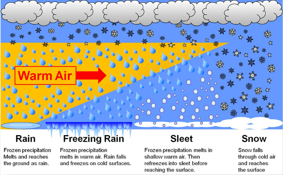
This brings us to Friday night, which is where things get very tricky. Without the sun, and with temperatures dropping a bit, along with the heaviest precipitation moving in, we’re looking at a changeover to snow for most places, and possibly some heavy snow, especially away from the coastline, right? Not exactly. Some warmer air looks like it will move in aloft for a while, about 7,000-10,000 feet above ground. With a warm layer aloft, the snow that’s falling melts, then starts to refreeze as it moves back into the colder air below that layer. The result is sleet, and possibly a lot of it.

raipzrsn
This graphic shows the difference in how you get snow vs sleet vs freezing rain. Image provided by NOAA.

Everything should change back to rain before ending on Saturday, but temperatures will likely only be in the 30s to lower 40s again. Not exactly a nice early Spring day across New England. A few rain or snow showers may linger into Sunday as an upper-level disturbance moves through, but sunshine should return on Monday, just in time for Opening Day at Fenway.

So, by now you’re wondering how much snow can we really expect? You’ve probably seen some of the model forecast snow maps posted on the internet or on TV already. Ignore them. All of them. They are useless in storms like this. Here’s what we’re thinking right now for accumulations:

Inside of 128: Little to no accumulation
Merrimack Valley/NH Seacoast/Northeast MA (away from the coast): 1-3″
Southern NH: 2-4″
Worcester Hills/Monadnocks: 3-6″

All in all, not a big storm, but the roads could be slick Friday night and Saturday morning, so if you have to head out during those times, please slow down and be careful. If anything changes, we’ll update this post on Thursday.

Weekly Outlook March 27-April 3, 2017

As we prepare to flip the calendar from March into April, it looks like a week of typical springtime weather in New England is in the forecast. What exactly is “typical springtime weather” in New England? Why, it’s a little bit of everything. Let’s get to the details.

The week starts off chilly and damp as a warm front tries to approach from the south. As rain moves in ahead of it, temperatures will be on the cool side, so we may even see a little freezing rain in the morning well north and west of Boston. If you live there or have to head there in the morning, take things a little on the slow side. The rest of Monday will be fairly wet, as a wave of low pressure rides along that front across the region. We’re not sure that front ever makes it completely across the region, so if you were expecting some milder conditions, you may be out of luck, especially the farther north you head. Another wave of low pressure rides along the front on Tuesday, giving us more rainfall. While a couple of cool and wet days doesn’t sound good, the rain is beneficial. We are still in a drought across the region, and need plenty more rainfall to break it.

20170321_northeast_trd
We still need a lot more rain to break the drought. Image provided by National Drought Monitor.


Once that wave of low pressure moves by Tuesday night, high pressure then builds in for Wednesday and Thursday. So, we’ll finally get some sunshine again, especially away from the coastline, but it will remain on the cool side, with temperatures staying a little below normal. (Highs should generally be in the lower to middle 50s as we head into early April.) This brings us to Friday and Saturday. Another system will approach from the west very slowly, and likely pass to our south. That means another extended period of precipitation across the region. Notice, we said “precipitation” and not “rain”. That’s because it might not all be just rain. Yup, the dreaded “S-word” is possible again. It’s a little too early to tell how likely it is, but the best chance for any accumulating snow would probably be in the higher terrain. As we head into April, it becomes tougher and tougher to get accumulating snow around here, especially during the daytime. Oh, it’s happened plenty of times, but you need things to be set up just right, and this doesn’t look to be that type of setup right now. Showers may linger around here into Sunday before high pressure starts to build in again. Right now next Monday looks partly cloudy and seasonably cool. If you have to ask why we’ve included Monday, then you’re probably not from around here.

609fenway_OD
Opening Day should be a National Holiday. Image provided by Boston.com

Monday: Periods of rain, possibly some freezing rain well north and west of Boston in the morning. High 37-44, except 44-51 south of Boston.

Monday night: Rain tapers off in the evening, then becoming mostly cloudy with some patchy drizzle. Low 33-40.

Tuesday: Cloudy with rain and showers redeveloping. High 47-54.

Tuesday night: Cloudy with showers tapering off and ending. Low 34-41.

Wednesday: Skies may remain cloudy with some lingering drizzle or showers along the coast, becoming partly to mostly sunny well inland. High 45-52, coolest along the coast.

Thursday: Partly to mostly sunny. High 42-49, coolest along the coast.

Friday: Becoming cloudy with showers developing, possibly mixing with or changing to snow well north and west of Boston, especially at night. High 40-47.

Saturday: Breezy with rain likely, possibly mixed with snow well north and west of Boston. High 39-46.

Sunday: Cloudy skies with showers possibly lingering in eastern areas into the morning. High 46-53.

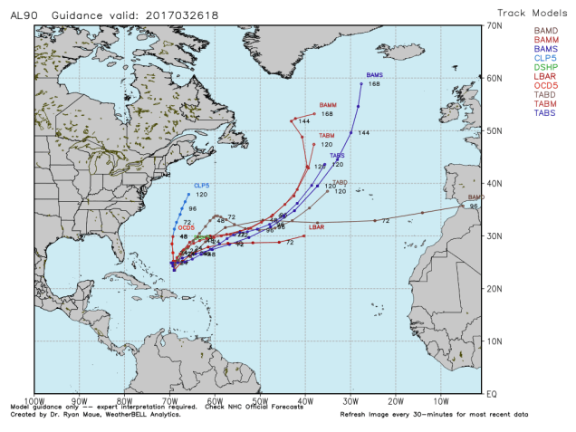
Finally, here’s something that we find this interesting, and since this is our blog, we’re going to tell you about it. There’s a tropical disturbance east-northeast of the Bahamas that is being watched for development right now. Yes, it’s March. No, it’s not unheard of, though it is fairly rare. It’s not expected to develop into a tropical system, but could become quite a gale in the North Atlantic this week.

AL90_current
It’s not very often you see the tropical suite of models run for a system in the Atlantic in March. Image provided by WeatherBell.


Weekly Outlook: March 20-26, 2017

Astronomical spring starts today at 6:29am, and for part of this week, it will actually feel like Spring. Of course, that means part of the week won’t feel like Spring. Sorry to disappoint you, but the parts that don’t feel like Spring won’t feel like Summer. Yup, that means they’ll feel like Winter. It is still March after all.

The week will start off with low pressure continuing to pull away from the area and high pressure building in. That means sunshine, diminishing winds and mild temperatures. A weak front moves through tonight, bringing some clouds with it, and little more than that. Tuesday will have plenty of clouds and some sunny breaks, but it will be a few degrees warmer than Monday. We’re heading in the right direction, right? Wrong. A stronger cold front moves through Tuesday night, with a few snow showers possible. Skies quickly clear out behind it giving us plenty of sunshine on Wednesday, but it will be windy and much colder. Possibly even cold enough to set a few records. Yeah, that’s cold. High pressure builds in later Wednesday into Thursday with sunshine, diminishing winds. We start to warm up on Friday as a warm front approaches, possibly bringing a few showers with it. Whether that warm front actually makes it through or not is still not set in stone.

ndfd_record_low_neng_4
Thursday morning will be chilly, with some record lows possible in the Northeast. Image provided by WeatherBell.

This brings us to next weekend. This is where things get complicated. If the warm front moves through, Temperatures on Saturday could spike into the 60s in many areas, especially if we get any sunshine. If the front doesn’t come through, we might stay in the 40s all day. For now, we’ll stay right in the middle, with upper 40s to middle 50s, but please realize that temperatures could be considerably warmer or colder than what we are forecasting at the moment. Regardless of whether the warm front moves through, a cold front will drop southward across the region later on Saturday, bringing in some showers and cooler conditions, especially if we get into the warm air. That front will stall out south of New England on Sunday while a wave of low pressure moves along it. Exactly how quickly that wave moves along the front and how far south the front stalls are key to the forecast. Right now, it looks to be a little too far south and moving a little too quickly, which means that most of the precipitation moves out before the colder air settles in. That means the rain may end as some snow on Sunday, with only a little accumulation in some spots. However, there are some models that have the front stall a little closer to the South Coast, and the wave moves through a little slower. The result is a better chance of some accumulating snow later Sunday into Monday, and for at least one model, a lot more accumulating snow. For now, we’re leaning towards the solution with little to no snow, but the potential is there for more snow across the area. If anything does materialize, we’ll let you know later in the week. For now, don’t worry about changing any plans, but just keep an eye on the forecast on the off-chance that this does become a problem.

gfs_t2max_boston_25
A few models are showing the potential for highs in the 60s on Saturday. Not all of them show this though. Image provided by WeatherBell.

Monday: Mostly sunny skies with diminishing winds. Clouds start to move in late in the day. High 44-51.

Monday night: Partly to mostly cloudy. Low 25-32.

Tuesday: Intervals of clouds and sunshine. High 47-54.

Tuesday night: Slight chance for a rain or snow shower, then clearing skies and windy. Low 25-32.

Wednesday: Becoming mostly sunny, windy, and colder. High 30-37.

Thursday: Plenty of sunshine, still breezy and cold. High 29-36.

Friday: Becoming mostly cloudy, breezy, and milder with a chance of showers. High 40-47.

Saturday: More clouds than sunshine, chance for a few showers. High 48-55.

Sunday: Partly to mostly cloudy, chance for some snow or rain showers, especially along the South Coast. High 34-41.

March Madness Has Arrived

It’s time for March Madness once again, and we’re not talking about the NCAA Basketball Tournament. No, this time we’re talking about the relentless hype ahead of a March snowstorm. You’d think that we’ve never had a big storm around here in March before with the way the media is reacting. It’s almost as if everyone has forgotten about the storms in 199319972007, and 2013, never mind the ones we’ve had in April (or May).

Well, enough about that, let’s get right to the details of the storm. Low pressure is moving across the Ohio Valley today while a second area of low pressure is starting to develop off the Southeast coast. As the Ohio Valley system weakens tonight, it will transfer its energy to the coastal storm, and then the fun really begins.

The low will move up the coastline tonight into Tuesday and rapidly strengthen. Snow will break out across the region around daybreak Tuesday, and will fall heavy at times from mid-morning into the evening. Snowfall rates of 1-3 inches per hour seem likely. The snow will be accompanied by winds gusting to 40-50 mph at times, even higher near the coast, and especially across Cape Cod. This may create blizzard conditions at times, with significant blowing and drifting snow expected. We’d recommend that you stay off the roads, as travel will be dangerous at best during the daytime hours. The good news is that the storm will be moving relatively quickly, so the snow will taper off in the evening, and end at night.

hires_gust_boston_31
Strong winds will accompany the storm on Tuesday across much of the region. Image provided by WeatherBell.

The big wildcard at this point is the exact track of the storm. Some of the models are trying to indicate that the storm will move across southeastern Massachusetts late in the day, while others keep the storm near or just east of Cape Cod. The farther the storm tracks to the west, the more likely a change to sleet and/or rain becomes across southeastern Mass, possibly as far inland as the I-95 corridor. Obviously, that will have a big impact on snowfall totals.

So, how much snow are we looking at? Well, many in the media have been throwing out amounts like 1-2 feet or some other ridiculous numbers. The fact is, with a storm moving as quickly as this one is (it’s only going to snow for about 12-15 hours), it’s tough to get amounts that high. Our forecast is as follows:

Cape Cod: 3-6″ on the Outer Cape and Islands, 5-10″ closer to the Canal

SE Mass/RI: 6-10″ from I-95 south and eastward, 10-16″ north and west of there.

The remainder of Central & Eastern Mass/N RI/Southern NH/southern ME: 12-18″, with isolated heavier amounts.

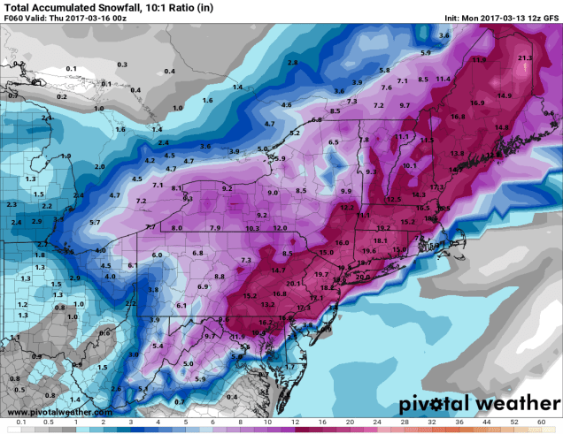
sn10_acc.us_ne (1)
GFS model forecast for snowfall through Wednesday evening. This model most closely matches our thinking for snowfall right now. Image provided by Pivotal Weather.


Even though the snow will be winding down Tuesday night, Wednesday won’t be a great day for cleanup. With an upper-level low moving across the region, and the storm itself getting cranked up in Atlantic Canada, it’ll be cloudy, windy, and cold, with scattered snow showers. While there shouldn’t be much additional accumulation. Another inch or two is possible in a few spots.