After several days of sunshine and record-breaking warmth, we’re going to be dealing with cooler conditions and some wet weather at times in the next few days. In other words, welcome to November.
November is off to a very warm start across the Northeast. Image provided by the Northeast Regional Climate Center.
Our record warmth is now a memory as a cold front has moved across the region. That front will stall out just to the south tonight, and a wave of low pressure will ride along it on Friday, bringing us some more showers as cooler air continues to settle into the area. Temperatures on Friday will be 25-30 degrees colder than they were on Wednesday.
Average high temperatures for mid-November are in the lower 50s across the area. Image provided by Weathermodels.com
High pressure builds in on Saturday with sunshine and temperatures that are more representative of mid-November. Sunday will start off dry, but another cold front will be approaching the region. We should turn milder again ahead of that front, but not nearly to the extent of what we’ve had for the past week. Showers are likely Sunday night into Monday morning as the front moves through. We’ll dry out and turn breezy and cooler again Monday afternoon as that front pushes offshore.
Thursday night: Cloudy with some patchy drizzle and a few showers. Low 37-44.
Friday: Scattered showers. High 46-53, possibly a little cooler north and west of 495.
Friday night: Clearing. Low 32-39.
Saturday: Mostly sunny. High 44-51.
Saturday night: Clear to partly cloudy. Low 26-33.
Sunday: Some morning sun, then clouds move in during the afternoon with showers possible toward evening. High 52-59, possibly cooler in southern New Hampshire.
Sunday night: Cloudy and breezy with showers likely, ending before daybreak. Low 37-44.
Monday: Partly to mostly sunny and breezy. High 47-54.
The warm and dry weather will continue for a couple more days, but changes are coming.
High pressure remains in control into early Wednesday, which means we’ve got a few more more days with near-record temperatures across the region. While the days will be sunny and warm, the nights will be a bit different. Some low clouds and fog are possible in some areas, especially near the coast. For areas that don’t get any fog, clear skies and light winds will allow for radiational cooling.
Record highs will likely be broken across the Northeast again this afternoon. Image provided by Weathermodels.com
Wednesday is when the changes start happening. A strong cold front will approach from the west. Ahead of it, we’ll have some rain later Wednesday into Thursday, but it will remain warm, especially if we can get any sunshine during the morning. Since we’re still in a significant drought, and it hasn’t rained for a week, any rain is good news. While we may get some heavy rain, especially along the South Coast, it looks like the bulk of the heavy rain, some of which will be aided by moisture streaming northward from Eta, should stay south of the region.
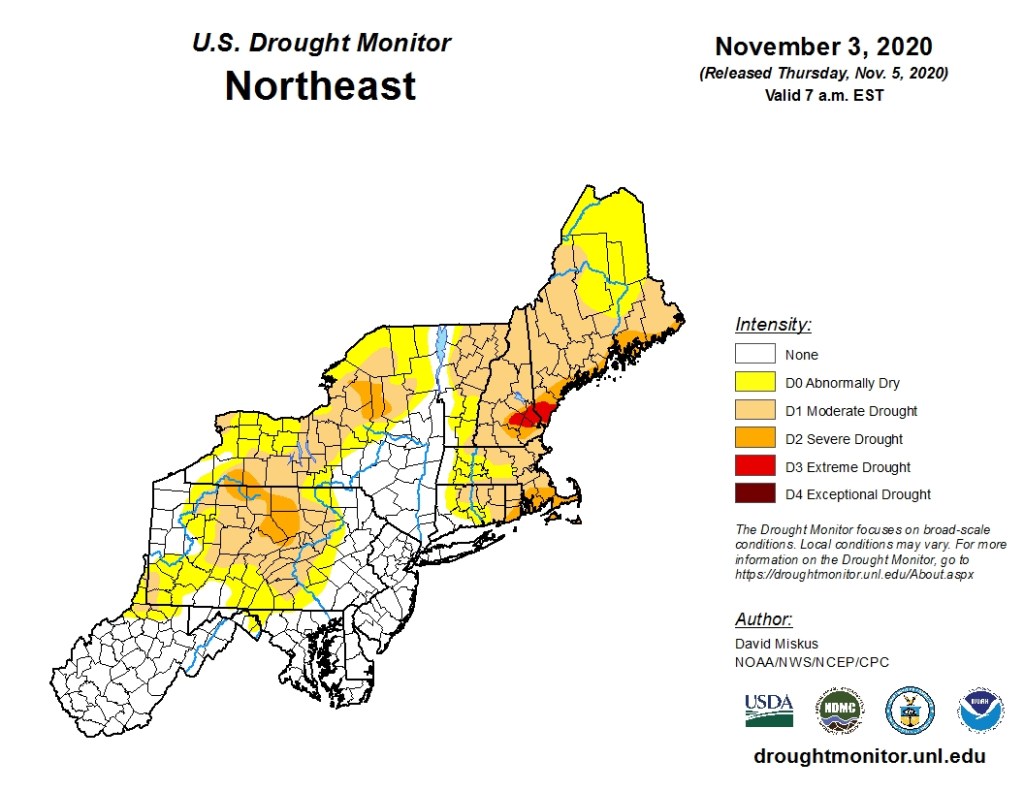
Much of the region remains in a significant drought. Image provided by the National Drought Mitigation Center.
As the front moves offshore, the rain should taper off and end Thursday evening, but the front will stall out south of the region. How far south is still a bit of a question, but it may remain close enough for some additional showers on Friday, mainly along the South Coast, as a wave of low pressure rides along the front.
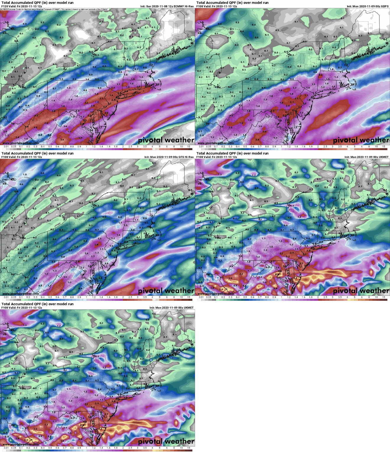
How much rain will we get this week? Some models show a decent amount, some don’t. Which will be right? Images provided by Pivotal Weather.
High pressure builds in later Friday into Saturday with some cooler conditions, but temperatures will still be near to above normal for mid-November, especially on Friday. Sunday is a bit of a question mark as the next system will be starting to approach from the west, but there are significant differences in the timing of this system, depending on which model you decide to look at.
Monday: Some patchy morning fog, then becoming mostly sunny. High 68-75.
Monday night: Clear skies, some low clouds and fog may return in some spots. Low 45-52, though some spots could drop as low as the upper 30s..
Tuesday: Sunshine and a few clouds. High 67-74.
Tuesday night: Clear to partly cloudy, again some low clouds and fog may develop. Low 52-59.
Wednesday: Some early sun, then becoming cloudy and breezy with showers developing late in the day, becoming a steady rain at night. High 67-74.
Thursday: Plenty of clouds with rain likely, ending late in the day. High 59-66.
Friday: A mix of sun and clouds, a few showers are possible along the South Coast, especially early. High 49-56.
Saturday: Mostly sunny and breezy. High 48-55.
Sunday: Mostly cloudy with a chance of showers. High 47-54.
This will likely be the shortest update we’ve ever written. High pressure remains in control right through the weekend and into the start of next week with generally fair weather and unseasonably mild temperatures.
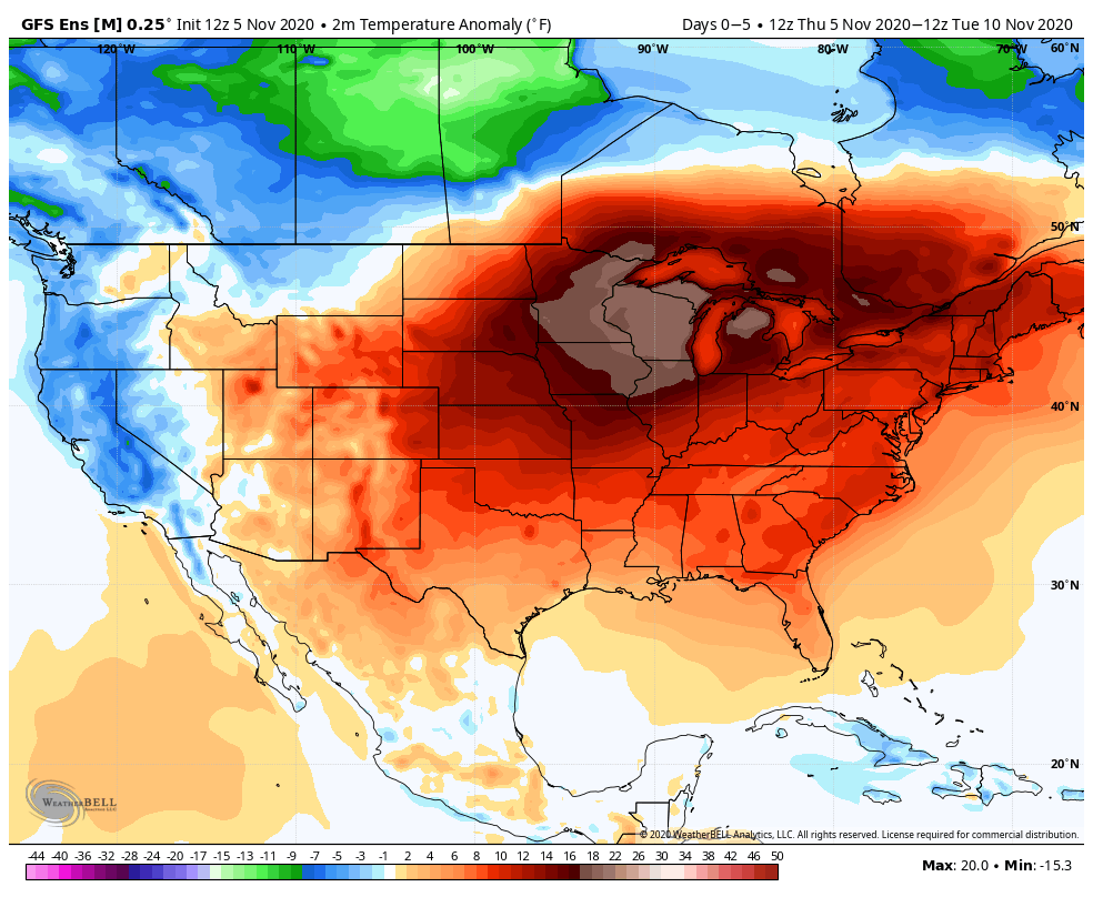
While it’s quite mild here, temperatures will be as much as 20 degrees above normal across the Midwest this weekend. Image provided by WeatherBell.
Thursday night: Partly to mostly cloudy. Low 47-54.
Friday: Becoming mostly sunny, a little breezy at times. High 64-71.
Friday night: Clear to partly cloudy. Low 44-51.
Saturday: Sunshine and some high clouds. High 65-72.
Saturday night: Clear skies. Low 41-48.
Sunday: Plenty of sunshine. High 63-70, a little cooler right along the coast.
We’ve got a busy start to the week, then things get rather simple as we head into the middle and end of the upcoming week.
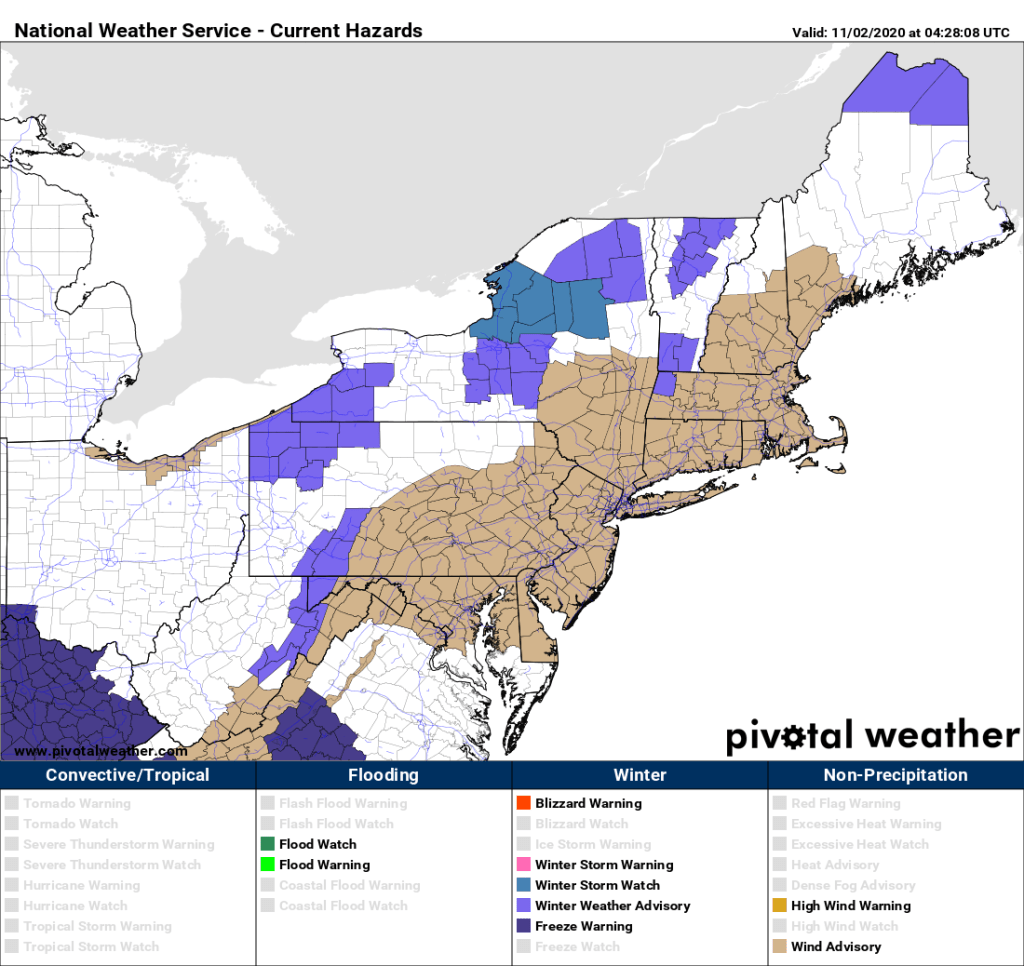
Wind Advisories are in effect for much of the Northeast for Monday. Image provided by Pivotal Weather.
We start off with a blustery and chilly day in the wake of a strong cold front that moved through overnight. Gusty west to northwest winds will usher some chilly air back into the region, similar to what we had on Saturday. There will be some sunshine, but also a decent amount of cloudiness. The clouds will become more widespread at night as winds die down, thanks to an approaching Alberta Clipper. This will move through early Tuesday morning, bringing in some snow or rain showers, maybe even a few squalls. We’re not expecting much, if any, accumulation for most of us, but any squalls could whiten the ground and possibly drop up to half an inch of snow. These will be most likely north of Route 2, especially in the Worcester Hills and the Monadnocks of southwestern New Hampshire. Once that system moves through, skies will clear out, but we’ll have another blustery and chilly afternoon on Tuesday.
Wind gusts of 35-45 mph are possible across the region today. Image provided by WeatherBell.
Conditions become more tranquil on Wednesday as high pressure builds in with sunshine, lighter winds, and moderating temperatures. After that, the high moves offshore and remains there for the rest of the week and into the weekend. The result is generally fair weather with above normal temperatures. Some places could even make a run at 70 by next weekend.
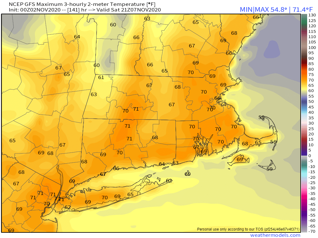
Temperatures could reach 70 in many areas this coming weekend. Image provided by Weathermodels.com
Monday: Intervals of clouds and sunshine, windy, and chilly. High 36-43.
Monday night: Partly to mostly cloudy, rain or snow showers possible late at night. Low 27-34 during the evening, temperatures hold steady or rise a bit overnight.
Tuesday: Any rain or snow showers (or squalls) ending in the morning, then becoming partly sunny. High 40-47.
Tuesday night: Clear skies. Low 23-30.
Wednesday: Plenty of sunshine, milder. High 48-55.
We’ve got a little bit of everything coming up in the next few days, but that’s actually fairly typical for autumn.
The weekend starts off on a stormy note as the remains of Zeta pull away tonight while a second system quickly follows. The heaviest rain is expected this evening and the first part of tonight from Zeta’s remains, but as it pulls away, it will draw some colder air into the region just as the second storm moves in. As that colder air moves in, we’ll see the rain mix with and change over to sleet and wet snow, first in the hills of southwestern New Hampshire and central Massachusetts early Friday morning, then across the rest of southern New Hampshire and eastern Massachusetts by daybreak or shortly thereafter. Everything should wind down by early afternoon, followed by rapid clearing and diminishing winds (more on this in a moment).
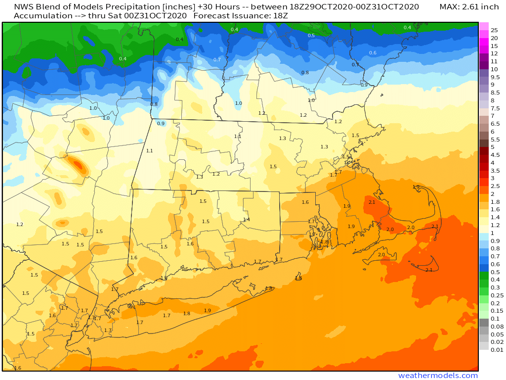
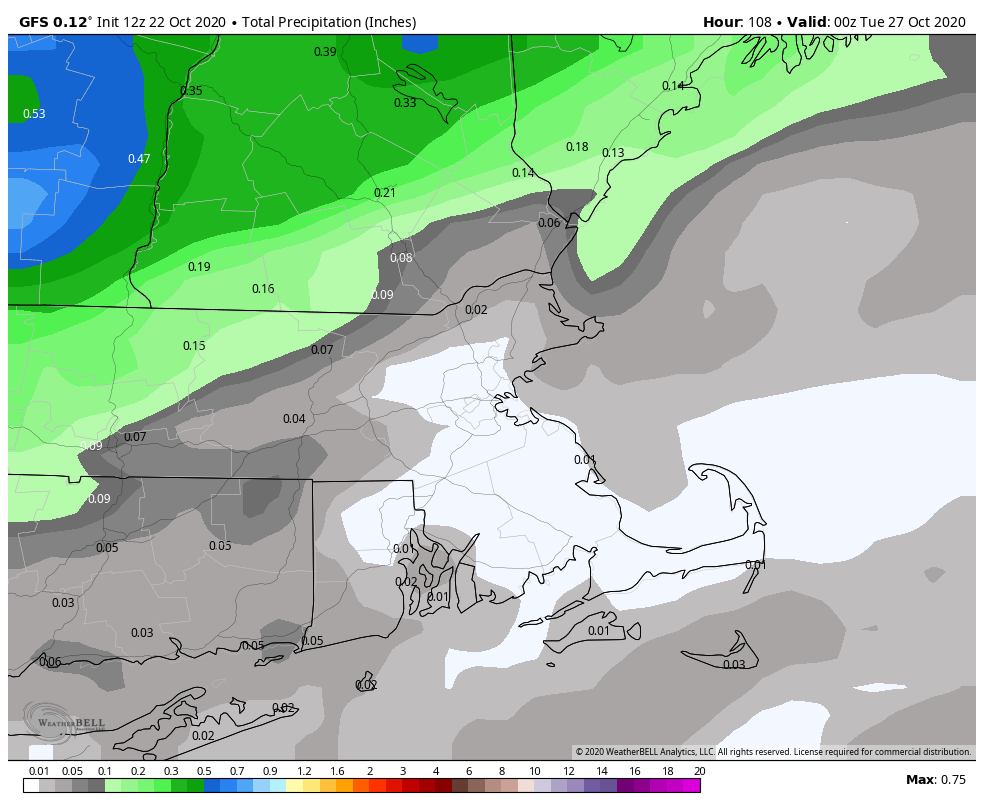
The rainfall tonight and early Friday will be beneficial and help put a dent in the ongoing drought. Image provided by Weathermodels.com
Since the National Weather Service has posted Winter Weather Advisories for the interior of the region, you must be expecting some decent snow, right? We don’t think so. Across the hills of Worcester County and the Monadnocks, a few inches may accumulate, possibly a little more on top of the hills. For Southern New Hampshire (Concord-Manchester-Nashua), you could see an inch or so, maybe two inches in a few spots, mainly on grassy surfaces. From the New Hampshire Seacoast into the Merrimack Valley of Massachusetts we’re looking at an inch or less, again mainly on grassy surfaces. For the rest of us, just a mix of rain or snow, maybe enough to coat the grass in some spots, mainly from Metro West to the North Shore.
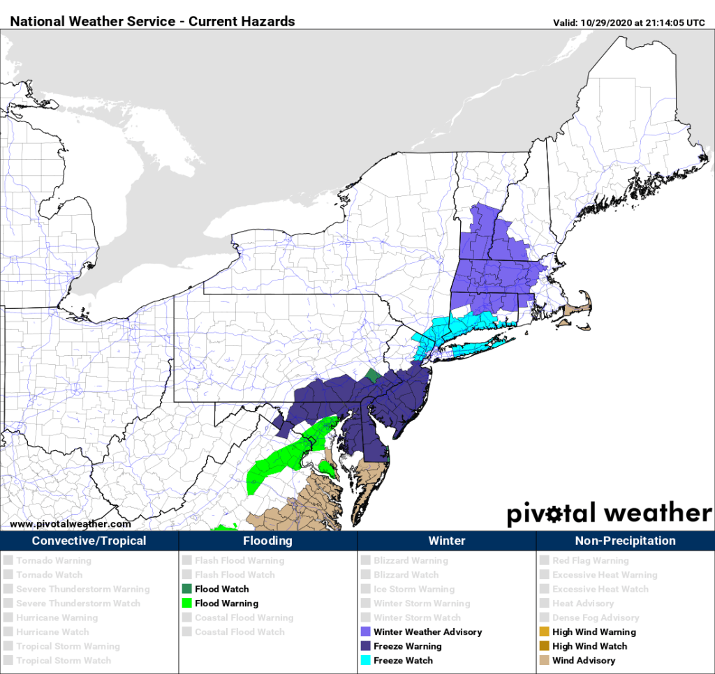
Winter Weather Advisories have been posted for interior portions of New England. Image provided by Pivotal Weather.
Why is our forecast for less than most of the TV and NWS forecasts out there? Most of the forecast models are showing the potential for 1-3, possibly as much as 6 inches of snow. However, a lot of people seem to forget a few things. First, those maps assume a 10:1 ratio of snow to liquid (1 inch of rain equals 10 inches of snow). With temperatures near or just above freezing, the ratio won’t be 10:1, more like 7 or 8 to 1, so that trims to 20-30% off of the map totals. Second. the ground is still relatively mild. While this impact is minor, it just means that the snow won’t stick initially, as it will melt on contact until the ground cools a bit more. So that may take away another 10% of the model totals. Factor those into the model forecasts, and you arrive at the numbers we have.
Once the system pulls away, it will clear out as we mentioned before. Temperatures will drop quickly, likely bottoming out in the 20s across much of the region, maybe even upper teens in some spots. Any roads that are still wet during the evening may start to ice up, especially bridges, overpasses, and elevated roadways. Keep this in mind if you’ll be out Friday night or early Saturday morning. As for Saturday, it’ll be a rather chilly Halloween despite sunshine. High temperatures will only get up into the middle to upper 40s at best.
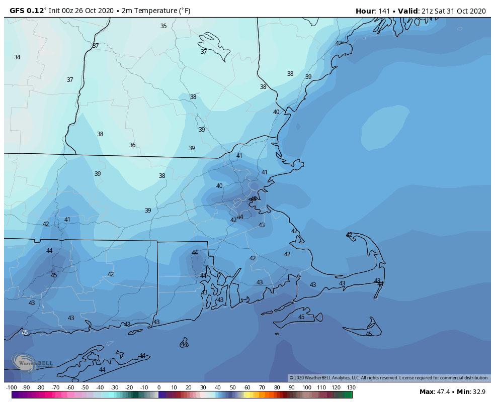
Temperatures will only be in the 30s Saturday evening, so make sure the kids are dressed properly for trick-or-treating. Image provided by WeatherBell.
Saturday night probably won’t be quite as cold, as winds will shift into the southwest and clouds will start to move in. Sunday will be milder, but with a cold front approaching, a few showers are possible during the afternoon and evening. Much colder air settles in behind that front on Monday, when temperatures will struggle to reach 40 in some spots. We may even see a few flurries. The good news is, it looks like it will start to warm up again later next week, but we’ll have more details on this on our Weekly Outlook Monday morning.
Most of next week should feature temperatures that are near or a little above normal for early November. Image provided by WeatherBell.
Thursday night: Breezy with rain, possibly heavy at times, gradually mixing with and changing over to sleet and wet snow. Low 30-37, except 37-44 across Cape Cod and the Islands.
Friday: Snow or a wintry mix ending around midday, then skies start to clear out with diminishing winds. High 34-41, a little warmer across Cape Cod and the Islands.
Friday night: Clear and chilly. Low 18-25, 26-33 across Cape Cod and the Islands.
Saturday: Sunny and cool. High 40-47.
Saturday night: Clear during the evening, clouds start to move in after midnight. Low 25-32, but temperatures may start to rise a bit after midnight.
Sunday: Cloudy with a few late-day showers possible. High 54-61.
Sunday night: Mostly cloudy, any showers end during the evening. Low 30-37.
Monday: A mix of sun and clouds, slight chance for a snow flurry or a sprinkle. High 39-46.
Here at Storm HQ, we like to separate fact from fiction, or more appropriately, hype from reality. So, we’re going to do that once again in regards to a few topics involving this week’s weather.
Claim: 2020 is now the most active Hurricane Season on record.
Reality: Nope, it isn’t. Not yet at least. With the formation of now-Tropical Storm Zeta a few days ago, many people, including many that should know better, were quick to proclaim that 2020 had now tied 2005 as the busiest Atlantic Hurricane Season ever, since the last named storm in 2005 was also Zeta. However, many people didn’t bother to review that 2005 season. Every year, when the season ends (officially: November 30), the folks down at the National Hurricane Center do a review of everything, to see if there were any storms that they missed. It turns out, that in 2005, there was an unnamed subtropical storm that was added after the fact. So, 2005 ended up with 28 storms of tropical storm strength, and 2020 only has 27 such storms so far.
For those counting, 2005 still holds the record for the most number of named storms in a season (28). NHC identified an "unnamed" subtropical storm in its post-season analysis that year, which is included in the total. With #Zeta, the number for 2020 currently stands at 27.
As for Zeta itself, after making landfall in the Yucatan just south of Cancun last night with maximum sustained winds near 80 mph, it has weakened to a tropical storm. However, as of midday, the center was moving into the Gulf of Mexico, and it is expected to re-intensify into a hurricane later today. While Zeta is currently heading northwestward, a turn more toward the north and eventually northeast is expected over the next 24-36 hours, as a trough of low pressure in the nation’s midsection pulls the storm in. Unfortunately, that means that Zeta will likely make landfall as a hurricane late Wednesday afternoon or evening along the central Gulf Coast. The current forecast has landfall in southeastern Louisiana, but anywhere from western Louisiana to the Florida Panhandle should keep an eye on Zeta’s progress. Strong winds, storm surge, and flooding from heavy rain are all threats with this storm.
Tropical Storm Zeta is moving into the Gulf of Mexico at midday. Loop provided by Tropical Tidbits.
Claim: An historic arctic outbreak is impacting much of the Rockies and Plains.
Reality: This one is definitely true. It’s been brutally cold out there for the past few days, with many records not only being broken, but being annihilated, and in some cases, these records have stood for over 100 years. In Bozeman, Montana, the low temperature Monday morning was 20 below zero. The record low for the day was 11 above zero, set back in 2002. When a record low is broken by 31 degrees, that’s historic. The low of -20 also shattered that city’s record low for the month of October, which was -14. Again, beating a monthly record by 6 degrees doesn’t happen that often. A little farther to the south is the town of Lyman, Wyoming. Lyman was the nation’s cold spot on Monday, when the low temperature bottomed out at 31 degrees below zero. That’s the actual temperature, not the wind chill. This is the earliest in the season that anywhere in the Lower 48 states has ever dropped to 30 below or colder, breaking a record set on October 29, 1917. With all of this cold air in place, and a storm system in the Desert Southwest, snow and ice have been common from the Southern Rockies into the Southern Plains and parts of Texas. This storm system and the cold air will move eastward over the next few days, but the air should moderate significantly.
It’s a wintry morning from the Southern Plains into parts of Texas and New Mexico. Loop provided by Weathertap.
Claim: Snow in Southern New England in October means that Winter won’t feature much snow.
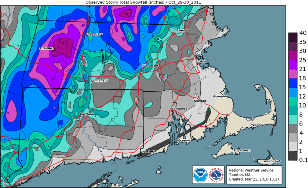
Reality: As with most things involving winter in New England, this one varies. Most people believe this to be true because after the big pre-Halloween snowstorm (“Snowtober”) in 2011, we didn’t get much snow through the rest of the winter. Something similar happened in 1979, when we received measurable snow on October 9-10, then little to no snow through most of the winter. The problem is, those aren’t the only times it’s ever snowed in October around here. Using data for Lowell, snow has been recorded in October during 18 of the past 91 years. During those 18 years, Lowell has averaged 53″ of snow, compared to a “normal” winter, when Lowell averages 55.8″ of snow. Of these 18 winters, all of them except for 1979-80, 2001-02, and 2011-12 featured at least one month between November and April with above normal snow. (1979 and 2011 both had above normal snow in October). Of the remaining 15, 12 of them had at least two months with above normal snow. Of the 18 overall, 13 of them featured above normal snowfall in either December, January, or both months. So, if we see some flakes on Friday, it does not automatically mean that we won’t see much this winter. (Sorry!)
After “Snowtober” we didn’t get much snow during the following winter, but that’s not always the case when it snows in October. Image provided by the National Weather Service office in Norton, MA.
Claim: The first snowstorm of the winter is expected on Friday.
Reality: Unless you live in the hills of Worcester County or in southwestern New Hampshire, this is probably not true. We talked about this in our Weekly Outlook yesterday – the pattern for the end of the week is complex, but things are looking a little clearer today. What’s left of Zeta will pass south of the region on Thursday, bringing some much-needed rain into the area. However, it looks like the bulk of the heavy rain may stay south of New England. Right behind it will be the system that is producing wintry weather across the Southern Plains. That system will pass to our south Thursday night and early Friday. As colder air gets drawn southward behind Zeta’s remnants, and the moisture from the second storm moves in, we’ll likely see the rain mix with or change over to sleet and snow across the hills of Worcester County and into the Monadnocks of southern New Hampshire. In these spots, we could see some minor accumulations, possibly a few inches. For the rest of us from southern New Hampshire into eastern Massachusetts, some sleet or snow will likely mix with the rain before it ends Friday afternoon. While there could be some slushy accumulations on grassy surfaces in southern New Hampshire and the Merrimack Valley, this is far from definite and certainly isn’t a “snowstorm”, despite any hype from the local media. Plus, as we mentioned at the start of this paragraph, it isn’t even that uncommon. It happens on average once every five years in Lowell, and the last time that it happened was – five years ago, in 2015.
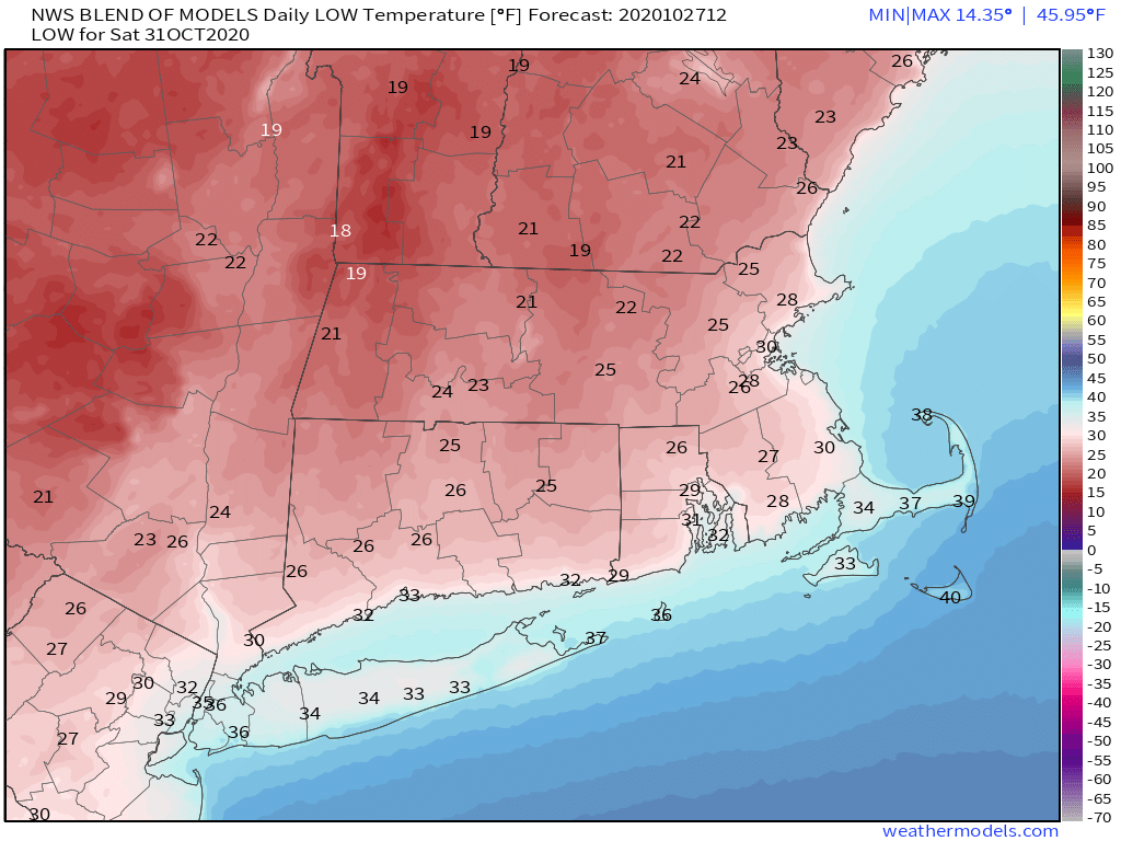
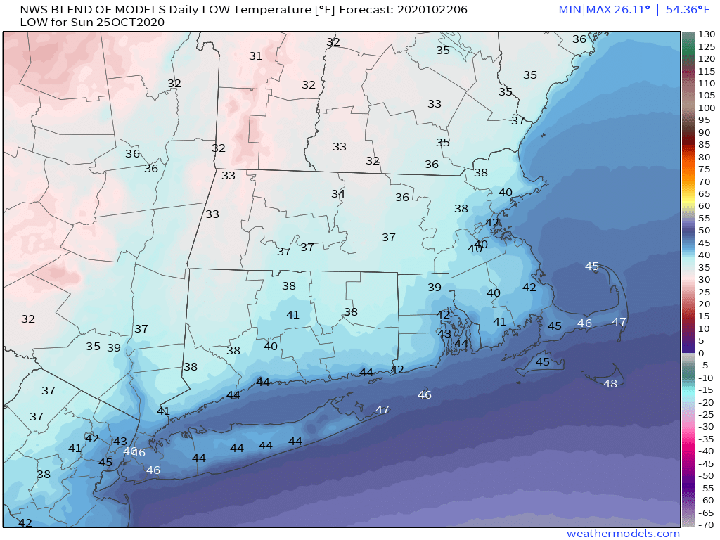
Saturday morning will be quite chilly across the region, with a killing freeze for everyone except possibly the Cape and Islands. Image provided by Weathermodels.com.
Once that storm moves away, some of the modified arctic air will move in, resulting in the coldest night of the season thus far. Temperatures will drop into the 20s across much of the area Saturday morning, resulting in a killing freeze in many places that have not yet had one. So, if you still have any plants outside that need to be brought in, now is the time. Despite sunshine, temperatures will only reach the 40s Saturday afternoon. For any kids that are trick-or-treating during the late afternoon or evening, temperatures will only be in the upper 30s to middle 40s, so make sure they are dressed properly for the weather.
It’s coming. Most of you don’t want to hear it, but you’re going to anyways. No, we’re not talking about changing the clocks this coming weekend. We’re talking about something scarier that happens before that, and it’s not Halloween either. It’s the first mention of “snow” in the forecast.
Turn your clocks back an hour Saturday night before bed. We don’t want to know what you’re doing with your hoe for that extra hour. Image provided by Wikipedia.
We’ll start the week with a rather “blah” day. A warm front will try to lift northward into the region, but probably won’t make it (a sign of things to come this winter?). As a result, we’re stuck with plenty of clouds, some drizzle and/or showers, and cool temperatures. A cold front will move through at night, with a few more showers possible. Behind the front we’ll have a couple of drier days for Tuesday and Wednesday, but as little upper-level disturbances move through, we’ll still have some clouds and maybe a shower or two. With high pressure to the north, we’ll still have easterly winds, so it will remain on the cool side, with temperatures generally running a few degrees below where they should be in late October.
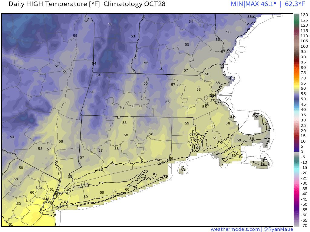
Average high temperatures in late October are in the upper 50s. Image provided by Weathermodels.com
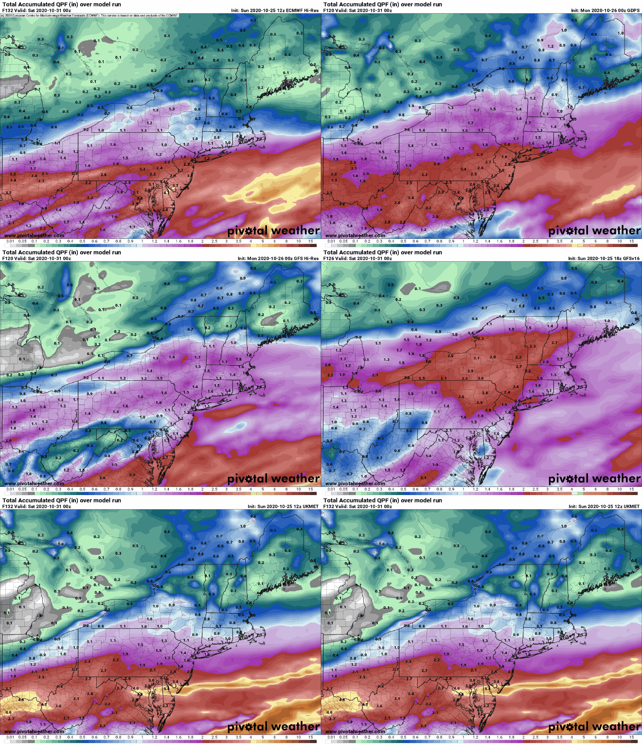
The end of the week is where things get interesting, complicated, and uncertain. A frontal boundary will remain stalled out south of the region keeping us cool. Meanwhile, what’s left of Tropical Storm Zeta will move across the Tennessee Valley and will likely ride along that boundary to our south. How far south that boundary lies will help determine how far north the rains from Zeta get. Thursday will be a cool, wet day obviously, but how wet remains to be seen. Some models are showing the potential for some heavy rainfall, especially along the South Coast, which would help somewhat with the drought, but also make the day even more miserable.
Some models show the potential for heavy rainfall this week while others show significantly less rain. Images provided by Pivotal Weather.
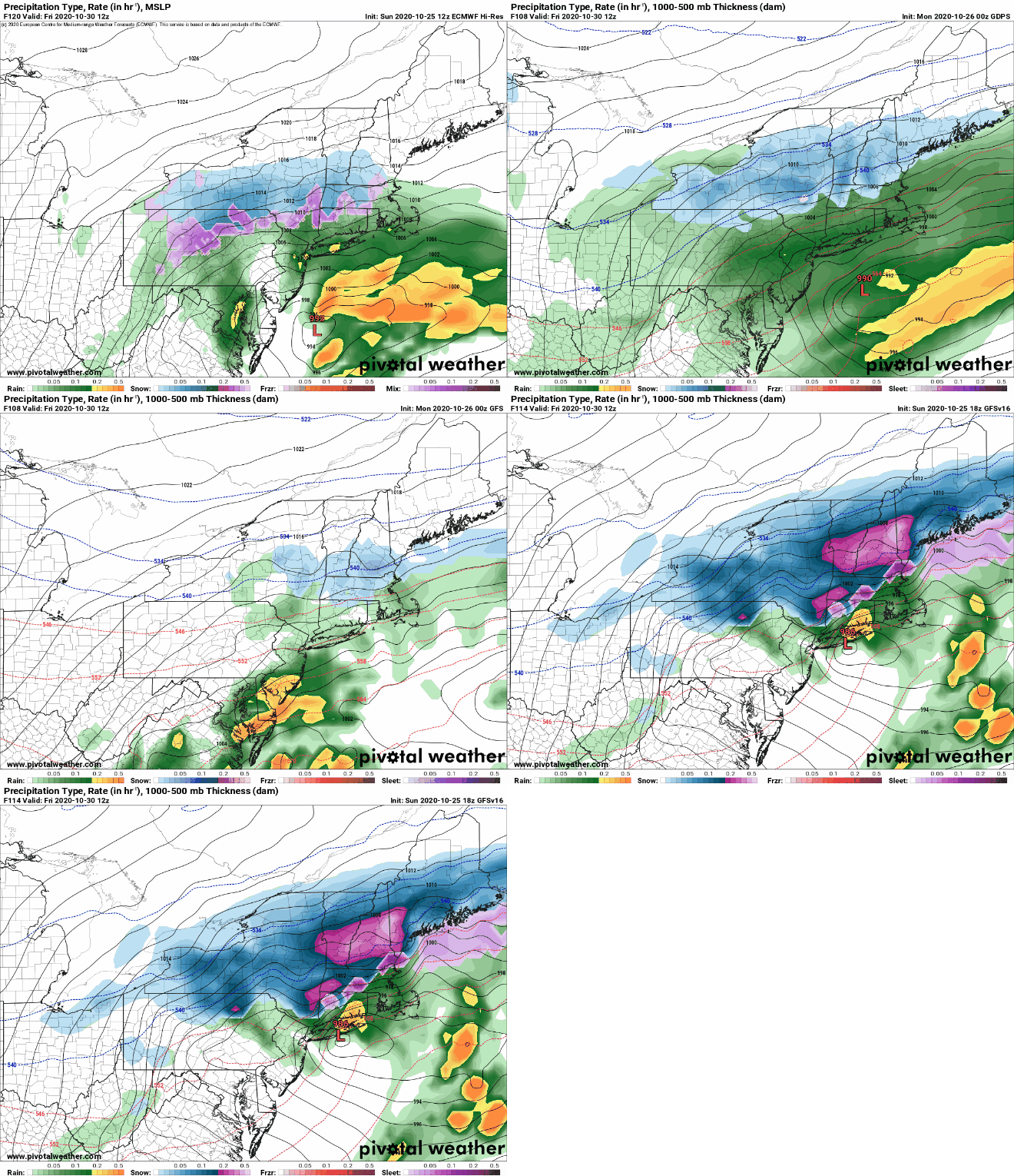
But wait, that’s not all. At the same time, an upper-level low will be moving out of the Plains and toward the Mid-Atlantic states, while another upper-level disturbance will be moving across the Great Lakes and towards New England. These two will help determine our weather for Thursday night and Friday. Some models show the potential for these two systems to join up or “phase”. This happens often during the winter to create some of our stronger storms. We’re not convinced that will happen here. Even if it does, it may not happen until the disturbances are past us, in which case, it won’t matter. Even if they don’t phase, we’re going to see colder air get drawn southward in the wake of Zeta’s remnants and as another low passes south of us. At the same time, we’ll have more precipitation moving in. So, while Friday will be another chilly and wet day, it’s becoming more likely that the rain will change over to wet snow in some of the hills from Worcester County into the Monadnocks, where there may even be enough to turn the ground white. For the rest of us, there are still too many variables to really be too definitive. We wouldn’t be shocked if some wet snow mixed in with the rain across parts of southern New Hampshire and eastern Massachusetts. There are some models that are forecasting accumulating snow around here. We can’t even rule that out, if everything lines up perfectly. We’re not expecting a repeat of “Snowtober”, but other than that, anything is possible.
The models still have a variety of solutions for Friday, leading to an uncertain forecast. Images provided by Pivotal Weather.
Once that system pulls away, high pressure builds in with sunshine and chilly temperatures for Halloween. Make sure the kids are bundled up if they are heading out to trick or treat, as it will be chilly Saturday evening. The high slides offshore on Sunday, allowing temperatures to moderate, but the next system will be quickly approaching, with some showers possible by evening.
Temperatures may only be in the lower 40s for Trick-or-Treat time Saturday evening. Image provided by WeatherBell.
Monday: Clouds, drizzle, fog, maybe a few showers. Blah. High 52-59.
Monday night: Cloudy with a shower possible. Low 44-51.
Tuesday: Clouds and some afternoon sunny breaks. High 52-59.
Tuesday night: Mostly cloudy. Low 33-40.
Wednesday: More clouds than sunshine, a few showers are possible. High 50-57.
Thursday: Cloudy with showers developing, possibly become a steady rain late in the day. High 50-57.
Friday: Cloudy and breezy with rain and showers possibly mixing with or changing over to some wet snow before ending in the afternoon. High 38-45.
Saturday: Plenty of sunshine. High 42-49.
Sunday: Some early sun, then clouds return with showers possible late in the day. High 51-58.
Temperatures will be riding a rollercoaster around here through the weekend, but as has been the case more often than not recently, little rainfall is expected.
Last week’s rain helped, but much of the region is still experiencing severe to extreme drought. Image provided by the National Drought Mitigation Center.
We’re starting off with a sunny and warm afternoon, but high pressure building in tonight will result in some cooler weather for Friday, as winds shift into the east. There may be a little patchy fog again tonight, but otherwise, we’ll have generally clear to partly cloudy skies into Friday.
That high will slide off to our east on Saturday, allowing us to warm back up, but clouds will also be streaming in ahead of a cold front. That cold front will move through during the afternoon, but it will be starved for moisture, so other than a spot shower or two, it should remain dry. However, you will notice the front in the temperature department. Temperatures could approach 70 during the afternoon, but will start to drop pretty quickly behind the front. By Sunday morning, many of us will see temperatures in the 30s to lower 40s. With high pressure building back in on Sunday we’ll have some sunshine, but north to northeast winds will keep temperatures in the upper 40s and 50s all afternoon.
After several mild nights, Sunday morning will be much cooler. Image provided by Weathermodels.com
We start heading back up the rollercoaster on Monday as low pressure passes north and west of the region, bringing a warm front through. This will allow us to warm up again, but it may also bring in some showers. They shouldn’t be too heavy or widespread, but at this point, any rain helps with our current drought. As the low moves by, it will drag a cold front through towards evening, with a few more showers possible, and sending temperatures downward again as we head into next week.
Little rainfall is expected between now and Monday evening. Image provided by WeatherBell.
Thursday night: Clear to partly cloudy with some patchy fog developing. Low 48-55.
Friday: A mix of sun and clouds. High 62-69.
Friday night: Partly to mostly cloudy, more fog is possible. Low 46-53.
Saturday: More clouds than sun, breezy late in the day, slight chance for a shower. High 65-72.
Saturday night: Clearing. Low 34-41.
Sunday: Sunshine and a few clouds, much cooler. High 47-54.
Sunday night: Becoming mostly cloudy. Low 36-43.
Monday: Cloudy with a chance for some showers. High 56-63.
Last week’s rainfall will help, but this week will bring little to no relief from the drought.
Most of New England received beneficial rainfall over the past week. Image provided by WeatherBell.
Much of the upcoming will will be dry across the region thanks to a large offshore high pressure area. That doesn’t mean it will be sunny every day, however. We’ll have a frontal system stalled out to our north and west for most of the week, with the high offshore preventing it from moving through. As waves of low pressure ride along the front, we’ll have some cloud cover, and a few stray showers may move in at times, especially Tuesday or Wednesday, but for the most part, it will remain dry.
Little to no rainfall is expected over the next week across the region. Image provided by Weathermodels.com
Although it won’t be completely sunny, it will be relatively warm for mid-October. We’ll have southwest winds bringing mild air in, with temperatures mainly in the 60s and 70s this week, which is 10 to 20 degrees above normal.
Well above normal temperatures are expected for most of the week. Image provided by WeatherBell.
By later Saturday, that cold front will finally have enough of a push to move through, but again, it won’t produce much in the way of rainfall, just a few showers. What will be noticeable is the cooler air settling in for next Sunday, bringing temperatures back where they should be for late October, maybe even a little below normal.
Monday: Sunshine filtered through some high clouds. High 58-65.
Monday night: Partly to mostly cloudy. Low 44-51.
Tuesday: Partly sunny, slight chance for a shower. High 64-71.
Tuesday night: Partly to mostly cloudy. Low 50-57.
Wednesday: Intervals of clouds and sunshine, chance for a shower or two. High 65-72.
Thursday: A mix of sun and clouds. High 67-74.
Friday: Partly to mostly sunny. High 61-68.
Saturday: Partly sunny, chance for a few showers late in the day and at night. High 63-70.
Sunday: A mix of sun and clouds, cooler. High 52-59.
After a good soaking a few days ago, we have more rain in our future.
Enjoy today’s weather, because things will be quite different tomorrow afternoon. Loop provided by the College of DuPage.
We’ve got a breezy and mild day in progress today, but changes are coming. Clouds will start to stream into the region tonight as a cold front approaches from the west. Showers will develop ahead of this front on Friday, making for a rather damp day. By late in the day, as the front moves into eastern New England, a wave of low pressure will ride along it from the south, bringing in some steadier and heavier rainfall at night. The models still disagree on how much rain we’ll actually get, but they all have come down significantly from the projected totals earlier this week of 2-3 inches, as expected. In fact, it wouldn’t be a surprise if parts of eastern Massachusetts receive less than 1 inch of rain from this system.
A decent slug of rainfall is on the way for the region. Image provided by WeatherBell.
The front pushes offshore Saturday morning, bringing an end to the rain. We’ll start to clear out behind the front during the afternoon, but it will be breezy and cool. High pressure then builds in for Sunday into Monday with dry and seasonably cool conditions.
It might be on the chilly side if you’re up early Sunday morning. Image provided by Weathermodels.com
Thursday night: Increasing clouds. Low 53-60.
Friday: Cloudy and breezy with showers developing by midday. High 64-71, but temperatures may drop quickly in the afternoon.
Friday night: Cloudy with periods of rain and showers, some of the rain may be heavy. Low 40-47.
Saturday: Rain ending in the morning, then becoming partly to mostly sunny and breezy. High 51-58.
Saturday night: Clear to partly cloudy. Low 33-40, a little warmer in urban areas and right along the coast.









 Storm HQ