Weekly Outlook: December 7-13, 2020

We’ve got a fairly quiet week coming up across the region with a moderating trend as well.

We start the week off with high pressure in control, providing us with dry and cool conditions. We’ll start off sunny, but high clouds will start to stream in during the afternoon ahead of low pressure moving off the Carolina coast. That system will pass well to our south and east on Tuesday, but the flow around it, moving over the still relatively mild ocean, could help generate a few ocean-effect rain or snow showers, mainly across Cape Cod and east-coastal Massachusetts, especially coastal Plymouth County and Cape Ann. That system pulls away Tuesday night, but another weak upper-level disturbance swings through on Wednesday. Moisture will be limited with this system, but again, a few rain or snow showers can’t be ruled out, mainly well north and west of Boston. High pressure builds in again for Thursday and Friday with generally dry weather and moderating temperatures.

Temperatures should start to moderate by Thursday. Image provided by Weathermodels.com

Things start to get active again next weekend. Most of the models show a low pressure area heading into the Great Lakes and then southeastern Canada. This would result in a warmup around here with some rain likely as the storm drags a frontal system toward the region. However, most of these same models showed a similar scenario for the storm we just had on Saturday. Also, some of the members of the various ensembles show the potential for a secondary area of low pressure to develop south of New England, a common occurrence with low pressure areas that pass well to our west. If this were to happen, it would result in the warm air never making it in here. Now, this doesn’t mean we’ll be in for another snowstorm. It also doesn’t mean that we won’t get well into the 50s with more rain. Obviously, things can and will change as we head through the week. Consider our forecast for next weekend to be “low confidence” right now.

Several members of the GFS Ensemble show a secondary area of low pressure near or south of Southern New England next Sunday. Image provided by WeatherBell.

Monday: Sunshine fades behind thickening afternoon clouds. High 32-39.

Monday night: Partly to mostly cloudy, a few flurries may develop late at night near the east coast. Low 19-26.

Tuesday: More clouds than sun, a few rain or snow showers possible near the coast. High 29-36.

Tuesday night: Partly to mostly cloudy. Low 17-24.

Wednesday: Mostly cloudy, slight chance for a rain or snow shower, favoring areas north and west of Boston. High 34-41.

Thursday: Plenty of sunshine. High 40-47.

Friday: Sunshine dimmed by some afternoon high clouds. High 40-40.

Saturday: Plenty of clouds with showers possible, mainly late in the day and at night. High 47-54.

Sunday: Cloudy with a chance for more showers, mainly early. High 49-56.
Saturday Storm Update

Our storm is well underway, and we’ve got some changes to the forecast.

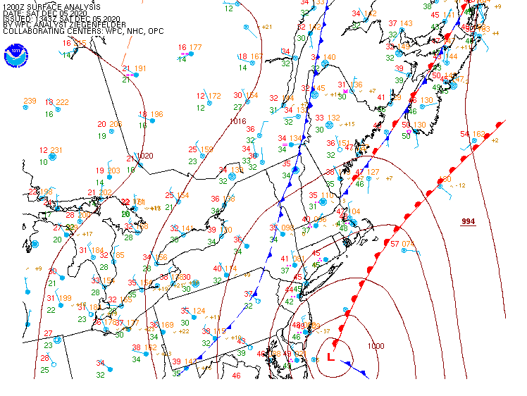
Low pressure is taking shape off the Mid-Atlantic coast this morning. Image provided by the Weather Prediction Center.

In the big picture, not a lot has changed this morning. Low pressure is just east of the Delmarva Peninsula this morning, and it will head northeastward today, intensifying rapidly as it passes close to or over Nantucket this afternoon, before heading into the Gulf of Maine tonight. Rain has overspread the region this morning, and has been heavy at times, while temperatures have dropped into the middle 30s to lower 40s. Across the higher elevations of Worcester County, the Monadnocks of southwestern New Hampshire, and the Berkshires, the rain has changed over to snow already.

Heavy rain is falling in many areas with a change to snow across the higher elevations of the interior. Loop provided by Weathertap.

Most of this is in line with the forecast we posted yesterday, the timing is just a little quicker. There still isn’t a lot of cold air to work with at the surface, but the storm is quite intense, and the heavier precipitation is dragging the cold air down from aloft. This will allow the rain to change to snow as the day goes on across much of the remainder of the region from west to east. Temperatures likely will stay in the lower 30s, so it will be a heavy, wet snow, and if the intensity lightens up, it could flip back to rain in spots. This could mean the difference between several inches of snow in one spot, and much less in a nearby location. Along the coast, where water temperatures are still in the 40s, it will take a little longer to flip to snow, thanks to the moderating influence of the marine air.

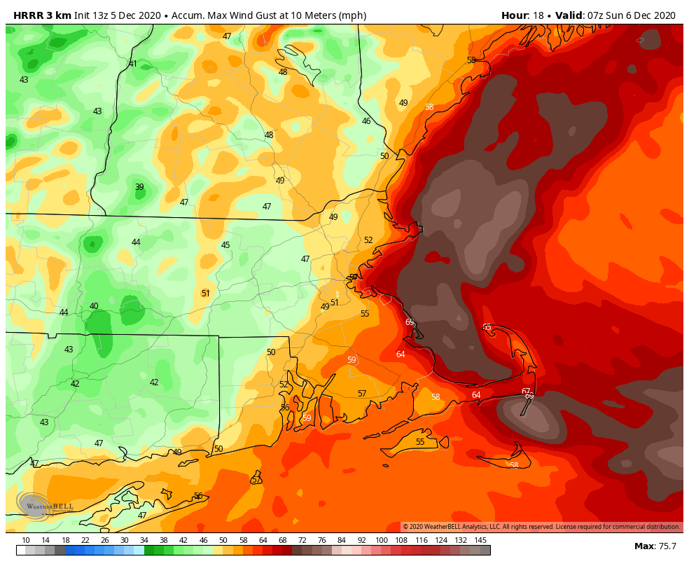
We’ll also have some strong winds to deal with later today, especially along the coastline. High Wind Warnings and Wind Advisories have been posted for parts of the region. Sustained winds of 20-30 mph and gusts to 50 mph or more are expected, mainly this afternoon and evening as the storm center passes near and just east of the region. Some gusts to 60 mph or more can’t be ruled out, especially across coastal Plymouth County along with Cape Cod and the Islands.

Strong winds are likely this afternoon and evening, especially near the coast. Image provided by WeatherBell.

Here’s where there is still some unknowns. There are likely to be bands of very heavy snow that develop as the system really gets cranked up. These could produce snowfall totals of 1-3 inches per hour. Where they set up is extremely difficult to predict in advance, and these bands could be as little as 5-10 miles wide. We’ve already had one band of very heavy rain setup from Worcester northeastward to the Merrimack Valley this morning. The western edge of this band changed to snow in the higher elevations in Worcester County. Similar bands are likely to form later today. Places just outside these bands could see significantly less snow these spots just a few miles down the road that get stuck under the bands. This obviously complicates the snowfall forecast.

Here’s our updated thoughts on the changeover timing:

Mid/Late morning: The higher terrain from central Massachusetts into southwestern New Hampshire
Late Morning/Midday: Southern New Hampshire
Midday/Early Afternoon: Merrimack Valley and New Hampshire Seacoast
Early/Mid Afternoon: MetroWest and the North Shore as well as Northern Rhode Island
Late Afternoon/Early Evening: I-95 corridor from Boston to Providence and Southeastern Massachusetts.

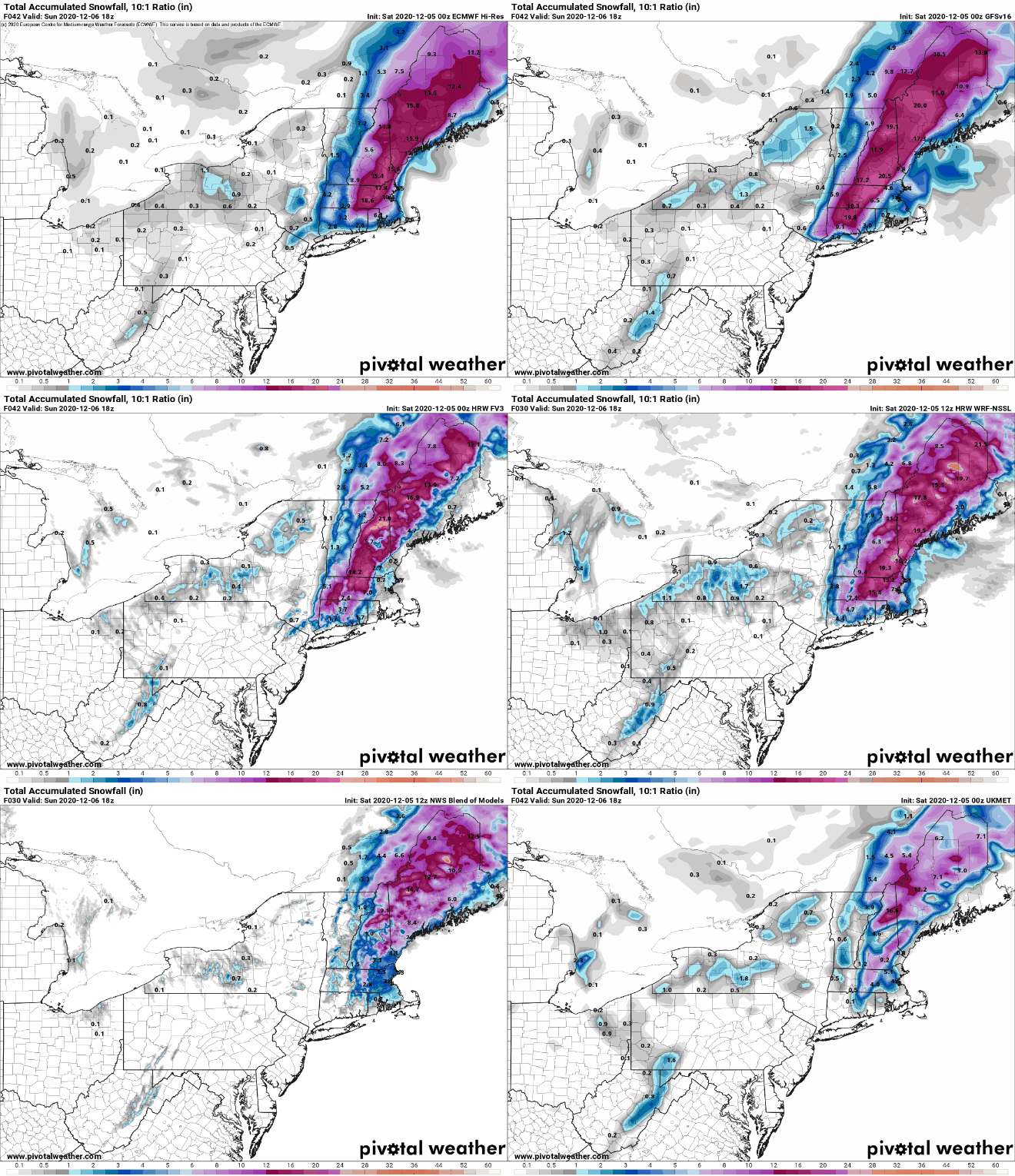
Everything should wind down and end by midnight as the storm moves into the Gulf of Maine and pulls away from the area. As for snowfall, there is still a wide range among many of the models, so forecast confidence is still below average.

Having said all of that, here’s our best estimate right now for snowfall:

Dusting (if that): Cape Cod and the Islands
1-3″: Southeastern Massachusetts and Southern Rhode Island
3-5″: I-95 corridor from Boston to Providence
4-7″: North Shore/New Hampshire Seacoast (heaviest inland)
5-9″: Merrimack Valley/Southern New Hampshire/MetroWest/Northern Rhode Island
6-12″: Worcester County/Southwestern New Hampshire


Some of the hills in Central Massachusetts and Southwestern New Hampshire, especially above 1000 feet, will likely see more than a foot.

The storm is already underway, but there is still a wide range in snowfall forecasts among the model. Images provided by Pivotal Weather.

Once the system passes by, we’ll have drier and cooler weather for the next several days. The only possible fly in the ointment is another system that is expected to pass well south and east of the region on Tuesday. Right now, it should be too far offshore to have much, if any, impact on our area, but we’ll keep an eye on it.

Stormy Saturday on Tap

The first snowstorm of meteorological winter is expected across at least part of the region on Saturday.

Low pressure is moving into Tennessee this afternoon, on its way toward the Northeast. Image provided by the Weather Prediction Center.

Low pressure moving into the Tennessee Valley this afternoon will cross the Appalachians tonight and move off the Mid-Atlantic coastline on Saturday. Ahead of it, rain will move into our area tonight, and it could be heavy Saturday morning. Given our long-term rainfall deficit, this is a good thing. However, some localized flooding is possible, especially in areas where the storm drains are covered or clogged by fallen leaves. This is the easy part of the forecast.

Rainfall totals of 1-2 inches are possible across much of the area from this storm. Image provided by Weathermodels.com

As the system moves northeastward, an upper-level disturbance will drop southeastward from Canada. This disturbance and the system to the south will eventually phase, resulting in a fairly strong storm system off the East Coast. There is still some question to the exact track the system takes, but it will likely pass close to or just south of Cape Cod and the Islands. As the system intensifies, it will generate some strong winds, especially along the coast south of Boston. High Wind Watches have been posted along the coast in this area, where sustained winds of 25-35 mph are expected, with some gusts to 50 mph or more possible.

Wind gusts of 50 mph or higher are possible along the coast late Saturday and Saturday night. Image provided by WeatherBell.

As the storm passes by our longitude, it will turn winds from the northeast to the north and eventually northwest. This will help bring colder air down from the north. The airmass to the north isn’t that cold by December standards, but temperatures will drop below freezing, which will allow for the rain to change over to snow from northwest to southeast as the low passes by. The exact track of the storm will determine exactly where the rain/snow line ends up. A track farther to the north and west results in less snow to the south and east.

The models still have a wide variety of ideas for how much snow is expected and where it will fall. Images provided by Pivotal Weather.

When that changeover occurs also will have a big impact on the snowfall amounts. Right now, here’s our thoughts on the changeover timing:

Late morning: The higher terrain from central Massachusetts into southwestern New Hampshire
Midday/Early Afternoon: Southern New Hampshire
Early/Mid Afternoon: Merrimack Valley and New Hampshire Seacoast
Late Afternoon: MetroWest and the North Shore as well as Northern Rhode Island
Early Evening: I-95 corridor from Boston to Providence and parts of Southeastern Massachusetts.

Everything should wind down and end by midnight as the storm moves into the Gulf of Maine and pulls away from the area.

Beyond the timing and track issues, we have one more thing that complicates the snowfall forecast. As the system gets cranked up, bands of very heavy snow will develop. Some of these bands may produce 1-2 inches of snow in an hour. Exactly where those bands set up is nearly impossible to determine in advance, and even trying to figure out a general area for them is tough, because part of it will depend on the track of the system.

Having said all of that, here’s our best estimate right now for snowfall:

Dusting (if that): Cape Cod and the Islands
1-2″: Southeastern Massachusetts and Southern Rhode Island
2-4″: I-95 corridor from Boston to Providence
3-5″: Northern Rhode Island/MetroWest/North Shore/New Hampshire Seacoast
4-7″: Merrimack Valley/Southern New Hampshire
5-9″: Worcester County/Southwestern New Hampshire

Obviously this is a low-confidence forecast, based on all of the factors above, but it’s our best guess at the moment. If there’s any significant changes, we may do another quick update Saturday morning/early afternoon.

The next few days after the storm look calmer, but another system will develop off the East Coast on Tuesday. Right now, it looks like it will stay too far south and east to have any impacts here, but we’ll keep an eye on it.

Weekend Outlook: December 4-7, 2020

It looks like we’ve got some snow coming in this weekend for at least part of the region, but that’s only part of a complex forecast for the next few days.

High pressure will slide offshore later today and tonight while clouds start to stream in ahead of a cold front. That front may produce a few showers on Friday, but most of us will just see some clouds as the front moves through. However, this will set the stage for the next storm.

Enjoy the mild weather on Friday, because changes are coming. Image provided by Weathermodels.com

Low pressure currently near the Louisiana coastline will head northeastward tonight, moving up the Appalachians on Friday, then off the Mid-Atlantic coastline on Saturday. At the same time, an upper-level disturbance in Canada will dive southeastward. As these two systems meet up or “phase”, they will create a strengthening low pressure system. The track of that low will determine several things, but the two main ones are how much precipitation will fall, and whether it will be rain or snow. Most of the models bring the storm near Cape Cod or just south of it, but there are others that bring it across southeastern Massachusetts. The farther north and west the low travels, the farther north and west the rain/snow line ends up.

There are still some significant differences among the models for the weekend storm. Images provided by Pivotal Weather

Before we get too far ahead of ourselves, let’s get to what we are fairly sure about. Rain will develop across the region early Saturday morning, and may fall heavy at times during the day on Saturday. This will help put another dent in our long-term rainfall deficit. As the low passes by, northerly winds will bring cooler air into the region. There’s not a lot of “cold” air to begin with, but temperatures will likely drop to near or below freezing, which will allow for a changeover to snow, at least north and west of Boston. That changeover is likely to occur Saturday night, but at least one model has it change over much earlier – during the afternoon. Others only have the changeover occur as the precipitation winds down and ends Sunday morning, and at least one other doesn’t have it changeover at all. Obviously when that changeover occurs will have an impact on how much snow (if any) accumulates.

Whether it’s all rain or rain to snow, this will be another heavy precipitation producer. Image provided by WeatherBell.

Right now, we’re expecting a change to snow from northwest to southeast Saturday evening and night, with everything winding down around daybreak Sunday. The snow could be heavy at times during Saturday evening, but should taper off at night as the system starts to pull away. Several inches could accumulate well north and west of Boston, but this is still a bit uncertain. We’re not going to forecast any amounts yet, as there’s not enough confidence yet to come up with specific amounts. We’ll do another blog post just on the storm tomorrow, and at that point we’ll have a specific snowfall forecast.

Skies should start to clear out Sunday afternoon as gusty west to northwest winds will bring drier air in behind the storm. High pressure will start to build in on Monday, but with an upper-level low pressure system moving through, we’ll still have some clouds, and a few rain or snow showers are possible.

Thursday night: Becoming mostly cloudy. Low 32-39.

Friday: Mostly cloudy, becoming breezy, chance for a few showers, mainly south of the Mass Pike during the afternoon. High 49-56.
Friday night: Cloudy with some showers developing. Low 35-42.

Saturday: Cloudy and windy with rain, heavy at times, changing to snow from central Massachusetts into southern New Hampshire late in the day. High 39-46 early (47-54 across Cape Cod and the Islands), then temperatures drop during the afternoon.

Saturday night: Cloudy and windy with rain changing to snow from northwest to southeast before tapering off and ending toward daybreak. Low 25-32, a little milder across Cape Cod and the Islands.

Sunday: A few lingering rain or snow showers early, then clearing in the afternoon, breezy. High 33-40.

Sunday night: Clear to partly cloudy. Low 19-26.

Monday: A mix of sun and clouds, slight chance for a rain or snow shower. High 32-39.

Weekly Outlook: November 30 – December 6, 2020

It won’t feel like the last day of November as we start the week on a windy, warm, and wet note.

A strong storm system will move up the Appalachians today, passing west of the region. This will allow unseasonably mild air into the area on gusty south to southeast winds. Sustained winds of 25-35 mph are expected, with some gusts of 50-60 mph (or higher) possible, especially near the coast. Temperatures will get well into the 50s across the region today, with many areas, especially in eastern Massachusetts possibly topping 60 by late in the day. The warm weather will be accompanied by rain, some of which may be heavy at times this afternoon and evening. A few thunderstorms are possible as well. By the time everything winds down at night, much of the region will have received 1-2 inches of rain, with some heavier amounts possible.

Heavy rain is expected across much of the region today. Image provided by Weathermodels.com

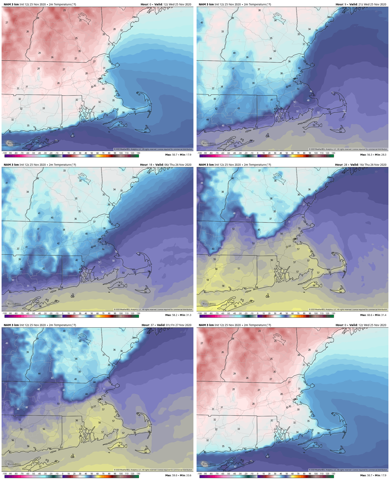
As the system moves into southeastern Canada on Tuesday, it will drag a cold front across the region. The day will start off mild, with temperatures in the upper 50s and 60s during the morning, but they’ll drop during the afternoon behind the front. A few more showers are also possible, but nothing as heavy as what we’re expecting today.

The NAM model shows the warm air move in today, remain in place into Tuesday morning, then colder air moves in Tuesday afternoon and night. Loop provided by WeatherBell.

By Wednesday, an upper-level low pressure system will move into the Northeast and southeastern Canada, bringing much cooler air in, though it will still be close to normal for early December. We’ll still have plenty of clouds around, and a pop-up shower or two can’t be ruled out, maybe even a snow flurry. High pressure then builds in for Thursday with sunshine. Clouds return Thursday night and Friday along with milder weather ahead of the next storm system.

Next weekend looks unsettled, but pinning down specifics at this point is an effort in futility. The models have performed relatively poorly beyond a few days lately, and there are significant differences in their solutions for next weekend as well. For now, we’ll just go with unsettled conditions, and the chance for some rain both Saturday and Sunday, but there is a possibility that the entire weekend won’t be unsettled. There’s also the possibility that all of the precipitation that falls wouldn’t be just rain. It will be early December, so this shouldn’t be a big surprise. We hope to have much more clarity on this when we write our Weekend Outlook on Thursday.

The models have no idea what to do with a potential storm next weekend. Image provided by Pivotal Weather.

Monday: Cloudy and becoming windy with rain, possibly heavy at times, maybe a thunderstorm as well. High 55-62.

Monday night: Mostly cloudy with diminishing winds, showers taper off toward midnight. Temperatures hold steady overnight.

Tuesday: More clouds than sun, breezy, chance for a few more showers. High 56-63 early, then temperatures drop in the afternoon.

Tuesday night: Becoming clear to partly cloudy. Low 31-38.

Wednesday: Intervals of clouds and sunshine, breezy, slight chance for a sprinkle or flurry. High 39-46.

Thursday: Mostly sunny, some high clouds may start to stream in late in the day. High 41-48.

Friday: Mostly cloudy, showers possible late in the day. High 47-54.

Saturday: Mostly cloudy and breezy with a chance of rain. High 43-50.

Sunday: Mostly cloudy and breezy with a chance of rain. High 42-49.

Stormy Weather Ahead for the East

A rather potent storm system will bring a variety of weather to the eastern third of the United States over the next few days.

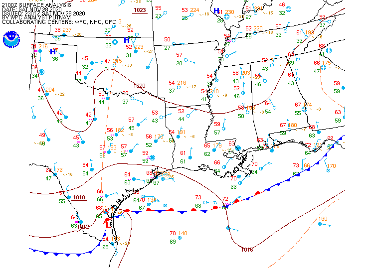
Low pressure is developing along a frontal system in southern Texas this evening. Image provided by the Weather Prediction Center.

Low pressure developed along a frontal system in southern Texas on Saturday, and it will slowly strengthen as it moves northeastward tonight and Sunday. As it strengthens, it will draw moisture northward from the Gulf of Mexico, while colder air continues to move southward behind the storm system. This will set the stage for a couple of rather active days across the Eastern third of the nation, with several different types of weather likely.

The GFS model shows the progression of the storm over the next few days. Loop provided by Tropical Tidbits.

The biggest threat initially will be severe weather. As the warm, moist air flows northward from the Gulf of Mexico and clashes with the colder air moving in behind the storm, strong to severe thunderstorms are possible. A few storms are possible overnight in parts of Texas and Louisiana, but the threat will shift into the Gulf Coast on Sunday, parts of the Southeast and the Carolinas Sunday night, and parts of the East Coast from Florida to the Mid-Atlantic states on Monday. Some of the stronger storms may produce heavy downpours, damaging winds, and possibly some tornadoes.

Strong to severe storms are possible from the Gulf Coast into the Carolinas on Sunday. Image provided by Pivotal Weather.

While severe weather is not common at this time of year, it is certainly not unheard of. In fact, Saturday marked the 32nd anniversary of one of the strongest tornadoes on record to hit North Carolina. On November 28, 1988, an F4 tornado tore an 84-mile path of damage across parts of North Carolina, including the city of Raleigh.

As the storm moves up the Appalachians it will bring unseasonably mild air to the East Coast, but also some heavy rainfall. Temperatures will be in the 60s and 70s across the Gulf Coast and Southeast on Sunday. By Monday, 60-degree readings will be possible as far north as southern New England, with some 70s into the Carolinas and parts of southern Virginia. The mild air may linger into Tuesday across parts of New England as well. While these temperatures are 10-20 degrees above normal, they will likely fall short of the record highs in most locations.

Monday will be a warm day by November standards up and down the East Coast. Image provided by WeatherBell.

The warm weather will be transported in by strong southerly winds ahead of the system. Sustained winds of 25-35 mph will be common up and down the East Coast. Many places could see wind gusts of 50-60 mph or stronger, which could lead to power outages as trees and wires come down.

Wind gusts in excess of 50 mph are possible across the East Coast ahead of the storm. Image provided by WeatherBell.

In addition to the warm weather, heavy rain is likely for much of the East. The warm, moist air being drawn northward from the Gulf of Mexico will be deposited up and down the East Coast later Sunday into Monday, and early Tuesday for parts of New England. Rainfall totals of 1-2 inches will be common, with some places possibly picking up 3 inches or more, especially in parts of eastern New England. While this will help put another significant dent in the long term drought that the region is experiencing, too much rain at once will likely lead to flooding in some areas.

Heavy rain is likely across the East Coast Monday into Tuesday. Image provided by Weathermodels.com

While all of this is going on ahead of the storm, a different scenario will be evolving on the storm’s back side. Colder air flowing southward from Canada will clash with the warm air, resulting in snow across parts of the Great Lakes and the Appalachians. The snow will be accompanied by gusty winds, lowering visibility in many locations, resulting in very hazardous driving conditions. While the snow won’t be exceptionally heavy, many places could receive upwards of 4-8 inches by the time everything winds down. Across the higher elevations of the Appalachians, even into the southern Appalachians, some heavier amounts are possible as well. As the systems gets caught under an upper-level low pressure system in southeastern Canada, it may produce some lake-effect snow into mid-week downwind of Lakes Erie and Ontario.

Accumulating snow is expected behind the storm system. Image provided by Pivotal Weather.

Once this system pulls away, things will quiet down across the East for a few days, but there are signs that another system could impact parts of the East next weekend.

Thanksgiving Weekend Outlook: November 26-30, 2020

A wet Thanksgiving day appears likely, but much of the rest of the weekend looks dry at this point.

We’ve got plenty of clouds around today, well ahead of a low pressure system moving towards the Great Lakes. As that system continues eastward, we’ll see showers moving in tonight. While temperatures will be fairly mild for most of us, some chilly air is hanging around this afternoon from Southern New Hampshire into north-central Massachusetts and the Merrimack valley. While temperatures are mainly above freezing, a few spots could drop back close to freezing this evening, which may result in a few slippery spots as the rain moves in tonight. Temperatures should gradually rise towards morning even in these areas.

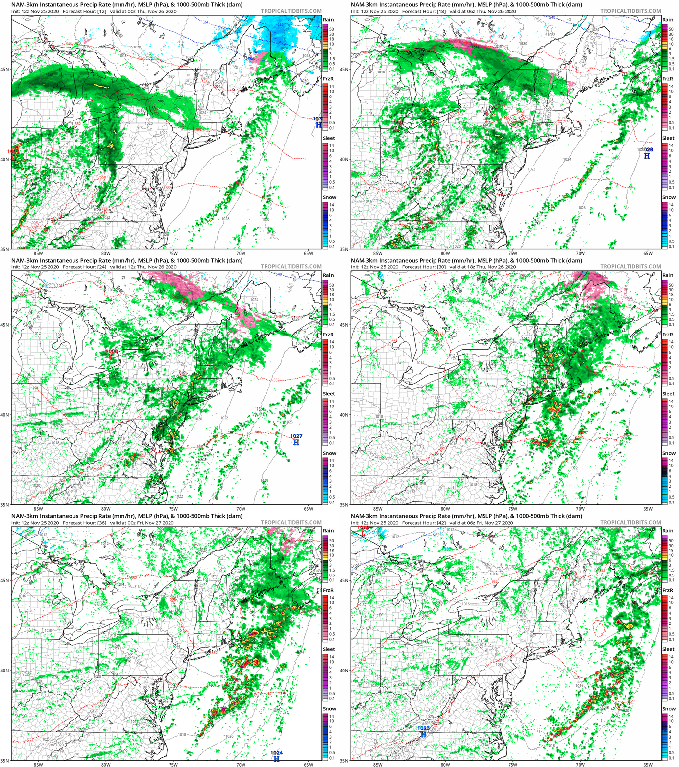
The milder air may never actually make it into Southern New Hampshire on Thanksgiving Day. Loop provided by WeatherBell.

Thanksgiving starts out with some rain, but there may be a bit of a lull around early afternoon as the initial batch of rain moves out. A cold front will be approaching from the west, and a secondary area of low pressure will ride up along it, bringing more rain in by late afternoon and evening. There may even be a rumble of thunder with the rain, mainly across southeastern Massachusetts. Temperatures may remain on the cool side from southern New Hampshire into parts of interior Massachusetts, but across eastern Massachusetts, much milder air is expected, with some places, especially near the South Coast, possibly getting close to 60. Everything finally moves offshore during the evening, but skies remain cloudy overnight, with some patchy fog possible as there will be plenty of low-level moisture in place across the area.

The NAM model shows the progression of the storm tonight and Thursday. Loop provided by Tropical Tidbits

Friday likely features plenty of clouds but only a slight chance for a shower or two as an upper-level disturbance moves through, but temperatures should be mild in most places, with highs generally reaching the 50s. We finally start to clear out Friday night, with high pressure building in for the weekend with sunshine and cooler temperatures.

Monday will feature more changes. Another storm system will head towards the Great Lakes, sending some more clouds into the region. Right now, it looks like this could be a significant rain-maker for Monday night into Tuesday (and possibly Wednesday). This will help put a big dent into our long term rainfall deficit. This may also turn out to be a significant storm system for portions of the Midwest and East Coast. If this is still looking that way by Friday or Saturday, we’ll likely write up a special blog post about it.

Between Thursday’s storm and the one early next week, much of the region could receive some significant rainfall. Image provided by Weathermodels.com

Wednesday night: Cloudy with showers developing after midnight. Low 33-40 in southern New Hampshire and north-central Massachusetts, 41-48 elsewhere.

Thanksgiving Day: Periods of rain and showers, maybe even a rumble of thunder. High 45-52 in southern New Hampshire and north-central Massachusetts, 53-60 elsewhere.

Thursday night: Showers end in the evening, otherwise partly to mostly cloudy with some patchy fog likely. Low 36-43 in southern New Hampshire and the Merrimack Valley, 44-51 elsewhere.

Friday: Intervals of clouds and sun, just a slight chance for a late-day shower. High 52-59.

Friday night: Becoming partly cloudy to clear. Low 36-43.

Saturday: Partly to mostly sunny. High 46-53.

Saturday night: Clear skies. Low 28-35.

Sunday: Sunshine. Lots of sunshine. High 44-51.

Sunday night: Clear during the evening, clouds start to move in overnight. Low 29-36.

Monday: Becoming cloudy High 51-58.

Weekly Outlook: November 23-29, 2020

We’re going to put a few dents in that drought this week, as we’ll have a few storms systems to contend with, but it looks like they’ll be mostly rain, with one of them on Thanksgiving Day. Notice that we said “mostly rain”, as we could have some issues Wednesday night, especially in southern New Hampshire.

We’ll get some relief for the drought this week thanks to at least 2 storm systems. Image provided by the National Drought Mitigation Center.

We start the week off on a wet note as low pressure passes north and west of the region, providing us with a rainy start to the day. Temperatures will be on the mild side this morning, but don’t get used to it. A cold front will cross the region by early afternoon, bringing an end to the rain, but behind it, gusty winds will usher much cooler air back in as skies clear out, leading to a chilly night tonight.

The NAM model shows the warm air ahead of the cold front quickly replaced by much cooler air behind the front this afternoon and evening. Loop provided by WeatherBell.

High pressure builds in for Tuesday with dry and cool conditions. It will still be breezy early on as today’s low pressure system continues to pull away, but winds should die down during the afternoon as the high continues to build in. With clear skies and light winds Tuesday night, we’ll have another chilly night, but some high clouds may start to move in late at night, which would prevent temperatures from tumbling too much. Those high clouds will be in advance of a warm front that will approach the region on Wednesday, possibly accompanied by a few showers. This could set up a tricky situation during the late afternoon and evening across southern New Hampshire and possibly the Merrimack Valley. The warm front may have trouble moving northward during the day, and with chilly air in place and a little bit of precipitation possible, it could fall in the form of a little freezing drizzle, especially in southern New Hampshire, which could result in some slippery conditions Wednesday evening. This is a scenario that happens quite often during the fall and winter, and the models usually handle it poorly, or miss it completely, as they usually overestimate how quickly the warmer air will move in and how far north it can get. We’ve seen the models blow this type of forecast countless times, and the setup is there for it to happen again.

At least one model shows the potential for some icy conditions in southern New Hampshire Wednesday night. Image provided by Pivotal Weather.

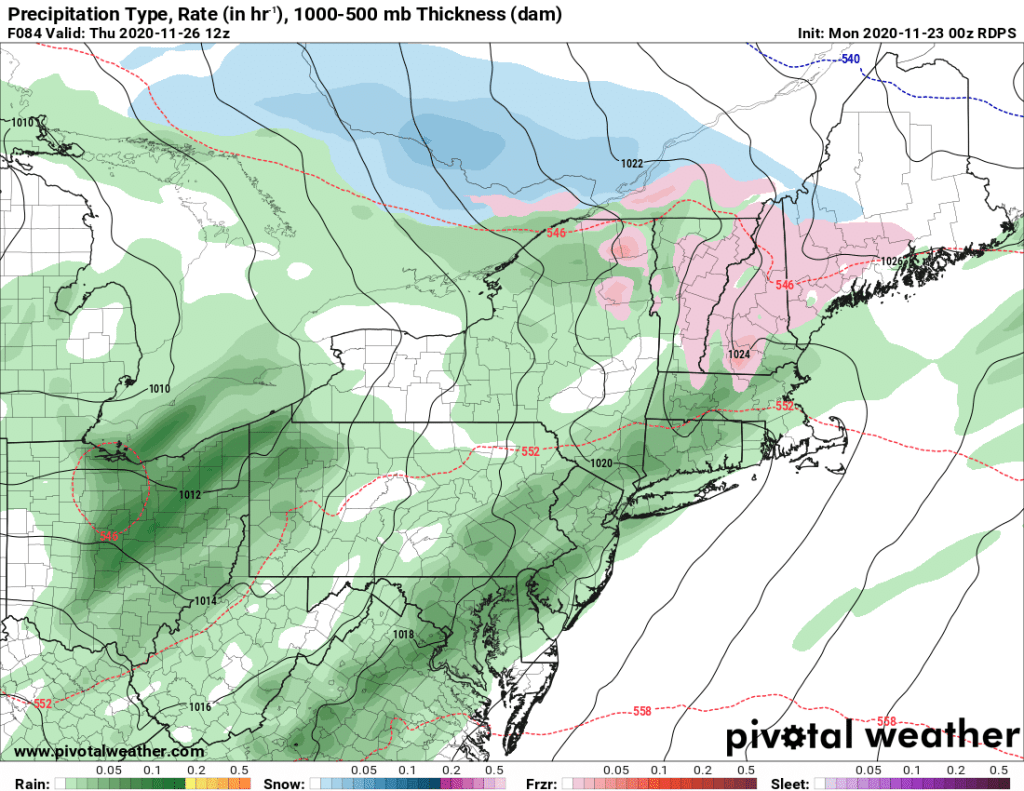
That next system brings in more rain for Thanksgiving Day. Right now, it looks like most of the rain will be in the morning, but there are still some timing differences among the models, so showers may linger into the afternoon, and possibly even the evening. High pressure builds in behind that system with drier and cooler weather again on Friday, though a few showers are possible as an upper-level disturbance moves across the region.

Next weekend also has some questions, as the models all have differing solutions. Some models want to bring a weak system through late Saturday with some showers, then have high pressure build back in on Sunday, with another system potentially bringing in some rain next Monday. Others keep high pressure in control for much of the weekend, but have the next system move in at some point late Sunday or Sunday night. They also differ on the track of that system, which has significant implications for temperatures on Sunday. So, our forecast for next weekend is very-low confidence at this point, and may end up significantly different when we issue our weekend outlook (which will be on Wednesday this week instead of the normal Thursday).

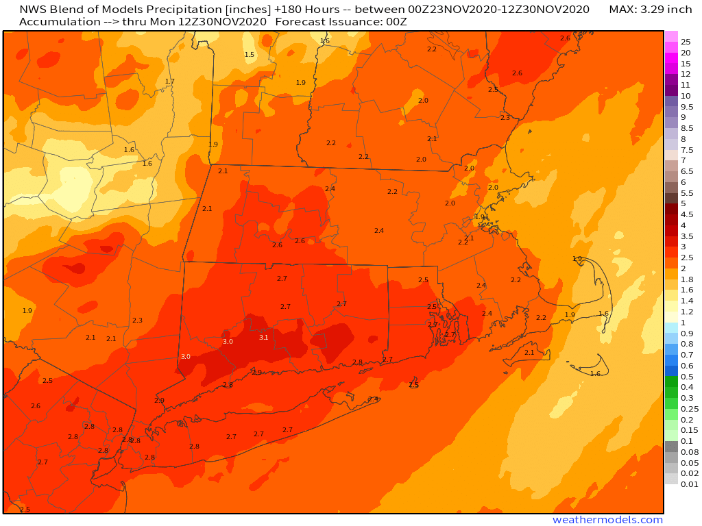
The potential exists for a decent amount of rain around here between now and next Monday. Image provided by Weathermodels.com

Monday: Breezy with showers and some steadier rain this morning, possibly a rumble of thunder as well, ending by early afternoon, then skies start to clear out by evening. High 54-61 in the morning, but temperatures may drop pretty quickly during the afternoon.

Monday night: Clear to partly cloudy and breezy. Low 27-34.

Tuesday: Sunshine and a few clouds, breezy in the morning. High 37-44.

Tuesday night: Clear during the evening, high clouds start to move in after midnight. Low 19-26.

Wednesday: Becoming partly to mostly cloudy, chance for a shower or two, possibly some freezing drizzle across southern New Hampshire during the evening or at night. High 36-43 north of the Mass Pike, 44-51 south of the Pike.

Thanksgiving: Cloudy with periods of rain and showers, ending during the afternoon. High 42-49 in southern New Hampshire and the Merrimack Valley, 50-57 elsewhere.

Friday: Partly sunny, slight chance for a shower. High 49-56.
Saturday: A mix of sun and clouds. High 49-56.

Sunday: A sunny start, clouds move in during the afternoon. High 45-52.

Weekend Outlook: November 20-23, 2020

A warming trend is on the way for the weekend, but possibly some rain as well.

After a rather chilly start to the day, temperatures have moderated as high pressure moves offshore. Temperatures will continue to warm up into Friday and Saturday, though as the high moves off to our north and east, winds will shift into the northeast, allowing cooler air to slide back in later on Saturday and into Sunday.

Temperatures bottomed out in the middle teens to middlle 20s across most of the region this morning. Image provided by NOAA.

By later on Sunday, a warm front will move toward the region. Whether or not it makes it all the way through is still a question mark, but parts of the region, especially south of Boston, should see milder air move in for a while on Monday. The milder air will be preceded by some showers Sunday night and early Monday ahead of a cold front. While this won’t be drought-busting rainfall, every little bit helps at this point.

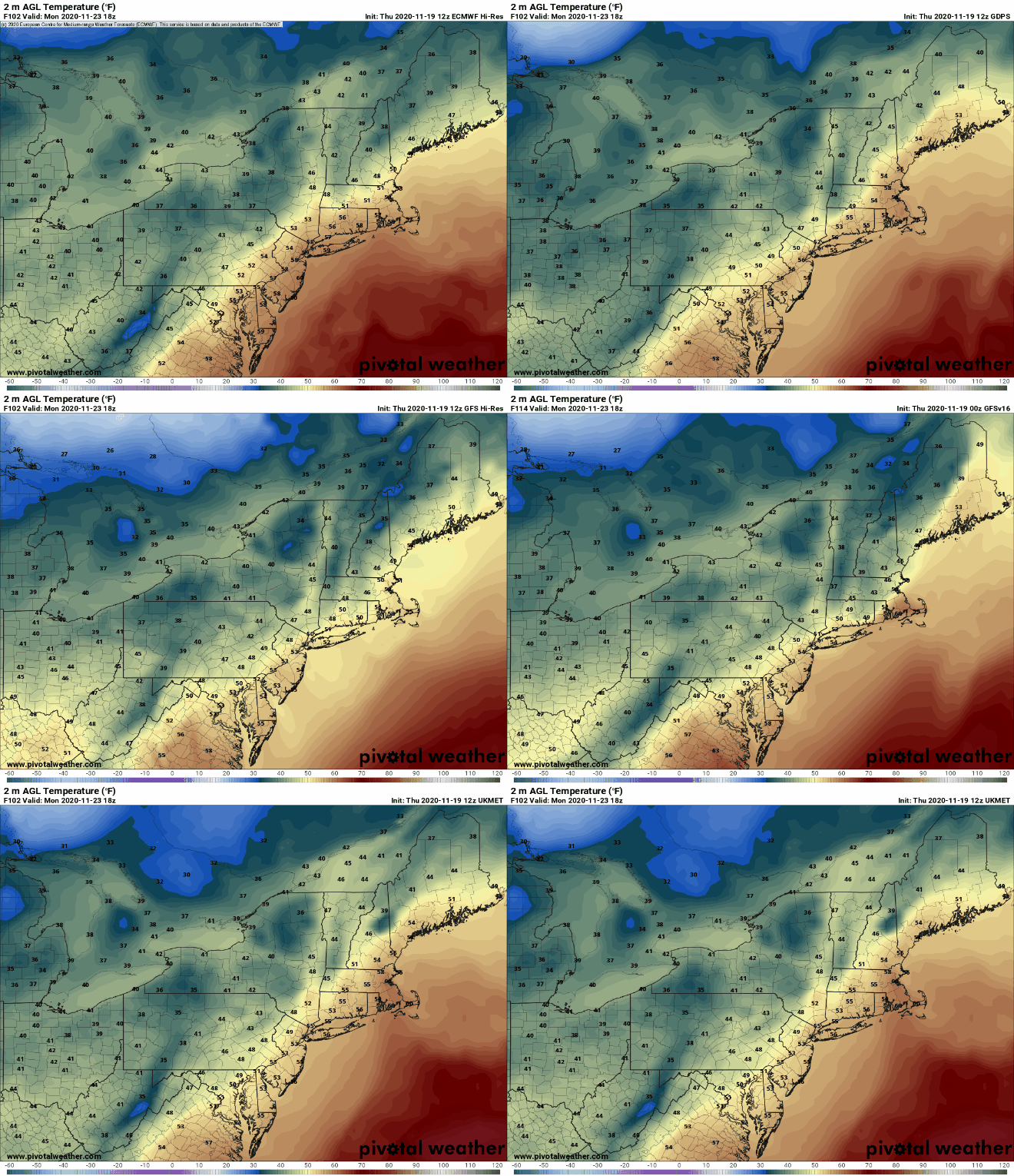
The models don’t agree on how far north the warm air will get on Monday. Images provided by Pivotal Weather.

Thursday night: Partly cloudy. Low 35-42.

Friday: A mix of sun and clouds, breezy. High 53-60.

Friday night: Clear to partly cloudy. Low 39-46.

Saturday: Partly sunny. High 52-59.

Saturday night: Clear to partly cloudy, some low clouds, fog, and drizzle are possible along the coast. Low 27-34.

Sunday: Becoming mostly cloudy. High 42-49.

Sunday night: Showers likely, maybe mixed with a little sleet or wet snow at the start up into central New Hampshire. Low 34-41.

Monday: Showers end early, skies may clear out in the afternoon, breezy. High 53-60, possibly a little cooler in southern New Hampshire.

Weekly Outlook: November 16-22, 2020

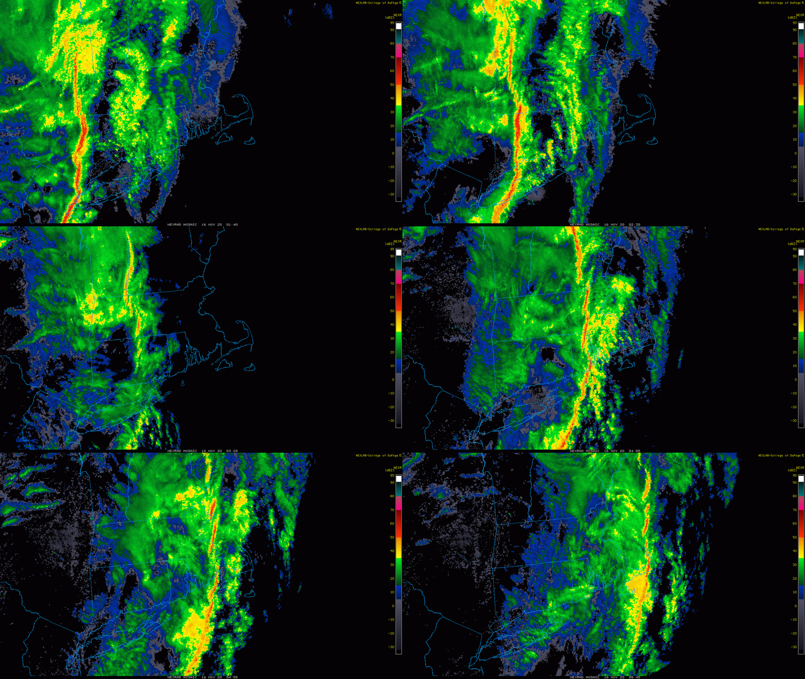
After last night’s squall line, conditions will be significantly quieter for most of this week.

That was a fairly impressive squall line for mid-November that came through last evening. Loop provided by the Collegbe of DuPage

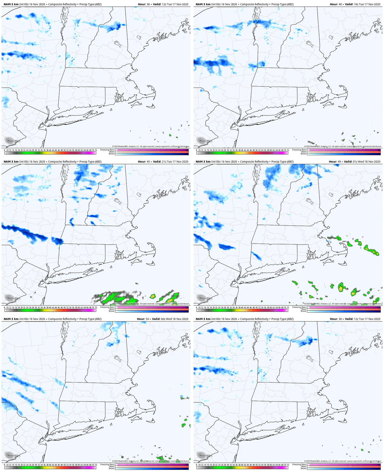
High pressure builds into the region today with breezy and cooler conditions as a cold front continues to push offshore. We’ll have some clouds popping up in the afternoon as cooler air moves in aloft, but we should remain dry. Another cold front will move through late Tuesday. This one may produce a few rain or snow showers, but for most of us it will pass through with little fanfare.

A few rain or snow showers are possible on Tuesday as a cold front moves through. Loop provided by WeatherBell.

Behind that front, much colder air will settle in for Wednesday. Temperatures likely won’t reach 40, with wind chills in the 20s or even upper teens. As winds die down Wednesday night, low temperatures will drop into the teens across much of the region. Thursday will still be chilly, but with high pressure sliding offshore, temperatures will start to moderate a bit. The moderating trend continues into the weekend, as temperatures climb back above normal for the latter half of November.

Wind chills will be in the upper teens and 20s Wednesday afternoon. Image provided by WeatherBell.

Monday: Sunshine and some afternoon clouds, breezy. High 45-52.

Monday night: Clear skies. Low 29-36.

Tuesday: Intervals of clouds and sunshine, chance for a late-day rain or snow shower. High 40-47.

Tuesday night: Clearing, colder. Low 21-28.

Wednesday: Mostly sunny, breezy, and chilly. High 29-36.

Thursday: Partly sunny, breezy. High 39-46.

Friday: A mix of sun and clouds. High 52-59.

Saturday: Partly sunny. High 51-58.

Sunday: Intervals of clouds and sun. High 49-56.