Our storm is well underway, and we’ve got some changes to the forecast.
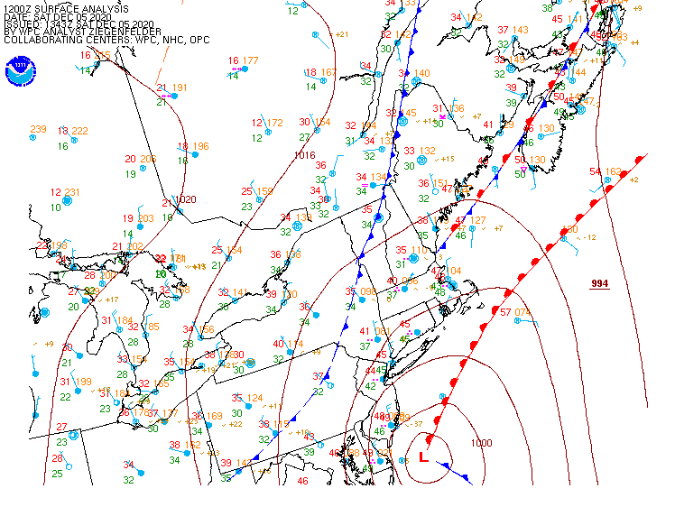
In the big picture, not a lot has changed this morning. Low pressure is just east of the Delmarva Peninsula this morning, and it will head northeastward today, intensifying rapidly as it passes close to or over Nantucket this afternoon, before heading into the Gulf of Maine tonight. Rain has overspread the region this morning, and has been heavy at times, while temperatures have dropped into the middle 30s to lower 40s. Across the higher elevations of Worcester County, the Monadnocks of southwestern New Hampshire, and the Berkshires, the rain has changed over to snow already.

Most of this is in line with the forecast we posted yesterday, the timing is just a little quicker. There still isn’t a lot of cold air to work with at the surface, but the storm is quite intense, and the heavier precipitation is dragging the cold air down from aloft. This will allow the rain to change to snow as the day goes on across much of the remainder of the region from west to east. Temperatures likely will stay in the lower 30s, so it will be a heavy, wet snow, and if the intensity lightens up, it could flip back to rain in spots. This could mean the difference between several inches of snow in one spot, and much less in a nearby location. Along the coast, where water temperatures are still in the 40s, it will take a little longer to flip to snow, thanks to the moderating influence of the marine air.
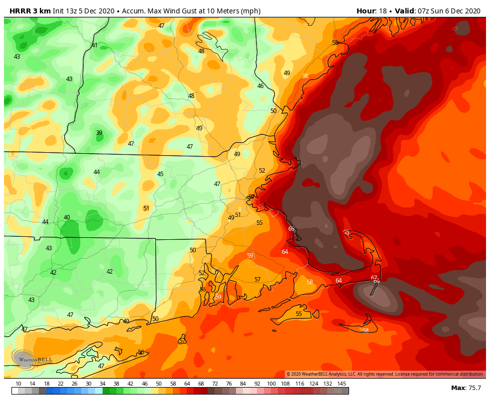
We’ll also have some strong winds to deal with later today, especially along the coastline. High Wind Warnings and Wind Advisories have been posted for parts of the region. Sustained winds of 20-30 mph and gusts to 50 mph or more are expected, mainly this afternoon and evening as the storm center passes near and just east of the region. Some gusts to 60 mph or more can’t be ruled out, especially across coastal Plymouth County along with Cape Cod and the Islands.
Here’s where there is still some unknowns. There are likely to be bands of very heavy snow that develop as the system really gets cranked up. These could produce snowfall totals of 1-3 inches per hour. Where they set up is extremely difficult to predict in advance, and these bands could be as little as 5-10 miles wide. We’ve already had one band of very heavy rain setup from Worcester northeastward to the Merrimack Valley this morning. The western edge of this band changed to snow in the higher elevations in Worcester County. Similar bands are likely to form later today. Places just outside these bands could see significantly less snow these spots just a few miles down the road that get stuck under the bands. This obviously complicates the snowfall forecast.
Here’s our updated thoughts on the changeover timing:
Mid/Late morning: The higher terrain from central Massachusetts into southwestern New Hampshire
Late Morning/Midday: Southern New Hampshire
Midday/Early Afternoon: Merrimack Valley and New Hampshire Seacoast
Early/Mid Afternoon: MetroWest and the North Shore as well as Northern Rhode Island
Late Afternoon/Early Evening: I-95 corridor from Boston to Providence and Southeastern Massachusetts.
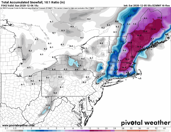
Everything should wind down and end by midnight as the storm moves into the Gulf of Maine and pulls away from the area. As for snowfall, there is still a wide range among many of the models, so forecast confidence is still below average.
Having said all of that, here’s our best estimate right now for snowfall:
Dusting (if that): Cape Cod and the Islands
1-3″: Southeastern Massachusetts and Southern Rhode Island
3-5″: I-95 corridor from Boston to Providence
4-7″: North Shore/New Hampshire Seacoast (heaviest inland)
5-9″: Merrimack Valley/Southern New Hampshire/MetroWest/Northern Rhode Island
6-12″: Worcester County/Southwestern New Hampshire
Some of the hills in Central Massachusetts and Southwestern New Hampshire, especially above 1000 feet, will likely see more than a foot.
Once the system passes by, we’ll have drier and cooler weather for the next several days. The only possible fly in the ointment is another system that is expected to pass well south and east of the region on Tuesday. Right now, it should be too far offshore to have much, if any, impact on our area, but we’ll keep an eye on it.
