Quiet weather is expected for much of the upcoming week once again, but that doesn’t mean the entire week will be storm-free.
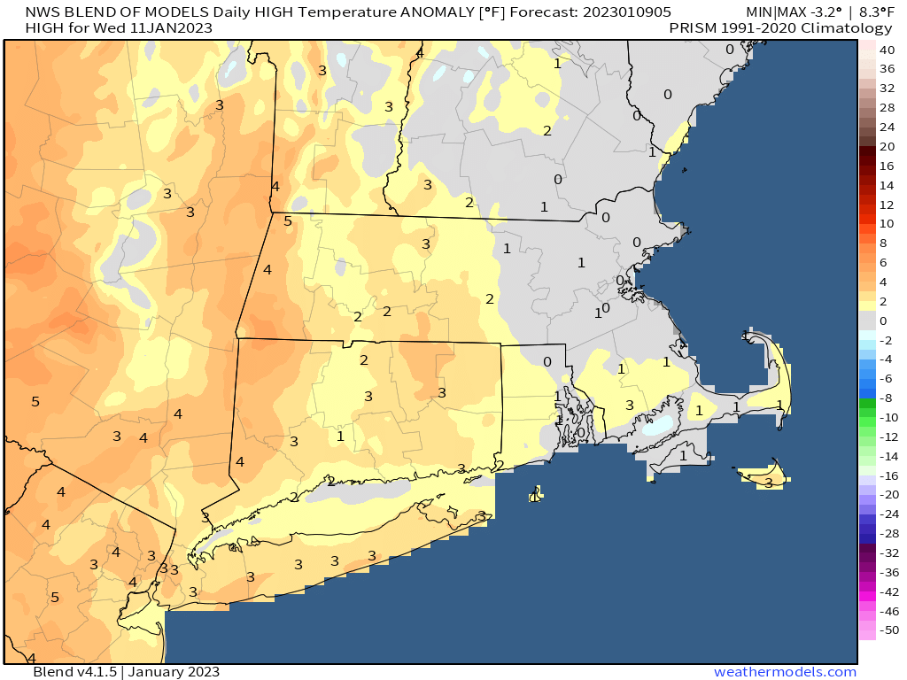
By mid-week, temperatures will be fairly close to normal for mid-January. Image provided by Weathermodels.com
We start the week off with a very weak system passing by to the south. It spread some clouds in, with a few rain or snow showers possible across southeastern Massachusetts and the Cape and the Islands this morning. We’ll start to clear out in the afternoon as high pressure starts to build in. Some sunshine and seasonably cool temperatures are expected on Tuesday, and even into Wednesday, but during the Wednesday we’ll see some clouds start to move in as low pressure begins heading toward the Midwest. There’s some disagreement among the models on the evolution of this storm, but at this point, it looks likely to be mainly a rainstorm around here, with only a little wet snow possible on the front end of the storm across parts of southern New Hampshire. There’s also some disagreement on the timing of the storm, but right now at least, it looks like it’ll be late Thursday into Friday. There’s some disagreement for Saturday as well. Some of the models have a secondary storm move up the cast, possibly bringing in some more rain or snow, others just have an upper-level disturbance move through with some clouds and a few rain or snow showers. We’re going to lean toward the drier scenario for now, but that can obviously change. High pressure builds in for Sunday.
There’s quite the range of scenarios on Saturday depending on which model you look at. Images provided by Pivotal Weather.
Monday: Morning clouds, maybe a rain or snow shower across Southeastern Massachusetts and the Cape and Islands, clearing in the afternoon. High 36-43.
Monday night: Clear to partly cloudy. Low 23-30.
Tuesday: A mix of sun and clouds. High 34-41.
Tuesday night: Partly cloudy. Low 18-25.
Wednesday: Partly sunny, clouds thicken up late in the day. High 33-40.
Thursday: Cloudy with rain likely late in the day and at night, possibly starting as some wet snow across southern New Hampshire. High 37-44.
Friday: Rain tapers off to showers and ends. High 46-53.
Saturday: More clouds than sun, chance for a rain or snow shower. High 39-46.
The weather pattern will start to quiet down again this weekend, but not before some of us get some snow on Friday.
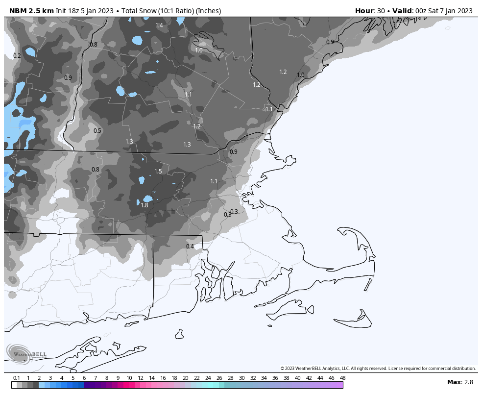
Drizzle and fog (and a little freezing drizzle) will gradually taper off tonight as a cold front continues to push offshore. An upper-level system quickly follows for Friday. With colder air in place, precipitation will be mainly in the form on snow north and west of Boston, while areas near the coast and south of Boston likely see mostly rain, with some snow mixed in, especially as everything winds down. Snow likely develops during the late morning hours and ends during the evening. It should be mostly light, but some bursts of moderate to perhaps heavy snow are possible. For accumulations, south and east of I-95 will have some slush at most. Areas north and west of I-95 are looking at a general 1-2″ with some spots possibly picking up 3-4″ if these heavier bursts do materialize. We’ll still have some clouds around on Saturday, then we should clear out for Sunday and Monday with seasonably chilly conditions expected.
Friday’s snow shouldn’t be a big deal, especially as you get closer to the coast. Image provided by WeatherBell.
Thursday night: Plenty of clouds, drizzle and fog linger, especially during the evening. Low 31-38.
Friday: Mostly cloudy, light snow developing north and west of I-95, rain south and east, possibly changing to snow late in the day. High 35-42.
Friday night: Snow and rain end in the evening, then skies become partly cloudy. Low 27-34.
Saturday: Intervals of clouds and sunshine. High 36-43.
This week will start and end with quiet weather, but in between will be interesting.
High pressure provides the region with dry and mild weather today, though not as mild as the past few days. Clouds will start to move in tonight ahead of a low pressure system moving into the nation’s midsection. A warm front will approach on Tuesday, with some light rain and showers likely ahead of it during the afternoon and evening. Much warmer air will move in behind the front for Tuesday night and Wednesday, but the question becomes – how far north does the front get before stalling out. South of the front, temperatures will get well into the 50s or even 60s on Wednesday, but to the north, it will stay in the 40s. At this point, it looks like the front should get north of the Mass Pike and to at least Route 2 and possibly the MA/NH border. Whether it gets farther than that is debatable, or if it even gets that far. Another round of showers is likely Wednesday afternoon and evening as a cold front approaches. The warm front will also begin dropping southward again as a backdoor cold front. Temperatures will drop rapidly once that passes, so timing it correctly will be critical to the forecast. Most of the models have it move through during the evening or at night, but some have it as early as mid-afternoon.
There are significant differences among the models as the how far north the warm air gets on Wednesday. Images provided by Pivotal Weather.
Once the cold front moves through and temperatures start dropping, we could see a change to freezing rain and sleet across the interior late Wednesday night into early Thursday. Another low pressure system passes south of the region later Thursday into early Friday, which may produce some snow across the area, with accumulations possible, especially across the interior. High pressure then builds in for the weekend with drier conditions and seasonably chilly temperatures.
A little snow is possible Thursday night and Friday morning. Image provided by WeatherBell.
Monday: A mix of sun and clouds. High 43-50.
Monday night: Clear skies through the evening, clouds increase overnight. Low 28-35.
Tuesday: Cloudy with light rain and showers developing. High 36-43 north of the Mass Pike, 44-51 south of the Pike.
Tuesday night: Cloudy with a few showers or some drizzle. Temperatures hold steady or rise overnight.
Wednesday: Cloudy, showers redevelop in the afternoon, possibly changing to freezing rain or snow overnight, mainly across southern New Hampshire. High 51-58, possibly much cooler across southern New Hampshire.
Thursday: Cloudy and breezy with some snow showers possible during the day, steadier light snow possible at night. High 37-44.
Friday: Cloudy with a chance for some light snow, mainly in the morning. High 34-41.
We’ve endured plenty of chilly Frist Night celebrations over the years around there. This year won’t be one of them.
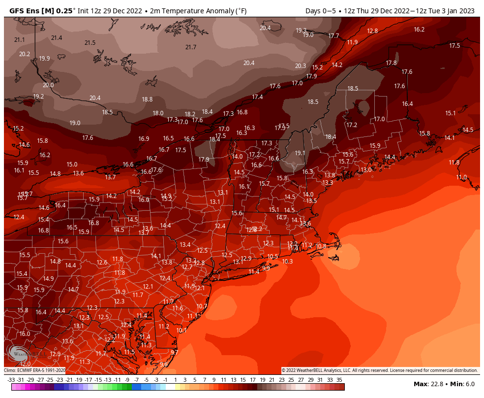
Temperatures will average 10-15 degrees normal over the next few days. Image provided by WeatherBell.
High pressure slides offshore tonight and Friday, with dry and mild conditions expected. Clouds start to stream in Friday night ahead of a low pressure system moving this way. Saturday will be another mild, albeit cloudy, day. Showers will develop toward evening, becoming a steady rain overnight. So, if you’re heading out to celebrate New Year’s Eve, bring a raincoat. The rain should come to an end New Year’s morning, then skies clear out during the afternoon as the low pulls away and high pressure builds back in. For Monday, we should have partly to mostly sunny skies and mild temperatures, perfect for viewing the Winter Classic at Fenway (not so perfect for the ice condition).
Weather shouldn’t be much of an issue for the Winter Classic on Monday. Image provided by Warner Brothers.
Thursday night: Clear to partly cloudy. Low 28-35.
Friday: Partly to mostly sunny and mild. High 48-55.
Friday night: Increasing clouds. Low 37-44.
Saturday: Cloudy with showers developing toward evening. High 51-58.
Saturday night: Periods of rain. Low 43-50.
Sunday: Showers end early, skies start to clear out in the afternoon. High 50-57.
The final week of 2022 will feature a warmup across the region.
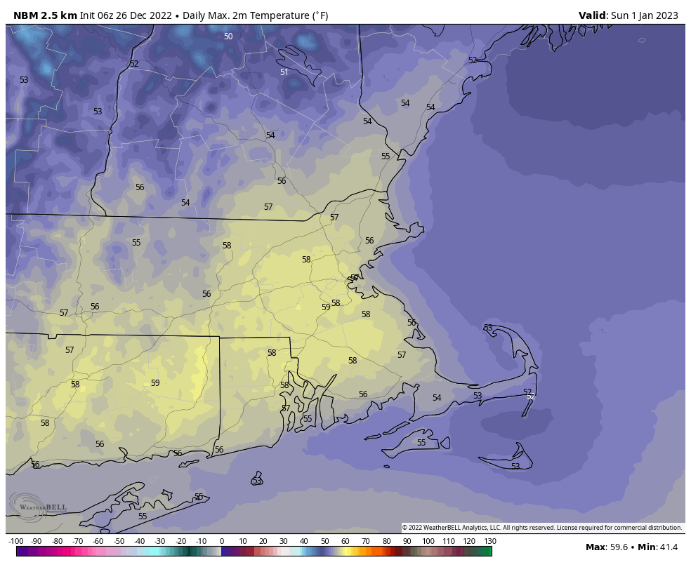
We start the week off with high pressure in control, keeping us chilly today. We’ll have sunshine in the morning, but clouds start to stream in during the afternoon as a weak disturbance moves toward the region. This may produce a few flurries tonight, but for the most part, we’ll remain dry. High pressure then builds in for Tuesday with clearing skies and temperatures remaining near or a little below normal for late December. The warmup begins on Wednesday, and continues into the weekend, with temperatures getting above normal, perhaps well above normal for New Years Eve and New Years Day, with highs well into the 50s or even near 60. A weak backdoor cold front may try to bring in some cooler weather on Friday, especially from the North Shore to the New Hampshire Seacoast, but this is looking less and less likely as time goes on. The dry weather will continue into Saturday morning, but unfortunately, low pressure will approach later or New Years Eve into New Years Day with some rain, especially on Sunday.
It looks like 2023 is going to start on a very mild note. Image provided by WeatherBell.
Monday: Morning sunshine begins to fade behind increasing and thickening afternoon clouds. High 26-33.
Monday night: Cloudy with a few flurries possible, some clearing develops late at night. Low 16-23.
Tuesday: Becoming mostly sunny. High 28-35.
Tuesday night: Clear to partly cloudy. Low 15-22.
Wednesday: Partly sunny, milder. High 34-41.
Thursday: A mix of sun and clouds. High 41-48.
Friday: Partly sunny and mild. High 47-54.
New Year’s Eve: Mostly cloudy, showers possible during the afternoon, becoming more likely at night. High 49-56.
There used to be a waterpark in Orlando named Wet n’ Wild. That could also describe our forecast for the next 24 hours.
A rather potent storm system is moving toward the Great Lakes, producing blizzard conditions across the Plains and Upper Midwest. Behind the storm, arctic air is plunging southward from Canada. How cold is this airmass? When the front goes through, some places have dropped 30-40 degrees in an hour. In Denver, the temperature dropped to -24 this morning, just 1 degree off of their all-time record low for December. Up in the Northwest Territories of Canada, RabbitKettle Lake dropped to -64 this morning. That’s actual temperature, not wind chill. The airmass will moderate significantly before reaching us, but some colder air is definitely on the way.
For the 3rd consecutive morning this week, #Mayo, YT has recorded a temp at or below -50°C. Meanwhile, #RabbitKettle, NT holds the title of coldest temperature in Canada of 2022 with this morning's -53.4°C. East of Hudson Bay on the other hand is above seasonal. @weathernetworkpic.twitter.com/RIqk2gPGmV
Rain will move in this evening, and could be heavy at times overnight into Friday morning. Winds will start to pick up tonight, and should really be cranking Friday morning and into the afternoon. Sustained winds of 15-30 mph are likely, with gusts in excess of 50 mph possible, especially along the coast and in the hills. With strong winds and astronomical high tides, some coastal flooding is expected, mainly with the morning high tide on Friday. The rain may taper off for a while around midday Friday, but the cold front moves in from the afternoon. Unlike most cold fronts, this one will be moving from southwest to northeast, and the colder air will come in on southwest winds, which normally brings in milder air to our area. Temperatures will rapidly drop once the front moves through, and while they won’t drop 30-40 degrees in an hour, a drop of 20-30 degrees over a couple of hours is certainly possible. A line of showers will accompany the front, and as the colder air moves in, these showers could change to snow before ending in the evening. As temperatures plunge, any surfaces that are still wet will rapidly freeze up during the evening, so keep this in mind if you’re heading out.
Winds could gust to 50 mph or higher on Friday, especially along the coast. Image provided by WeatherBell.
As the storm pulls away on Christmas Eve, an upper-level low pressure system will move into the Northeast, keeping plenty of clouds around. Winds will remain gusty as the storm system meanders around in Quebec. With much colder air in place, and gusty southwest winds moving across the relatively mild ocean, some ocean-effect snow showers are possible across the South Coast, Cape Cod, and possibly Cape Ann as well. Some accumulations are possible across Cape Cod. High pressure builds in for Christmas Day and Monday with drier and chilly conditions, with winds gradually dying down during the day on Christmas.
Some minor accumulations of snow are possible across Cape Cod and the South Coast this weekend. Image provided by Weathermodels.com.
Thursday night: Rain developing, becoming heavy at times overnight, becoming windy. Temperatures slowly rise overnight.
Friday: Rain tapers off to showers, more rain possible late in the day, possibly changing to snow toward evening, very windy. High 50-57 in the morning, temperatures drop sharply in the afternoon.
Friday night: Partly to mostly cloudy, snow showers end in the evening for most, but may continue near the South Coast and Cape Cod, still windy and turning much colder. Low 9-16.
Christmas Eve: Intervals of clouds and sun, breezy, more snow showers possible near the South Coast and Cape Cod. High 18-25.
Saturday night: Becoming partly cloudy, some lingering snow showers possible across Cape Cod, still breezy. Low 9-16.
Christmas Day: Becoming partly to mostly sunny, breezy again. High 21-28.
Christmas Week will start and end dry, but the latter half of the week looks rather stormy.
Whatever you celebrate, we hope you enjoy it! Image provided by Adobe.
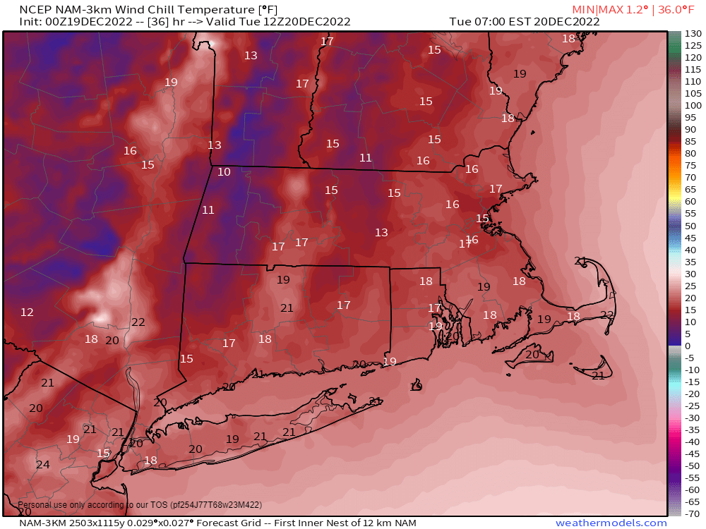
We start the week off with high pressure trying to build in while low pressure continues to meander around near Atlantic Canada. The result is dry weather through Wednesday as the high will be the dominant feature, but the gradient between the high and the offshore low will result in breezy conditions today and Tuesday. Temperatures will be fairly close to where they should be in the latter half of December.
Wind chills will be in the teens when many of you head out the door Tuesday morning. Image provided by Weathermodels.com
The end of the week is where things get rather complicated. Most of the models are trying to spin up a very strong storm and send it towards the Great Lakes. As a result, you’ve no doubt seen plenty of forecasts out there for a wind-swept mild rain on Friday. The people making these forecasts are taking the lazy way out, believing everything the models are saying, and not looking too deeply at the situation. That’s not how we do things here. Yes, the precipitation will be mostly likely be in the form of rain with this storm, and temperatures will probably be milder than normal. But a wind-swept mild rain? Far from a lock. In fact, we’re not sure that will materialize for a good chunk of the region. Allow us to explain:
First, the upper-level pieces of energy that will create the storm are still over water, in areas where there is little data, so the models are just guessing at this point. That will change in the next 24 hours or so as those upper-level disturbances move into Alaska and California respectively, so we’ll start to get a better idea of what will happen. Second, this storm may be in two parts, one late Thursday into early Friday and the second late Friday and Friday night, with a bit of a lull possible during the day on Friday. The first piece of energy, with the southern jet stream, likely stays weak and scoots along ahead of the main system. This may help to kick off a weak area of low pressure near the East Coast on Thursday, which could bring in some rain, but it may start a snow or a wintry mix across the interior before changing over to rain. As the northern stream energy moves into the Plains States, it will carve out a rather deep trough of low pressure at the upper-levels, which in turn will generate a rather potent storm system in the nation’s mid-section, which likely heads toward the Great Lakes. This is where our uncertainty starts to increase. Right now, the models keep those two streams separate. What happens if the southern stream storm is a little slower than the models forecast, and they do merge (or “phase”, as we usually call it)? Well, that could result in a stronger storm in the Midwest, possibly even a little farther west than the models show now. It also would lessen the likelihood of that rain and/or mix moving in here later Thursday. What about if that trough in the Plains States isn’t as sharp as the models predict? Well, then the storm ends up farther east, which has different implications here. When storms end up as far west the models currently show, it’s easy to look at the maps and say “it’ll be windy and warm east of the storm,” and assume that is the case all the way to the coast, but that’s the lazy way out.
The members of the GFS Ensemble all show a potent low near the Great Lakes on Saturday and a secondary low near or off the Mid-Atlantic coast. Image provided by WeatherBell.
In reality, when storms head up across the central and western Great Lakes, what usually happens is a weak wave of low pressure forms ahead of the main storm somewhere near the Mid-Atlantic states. What that does, is it pinches off the warm air at the surface. Yes, we’ll still have strong southerly winds pumping in lots of moisture and warmer air aloft, but at the surface, you end up with east or northeast winds, keeping the cooler air locked in under what we call an inversion. Normally, temperatures decrease with height as you head up into the atmosphere. When it’s warmer as you go higher, the temperature profile is “inverted”. This also prevents those strong winds aloft from mixing down to the surface. So, you may get windy and mild conditions near the South Coast, but places like the Merrimack Valley and southern New Hampshire could stay stuck in the upper 30s and lower 40s with little wind, but some rain, drizzle, and fog. We’ve seen this happen countless times, and wouldn’t be shocked if that’s what ends up happening around here on Friday. Eventually, as the storm moves into southeastern Canada, it will send a strong cold front in. Some rain, possibly heavy is likely ahead of that front, it the gusty winds associated with the front will eventually mix out that inversion, so temperatures could briefly spike well into the 50s or even lower 60s as the milder air moves in for a brief period ahead of, or even behind the front.
Friday’s high temperatures likely occur at night, then temperatures turn sharply colder on Saturday. Loop provided by Pivotal Weather.
For Christmas Eve and Christmas Day we’ll have high pressure trying to build in with clearing, breezy, and colder conditions.
Monday: Sunshine and some afternoon clouds, breezy. High 34-41.
Monday night: Clear skies. Low 22-29.
Tuesday: Plenty of sunshine. High 33-40.
Tuesday night: Clear to partly cloudy. Low 18-25.
Wednesday: A mix of sun and clouds. High 33-40.
Thursday: Mostly cloudy, rain developing late in the day, possibly starting as some snow or freezing rain across the interior. Rain may be heavy at night. High 39-46.
Friday: Cloudy, breezy along the coast, rain likely, possibly heavy at times, especially early and again late in the day. Rain may mix with or change to wet snow before ending at night. High 51-58 during the evening, but temperatures may stay in the upper 30s and 40s for much of the afternoon across the interior.
Christmas Eve: Becoming partly sunny and breezy with a few flurries possible, especially early. High 30-37 early, temperatures drop a little during the afternoon.
Christmas Day: Partly to mostly sunny, breezy, and chilly. High 25-32.
A rather complex storm system is heading this way, but the forecast itself isn’t too complex for most of us.
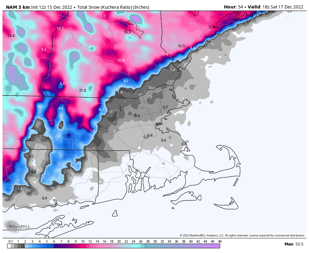
The storm system that’s been producing blizzard conditions in the Plains and severe weather in the South over the last few days will head towards the Great Lakes tonight as a secondary area of low pressure takes shape over the Mid-Atlantic states. That system will pass close to or over southeastern Massachusetts Friday night. Ahead of it, we’ll have rain moving into the region tonight. The rain may start as some wet snow across the hills of Worcester County and southwestern New Hampshire, possibly even in parts of south-central New Hampshire and the Merrimack Valley, but gusty easterly winds will quickly bring milder air in off the still relatively mild Atlantic, quickly changing any snow over to rain at the lower elevations. Friday will be a windy, rainy, and cool day across the region. Wind may gust as high as 40-50 mph near the shoreline, but with tides astronomically low, coastal flooding is not a concern. As the storm passes by Friday night, winds will shift from the east to the northeast and eventually north and northwest, bringing cooler air back in. The precipitation will be moving out, but the rain will likely change over to snow before it ends around midday across southern New Hampshire and possibly the Merrimack Valley. As for accumulations, we’re looking at an inch or less across the Merrimack Valley and the New Hampshire Seacoast, an inch or possibly two across southern New Hampshire (including Nashua and Manchester), and 3-5 inches up towards Concord. Across the hills of northern Worcester County and the Monadnocks of southwestern New Hampshire totals of 6-12 inches or more are likely.
The heaviest snow will be confined to the hills north and west of the region. Image provided by WeatherBell.
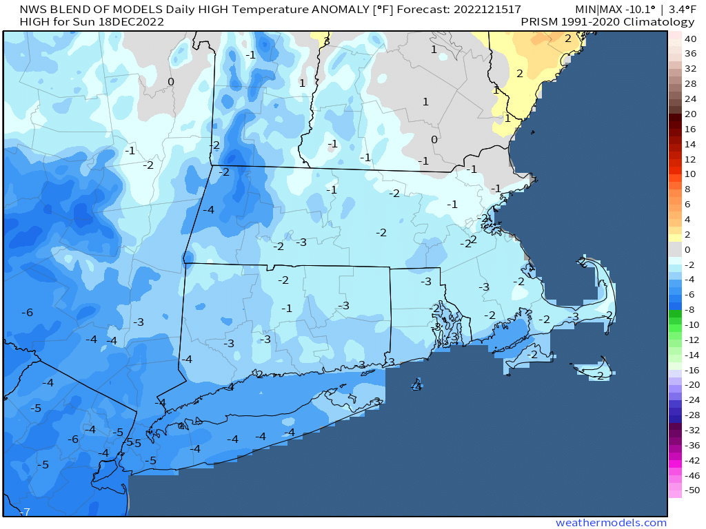
Once the storm moves out, temperatures will slowly drop during the day on Saturday, then skies start to clear out at night. An upper-level low pressure system moves across the region on Sunday with some additional clouds and possibly a few flurries. High pressure then builds in for Monday with sunshine and seasonably cool conditions.
Sunday’s temperatures will be a little below normal for mid-December, Image provided by Weathermodels.com
Thursday night: Rain developing, possibly starting as a brief period of wet snow across southern New Hampshire, becoming breezy. Low 33-40 in the evening, then temperatures slowly rise overnight.
Friday: Windy with periods of rain, possibly heavy at times. High 39-46.
Friday night: Rain may change back to snow across southern New Hampshire, breezy. Low 30-37.
Saturday: Cloudy and breezy with rain or snow showers ending by midday. Some sunny breaks may develop late. High 37-44 in the morning, temperatures drop during the afternoon.
Saturday night: Becoming clear to partly cloudy. Low 23-30.
Sunday: Intervals of clouds and sun, chance for a few flurries, breezy. High 33-40.
Colder weather has arrived, and more is on the way, but so is some rain.
The week starts off with low pressure pulling away from the region, with any lingering snow showers ending this morning, then skies start to clear out as high pressure builds in. Clear skies, lighter winds, and some fresh snowcover will result in radiational cooling tonight, with many places dropping into the teens. High pressure remains in control on Tuesday with sunshine and cool temperatures. An upper-level disturbance moves through on Wednesday, and it may be accompanied by some snow showers, especially along the coast. Even colder air settles in behind it for Wednesday night.
Wind chills will be in the teens when you leave the house Tuesday morning. Image provided by WeatherBell.
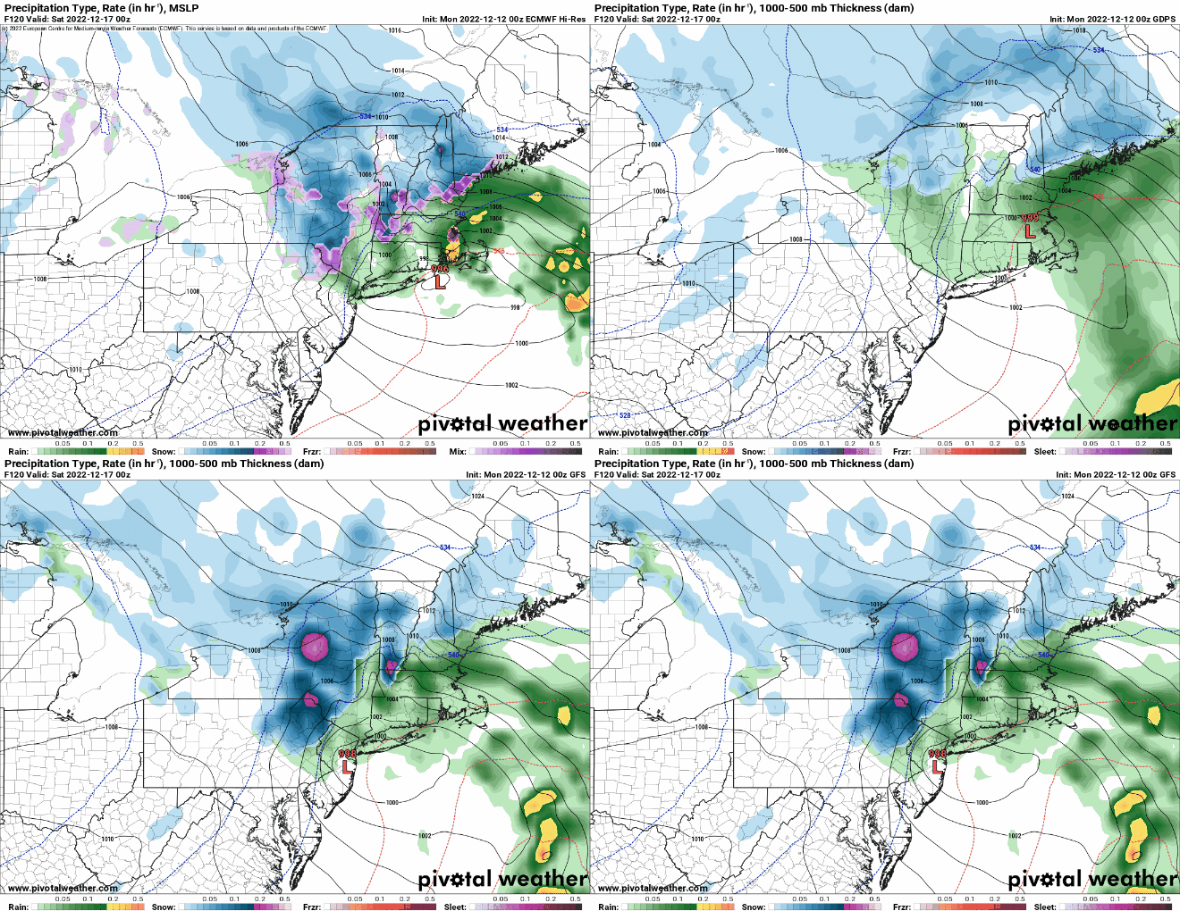
Clouds start to stream back in on Thursday as low pressure begins to head toward the region from the Southwest. For most of the region, this looks like a rainstorm for Thursday night and Friday, but a period of snow or wintry mix to start across parts of central Massachusetts and southwestern New Hampshire. However, this is still 4-5 days away, and a lot can change between now and then. Even small changes to the track that the low takes can have a big impact on the forecast. A track farther south and/or east could result in in wintry weather for a larger portion of the region and potentially for a longer period of time. We’ll be keeping a close eye on this as the week goes on. Behind the storm, cooler and drier weather returns next weekend.
Friday looks rather unsettled, but there are still plenty of details to work out. Images provided by Pivotal Weather.
Monday: Any lingering snow showers end early, then becoming partly to mostly sunny and breezy. High 33-40.
Monday night: Some clouds across the Outer Cape, otherwise clear and chilly. Low 16-23.
Cooler weather is on the way, and it looks like may even a little snow too.
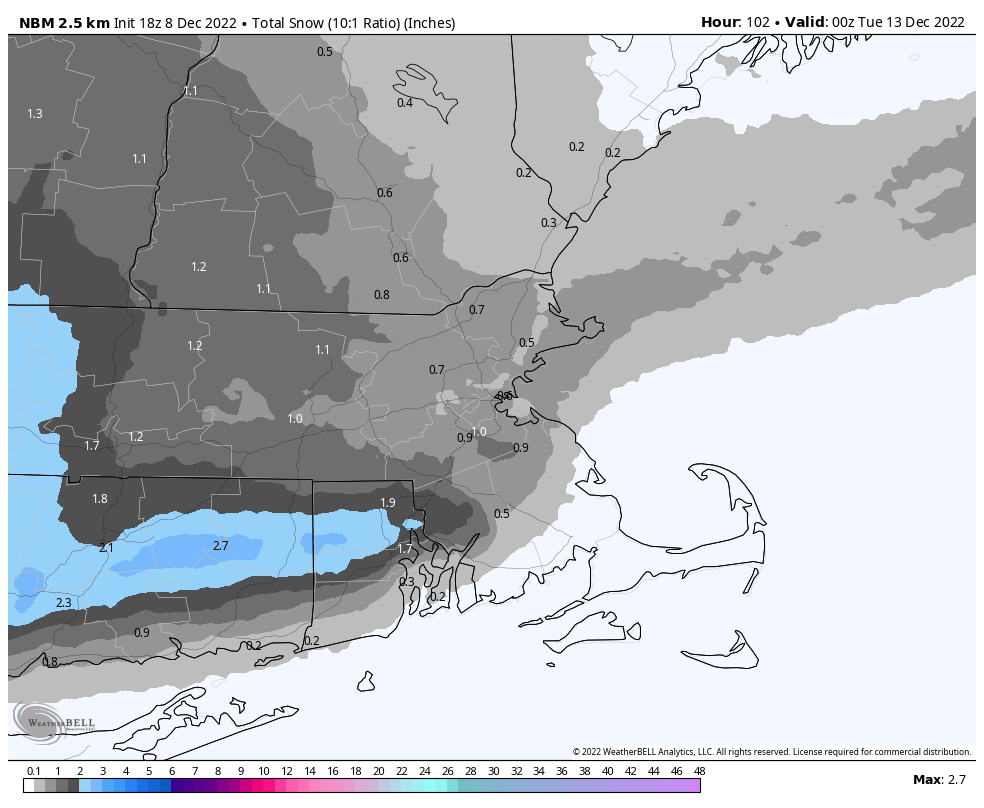
High pressure builds in with cool and dry conditions tonight and Friday. Some clouds may start to filter in for Friday night and Saturday as a large ocean storm starts backing in. With a persistent east to northeast flow around this storm, we could see some drizzle or a few showers on Saturday across parts of eastern Massachusetts, especially Cape Cod. The clouds hang around on Sunday as another low pressure system moves into the eastern Great Lakes before heading southeastward, passing south of New England Sunday night and early Monday. It will spread some precipitation in, and with temperatures near or below freezing at night, it may fall in the form of snow. Most of the precipitation will fall west of our area, but some snow showers or even a period of light snow seems likely. For many of us, it will probably be enough to coat the ground, with a few spots possibly seeing an inch or so, except across Cape Cod and southeastern Massachusetts, where it will be more rain than snow. This is not a big storm, and most of the snow will fall Sunday night and early Monday, so keep that in mind if you’ll be out and about. The system pulls away on Monday, and high pressure builds back in with sunshine returning.
A little light snow is expected Sunday night. Image provided by WeatherBell.
Thursday: Clear skies. Low 25-32.
Friday: Plenty of sunshine. High 38-45.
Friday night: Clear through the evening, clouds start to move in late at night. Low 22-29, a little milder across southeastern Massachusetts.
Saturday: Mostly cloudy, chance for some drizzle or a few showers, mainly across Cape Cod and southeastern Massachusetts. High 33-40.
Saturday night: Mostly cloudy, showers or drizzle taper off in the evening. Low 22-29, a little milder across southeastern Massachusetts.
Sunday: Plenty of clouds, snow showers possible late in the day, mixed with rain across Cape Cod. High 31-38.
Sunday night: Scattered snow showers, except rain or snow showers across Cape Cod. Low 23-30.
Monday: Any lingering rain or snow showers end early, becoming partly to mostly sunny in the afternoon. High 34-41.









 Storm HQ