We’ve got another fairly quiet week coming up with some rather mild weather on the way once again.
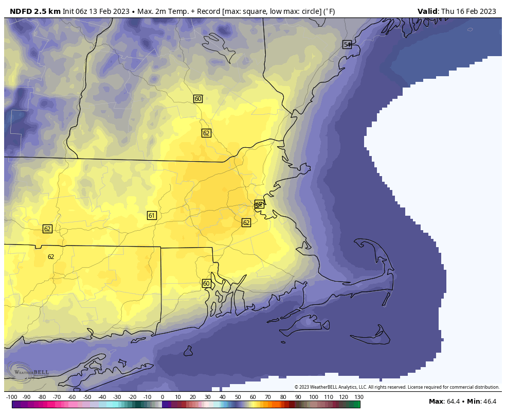
We start the week off with low pressure pulling away from the region. Any lingering showers across Cape Cod will end this morning, but skies will remain cloudy. An upper-level disturbance moves through tonight with more clouds, and possibly a few snow showers, mainly north of Route 2. High pressure then builds in for Tuesday with clearing and mild temperatures. The warming trend will continue for Wednesday and Thursday, with highs on Thursday possibly setting some records with temperatures topping 60 in some spots. Wednesday will remain dry, but some rain will develop later on Thursday as low pressure heads toward the St. Lawrence Valley. The rain will end on Friday as the system drags a strong cold front across the region. The timing of this front is a huge question mark right now, and that will have a significant impact on the temperature forecast. The later the front moves through, the more likely we have another warm day with more record highs possible. An earlier frontal passage results in a cooler day. Either way, high pressure builds in for the weekend with dry and much cooler conditions.
Monday: Mostly cloudy, any lingering showers near the South Coast and Cape Cod end in the morning. High 40-47.
Monday night: Partly to mostly cloudy, chance for a few snow showers or flurries, mainly north of Route 2. Low 28-35.
Tuesday: Becoming mostly sunny and breezy. High 42-49.
Tuesday night: Clear during the evening, then clouds increase once again. Low 26-33.
Wednesday: Intervals of clouds and sun, windy. High 49-56.
Thursday: Becoming mostly cloudy and breezy with showers likely late in the day and at night. High 58-65, cooler across the South Coast and Cape Cod.
Friday: Mostly cloudy with showers ending, some late-day clearing, windy. High 52-59, temperatures drop during the afternoon.
Saturday: Plenty of sunshine, breezy, and cooler. High 32-39.
Sunday: Partly sunny and breezy. High 44-51.
