After 2 Days of Severe Weather, The East Will Be Quiet This Weekend

Severe weather has been widespread across the eastern half of the nation for the past 2 days, but high pressure will bring much quieter conditions this weekend.

A cold front has been slowly dropping southward over the past 2 days, replacing warm and humid air with cooler and drier conditions. Ahead of the front, strong to severe thunderstorms have cut a large swath of damage.
yesterday_filtered
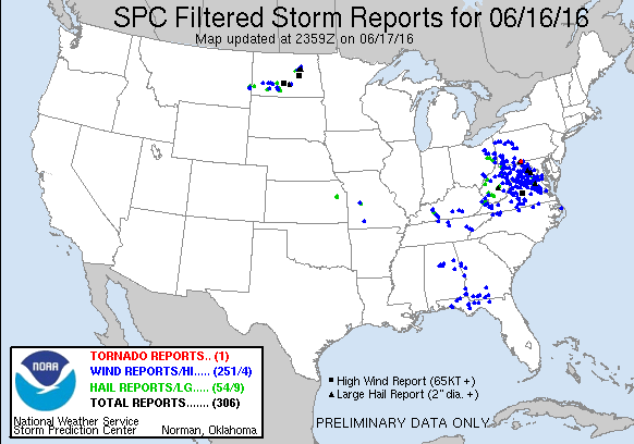
Reports of severe weather from Thursday June 16. Image provided by the Storm Prediction Center.

On Thursday, severe weather was widespread across the Mid-Atlantic states from mid-afternoon through the late evening hours. There were over 250 reports of damage from wind gusts as high as 77 mph, with a majority of the reports concentrated in West Virginia, Virginia, and Maryland, including the Washington, DC metropolitan area, where thunderstorms dropped 2.58″ of rain in just a couple of hours at Dulles Airport. In addition to the wind damage and heavy rain, hail as large as baseballs was observed with some of the strong storms. One tornado was also confirmed in Barnes Gap, Pennsylvania.

While most of activity quieted down in the evening, thunderstorms flared up across North Dakota and Minnesota. A cluster of storms moved across the state early in the morning, producing baseball-sized hail near Bismarck. Wind gusts as high as 80 mph were also reported across the region.

CODNEXLAB-regional-southeast-rad-ani96-201606180055-100-100-raw.gif

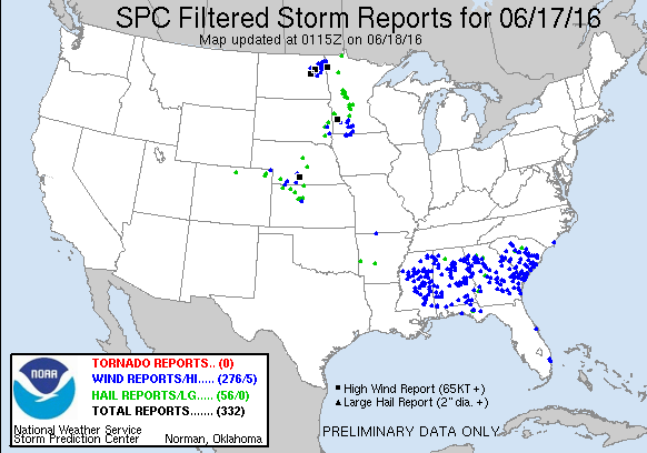
By Friday afternoon, activity started to flare up again across the Southeast ahead of the cold front. A line of strong to severe thunderstorms quickly developed from Mississippi to South Carolina and began to march southward. Widespread wind damage was reported across the region as wind gusted as high as 70 mph in some of the stronger storms. These storms also produced torrential rainfall, with 2.32″ falling in one hour in Columbus, Mississippi.
today_filtered
Reports of severe weather from Friday June 17. Image provided by the Storm Prediction Center.

Across the Plains states, under sunny skies temperatures soared well into the 90s and lower 100s on Friday.  Another cold front moving into the Western Plains provided the necessary lift to trigger thunderstorms across portions of Kansas and Nebraska. Once the activity got going, it quickly exploded into a large cluster of strong to severe thunderstorms. In McCook, Nebraska, the temperature reached 99 degrees during the afternoon with a dewpoint in the upper 60s to lower 70s. As a severe thunderstorm moved into the region, it produced a wind gust to 72 mph and dropped over 2 inches of rain on the area. It also sent temperatures tumbling into the middle 60s.

CODNEXLAB-1km-W_Kansas-rad-ani96-201606180100-100-100-raw.gif
Radar loop for Kansas and Nebraska from Friday afternoon June 17. Loop provided by the College of Dupage.

Much quieter conditions are expected over the weekend as a large area of high pressure builds into the eastern half of the nation. Sunshine and seasonably warm temperatures are expected for most of the region, with thunderstorm activity mostly confined to the Gulf Coast, near the dying frontal boundary that produced severe weather over the past few days, and the Northern Plains, where a strong cold front will slowly move through this weekend.

Here in New England, we’re looking at plenty of sunshine right through Monday. Temperatures will be mainly in the middle 70s to lower 80s on Saturday, and well into the 80s for Sunday and Monday, with a few places possibly topping 90 degrees. The cold front crossing the Northern Plains this weekend will move into New England at some point on Tuesday. With a warm and humid airmass in place, the front will likely trigger showers and thunderstorms as it moves through. However, the timing of the front will be the key to determining whether we just have a few showers and thunderstorms, or more widespread strong to severe storms. The details on that will be come clearer as we get closer to Tuesday.

It’s Going to get Hot, Hot, Hot! (Not Around Here Though)

A ridge of high pressure over the Plains states will slowly shift westward over the next few days, with intense heat across the Plains heading for the Desert Southwest.

High temperatures soared well into the 90s across the Southern Plains on Wednesday, but when the humidity was factored in, the heat index exceeded 100-110 degrees in parts of the nation’s midsection.  Only a few showers and thunderstorms provided scattered relief to the region. On Thursday, with similar conditions expected across much of the Southern Plains and parts of the Mississippi Valley, heat advisories have been posted for much of the region. High temperatures will be well into the 90s once again with some triple digit readings expected. When the humidity is factored in, heat index values will be in the 100-115 degree range across the region.

gfs_hindex_tx_6
Forecast for heat index values for Thursday afternoon. Image provided by WeatherBell

While the nation’s midsection has been enduring the heat, a trough of low pressure has been keeping the West cool for the past few days. Temperatures have been as much as 10 to 20 degrees below normal, especially across the Pacific Northwest. Across the higher elevations of the Cascades, several inches of snow has been reported.

500hv.conus
Forecast for 500mb heights for Sunday June 19. Image provided by Pivotal Weather.

While the Northwest will remain cool into the weekend, much warmer weather will move into the Southwest as a ridge of high pressure builds westward. By Saturday, temperatures will be 10-20 degrees above normal in the Desert Southwest. For a place that is “normally” hot, anomalies that big can break records. In Phoenix, high temperatures could approach 120 degrees on Sunday. The record high for that day is 115, set in 1968.

gfs_t2max_lower48_14
High temperature forecast from the GFS model for Saturday June 18. Image provided by WeatherBell.
gfs_t2max_lower48_18
High temperature forecast from the GFS model for Sunday June 19. Image provided by WeatherBell.

Excessive heat watches have been posted for much of the Southwest from Saturday through Tuesday. The hottest days look to be Sunday and Monday, when high temperatures will likely exceed 110 degrees in Las Vegas, and could approach 120 degrees in Phoenix and Yuma. In Death Valley, California, high temperatures on Sunday and Monday could approach 125 degrees.
Even at night, there will be little relief, as low temperatures may only drop into the 80s to lower 90s across the area. In Death Valley, temperatures may only drop below 100 degrees for a couple of hours.

While temperatures may drop a few degrees later in the week, the ridge of high pressure is expected to remain in place across the Southwest right through the end of the month, keep temperatures above to well above normal.

Here in New England, high pressure will keep us dry and seasonably warm right into the start of next week. Temperatures could get well into the 80s Monday and Tuesday, but no sustained heat is expected for at least the next 10 days.

Weekly Outlook – June 13-19, 2016

Sunshine. Fair-weather cumulus clouds. Gusty winds. Below normal temperatures. Upper-level low pressure. Low humidity. Ridge of high pressure. Above normal temperatures. All of these things are part of the forecast for at least one day this week. See anything missing from that list? Go on, give it another look. We’ll wait. Give up? If you said “rain”, then you’re correct! That’s right, we appear to have a rain-free week coming up across the area.That’s great if you’re on vacation, otherwise, not so much. You see, we’re actually in a drought around here, and it’s slowly been getting worse, because we haven’t received a lot of rain over the past few months. So, we actually need the rain.

20160607_northeast_trd
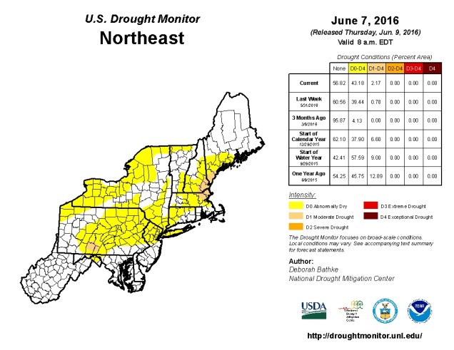
Latest update on drought conditions across the Northeast. Some moderate drought is starting to appear across northeastern Massachusetts, southeastern New Hampshire, and extreme southern Maine. Graphic provided by the National Drought Mitigation Center.

The week will start off on the cool side with an upper-level low pressure area slowly moving across southeastern Canada. This will also provide some gusty winds for Monday and possibly Tuesday, but they won’t be as strong as we saw on Sunday. As the low pulls away and high pressure builds in, we’ll see sunshine for the latter half of the week, with temperatures gradually rising. It still doesn’t look like there’s any sustained heat in our future, but a few warm days are possible at times, especially as we head into next week.

Monday: Sunshine and some afternoon clouds, breezy. High 67-74.

Monday night: Mostly clear.Low 49-56.

Tuesday: Partly to mostly sunny. High 71-78.

Tuesday night: Clear skies. Low 52-59.

Wednesday:A mix of sun and clouds. High 74-81.

Thursday: Partly sunny.High 76-83.

Friday:A mix of sun and clouds. Just a slight chance for a pop-up shower in the afternoon. High 69-76.

Saturday: Plenty of sunshine.High 74-81.

Sunday: Mostly sunny.High 79-86.

We must note that there is the possibility that next weekend is not as sunny or mild as our forecast suggests. The ECMWF model paints a starkly different picture.

ecm_mslp_east_8
ECMWF forecast for Sunday morning June 19. Image provided by WeatherBell.

As you can see above, the ECMWF has a Nor’easter develop and slowly move up the coast, giving us windy, cool, and damp conditions from Friday into early next week. The GFS model shows this feature as well, but it has it significantly farther south, and much weaken when it does start to move northward during the first half of next week. For now, we’re leaning towards the GFS solution, but we figured we’d let you know that there is still a chance that next weekend will suck. If that chance grows at all during the week, we’ll let you know.

Severe Weather on Saturday? Maybe.

For the second weekend in a row, there is a threat for severe weather across parts of the Northeast. Unlike last weekend, when the threat was centered on areas from the Delmarva Peninsula southward to the Carolinas, the threat on Saturday is focused on the Northeast.

CODNEXLAB-2km-MI-rad-ani24-201606110125-100-100-raw
Strong to severe thunderstorms moved across the Midwest Friday evening. Loop provided by College of DuPage NexLab.

Low pressure is moving across Lake Superior this evening, with a warm front extending east and southeast from the system across the eastern Great Lakes and into Virginia. A cold front trails the system into the Dakotas and Wyoming. South of these two fronts a very warm and humid airmass is in place, with temperatures well into the 80s and 90s on Friday. Dewpoints were in the 60s to lower 70s across much of the region as well. As the cold front moved into the Upper Midwest, it helped ignite a line of strong to severe thunderstorms. These storms produce golfball-sized hail and wind gusts as high as 76 mph as they cross Minnesota and Wisconsin Friday afternoon and evening.

Usually, strong to severe thunderstorms diminish during the evening hours as they lose the heating of the sun. However, with the warm and humid air in place across the Midwest, these storms will likely continue to march eastward overnight ahead of the cold front.

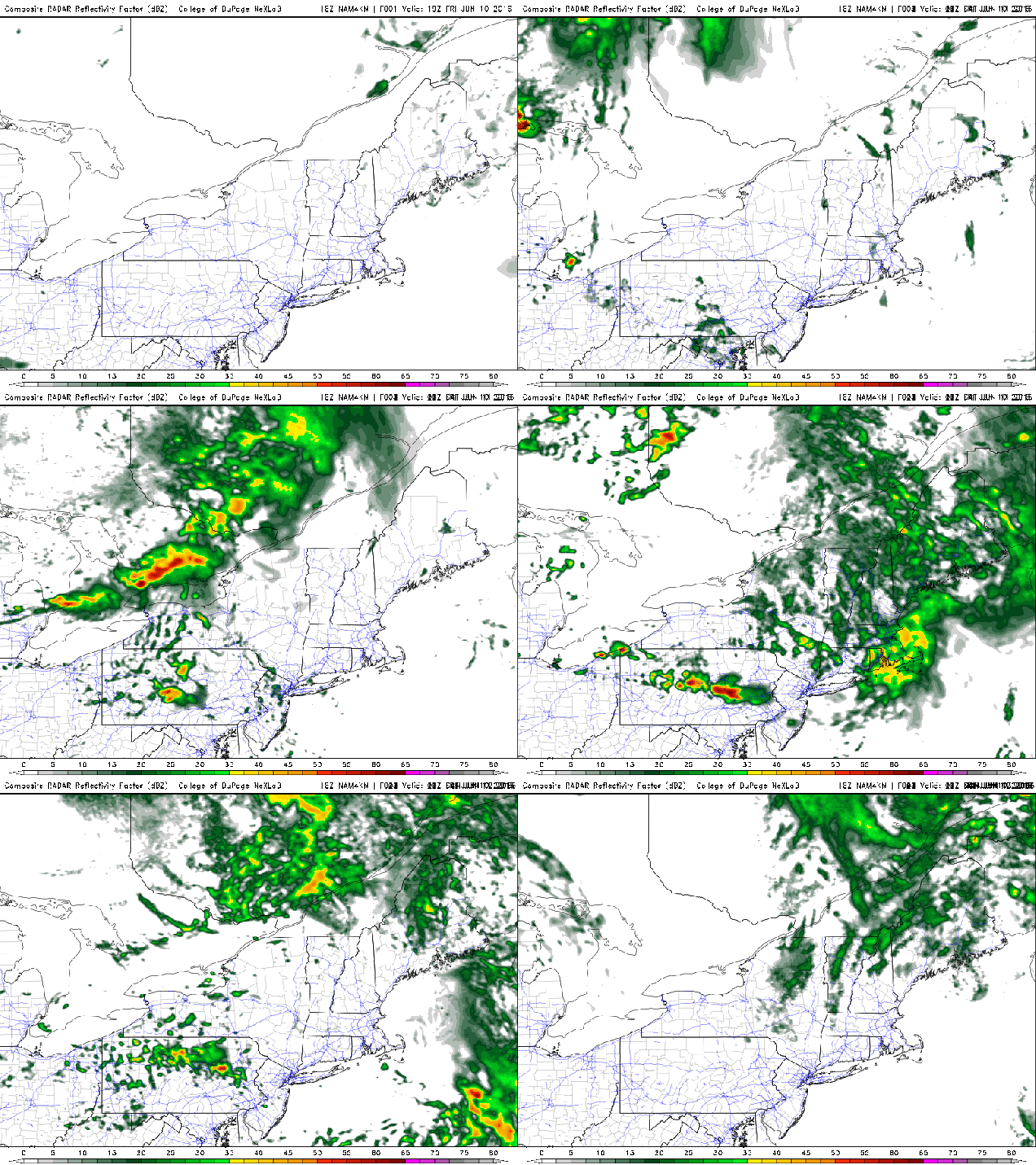
18Z-20160610_NAM4KMNE_prec_radar.gif
Radar loop predicted by the NAM Model from Friday night into Sunday night. Loop provided by College of DuPage NexLab

Forecast models indicate that this line of thunderstorms will move across portions of New York and Pennsylvania Saturday morning and afternoon before moving into portions of New England. How far north and east the warm front moves will help determine where the best chance for severe weather will be located.

hires_t2max_neng_28
High temperature forecast for Saturday afternoon based on the NAM model. Image provided by WeatherBell.
hires_dew2m_neng_28
Dewpoint forecast for Saturday afternoon based on the NAM model. Image provided by WeatherBell.

Right now, it looks like the warm front will only make it into New York and southwestern New England before the cluster of showers and thunderstorms arrives. Some of the stronger storms could produce downpours, strong winds, and hail across portions of New York, Pennsylvania, and New Jersey.

Across New England, the threat for the afternoon seems less, with more typical showers and thunderstorms expected. However, this does not mean that the threat is zero. If the warm front were to make progress farther northward, the threat would increase. The bigger threat in this region could come at night. The warm front should eventually push through during the evening, allowing the warm and humid air to move into Southern New England. As the cold front continues it eastward march, another round of showers and thunderstorms will likely develop along and ahead of it. As these storms move across New England overnight, some of those storms could produce heavy downpours and strong winds.

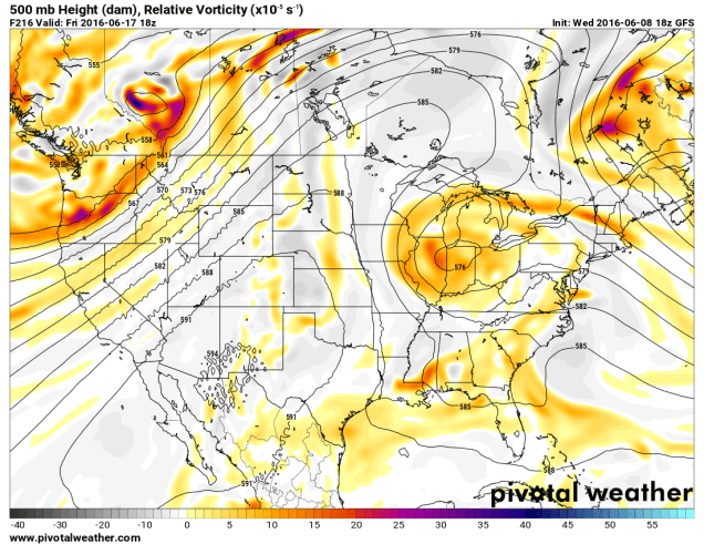
500wh.conus
Forecast for 500mb heights and winds based on the NAM model. Image provided by Pivotal Weather.

After the cold front moves through Saturday night, skies should become partly to mostly sunny across the Northeast on Sunday with near-to-below normal temperatures expected. An upper-level low will slowly move across the Gulf of Maine early next week, keep temperatures near or below seasonal normals while heat and humidity dominate the remainder of the eastern two-thirds of the nation.

Here Comes the Heat (Except for You New England)

A large ridge of high pressure will shift from the West Coast into the Nation’s midsection over the next few days, bringing with it some of the hottest weather so far this year to the Plains states.

ncep_cfsv2_120_t2anom_usa
Temperature anomalies for the past 30 days across the nation. Image provided by WeatherBell.

A persistent ridge of high pressure has been anchored across the West for the past few weeks, keeping temperatures well above normal for much of May and early June. Numerous records were set across the region, even in normally hot locations like the Desert Southwest, where temperatures exceeded 110 degrees several times. In Death Valley, California, which is frequently the nation’s hotspot, the first 8 days of June have averaged 10.6 degrees above normal, with high temperatures exceeding 115 degrees each day.

While the West has been baking, temperatures across the Plains states have been 1 to 3 degrees below normal for the past month. That is about to change as the ridge slides eastward. By the end of the week and the weekend, the ridge will be centered across the Plains and doesn’t look to move that much right through next week.

500hv.conus (1)
Map showing heights at the 500mb level across the United states on Sunday June 12. Image provided by Pivotal Weather.

500hv.conus (2)

With the ridge of high pressure in place, temperatures will soar well into the 90s across the Plains states and adjacent portions of the Mississippi Valley for much of the remainder of the week, with some triple-digit heat possible across parts of the Dakotas, especially Friday and Saturday.

Some relief will settle into the Northern Plains in the form of a cold front early next week, but the heat will continue from the Southern Plains and Texas eastward into the Southeast. Across these areas, humidity levels will be higher, with dewpoints rising into the 60s and 70s. The result will be heat index values well over 100 degrees across parts of these areas.

gfs_t2max_mw_14
High temperature forecast based off of the GFS model for Saturday June 11. Image provided by WeatherBell

The ridge will also act to suppress thunderstorm activity across the Plains states for much of the remainder of the week. Cluster of thunderstorms may develop across the Northern Rockies and ride over the Ridge and into the Great Lakes and eventually the Northeast later in the week. One of these clusters could produce some severe weather across the Eastern Great Lakes and Mid-Atlantic states on Saturday.

While the heat settles in across the Plains temperatures will remain cool across the Northeast. An upper-level low pressure system will only slowly move eastward across southern Canada over the next few days, moving into the Gulf of Maine by early next week. While temperatures surge into the 90s and lower 100s across the Dakotas on Friday, temperatures will only be in the 60s to lower 70s across the Northeast, with parts of Northern New England staying in the 50s. A few showers may pop up during the afternoon, and across some of the higher peaks of the region, some wet snowflakes could mix in with the rain.

There are signs that things could change in New England, but not until the end of next week. Some of the forecast models are indicating the possibility that the upper-level low finally moves out, allowing the heat to finally spread eastward. The latter half of June could feature much warmer conditions if this does come to pass.

gefs_t2ma_5d_noram_63
Temperature anomalies forecast by the GFS Ensemble for the period June 19 through June 24. Image provided by WeatherBell.

Colin (or what’s left of it) is Hitting Florida, Severe Weather on Tuesday in New England?

Often, you’ll hear meteorologists say not to focus on the center of a tropical system, because its effects can be felt far from the center. Tropical Storm Colin is a terrific example of this.

vis_lalo-animated
Satellite loop of Tropical Storm Colin from Monday afternoon. Loop provided by NOAA.

The “center” of Tropical Storm Colin is about to cross the coast of the Big Bend of Florida this evening. As of 11pm, the center was about 70 miles east of Apalachicola, Florida, moving northeast at 22 mph. Maximum sustained winds are near 50 mph. While the center is about to cross the coast, most of the thunderstorm activity is located east and northeast of the center. Heavy rain has been falling for most of the day across much of Florida as well as parts of Georgia and the Carolinas, but there have only been a few reports of tropical-storm force winds.

Tropical Storm Warnings remain in effect for the Gulf Coast of Florida from Indian Pass to Englewood, and along the Atlantic coast from Sebastian Inlet, Florida northward to Oregon Inlet, North Carolina. The current forecast from the National Hurricane Center calls for Colin to cross northern Florida and southern Georgia overnight, then move back into the Atlantic on Tuesday. Colin will likely have lost tropical characteristics by then (some would that it is already doing that), but it may still strengthen a bit as it passes offshore of the Carolinas. The main impact will be heavy rain and flooding near the coast. Flood watches are in effect for much of the region.
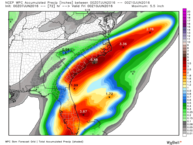
wpc_total_precip_se_12
Expected rainfall between Monday evening and Thursday evening. Image provided by WeatherBell.

Once Colin or its remains pull away from the Carolinas it will head out into the open Atlantic. Aside from impacting the fish and marine traffic, the system could pass close enough to Newfoundland to bring some gusty winds and rainfall to the island later this week.

Meanwhile, the first tropical depression of the season has formed in the Eastern Pacific Ocean. As of 11pm EDT, Tropical Depression One-E was centered about 125 miles south-southwest of Salina Cruz, Mexico, heading towards the northeast at 7 mph. A Tropical Storm Watch has been posted for the coast of Mexico from Puerto Escondido to Boca De Pijijiapan.

01E_intensity_latest
Computer model forecasts for the intensity of Tropical Depression One-E. Image provided by Tropical Tidbits.
01E_tracks_latest
Computer model forecasts for the track of Tropical Depression One-E. Image provided by Tropical Tidbits.

The system is expected to remain weak while drifting towards the northeast over the next day or two. The system could dissipate before making landfall. One thing it will do is produce very heavy rainfall across southern Mexico and adjacent Central America. Rainfall totals of 5-10 inches are expected with heavier amounts possible. This will lead to flash flooding and mudslides across the region.

qpf_acc_mm.mx
GFS model forecast for rainfall across Mexico for the next 4 days. Image provided by Pivotal Weather.

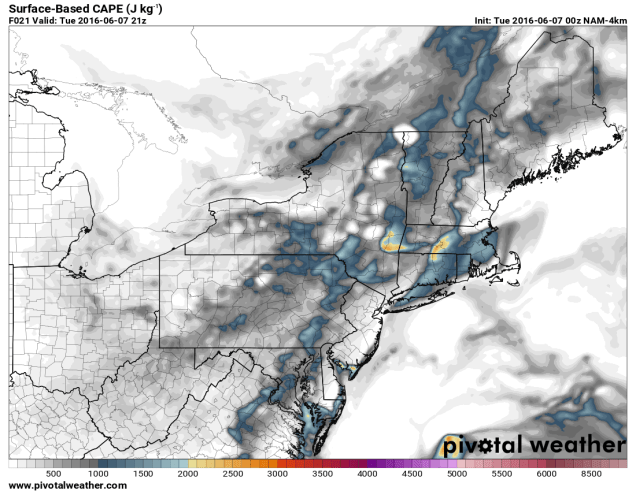
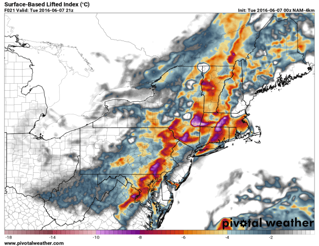
Closer to home, we have a possibility of severe weather around here on Tuesday. A cold front will cross the region during the afternoon, likely producing some showers and thunderstorms. Before that, we’ll have some cloud cover and showers around in the morning. If we can get enough sunshine to develop during the afternoon, it could help produce instability for another round of showers and thunderstorms, some of which could be strong to severe. Right now, it looks like the best chance for and strong storms will be from western and central Massachusetts into southern Vermont and southern New Hampshire, but again, this is dependent on how much sunshine we get. Any storms that do form may contain heavy downpours, gusty winds, and hail.

sbcape.us_ne (1)
NAM model forecast of CAPE values for 4pm Tuesday. Notice that the higher values are across central and western Massachusetts. Image provided by Pivotal Weather.
sbli.us_ne (1)
NAM model forecast of Lifted Index values for 4pm Tuesday. Notice that the higher values are across central and western Massachusetts. Image provided by Pivotal Weather.

After the front moves through, cooler weather will settle in for Wednesday, but a secondary cold front may produce another round of showers and thunderstorms Wednesday afternoon. With much cooler air aloft, there’s a better chance that any storms that form on Wednesday may contain small hail, but widespread severe weather isn’t expected.

Weekly Outlook June 6-12

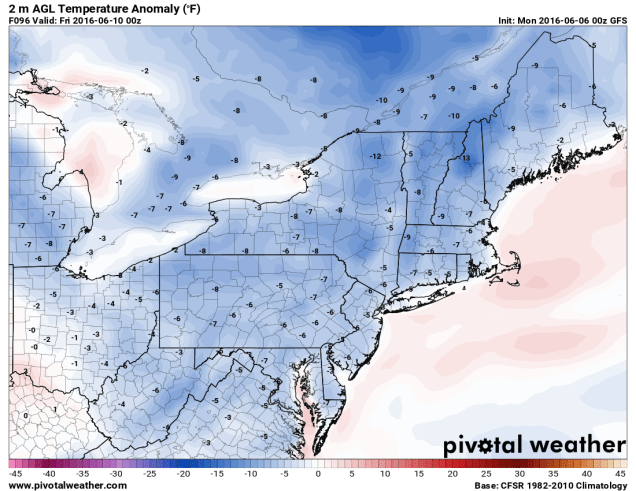
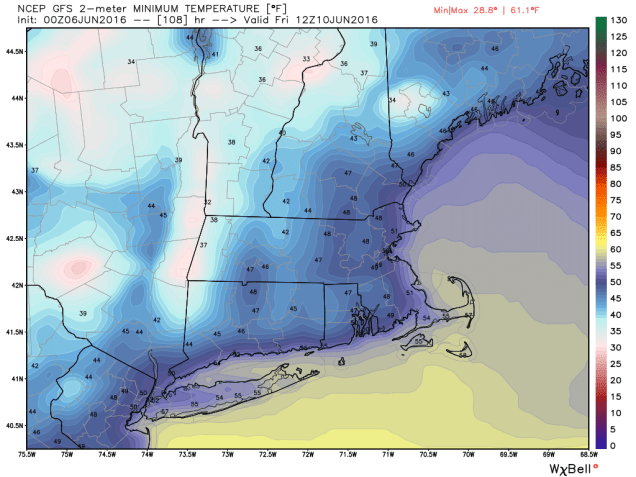
The upcoming week is going to feel like Summer to start and Spring to end. The first half of the week will be unsettled, with an upper-level low pressure area in southern Canada controlling our weather. Although it will be warm, we’ll have a daily chance of showers and thunderstorms through mid-week, with the best chance coming on Tuesday as a cold front crosses the region. By Thursday we’ll start to dry out as high pressure builds in behind the cold front, but with it will come unseasonably cool conditions. Things may turn unsettled again next weekend as another storm system may move through the region.

sfct_anom.us_ne
Temperatures on Thursday could be 5-10 degrees below normal across the region based on the GFS model. Image provided by Pivotal Weather.

Monday: Partly to mostly sunny, just a slight chance for an afternoon shower.High 78-85.

Monday night: Clear to partly cloudy. Low 56-63.

Tuesday: A mix of sun and clouds with afternoon showers and thunderstorms developing. High 76-83.

Tuesday night: Becoming clear to partly cloudy. Low 52-59.

Wednesday: Partly sunny, chance for afternoon showers and thunderstorms.High 66-73.

Thursday: Intervals of sunshine and clouds, breezy. High 60-67.

Friday: Partly to mostly sunny.High 63-70.

Saturday: Becoming partly to mostly cloudy, chance for a few showers late. High 67-74.

Sunday:Mostly cloudy with a chance for more showers. High 65-72.

gfs_t2min_boston_19
GFS model forecast for low temperatures Friday morning. Turn off the AC and open the windows because it might drop into the 40s across much of the area. Image provided by WeatherBell.

Tropical Storm Colin should pass well south and east of the region later this week, with minimal impacts on our region. It might increase the surf a bit along south-facing coastlines, so grab your wetsuit and board if that’s your thing. Otherwise, you should probably stay out of the water because A) it’s still pretty chilly and 2) it’s not that safe.

Attention Florida – Colin is Calling

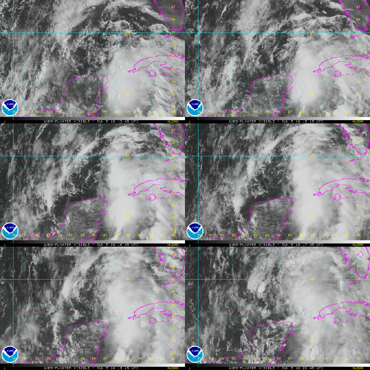
Just when you thought it was safe to call the tropics quiet with Bonnie disappearing, a new tropical depression has formed.

Earlier today, Tropical Depression Three was born in the southern Gulf of Mexico. As of 5:30pm EDT, the system was upgraded to Tropical Storm Colin with top winds near 40 mph. Colin was centered about 465 miles southwest of Tampa, Florida, moving towards the north at 12 mph. The current forecast is for Colin to turn more towards the northeast over the next day or so and strengthen.

vis_lalo-animated
Colin already looks more impressive than Bonnie did. Loop provided by NOAA.

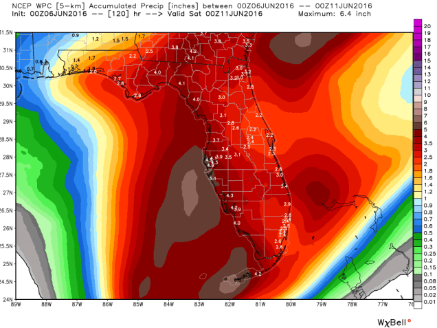
Based on the current forecast track, a tropical storm warning has been issued for the west coast of Florida from Indian Pass to Englewood. A tropical storm watch has also been issued for the Atlantic coast from Altamaha Sound, Georgia to the Flagler/Volusia County border in Florida. While the system will likely bring gusty winds to the region along some minor storm surge flooding near where it makes landfall, the biggest impact by far will be heavy rainfall and the flooding it likely produces.Most of the state can expect between 2 and 5 inches of rain, with isolated totals of up to 10 inches possible. Flood watches are already in effect for portions of the state, and more will likely be issued.

wpc_total_precip_florida_20
Expected rainfall across Florida over the next five days. Image provided by WeatherBell

Once the system crosses Florida it will likely move into the Atlantic and continue on a northeasterly track out into the open Atlantic. The system may be close enough to the coast to bring additional heavy rain to parts of the Carolinas that were deluged by Bonnie a week ago. This could lead to additional flooding in this area.

03L_tracks_latest
Computer model forecasts for the track of Tropical Storm Colin. Image provided by Tropical Tidbits.
03L_intensity_latest
Computer model forecasts for the strength of Tropical Storm Colin. Image provided by Tropical Tidbits.

Meanwhile, in the Eastern Pacific Ocean, there are now two areas being monitored this evening. The first one is the same one we’ve been watching all week. An area of low pressure is centered about 1100 miles southwest of Cabo San Lucas, Mexico, heading westward out into the open waters of the Pacific. Despite the models insisting all week that the system would develop (and some continue to insist on this happening), the system has not gotten its act together, and conditions won’t remain favorable for more than another day or two. So, we can probably write this system off.

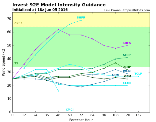
The more immediate concern is a disorganized cluster of showers and thunderstorms a few hundred miles south of Acapulco, Mexico. This system will slowly drift towards the northeast over the next few days, with some strengthening possible. It could become the first tropical depression of the season in the Eastern Pacific by midweek.

92E_tracks_latest
Computer model forecasts for the track of a tropical disturbance south of Mexico. Image provided by Tropical Tidbits.
92E_intensity_latest
Computer model forecasts for the intensity of a tropical disturbance south of Mexico. Image provided by Tropical Tidbits.

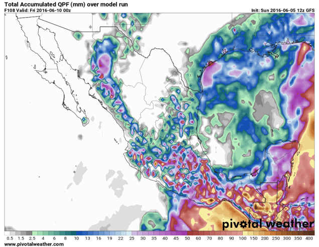
Whether the system develops into a tropical depression or not, it will bring heavy rainfall to portions of southern Mexico and Guatemala over the next several days. Rainfall totals of 5-10 inches are possible in this area, with some heavier amounts likely. This will also certainly lead to flash flooding across parts of the region.

qpf_acc_mm.mx
Rainfall forecast from the GFS model for the next four days for Mexico and adjacent Central America. Image provided by Pivotal Weather.

A Classic “Good News/Bad News” Weekend is Coming Up

Sunday isn’t looking that great around here, but things could be worse. Severe weather is likely across the Mid-Atlantic states on Sunday. Meanwhile, Tropical Storm Bonnie will head out into the open Atlantic this weekend, but another area is being watched for development near the Yucatan Peninsula.

We’re starting the weekend off with a fantastic Saturday here in New England, but big changes are coming. High pressure builds in today, so after some morning fog burns off we’ll have a mix of sunshine and clouds this afternoon. High temperatures will get into the upper 60s and 70s near the coastline, but away from the water, highs will be in the lower to middle 80s, with a few spots possibly reaching the upper 80s. Make sure you get outside and enjoy it because clouds will stream in late in the day ahead of a cold front moving across the Midwest.

Ahead of that front, with a warm, humid airmass in place, showers and thunderstorms will develop, some of which will become strong to severe. Widespread severe weather isn’t expected on Saturday, but there is a risk for some strong to severe storms from the Great Lakes into the Ohio Valley.  Sunday will be a different story. The ingredients will be in place for a severe weather outbreak from the Mid-Atlantic states into the Carolinas.

sbli.us_ma
GFS forecast of Lifted Index values for Sunday afternoon. Image provided by Pivotal Weather
sbcape.us_ma
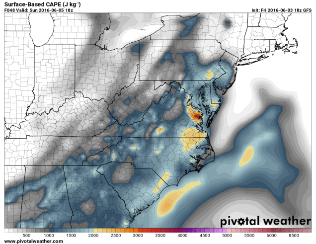
GFS forecast of CAPE values for Sunday afternoon. Image provided by Pivotal Weather

As temperatures rise into the 80s to lower 90s, the airmass will become increasingly unstable. CAPE, which is short for Convective Available Potential Energy, is a measure of instability through the atmosphere. CAPE values of 1000-3000 J/kg are expected from the Delmarva Peninsula into the Carolinas Sunday afternoon. These values are indicative of moderate instability in the atmosphere. The “Lifted Index” is the difference in temperature between the atmosphere at 500mb (about 18,000 feet up) and a parcel of air from the surface that is lifted to 500mb. A negative value is indicative of unstable conditions. On Sunday, forecast models are showing values between -4 and -9 across the Mid-Atlantic states.

While Sunday may start off cloudy with showers across parts of the region, breaks of sunshine should develop by early afternoon, with showers and thunderstorms developing along the eastern slopes of the Appalachians. Thunderstorm activity will likely organize into a line that will march eastward, reaching the Washington/Baltimore area by late afternoon, and the Richmond/Norfolk area towards evening. The main threats with any storms that do develop are strong winds, hail, and heavy downpours, with a few tornadoes also possible.

Up here in New England, we won’t have to worry too much about severe weather. That doesn’t mean we’ll have a great day. Rain will likely develop Sunday morning and continue for much of the day, ending late Sunday night or early Monday morning. We’re looking at an inch to an inch and a half of rain across the region, which we really need, as it’s been dry for the past few months. If you’ve got outdoor plans for Sunday, we’d start looking for alternate ideas. While the day may not be a complete washout, it’ll be cloudy, relatively cool (60s to lower 70s), and raining off and on for much of the day.
20160531_northeast_trd
Most recent update on drought conditions across the Northeast. Image provided by NOAA.
Meanwhile, Tropical Storm Bonnie has redeveloped east of North Carolina this evening. As of 5pm Friday, Bonnie was centered about 285 miles east of Cape Hatteras, NC, moving towards the east at 13 mph. Maximum sustained winds are near 40 mph. Bonnie is expected to head out into the open waters of the Atlantic over the weekend while steadily weakening.

vis_lalo-animated
Satellite loop of Tropical Storm Bonnie from Friday afternoon. Loop provided by NOAA.

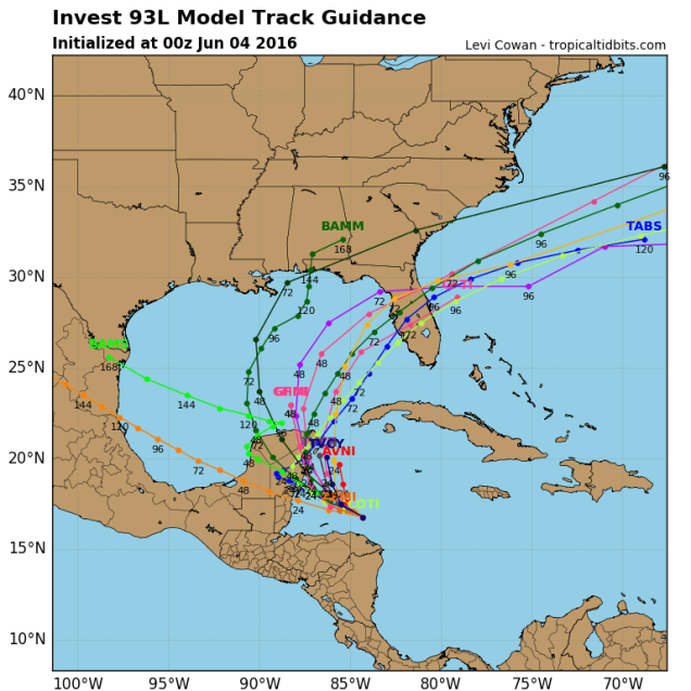
While June is usually quiet in the tropics, another area of disturbed weather in the western Caribbean is being monitored for development this weekend. A cluster of showers and thunderstorms will head towards the Yucatan Peninsula this weekend and then turn more towards the north and head into the Gulf of Mexico. For several days now, forecast models have been indicating that this system could become a tropical depression or tropical storm over the Gulf early next week.

93L_intensity_latest
Computer model forecasts for the strength of a potential tropical system in the Gulf of Mexico. Image provided by Tropical Tidbits
93L_tracks_latest
Computer model forecasts for the track of a potential tropical system in the Gulf of Mexico. Image provided by Tropical Tidbits

Most forecasts are for the storm to turn more toward the northeast early next week and cross the Florida Peninsula as a tropical depression or weak tropical storm. While winds aren’t expected to be strong, the main impact will be heavy rainfall. The storm could drop as much as 4-8 inches of rain on the Sunshine State next week, especially the southern half of the state. Heavy rain fell on portions of the region during May, so additional heavy rain could lead to flooding in parts of the area.

After all that, we didn’t even talk about the potential tropical system in the Eastern Pacific, the record heat in the West, the flooding in Paris and parts of western Europe, or the powerful storm impacting southeastern Australia. Yup, things are pretty busy in the weather office.

Bonnie’s Back! Will Colin Appear Soon?

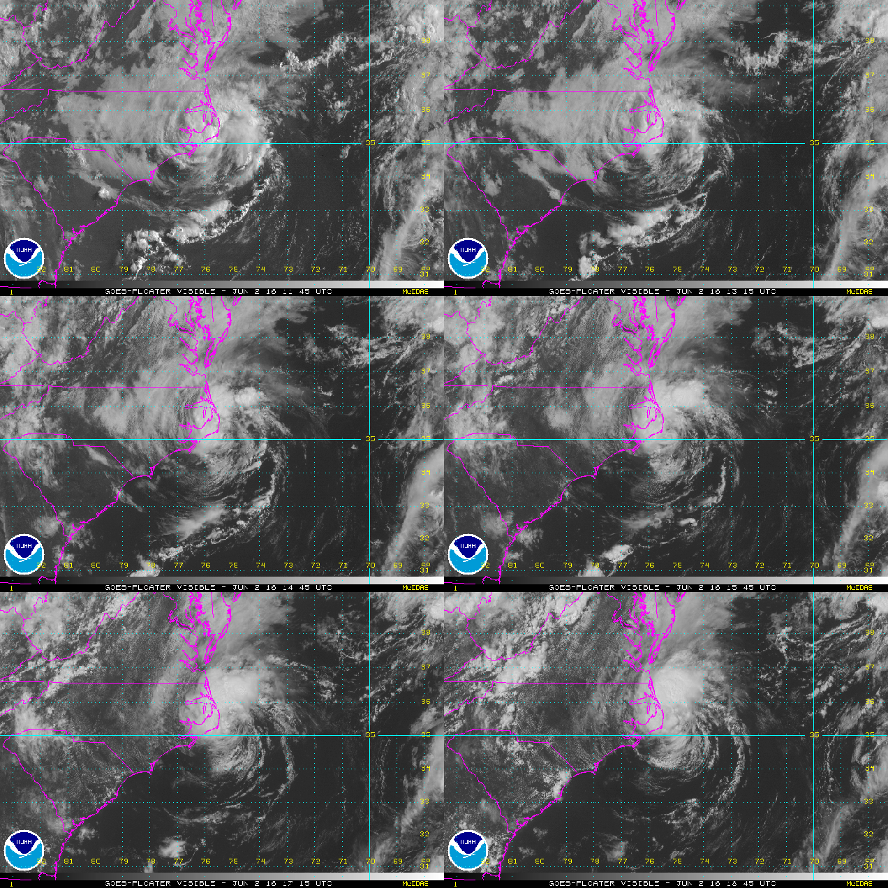
Last week, a cluster of thunderstorms moved into South Carolina, dropping up to 10 inches of rain on the Southeast. The National Hurricane Center named this cluster Tropical Depression Two, and then for some inexplicable reason, started calling it Tropical Storm Bonnie. The system moved inland, dropped a bunch of rain on the region, and just meandered around the Carolinas for much of the past 4-5 days. Last night, the circulation center moved off the the North Carolina coast, and thunderstorms started to flare up near the center. This was the healthiest the system had looked since it was first “named”.

vis_lalo-animated
Bonnie actually looks like a Tropical Depression now. Loop provided by NOAA.

Once it became obvious that this system finally looked like an actual tropical depression, the Hurricane Center started issuing advisories on the storm (again). As of 11am Thursday, “Bonnie” was centered about 25 miles east-southeast of Cape Hatteras, NC, moving towards the northeast at 7mph. Maximum sustained winds are near 30 mph, and some strengthening is possible over the next day or so as the storm moves over the warm waters of the Gulf Stream. The forecast is for the system to head in a general easterly direction out into the open waters of the Atlantic, posing a threat only to the fish and boaters.

Once “Bonnie” is gone, the tropical threat doesn’t drop back to zero. Many of the computer models are showing the possibility of another system developing near the Yucatan Peninsula by early next weekend. The models start to develop this system as it heads into the Gulf of Mexico, then turns northeastward towards Florida.

The models then have the system cross Florida and move into the Atlantic, before heading out to sea. Some additional strengthening is possible once the system moves back out over water. If the system does get strong enough, it would be named Colin.

Meanwhile, in the Eastern Pacific, things have been quiet for the 1st few weeks of the season, but that appears to be changing as well. An area of thunderstorms about 950 miles south-southwest of Cabo San Lucas, Mexico has been showing signs of development for the past few days.

ir_lalo-animated
This could be the first tropical depression of the season in the Eastern Pacific. Loop provided by NOAA.

This system should continue on a general west to west-northwesterly track for the next few days. Some strengthening is expected, and the system could become a tropical depression in the next day or two. If the system does continue to strengthen into a tropical storm, it would be given the name Agatha.

Remember, this is just the start. The peak of hurricane season is still three months away.