By now, you’re probably wondering why the weekly outlook hasn’t been posted, especially since it was snowing. Here at StormHQ, we’re taking a little time off, for a vacation in the tropics. Don’t worry, we’ll be back next week. Until then, enjoy the snow (or complain about it), while we enjoy sunshine and temperatures in the 80s in Florida and the Bahamas.
Weekly Outlook: November 28-December 4, 2016
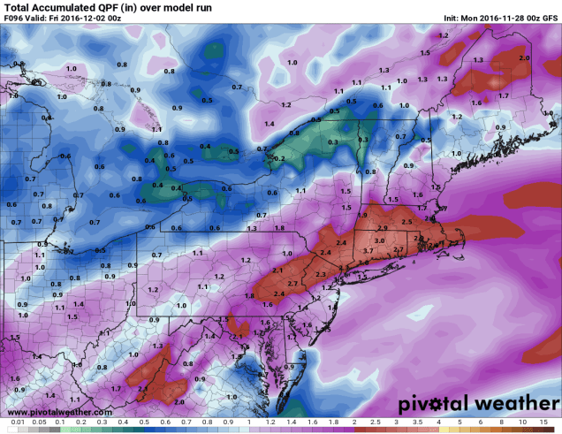
Here we are, in the final days of November and the beginning of December, ad we’re staring at not one but two storms this week that could bring us heavy precipitation. Of course, that precipitation will be nearly all rain, but we definitely need it, as we’re still in the midst of a drought.

The week starts off on a sunny but chilly note thanks to high pressure. You’d better enjoy that sunshine though, because once it disappears behind afternoon clouds, you won’t see it again until Thursday. The first storm system moves through on Tuesday, giving us a good dose of rainfall. Things could be tricky to start though. The rain may arrive before daybreak on Tuesday. With cool weather still in place, temperatures may be close to freezing across central and southern New Hampshire when the rain arrives. This could result in a little freezing rain in some areas, so you may want to be careful heading out the door early Tuesday morning. Temperatures should be above freezing across the region by late morning, ending any potential icing threat. South of Boston, it could be a much different story. Gusty southerly winds could send temperatures well into the 50s on Tuesday. The rain tapers off and ends Tuesday evening, but the next storm will be quickly approaching from the west. This storm will likely head up the St. Lawrence Valley, keeping the entire region mild, but with another round of heavy rain late Wednesday into Thursday morning. Colder air settles in behind that storm, and with an upper-level low pressure area moving through, we could see a few rain or snow showers on Friday. High pressure then builds in for the weekend with dry and cool conditions.
Monday: Plenty of sunshine, dimmed by afternoon cloudiness. High 39-46.
Monday night: Becoming cloudy with rain developing towards daybreak, possibly starting as some freezing rain in central and southern New Hampshire. Low 28-35.
Tuesday: Rain likely, possibly heavy at times. Becoming breezy along the south coast. High 45-52 north of Route 2, 52-59 south of Route 2.
Tuesday night: Mostly cloudy with rain tapering off and ending in the evening. Low 39-46.
Wednesday: Cloudy and becoming breezy with rain redeveloping by midday. High 48-55.
Thursday: Any lingering showers ending in the morning, otherwise becoming partly sunny and breezy. High 48-55, except 55-60 south and east of I-95.
Friday: A mix of sun and clouds, slight chance for a rain or snow shower. High 43-50.
Saturday: Partly sunny. High 39-46.
Sunday: Intervals of sun and clouds. High 37-44.
We do need to keep an eye on the start of the following week. Most of the models are indicating that a storm system may impact the region Monday into Tuesday. However, there is very little agreement among the models on how strong the storm might be, how heavy the precipitation might be, and what type of precipitation may fall. So, we’re not going to go into any more details at this time. We’re just giving you the heads up to keep an eye on future forecasts.
Thanksgiving Forecast
(borrowed from Elliot Abrams)
Turkeys will finish thawing Thanksgiving morning, then warm in the oven to a high near 190 in the afternoon. The kitchen will turn hot and humid, and if you bother the cook, be ready for a severe squall or a cold shoulder.
During the late afternoon and early evening hours, the cold front of a knife will slice through the turkey and cause it to accumulate 1-2 inches on plates. Mashed potatoes will drift across one side while cranberry sauce creates slippery spots on the other, especially if it mixes in as you turn to the green bean casserole. Please pass the gravy.
A weight watch has been issued for the entire area and we expect intervals of indigestion, with increasing stuffiness around the beltway. During the evening the turkey will diminish and taper off to leftovers and drop to a low of 34 in the refrigerator.
Looking ahead to Friday and Saturday: high pressure to eat sandwiches; flurries of leftovers can be expected both days with a 50% chance of scattered soup during the midday hours. We expect a warming trend baste on where soup develops.

Weekly Outlook: November 21-27, 2016
If you’re planning to head “over the river and through the woods to grandfather’s house” for your Thanksgiving dinner, well, you won’t need a sleigh to get there. You will probably need a coat and maybe an umbrella too.
If the snowflakes that many of us saw Sunday evening weren’t enough of a hint, the wind chill when you step outside today will be a bigger one – we’re moved into a colder pattern. Don’t worry, there still aren’t any big snowstorms in the immediate future, but there also aren’t any days where you can walk around in shorts and be comfortable.

We start the week off with low pressure moving across Northern New England and into Atlantic Canada. This will result in blustery (there’s a word you only hear used in the winter) and cool conditions for Monday and Tuesday. A few more snow showers are possible on Monday as an upper-level low pressure area swings through the region.High pressure briefly builds in for Wednesday, but the next storm system will be moving eastward right on its heels. Thanksgiving will be mainly cloudy with a few showers possible, and some wet snow could mix in if the showers arrive early enough in the day, mainly north and west of Boston. Black Friday starts off dry (if you’re heading out for the Midnight Specials), but another weak system will quickly approach, with more showers possible by evening, continuing into Saturday when a period of steadier rain is possible. Blustery (there’s that word again!) and cool conditions return on Sunday.
Monday: Intervals of clouds and sunshine, windy, chance for a few snow or rain showers. High 33-40.
Monday night: Partly cloudy to clear, breezy. Low 26-33.
Tuesday: Partly to mostly sunny, still breezy. High 36-43.
Tuesday night: Mostly clear skies. Low 25-32.
Wednesday: A sunny start, then clouds return in the afternoon. High 37-44.
Thursday: Mostly cloudy with a chance of showers, possibly mixed with some wet snow early in the day. High 39-46.
Friday: Plenty of clouds, chance for a few showers, especially late in the day and at night. High 43-50.
Saturday: Rain tapers off to showers before ending late in the day. High 42-49.
Sunday:A mix of sun and clouds, breezy. High 40-47.
Before you complain about how cold it is, just remember, it could be a LOT worse. Over in Siberia, Mongolia, and Kazakhstan, temperatures today will be 20 to 40 below zero. That’s 30 to 50 or more degrees below normal. Our temperatures, while chilly, will “only” be 10-15 degrees below normal today.

Winter Finally Is Arriving in the Plains
Just in time for Thanksgiving, it looks like all the ingredients are in place for Mother Nature to cook up a Plains Blizzard.

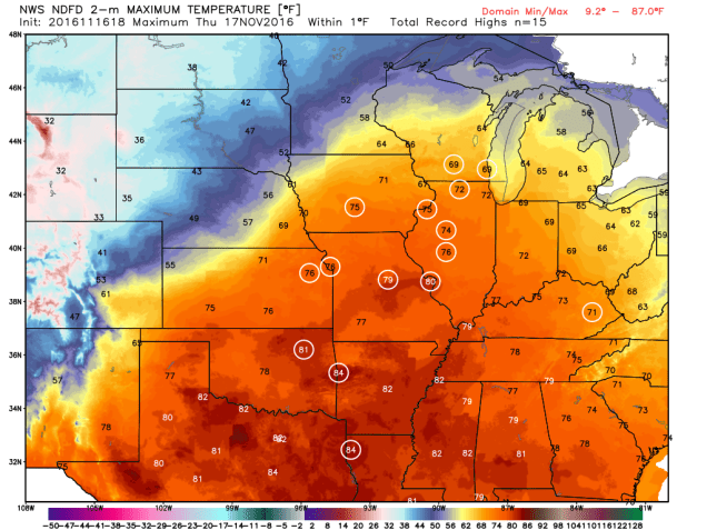
A storm system will move out of the Rockies and across the Plains states over the next few days. Ahead of the system, warm, moist air will be drawn northward from the Gulf of Mexico. High temperatures on Thursday will be in the 70s as far north as Chicago and Des Moines, with record high temperatures expected across much of the Mississippi Valley. The warmth won’t last too much longer though, as a strong cold front will be marching eastward across the Great Plains.
Behind the front, much cooler air will settle southward from Canada. With plenty of moisture being drawn northward, it will fall as snow on the backside of the low from the Central Rockies and Central Plains northeastward into the Upper Midwest. Some of the snow could be heavy, especially in parts of South Dakota and Minnesota, where snowfall totals of 10-15 inches are expected by Saturday evening, with some heavier amounts possible. As you might expect, Winter Storm Watches have been posted from eastern Wyoming and northern Nebraska northeastward to Minnesota.

Snow isn’t the only hazard with this system. As it strengthens, it will create strong winds across much of the Plains states. Sustained winds of 20-30 mph with gusts to 50 mph or more are expected, especially from the Dakotas into Nebraska. The combination of high winds and snow may result in blizzard conditions at times. A blizzard watch has been issued for southwestern Minnesota, northeastern South Dakota, and extreme southeastern North Dakota.

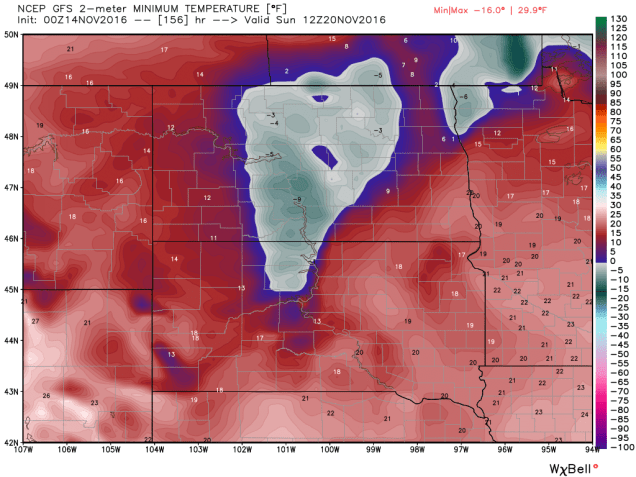
Once the system moves into southern Canada this weekend, some of the coldest air so far this season will settle into the region. While these temperatures aren’t that unusual for late November, they will be quite a change from the recent warmth that has enveloped the area. Low temperatures will likely drop into the teens and 20s across the region this weekend, with single digits possible. In some of the locations with fresh snowcover some sub-zero readings are possible. The cool air will be short-lived, as temperatures will likely warm back up to above normal readings by early next week. Current indications are that the unseasonably mild weather will persist for the most part well into December across the region.
As the system heads up into Canada, it will drag a strong cold front across our region on Sunday. Enjoy the mild air for the next few days, because things will change by late Sunday. In fact, on Monday, with temperatures expected to stay in the upper 30s and 40s at best, and some precipitation around thanks to an upper-level low pressure area, we could see some wet snowflakes falling. We’re not expecting any accumulation right now, because the ground is still much too warm, but we’re not going to rule out seeing snow showers at this point.
Weekly Outlook: November 14-20, 2016
Once again, we’ve got another fairly quiet week coming up across the region, with little to talk about. That’s a good thing, because we’re into the middle of November now, and it’s only a matter of time until things get more complicated. (Don’t worry, we’re not going to use the S-Word).

We start the week off with high pressure in control, giving us a sunny, mild day today. Tuesday is the complicated day of the week. A storm system will move up the coast, giving us some rain and cooler temperatures, mainly north of Boston. Of course, “cooler” is a relative term, as even though Tuesday will be about 10 degrees cooler than Monday, we’ll still be near or a little above normal for mid-November. South of Boston, temperatures could spike back into the 50s to near 60 again on Tuesday, depending on the exact track the storm takes. Once the storm goes by on Wednesday, high pressure builds back in, with drier weather for much of the remainder of the week, along with another warming trend. In fact, we wouldn’t be surprised at all if temperatures on Friday and Saturday ended up even warmer than what we have in the forecast below. Another system moves in this weekend with some showers and cooler conditions, but again, things could be a lot worse at this time of year.
How much worse could it be? Consider this. The cold front that will give us showers over the weekend will be extending southward from a storm moving into northern Quebec. Before it gets there, it will be quite a strong storm moving across the Nation’s mid-section later this week. It will likely produce blizzard conditions across the Dakotas, with heavy snow, wind gusts in excess of 50-60 mph, and very cold temperatures. How cold? How does sub-zero low temperatures sound next Sunday morning with 1-2 feet of fresh snow cover sound? Aren’t you glad that you don’t live in Bismarck, North Dakota?

Monday: Mostly sunny for much of the day, clouds start to filter in by evening. High 57-64.
Monday night: Becoming cloudy, showers developing towards daybreak along the south coast. Low 36-43.
Tuesday: Cloudy and breezy with showers likely, thought a few pockets of steadier and heavier rain are possible. High 47-54 north and west of Boston, 54-61 from Boston southward.
Tuesday night: Cloudy with showers tapering off and ending. Low 44-51.
Wednesday: Morning clouds give way to increasing afternoon sunshine. High 53-60.
Thursday: Mostly sunny. High 50-57.
Friday: Plenty of sunshine. High 52-59.
Saturday: Mostly sunny to start, then clouds start to increase late in the day. High 50-57.
Sunday: Mostly cloudy with a chance of showers. High 47-54.
Weekly Outlook: November 7-13, 2016
The votes are in – most of this week will feature some decent weather. However, it’s not all good news. Mother Nature has elected to remind us that it’s November, and it looks like we’re going to have our inaugural visit of arctic air next weekend.
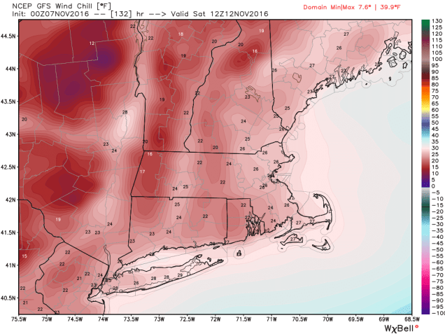
We’ll start the week with high pressure giving us sunshine and cool temperatures on Monday. As the high slides offshore, we’ll warm up on Tuesday. A weak cold front moves through on Wednesday, but we’ll only see a few showers with the front. High pressure returns for Thursday and Friday before the next cold front comes through Friday night. Then, we get to the weekend. Hope you’ve got your heavier jackets out of the closet, because you’ll need them. Gusty northwest to northerly winds will not only bring in some of the coldest air so far this season, they’ll also re-introduce a phrase you haven’t heard in several months – “wind chill”. Oh, and there’s even the chance for a few rain or snow showers (yes, we said the s-word).
Monday: Plenty of sunshine. High 46-53.
Monday night: Clear skies. Low 28-35.
Tuesday: Mostly sunny and milder. High 57-64.
Tuesday night: Increasing clouds. Low 38-45.
Wednesday: Mostly cloudy with some afternoon showers possible. High 53-60.
Thursday: Partly to mostly sunny and breezy. High 46-53.
Friday: A sunny start, then clouds move in, becoming windy. High 50-57.
Saturday: Intervals of sun and clouds, windy, chance for a rain or snow shower. High 38-45.
Sunday: Partly to mostly sunny. High 43-50.
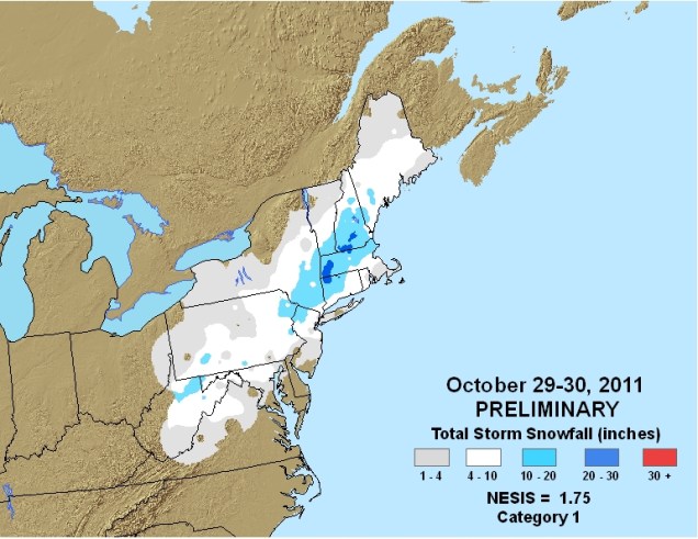
If you’re worried about an early season snowstorm, you can stop. There doesn’t appear to be anything of note to worry about over the next couple of weeks. It’s fairly rare to have a snowstorm this early in the season around here. Sure, there are a few examples (Snowtober 2011, Veterans Day 1987), but normally, you need to get into late November, or more likely December, before we get a true “snowstorm” around here. For now, we only have to worry about the crapstorm known as the Election for 2 more days.

Weekly Outlook: October 31-November 6, 2016
There’s nothing spooky about the forecast this week. Most of the week will be a treat, with very little in the way of tricks.OK, now that we’ve got the requisite back Halloween puns out of the way, we can get to the actual forecast.
High pressure will keep the region dry today and Tuesday. A weak system passes by to the north Tuesday night and Wednesday, bringing in some clouds, but it doesn’t look like we’ll see any precipitation.While we’ll be cool today and tomorrow, we will start to warm up on Wednesday. While Thursday will also be warm, we’ll be dealing with rain by afternoon as a cold front approaches the region. The rain will continue into Thursday night, but be gone by the time you wake up Friday morning. High pressure returns for Friday and Saturday with cool conditions returning. Another weak system comes through on Sunday, with some additional showers expected.
Considering how bad things can get around here for Halloween, this week’s forecast isn’t that bad. Just 4 years ago, we were cleaning up after Sandy. Just one year earlier, we were digging out from a record blizzard. Also, 25 years ago, the so-called “Perfect Storm” was battering the region.
Monday: Becoming mostly sunny and breezy. High 45-52.
Monday night: Mostly clear skies. Low 28-35.
Tuesday: Sunshine and a few clouds. High 50-57.
Tuesday night: Partly cloudy. Low 38-45.
Wednesday: Intervals of clouds and sunshine. High 61-68.
Thursday: Cloudy and breezy with rain likely in the afternoon and evening. High 63-70.
Friday: Partly to mostly sunny. High 46-53.
Saturday: A mix of sun and clouds. High 47-54.
Sunday: Mostly cloudy with a chance for a few showers. High 45-52.
Snow in the Forecast? Not for Most of Us
By now, you’ve probably heard from your favorite TV meteorologist that there’s snow in the forecast for Thursday. While parts of the region will likely see some snow on Thursday, the vast majority of us will not.
High pressure will provide us with some chilly weather for the next few days. Temperatures will likely dip near or below freezing across much of the area tonight and again Wednesday night. So, we’ve got cold air in place, and a storm system heading our way on Thursday. That means it’s going to snow, right? As famed college football analyst Lee Corso would say “Not so fast my friend”. Allow us to explain.
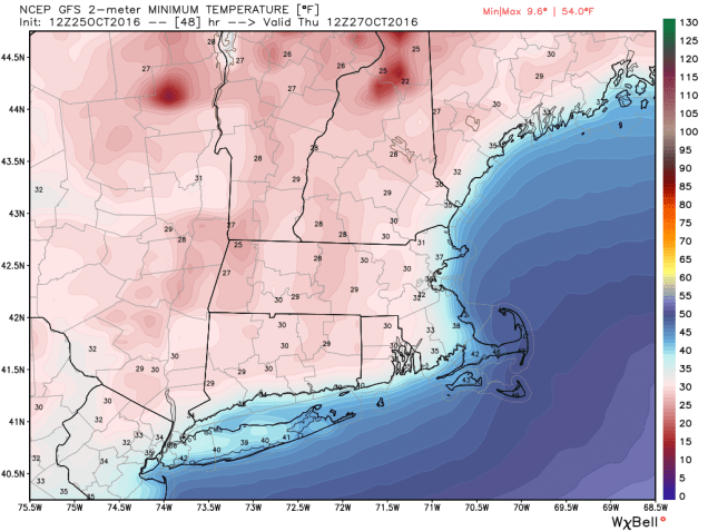
As that high pressure area moves off to the east, winds will shift into the east and southeast across the region. Water temperatures off the coast are still in the 50s to lower 60s, so a wind off the water will allow temperatures to moderate. Thursday will still be a chilly day, with temperatures mainly in the 40s, but the air will remain dry, thanks to the high pressure area. As the precipitation arrives from the west during the afternoon, it will fall into that dry air, evaporating before it hits the ground. This will also allow temperatures to drop through a process called evaporational cooling. Temperatures may drop into the upper 30s to lower 40s before the air moistens up enough for the precipitation to hit the ground.

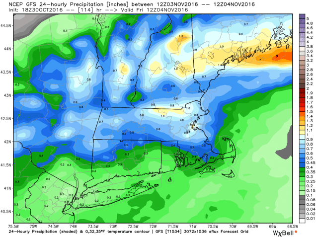
With temperatures likely near or just above 40, we’re looking at mainly rain across most of our region. Oh sure, there could be a renegade snowflake or ice pellet mixed in at the start across parts of southern NH or central MA, but for the most part, we’re looking at rain, and possibly a decent amount of it. Much of the region could receive between 0.75″ and 1.50″ of rain from this system, which will help put a dent into the ongoing drought.
Farther to the north and west, especially across the higher elevations of the Berkshires, Monadnocks, and the mountains of Northern New England, temperatures will be cooler, and the precipitation will arrive faster, thus increasing the chances that it starts as snow. Even in these locations, warmer air will move in Thursday night, allowing the snow to change over to rain. Before that happens, we could see a little accumulation, especially at the higher elevations, where a few inches may accumulate. The best chance for accumulating snow actually looks to be across the Adirondacks of northeastern New York, where the warm air will have a tough time getting in.
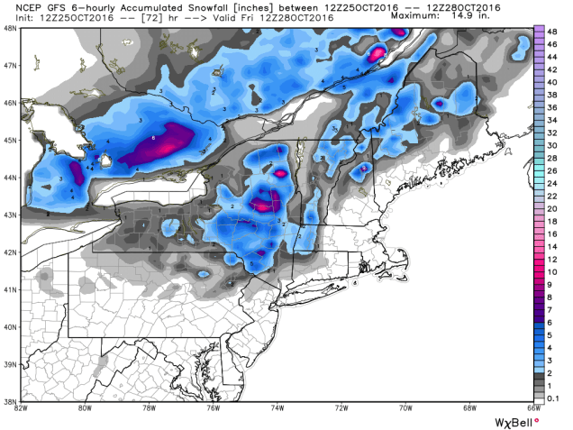
Once we get past this system, we could be looking at a wet weekend and start of next week. A couple more storms may move across the region, bringing us several bouts of much-needed rainfall. It does not look like there will be more snow with these systems, except possibly across the mountains of northern New England.
Weekly Outlook: October 24-30, 2016
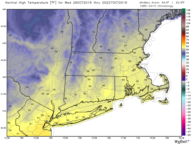
In the past several days, we’ve had 80-degree temperatures setting record highs, torrential downpours leading to flooding, several inches of snow across the higher elevations, and wind gusts to 60 mph across the region. Believe it or not, there’s a technical term for all of this: “October” While we’re still in October, things will be a lot less volatile during the upcoming week.

We’ll start the week off with a little bit of rain as a weak system moves across the region. The rain will be mainly confined to areas south of the Mass Pike, and should be all done before many of you get to work Monday morning. It will remain windy into Tuesday as the storm that brought us the heavy rain Friday continues to sit and spin across southeastern Canada. High pressure then builds in, giving us dry but rather cool conditions for mid-week.The next system gives us some rain Thursday into early Friday. While there could be some downpours, we’re not looking at anything like what we saw Friday night. High pressure then builds in for the weekend, but another storm looks to approach late Sunday night and into Halloween. Right now, it looks like the rain will be out of here in time for trick-or-treaters, but we’ve got plenty of time to keep an eye on that system.
Monday: Showers in the morning, then becoming partly sunny and windy in the afternoon. High 52-59.
Monday night: Clear to partly cloudy and breezy. Low 32-39.
Tuesday: Partly to mostly sunny, still breezy. High 43-50.
Tuesday night: Clear skies. Low 29-36.
Wednesday: Sunshine and a few clouds. High 41-48.
Thursday: Becoming mostly cloudy with showers developing late in the day, becoming a steady rain at night. High 46-53.
Friday: Rain ending in the morning, then becoming partly sunny and breezy. High 53-60.
Saturday: Mostly sunny. High 50-57.
Sunday: Becoming mostly cloudy with showers developing at night. High 48-55.
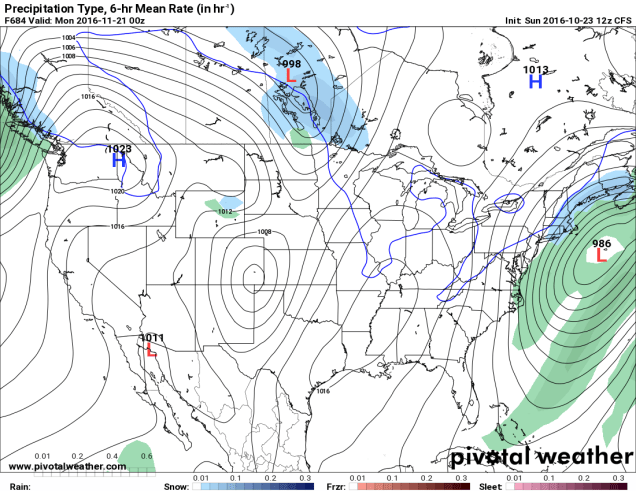
Finally, since we’re getting to the time of year where people start wondering when the snow will start to fall around here, we figured we’d try to answer that. Now, we understand that some of you ask this question because you love winter, and some ask because you dread it and want to know when your luck will run out. There’s a model called the CFS, that actually goes out several months. We put zero stock in this model, and are only presenting it for entertainment purposes only. In other words, the odds that this model is right are roughly the same odds that the Cubs win the World Series the Jets win the Super Bowl this year.