It’s been a warm and dry summer for most of the region, but the next few days will feature some very hot weather and unlike much of the summer, some extreme humidity.
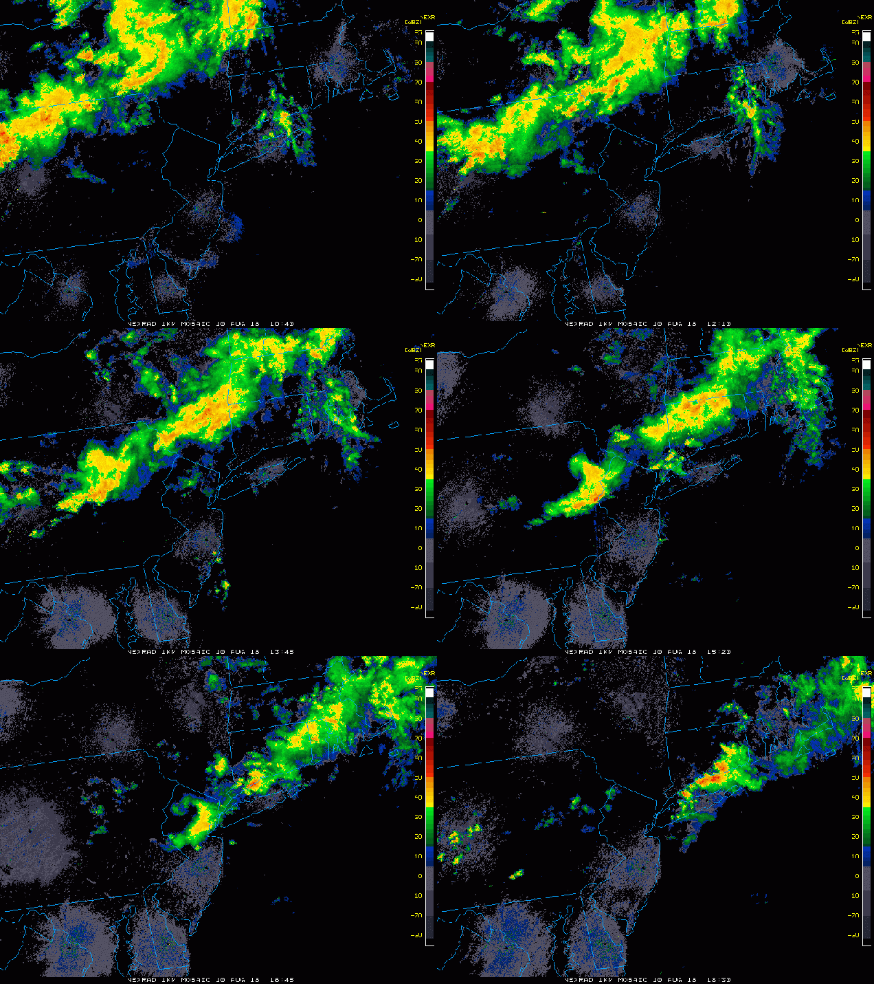
Some much-needed rain fell across Southern New England today. Loop provided by the College of DuPage.
A weak upper-level disturbance moved across the region this morning, bringing some much needed rainfall to the region. The cloud cover and rainfall has kept temperatures mainly in the 70s to lower 80s, but dewpoints have jumped into the upper 60s and 70s across the area. That moisture is going to remain in place for the next several days, but will be accompanied by some very hot weather.
Once some patchy fog burns off Thursday morning, we;ll have sunshine across the area. Since we’re going to start the day in the 70s, temperatures will quickly spike into the 80s and 90s by midday. South to southwest winds will keep temperatures in the 80s along the south coast, but elsewhere, highs will soar well into 90s. When you factor in the humidity, the heat index will be near or just over 100 degrees. As a result, a heat advisory has been issued for much of eastern Massachusetts from Noon until 7pm on Thursday. If your plans include outdoor activities, make sure you follow the usual precautions – drink plenty of liquids and stay out of the sun as much as possible.
Heat index forecast for Thursday afternoon. Image provided by the National Weather Service.
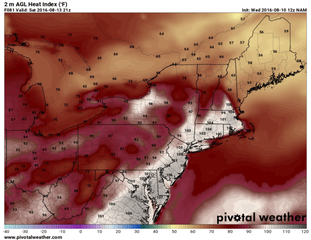
Thursday isn’t the only hot day though, and in fact, it might not even be the hottest day this week. Friday will feature conditions similar to Thursday, but Saturday could be even hotter. Temperatures will soar well into the 90s once again, with heat indices topping 100 across much of the region.
Heat index forecast for 5pm Saturday based on the NAM model. Image provided by Pivotal Weather.
While some showers and thunderstorms may pop up both Friday and Saturday afternoons to provide a little relief from the heat, it’s an approaching cold front that will bring an end to the heat wave. When that front arrives is still a big question mark. Some models want to bring the front through the region Saturday night, while others wait until later on Sunday. This obviously has a big impact on temperatures for Sunday across the region. What the models all agree on is that the front will stall out near the area at some point on Sunday, and then waves of low pressure will ride along the front. South of the front temperatures will still be in the 80s to lower 90s with fairly high humidity, while north of the front temperatures will be in the 70s to lower 80s with lower humidity. The waves riding along the front will likely bring in some beneficial rainfall later Sunday into Monday, before the front finally pushes farther to the south. Neither day should be a washout, but we certainly need the rain. We’ll have more details on that later in the week as things become a little clearer.
Looks like we’ve got a typical summer-time week on our hands. Warm temperatures, increasing humidity, late-day showers and thunderstorms – they’re all in the forecast.
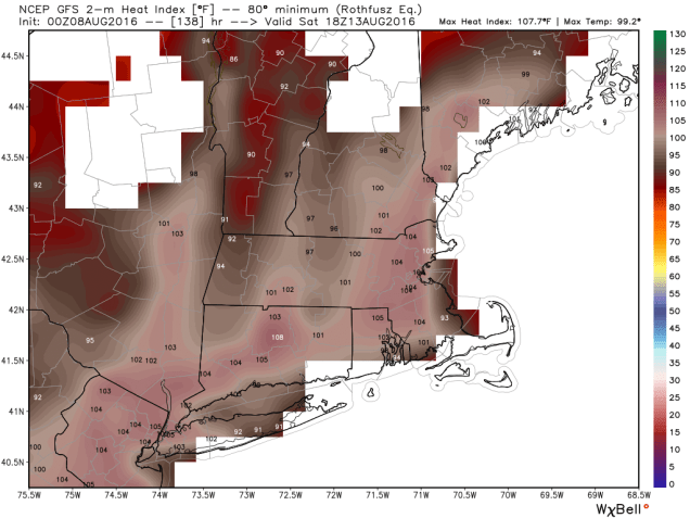
We start the week with high pressure building in from the Great Lakes. That gives us sunshine, warm temperatures, and low humidity for Monday and Tuesday. By Wednesday, the high slides offshore. This allows winds to become southwesterly, bringing even warmer weather in, but also more humidity. With the humidity will also come an increased risk of afternoon showers and thunderstorms, especially Thursday and Friday. By the end of the week a front will start to approach from the north.This will give us an even better chance of showers and thunderstorms next weekend, but right now, neither day looks likely a washout. Cooler and drier weather is likely behind the front, but when that front moves through is a big question mark. One model wants to wait until Monday, with Sunday being hot and humid once again, while another brings it through early Sunday, with significant cooler temperatures Sunday afternoon. For now, we’ll go in between the two, because frankly, we’re not sure which way to lean at this point.
GFS model forecast for the heat index on Saturday afternoon. We think this is a little overdone. Image provide by WeatherBell.
Monday: Sunshine and a few clouds. High 81-88.
Monday night: Clear skies.Low 57-64.
Tuesday: Mostly sunny. High 83-90.
Tuesday night: Clear to partly cloudy. Low 62-69.
Wednesday: A mix of sun and clouds, chance for afternoon showers and thunderstorms. High 81-88.
Thursday: Partly sunny, a few showers and thunderstorms are possible. High 90-97.
Friday: Intervals of clouds and sunshine with scattered showers and thunderstorms in the afternoon. High 86-93.
Saturday: Partly sunny, chance for afternoon showers and thunderstorms. High 88-95.
Sunday: More clouds than sunshine with a chance for more showers and thunderstorms. High 80-87.
A persistent pattern over the last several months has left much of Northeast in a drought. According to the most recent update from the National Drought Monitor, portions of Western New York and also Central New England are experiencing severe drought.
Update from August 2 on drought conditions across the Northeast, Image provided by NOAA.
Heavy showers and thunderstorms have been common across the Mid-Atlantic states recently, eliminating any drought concerns, but the bulk of the rainfall has remained well south or well north of areas that need it the most.
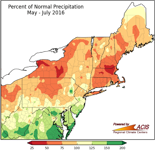
Map showing percent of normal rainfall from May 1 through July 31 across the Northeast. Image provided by the Northeast Regional Climate Center
According to data from the Northeast Regional Climate Center, the period between Marc 1 and August 2 is the driest on record for several locations across New York and New England, including cities such as Lawrence, MA, and Elmira and Batavia, NY. Other locations, such as Hartford, CT and Hingham, MA, are in the Top 5 driest March 1-August 2 on record. Many rivers and streams across the region are at near record low levels. Water restrictions and/or bans are in effect for hundreds of cities and towns across the region.
A cold front will cross the region on Saturday, producing scattered showers and thunderstorms. While some of these storms could be locally heavy, most places will receive just light rainfall, which will barely put a dent in the drought. The bigger concern on Saturday is for severe weather across the Northeast. While the timing of the front won’t be optimal for a severe weather outbreak, conditions will be favorable for some strong to severe thunderstorms, especially across Southern New England and southeastern New York during the afternoon hours. Some storms may produce strong winds along with hail and brief downpours.
GFS model forecast for rainfall through Saturday night. Image provided by WeatherBell.
Once the front moves through, high pressure builds back in with sunshine and dry conditions for the first half of the upcoming week. Another front will move through on Wednesday with a chance for some additional showers and thunderstorms before stalling out across the region. Exactly where that front stalls out will be critical, as waves of low pressure are expected to ride along it, bringing chances for some much-needed rainfall. If the front stalls along the southern New England coast, then some significant rainfall could fall across much of New York and Southern New England. If the front stalls out across the Mid-Atlantic states, then the heaviest rain would be focused there, and not where it is needed most. The forecast models are split on where the front will stall out, so it’s too early to get a good idea of which idea might be correct. However, if history is any indication, then expect the front to stall out to the south. Droughts feed on themselves, which leads to an old forecasting rule of thumb – “When in drought, leave it out“.
Normally, when the Northeast experiences a drought in the summer, it ends with heavy rainfall from a tropical system, or the remains of a tropical system that made landfall elsewhere. Tropical Storm Earl is moving into eastern Mexico this evening, but it is not expected to have any impacts on the US. However, there is a cluster of thunderstorms in the northeastern Gulf of Mexico that needs to be watched. While development of a tropical cyclone is not expected over the next few days, the system could slowly organize. The main impact from this system will be heavy rainfall across the Gulf Coast, especially in portions of Florida and southern Georgia. Some models are showing the potential for 5-10 inches of rain over the next few days. This will almost certainly lead to flooding in parts of the region.
GFS model forecast for rainfall across the Gulf Coast through Tuesday. Image provided by WeatherBell.
The ideal situation would be for some of this moisture to be drawn northward and ride along the front into the Northeast, finally bringing significant rainfall to the area. While this is a possibility, it does not seem like a likely scenario at this point. In fact, some of the models show the moisture remaining in place across the Northern Gulf of Mexico right through the week, with heavy rain and thunderstorms continuing across the region.
After a quiet July across the Atlantic Ocean, August began with Tropical Storm Earl forming southwest of Jamaica on Tuesday. Earl strengthened into a Hurricane Wednesday afternoon while approaching Central America, with landfall expected in Belize around midnight.
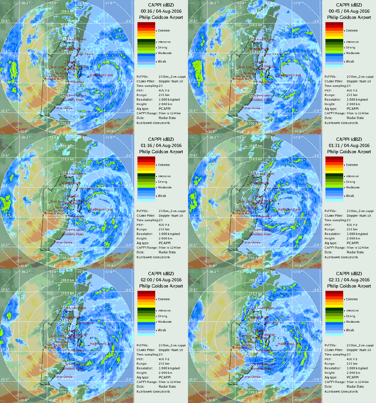
Radar loop showing the center of Hurricane Earl approaching the coast of Belize. Loop provided by the National Meteorological Service of Belize.
As of 11pm EDT, Hurricane Earl was centered about 40 miles east of Belize City, moving towards the west at 15 mph. Maximum sustained winds are near 75 mph, with little additional strengthening expected in the next few hours before Earl makes landfall.
Satellite loop of Hurricane Earl. Loop provided by NOAA.
Hurricane warnings are in effect from Puerto Costa Maya, Mexico southward to the Belize/Guatemala border. A Tropical Storm Warning is in effect from Puerto Costa Maya to Punta Allen, Mexico.
Most of the strong winds are in the northeastern quadrant of Earl, which will spare coastal locations in Honduras and Belize from significant wind damage. Right along the immediate coast, a storm surge of 4-6 feet, along with large waves will result in coastal flooding, especially near and north where the central makes landfall in Belize. The biggest threat by far is flooding and mudslides from torrential rainfall. Rainfall totals of 10-15 inches, with isolated totals in excess of 20 inches, are expected across Belize, Guatemala, and southeastern Mexico over the next few days.
GFS model forecast for rainfall over the next 4 days. Image provided by Pivotal Weather.
Once Earl moves inland, it would steadily weaken, likely being downgraded to a tropical depression by Thursday night. Earl should continue on a westward track, but the exact track will be critical for Earl’s future. If Earl remains over land, it will dissipate over southern Mexico. However, if the center can emerge in the southern Bay of Campeche, it could regain a little strength before making landfall again in Mexico.
Elsewhere in the Atlantic, things are mainly quiet. A tropical wave will bring showers and thunderstorms along with some gusty winds to the Lesser Antilles late Thursday, moving across the Virgin Islands and Puerto Rico Thursday night and Friday. Further development isn’t expected at this time.
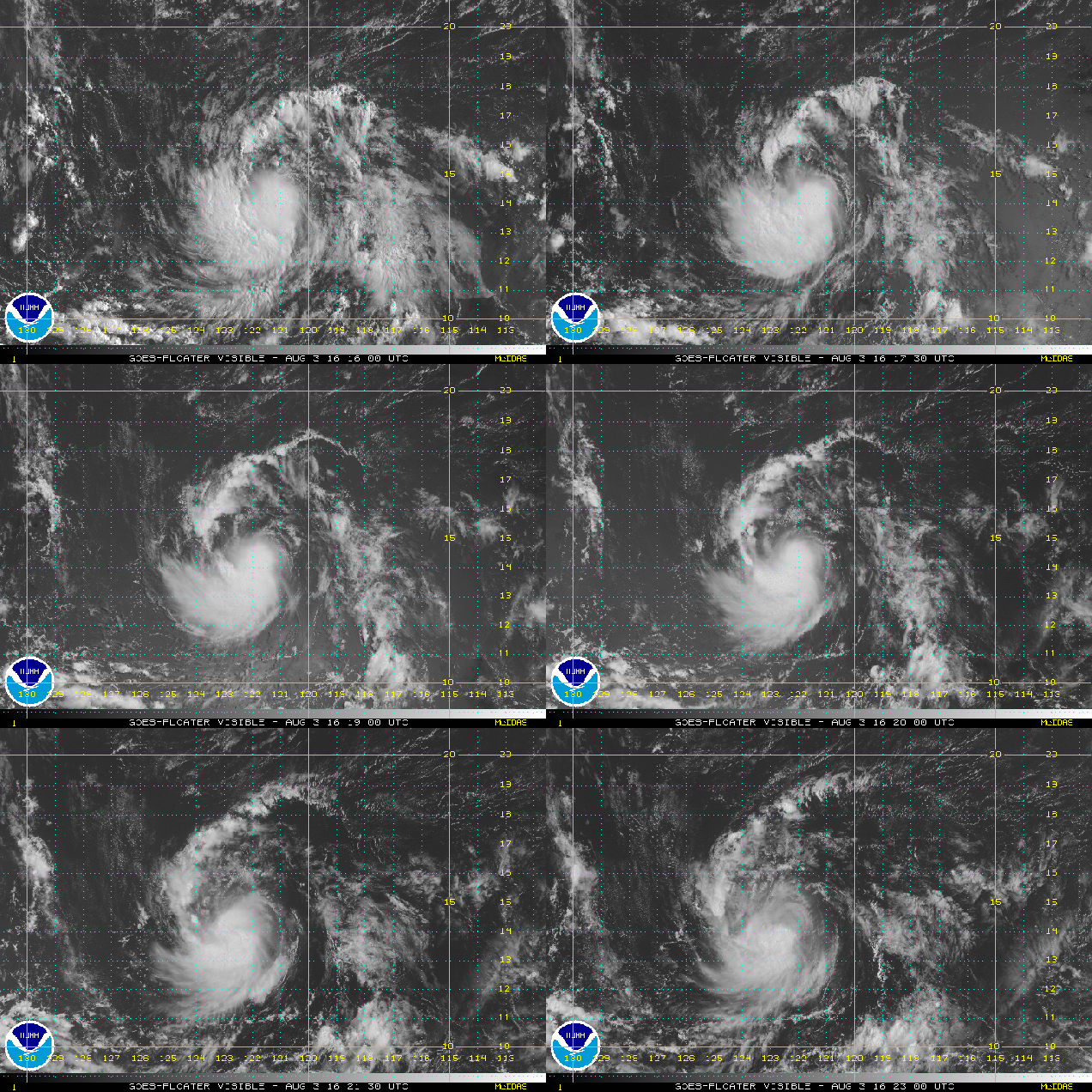
Satellite loop of Tropical Storm Ivette. Loop provided by NOAA.
Meanwhile, in the Eastern Pacific, Tropical Storm Ivette continues to gather strength this evening. As of 11pm EDT, Ivette was centered a little more than 1000 miles west-southwest of Cabo San Lucas, Mexico, moving toward the west at 16 mph. Ivette has maximum sustained winds near 45 mph, and additional strengthening is expected. Ivette could become a hurricane in the next day or two while moving over open waters in the Eastern Pacific.
A tropical disturbance southeast of Jamaica could become Tropical Storm Early on Tuesday. Loop provided by NOAA.
Now that we’re in August, the tropics are starting to get active all around the world. We’ll take a look at all of the systems out there, starting close to home.
A strong tropical wave is centered about 200 miles southeast of Kingston, Jamaica late this evening. The system is producing heavy rain and gusty winds across parts of the Dominican Republic, Haiti, and Jamaica, and these conditions will spread into the Cayman Islands on Tuesday. Although the system looks pretty good in satellite photos, it does not have a closed circulation as of yet. Once that occurs, the system will likely be upgraded to Tropical Storm Early.An Air Force Reserve Reconnaissance Aircraft will investigate the storm early on Tuesday to see if that has happened.
Computer model forecasts for the track of a tropical disturbance in the Caribbean. Image provided by Tropical Tidbits.Computer model forecasts for the intensity of a tropical disturbance in the Caribbean. Image provided by Tropical Tidbits.
Whether or not the system develops, it should continue to move in a general westward direction at a fairly fast pace for the next few days. The system will likely move across the Yucatan or Belize towards midweek. After that, if it moves into the Bay of Campeche it could strengthen some more before hitting Mexico again late in the week. One thing that is likely is that heavy rainfall will lead to flash flooding and mudslides across pparts of the Dominican Republic, Haiti, and Jamaica through Tuesday, and parts of the Yucatan and Belize later this week. For the latter locations, rainfall totals of 8-15 inches are possible, which some heavier amounts not ruled out.
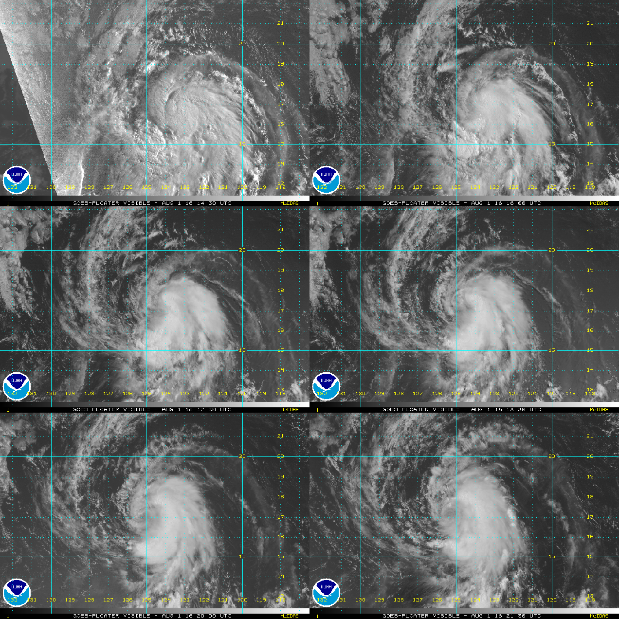
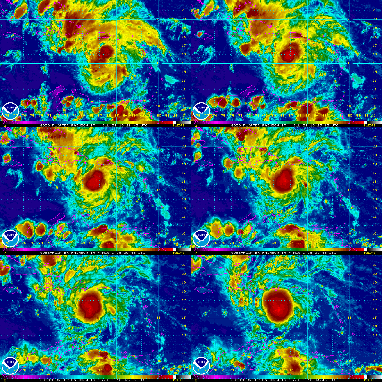
Satellite loop of Tropical Storm Howard. Loop provided by NOAA.
In the Eastern Pacific Ocean, Tropical Storm Howard is centered about 1125 miles west-southwest of Cabo San Lucas, Mexico late this evening. Howard has maximum sustained winds near 50 mph, and is moving towards the west-northwest at 14 mph. Howard is expected to continue moving toward the west-northwest or west over the next few days while steadily weakening as it moves over colder waters.
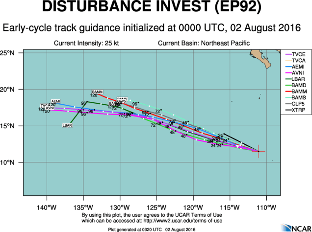
A little to east of Howard, a cluster of thunderstorms well southwest of Manzanillo, Mexico is being watched for development. Conditions look favorable for this system to develop over the next few days and it could become a tropical depression later this week. Forecast models show some steady strengthening through the week, and if the system gathers enough strength, it will be named Ivette.
Computer model forecasts for the track of a tropical disturbance in the Eastern Pacific. Image provided by NCAR.Computer model forecasts for the intensity of a tropical disturbance in the Eastern Pacific. Image provided by NCAR.
In the Western Pacific Ocean, Typhoon 06W (Nida), made landfall very close to Hong Kong earlier on Tuesday. After lashing the northern Philippines with up to 10 inches of rain on Sunday, Nida took aim at Hong Kong on Monday. It made landfall in the pre-dawn hours of Tuesday just east of Hong Kong, producing a wind gust to 64 mph at Hong Kong International Airport, and a gust to 94 mph at Ngong Ping. Nida will continue to move inland on wednesday while dissipating. Rainfall totals of 6-12 inches are possible in the region, likely leading to flooding in some areas.
Satellite loop of Typhoon Nida. Loop provided by NOAA.
August has arrived, and typically, this means the “Dog Days of Summer”. The next few days though will not feel like that around here. Oh sure, heat could make a comeback late in the week, but even then, it will be short-lived.
Total rainfall for the month of July. Image provided by WeatherBell.
After one of the driest Julys on record across the region, we’re going to start August off with some rainfall. Oh, it won’t be a lot, in fact, it’ll probably be precious little in many places, but right now, we need all that we can get. A frontal system is stalled out south of the region, and a wave of low pressure will ride along it. This will give us clouds, cool temperatures, and some showers for Monday and early Tuesday. Once the wave moves by, high pressure builds in, with drier weather for much of the remainder of the week. Temperatures will trend upwards once again, with some 90-degree readings possible late in the week. By Saturday, another cold front will be coming through, with showers and thunderstorms possible. High pressure brings drier weather again for the end of the weekend.
Rainfall forecast through Tuesday evening from the GFS model. Doesn’t look like much for our area, does it? Image provided by WeatherBell.
The other thing that August is known for is the tropics getting more active. We’ll get into more details on that with a blog post in another day or two, but currently we have a typhoon heading directly toward Hong Kong and a Tropical Depression in the Eastern Pacific. We are also watching a system in the Bay of Bengal that could threaten India, another system southwest of Mexico, and a system moving across the Caribbean. The latter one could threaten the Yucatan or Central America later this week.
Heading to Jamaica this week? Pay attention to what this does over the next day or two. Loop provided by NOAA.
Monday: Plenty of clouds with occasional showers possible. High 71-78.
Monday night: Mostly cloudy with a chance for a shower or two. Low 59-66.
Tuesday: Chance of showers early, then partial sunshine develops in the afternoon. High 72-79.
Tuesday night: Clearing skies. Low 55-62.
Wednesday: Sunshine and a few clouds. High 76-83.
Thursday: Partly to mostly sunny. High 80-87.
Friday: A mix of sun and clouds. High 85-92.
Saturday: Partly sunny with a chance of showers and thunderstorms. High 86-93.
Sunday: Becoming partly to mostly sunny. High 80-87.
For those interested in learning more the weather – the 17th annual Southern New England Weather Conference will take place on Saturday October, 29, 2016. Registration for the conference is now open. The conference is open to all, meteorologists and weather enthusiasts. Some of this year’s topics include the 25th anniversary of both Hurricane Bob and “The Perfect Storm”, how El Nino impacts New England, and Tornadoes in New England. If you’re interested, visit the website for all of the details and to register.
As we approach the end of July, tropical cyclone activity normally starts to ramp up across both the Atlantic and the Pacific. This year, that is the case once again, with one active system right now and three other areas of disturbed weather that are being monitored for development.
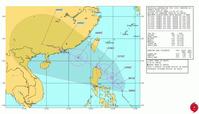
Forecast track for Tropical Depression 06z. Image provided by the Joint Typhoon Warning Center.
The only active tropical system right now is located in the Western Pacific Ocean. Tropical Depression 06W formed Friday afternoon about 450 miles east-southeast of Manila in the Philippines. The system is expected to steadily strengthen on Saturday, likely becoming Tropical Storm Nida. The current track calls for the system to become a typhoon before passing very close to northern Luzon on Sunday. This track will likely bring very heavy rainfall to northern portions of Philippines. Rainfall totals of 10 to 20 inches are possible, with some heavier amounts. Flooding and mudslides are likely across this area. After passing near or over northern Luzon this weekend, the storm will head west-northwestward into the South China Sea. A track towards southern China seems likely, with a landfall near Hong Kong possible. Flooding has been reported in southern China recently from heavy monsoonal rains, and additional heavy rain from a tropical system will likely worsen flooding in the region.
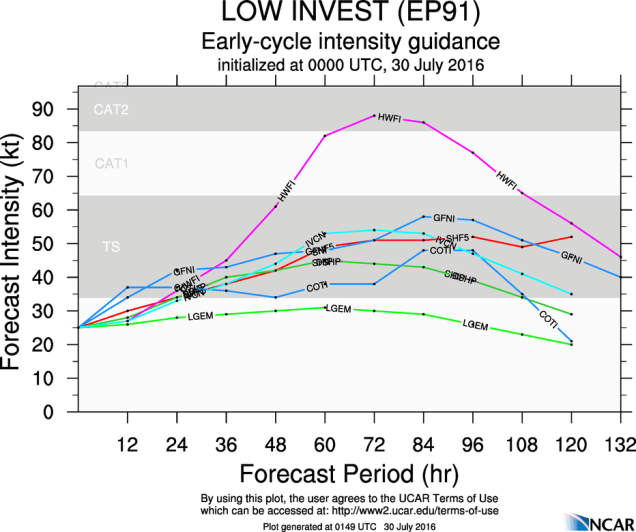
Heading eastward, a cluster of showers and thunderstorms centered about 750 miles south-southwest of Cabo San Lucas, Mexico is being watched for signs of development. Although the shower activity is disorganized right now, conditions are favorable for the development of a tropical depression this weekend. Some slow but steady strengthening is expected into early next week. The system will not be a threat to any land areas.
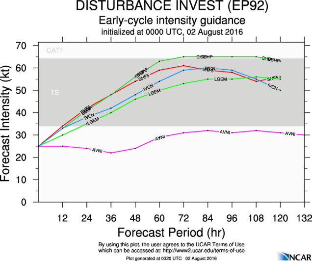
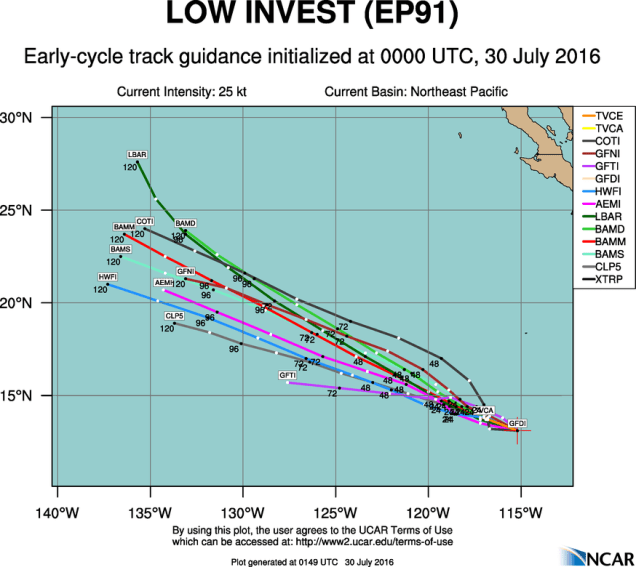
Model forecasts for the track of a tropical disturbance in the Eastern Pacific. Image provided by NCAR.Model forecasts for the intensity of a tropical disturbance in the Eastern Pacific. Image provided by NCAR.
In the Atlantic, after a record-setting start to the season, things have been quiet throughout the month of July. As we flip the calendar into August, that could change.
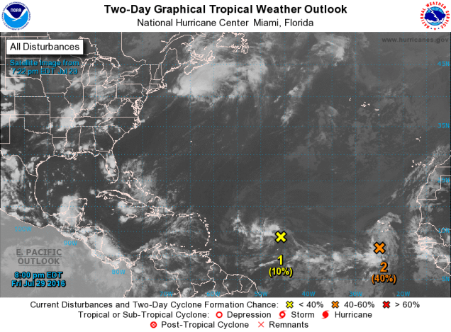
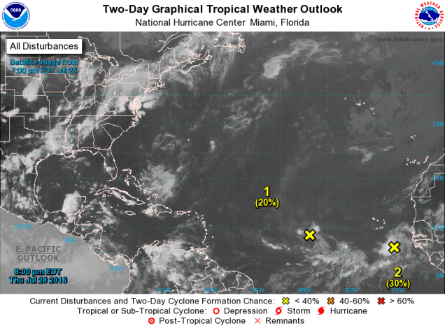
There are two disturbances in the Atlantic that are being monitored for development. Image provided by the National Hurricane Center.
During the first part of hurricane season (June/July), attention is mainly focused on the Gulf of Mexico, Caribbean, and the Bahamas for tropical development. These are the areas where water temperatures are warm enough to sustain tropical systems, but also areas where conditions are usually more favorable for systems to develop. Out across the open waters of the Atlantic, strong easterly winds can bring surges of Saharan dust off of Africa and send them across the Atlantic towards the Caribbean. This dry, dusty air inhibits the development of thunderstorms. As we get into August, the easterlies usually calm down a bit, and tropical waves start rolling off of Africa every few days. Some of these waves look impressive as they exit the coast, with plenty of shower and thunderstorm activity, only to quickly collapse when they hit the colder waters right off the coast of Africa. Others survive that part of the trip and make their way across the Atlantic. The ones that develop quickly into tropical systems are known as “Cape Verde Storms”, since the often form not far from the Cape Verde Islands. With plenty of time to cross the Atlantic, some of these storms are the most powerful storms we’ve seen.
Location of all tropical storms and hurricanes that formed between July 21 and 31 during the years 1851-2009. Image provided by the National Hurricane Center.
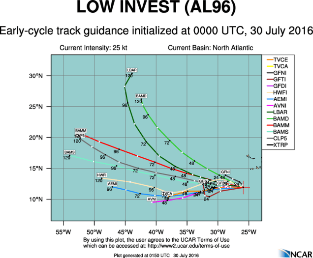
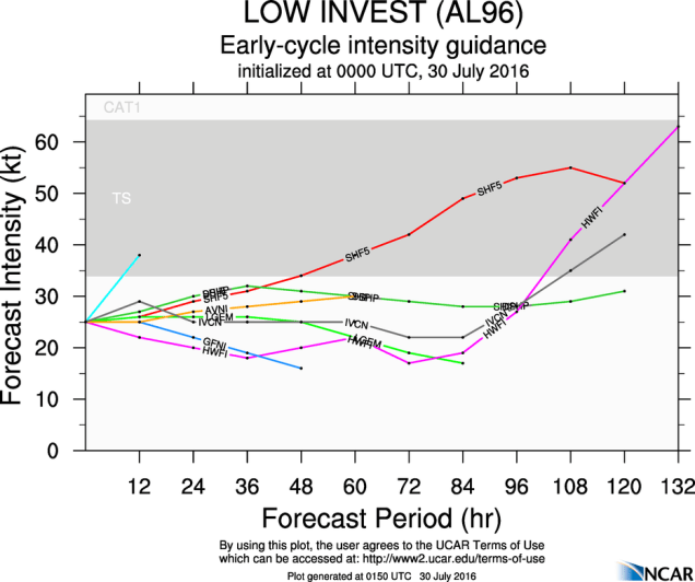
Right now, there are two areas of disturbed weather we’re watching in the Atlantic. One of these is a cluster of thunderstorms passing south of the Cape Verde Islands. Although the system is disorganized at the moment, conditions are favorable for some development this weekend. As we head into the beginning of next week, conditions look less favorable. Most of the forecast models indicate that the system should remain weak, if it develops at all, and remain over open waters, with no threat to any land areas.
Model forecasts for the track of a tropical disturbance near the Cape Verde Islands. Image provided by NCAR.Model forecasts for the track of a tropical disturbance near the Cape Verde Islands. Image provided by NCAR.
The second disturbance is the one that bears watching, and will have impacts on land areas. A tropical wave is centered about 1000 miles east of the Lesser Antilles this evening, producing disorganized showers and thunderstorms. The wave is moving along rather quickly (around 20-25 mph), and this fast motion will likely preclude much development over the weekend. The wave will bring showers and thunderstorms along with gusty winds to the islands of the eastern and northeastern Caribbean this weekend. Parts of this region are still recovering from a drought, so the rainfall will be welcome. As this system moves into the Caribbean, we’ll need to keep a close eye on it. Some models have the center of the system pass north of the islands, and towards the Bahamas, some have it pass directly over the islands, and others have it pass south of the islands and across the Caribbean, then possibly towards the Gulf of Mexico. The exact track it takes will determine whether it has a chance to develop or not. At this time, it’s far too early to tell which way it will go, so we’ll need to keep an eye on it.
Model forecasts for the track of a tropical disturbance in the Central Atlantic. Image provided by NCAR.
As we head into August, tropical activity should continue to ramp up across the Atlantic and the Pacific as we head towards the peak of the season, which is usually from late August to late September.
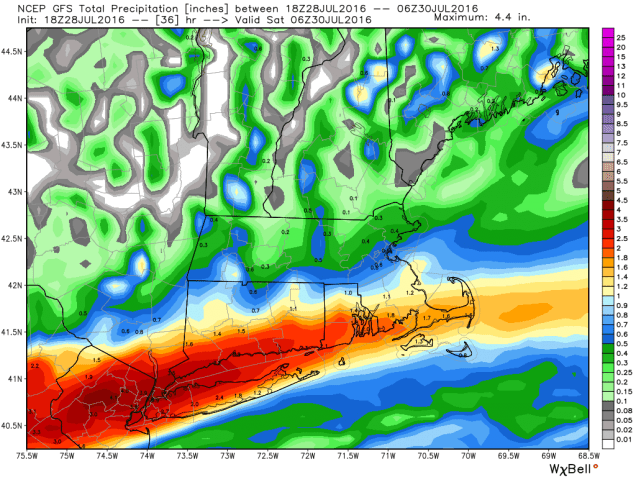
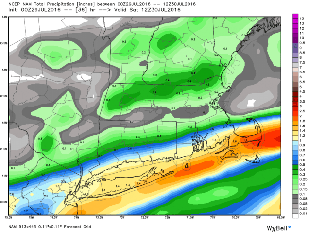
Last night, we told you about the old adage “When in Drought, Leave It Out.” Well, a lot of meteorologists around here decided to ignore that because many of the computer models were forecasting heavy rain across Southern New England on Friday. If you checked out a forecast anywhere on TV, Radio, or the Internet, all you heard was that heavy rain was expected on Friday. However, our forecast, along with the one from our comrades at Woods Hill Weather, was for most of the heavy rain to remain to our south. Well, most of the computer models started leaning that way today as well, and all of the other forecasts started to backpedal off of their “heavy rain” forecasts.
GFS model forecast for rainfall through early Saturday morning. Image provided by WeatherBell.NAM model forecast for rainfall through early Saturday morning. Image provided by WeatherBell.
As you can see in the maps above there will be a sharp cutoff from heavy rain to very little rain across the region. We’re confident that heavy rain will fall along the south coast on Friday, and we’re fairly confident that the heavy rain shouldn’t make it as far north as Boston. Areas in between Boston and Providence? That’s a toss-up. A Flash Flood Watch is in effect for most of Southeastern Massachusetts, Rhode Island, and Connecticut through Friday evening. Some flooding is likely with some of the heavier downpours, especially in some of the places that usually experience flooding in heavy rain. Unfortunately, not much rain is expected in the areas that really need it, especially the Merrimack Valley.
In yesterday’s post, we also mentioned the possibility of the tropics heating up. We told you about the tropical disturbance that was being watched in the eastern Atlantic. Well, we’re still watching it today, but we also have our eyes on a second area of disturbed weather out there.
We have not one, but two disturbances to keep an eye on now. Image provided by the National Hurricane Center.
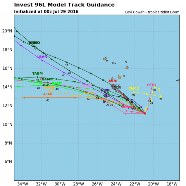
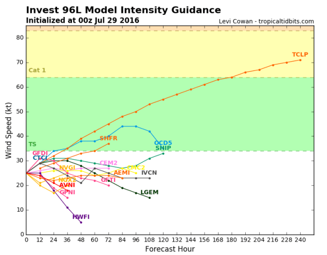
The first disturbance is passing south of the Cape Verde Islands this evening. It remains weak, but conditions are favorable for some development over the next few days. However, that window of opportunity will likely start to close as the system gets into the central Atlantic by the end of the weekend. Most of the forecast models don’t expect much development of this system, and frankly, neither do we. It’s something to keep an eye on through the weekend, but we’re not expecting much.
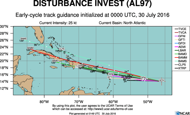
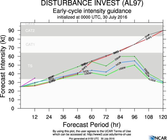
Model forecasts for the track of a tropical disturbance south of the Cape Verde Islands. Image provided by Tropical Tidbits.Model forecasts for the intensity of a tropical disturbance south of the Cape Verde Islands. Image provided by Tropical Tidbits.
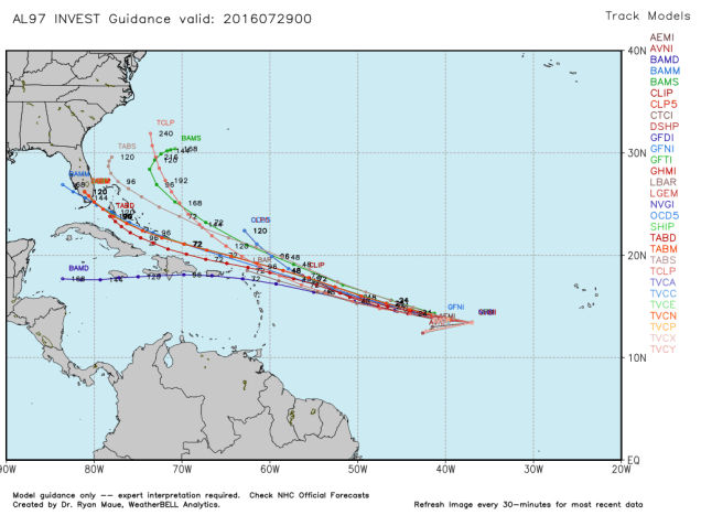
Meanwhile, farther to the west, another disturbance is about halfway between Africa and the Caribbean, and quickly heading westward this evening. The fast movement will likely preclude much development for now, but it should bring some gusty winds to the Lesser Antilles this weekend. Assuming it survives that long, we will need to keep an eye on it. As you can see below, many of the tropical models bring in just north of the Islands and into the Bahamas. There are other models that bring the system into the Caribbean and possibly the Gulf of Mexico well down the line. There are others that don’t expect the system to survive more than a few days.As the system gets closer to the Caribbean, we should start to get a better idea of what it might do and where it might go. Until then, it’s just something to keep an eye on.
Model forecasts for the track of a tropical disturbance in the Central Atlantic. Image provided by WeatherBell.Model forecasts for the intensity of a tropical disturbance in the Central Atlantic. Image provided by Tropical Tidbits.
We don’t know who first coined that phrase, but like most meteorological rules of thumb, it tends to hold true most of the time. Here in New England, especially Southern New England, we are definitely in a drought.
Latest update from the U.S. Drought Monitor.
A persistent pattern has led to warm and dry conditions across the Northeast for the past several months.While scattered showers and thunderstorms have produced locally heavy rainfall in some areas recently, widespread rainfall has been lacking. Many cold fronts have come across the region with little rainfall and coastal storms are rare in the summer to begin with. Even waves of low pressure passing south of New England along stalled out cold fronts have been too far south to produce much rain across our area.
Rainfall since the start of April has been well below normal across the region, especially in the Merrimack Valley. Image provided by the Northeast Regional Climate Center.
The dryness has been most noticeable since the beginning of June. Since June 1, Boston’s Logan Airport has recorded just 1.99″ of rain. This is the driest June/July on record in the city. The current record is 2.03″ from 1949. If Boston does not receive more than 0.04″ before Sunday night, a new record will be set (more on that later). In Worcester, the 3.18″ during the same timeframe is the 4th lowest total on record. In Lowell, 3.12″ of rain has been reported since June 1. This is the 8th lowest total on record.
So, is there any relief on the way? Maybe, though we wouldn’t count on it. A cold front will move across the region late Thursday and early Friday, then stall out south of New England. A wave of low pressure will ride along the wave, passing south of us on Friday. This wave will produce locally heavy rain and thunderstorms across the Ohio and Tennessee Valleys on Thursday, before it heads for the Mid-Atlantic states Thursday night. The question then is, how far north does the low and its associated rain shield get? This is the same situation we often see in the winter when trying to determine if a storm will miss us completely, bury us with heavy snow, or come too close and give us rain instead of snow. Thankfully, we don’t have to worry about snow for another 3-4 months at least.
Right now, there are several different solutions among the models, which have a rather large impact on the forecast.
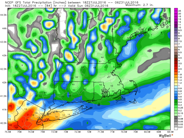
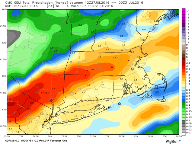
GFS model forecast for total rainfall through Saturday night. Image provided by WeatherBell.GEM (Canadian) model forecast for total rainfall through Saturday night. Image provided by WeatherBell.NAM model forecast for total rainfall through Saturday night. Image provided by WeatherBell.
For the past few months, as we’ve mentioned previously, most of these storms have passed too far south to have much of an impact on us. For this reason, we’re inclined to lean that way with the forecast for Friday as well. That means we’re going with the GFS model above. Is there a possibility that one of the other models is right and we do get heavy rain? Sure, they could very well be right, but we’re not betting on it.
Droughts feed on themselves, which is how the expression at the top of the page came into existence. When the ground is dry, there is even less moisture available for approaching systems. When there’s less moisture available, less rain falls. When less rain falls, the drought gets worse. So how do we break the drought? When we have one in the summer, usually, the answer is with a tropical system. Either a tropical storm/hurricane comes up the coast and slams into New England dumping copious amounts of rain on us, or one hits farther down the coast (North Carolina or the Gulf) and weakens inland and the remains of it move this way with heavy rainfall. The Summer of 1955 was hot and dry like this one has been. Then, in the span of a week in August, two Tropical Storms (Connie and Diane) brought record rainfall to the region, with widespread flooding. Of course, that’s not the scenario we prefer. A more gradual transition to a wetter pattern is the best case scenario, but that isn’t how is usually works.
So, right now, you’re probably asking “is there a tropical system heading our way?” No, there isn’t, not yet. Since our record-setting June, there hasn’t been any activity at all in the Atlantic in July, but that could be changing. A tropical wave moved off the coast of Africa on Tuesday, producing plenty of shower and thunderstorm activity. Although some of that activity diminished today, conditions are still favorable for some development over the next few days. The odds of the system becoming a tropical depression are still fairly low, and the odds of it impacting any land, let alone New England, are still fairly remote.
Model forecasts for the track of a tropical disturbance in the Eastern Atlantic. Image provided by the University of Wisconsin.Model forecasts for the intensity of a tropical disturbance in the Eastern Atlantic. Image provided by the University of Wisconsin.
Now that we’re approaching the beginning of August, these waves should start to move off the coast of Africa every few days. At least a few of these will eventually become tropical systems as we approach the peak of hurricane season, which is late August into late September. Another area to watch is down near the Bahamas. Sometimes tropical systems form in this region, and they can quickly strengthen and head up the coast within a couple of days, which is exactly what Hurricane Bob did in August of 1991.
For now, do your rain dance and pray for rain to save your garden or lawn. It doesn’t look like any beneficial rain is coming anytime soon (unless the NAM is right on Friday).
How many of you enjoyed the heat and humidity last week? You’re in luck! We’ve got more coming! How many of you enjoyed the severe weather last week? Guess what? There’s more of that coming too! Yup, it’s another summer week here in New England.
We start off with Monday, which will be hot and humid after a warm front crosses the region. As a cold front start to approach from the northwest later in the day, it will likely trigger thunderstorms across the region. Some of these storms could be strong to severe, so if you’re planning to be outside late in the day, keep an eye to the sky. The front moves through and then Tuesday is much drier, but still hot. High pressure keeps it hot on Wednesday too.Another front comes through on Thursday, with some additional showers and thunderstorms possible. After that, things get tricky. The front stalls out south of New England and a wave of low pressure rides along it, likely giving us some additional showers and thunderstorms on Friday. The big question is next weekend. Does another wave of low pressure ride along the front, giving is more showers along with cooler conditions, or does high pressure build in, pushing the front farther to the south? We’ll be optimistic for now, and go with high pressure building in, but keep in mind that this could change.
Forecast from the GFS model for dewpoints (colors) and lifted index (a measure of instability in the atmosphere) for 5pm Monday. Image provided by College of DuPage.
Monday: Becoming cloudy with showers and thunderstorms developing late in the day. Humid. High 88-95.
Monday night:Showers and thunderstorms taper off in the evening followed by clearing skies. Low 67-74.
Tuesday: Plenty of sunshine with a few clouds.Drier. High 88-95.
Tuesday night: Clear skies. Low 63-70.
Wednesday: Partly to mostly sunny. High 88-95.
Thursday: A mix of sun and clouds with a few showers and thunderstorms possible in the afternoon. High 90-97.
Friday: More clouds than sunshine with additional showers and thunderstorms, especially south of Boston. High 79-86.