
Now that we’re in August, the tropics are starting to get active all around the world. We’ll take a look at all of the systems out there, starting close to home.
A strong tropical wave is centered about 200 miles southeast of Kingston, Jamaica late this evening. The system is producing heavy rain and gusty winds across parts of the Dominican Republic, Haiti, and Jamaica, and these conditions will spread into the Cayman Islands on Tuesday. Although the system looks pretty good in satellite photos, it does not have a closed circulation as of yet. Once that occurs, the system will likely be upgraded to Tropical Storm Early.An Air Force Reserve Reconnaissance Aircraft will investigate the storm early on Tuesday to see if that has happened.


Whether or not the system develops, it should continue to move in a general westward direction at a fairly fast pace for the next few days. The system will likely move across the Yucatan or Belize towards midweek. After that, if it moves into the Bay of Campeche it could strengthen some more before hitting Mexico again late in the week. One thing that is likely is that heavy rainfall will lead to flash flooding and mudslides across pparts of the Dominican Republic, Haiti, and Jamaica through Tuesday, and parts of the Yucatan and Belize later this week. For the latter locations, rainfall totals of 8-15 inches are possible, which some heavier amounts not ruled out.
In the Eastern Pacific Ocean, Tropical Storm Howard is centered about 1125 miles west-southwest of Cabo San Lucas, Mexico late this evening. Howard has maximum sustained winds near 50 mph, and is moving towards the west-northwest at 14 mph. Howard is expected to continue moving toward the west-northwest or west over the next few days while steadily weakening as it moves over colder waters.
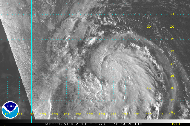
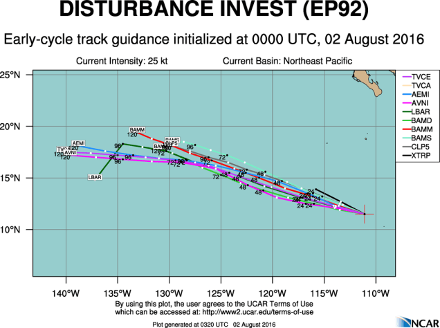
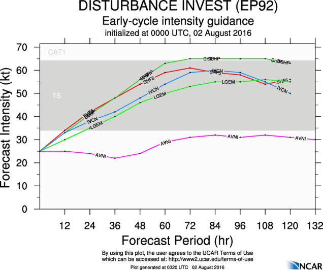
A little to east of Howard, a cluster of thunderstorms well southwest of Manzanillo, Mexico is being watched for development. Conditions look favorable for this system to develop over the next few days and it could become a tropical depression later this week. Forecast models show some steady strengthening through the week, and if the system gathers enough strength, it will be named Ivette.
In the Western Pacific Ocean, Typhoon 06W (Nida), made landfall very close to Hong Kong earlier on Tuesday. After lashing the northern Philippines with up to 10 inches of rain on Sunday, Nida took aim at Hong Kong on Monday. It made landfall in the pre-dawn hours of Tuesday just east of Hong Kong, producing a wind gust to 64 mph at Hong Kong International Airport, and a gust to 94 mph at Ngong Ping. Nida will continue to move inland on wednesday while dissipating. Rainfall totals of 6-12 inches are possible in the region, likely leading to flooding in some areas.

