Weekly Outlook: March 7-13, 2022

As you’d expect as we get into Spring, things will change quite a bit this week.

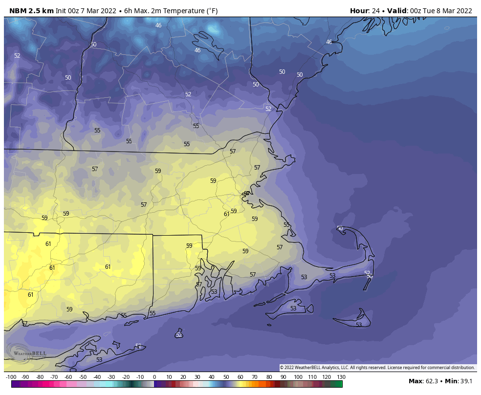
Low pressure will pass across New England today, bringing some rain in, mainly this afternoon and evening. With temperatures remaining mild, especially across Massachusetts, there’s even the potential for a rumble of thunder. The system pulls away tonight, setting up a sunny but breezy and cooler day on Tuesday. Another system passes by to the south on Wednesday, close enough for some clouds, but most of the precipitation with the system likely stays south of New England, though we could see a rain or snow shower reach the South Coast. By Thursday, we’ll start to turn milder once again as high pressure slides offshore, setting up the end of the week and the weekend.

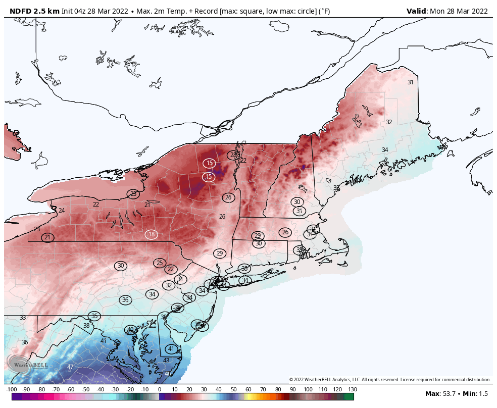
Another mild day is expected across the region. Image provided by WeatherBell.

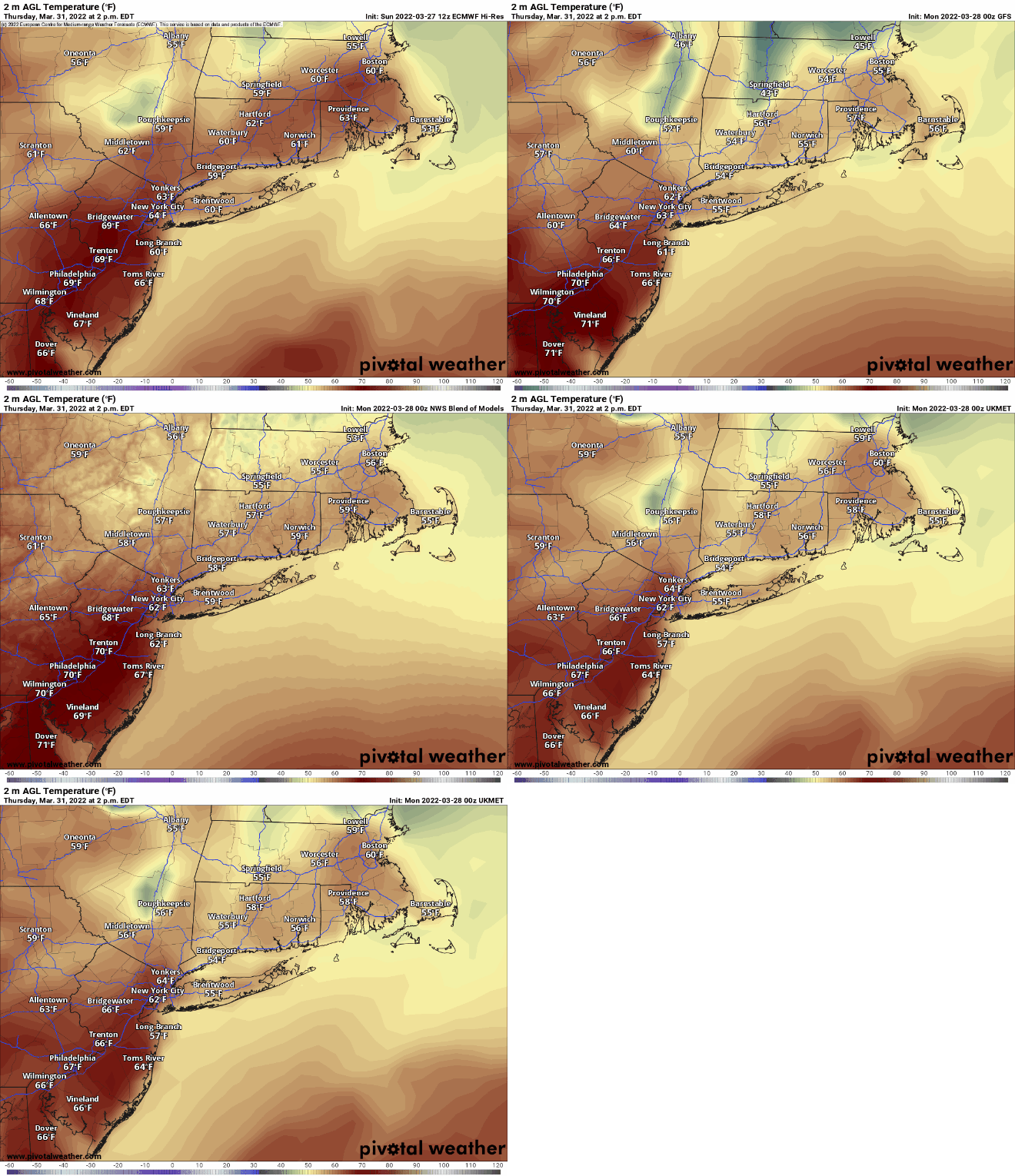
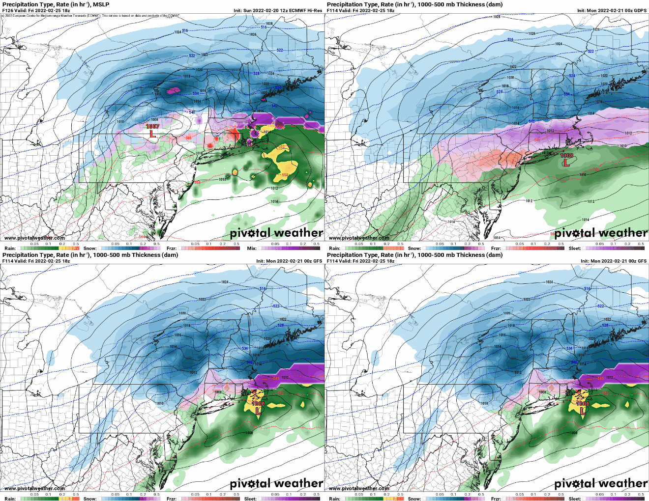
On Friday, low pressure will start to head up the Ohio Valley, crossing the Northeast on Saturday as it intensifies. We should be breezy and mild ahead of it, with rain likely Friday night into Saturday. Some of the models show the potential for very strong winds and potentially some heavy rain, but it’s still 5-6 days away, so for now it’s just potential. The system drags a cold front through later on Saturday, which may allow the rain to end as snow across the region, then windy and colder weather settles in for Sunday.

Most of the models show a rather potent storm system moving into the Northeast Saturday morning. Images provided by Pivotal Weather.

Monday: Cloudy and mild with periods of rain and showers during the afternoon. High 53-60, except 45-52 across southern New Hampshire.

Monday night: Rain during the evening, possibly a rumble of thunder, some clearing after midnight, breezy. Low 29-36.

Tuesday: Mostly sunny and breezy. High 39-46.

Tuesday night: Clear during the evening, clouds start to move in late at night. Low 20-27.

Wednesday: Plenty of clouds, just a slight chance for a rain or snow shower along the South Coast and Cape Cod. High 39-46.

Thursday: Partly sunny. High 46-53.

Friday: Morning sun, clouds move in during the afternoon, showers develop late at night. High 47-54.

Saturday: Cloudy and windy with rain likely, possibly mixing with wet snow before ending at night. High 53-60.

Sunday: A mix of sun and clouds., breezy, and colder. High 30-37.

Weekly Outlook: February 21-27, 2022

We’ve got a little bit of everything coming this week, unseasonably warm air (again), a snowstorm (again), some rain (again).

The week starts off with high pressure sliding offshore, allowing mild weather to return to the region today, with high temperatures likely topping 50 in many areas. Clouds start to stream in by late in the day though as low pressure heads toward the region. That low pressure system will pass north and west of the area later Tuesday, with gusty southwest winds bringing in very warm conditions in for Tuesday into Wednesday, with many places possibly topping 60 degrees on Wednesday. There are some indications that the warm air may struggle to move into southern and central New Hampshire on Tuesday, possibly holding off until Tuesday night, which may allow for a little freezing rain Tuesday evening. With the warm air comes some rain later Tuesday and Tuesday night, into early Wednesday morning. The rain ends when a strong cold front moves through, with skies clearing in the afternoon. High pressure builds in for Thursday with dry and cold conditions.

Wednesday could be a very mild day across the region. Image provided by WeatherBell

Another storm system moves into the Ohio Valley before redeveloping off the Mid-Atlantic coastline for Thursday night and Friday. There are still plenty of variables to be determined, but with colder air in place, we’ll likely see some snow to start. How much snow, and whether it changes over to sleet, freezing rain, and/or rain are questions that we cannot answer yet, but there is the chance for several inches of snow for at least part of the region. High pressure builds back in next weekend with dry and chilly conditions.

Thursday is looking wintry for at least part of the region for now. Images provided by Pivotal Weather.

Monday: Sunshine filtered through some high clouds at times. High 47-54.

Monday night: Increasing clouds. Low 26-33.

Tuesday: Some sunny breaks early, otherwise mostly cloudy and becoming breezy with showers developing in the afternoon. High 47-54, except possibly cooler across central and southern New Hampshire.

Tuesday night: Cloudy and windy with rain likely, possibly some freezing rain in parts of central or even southern New Hampshire for a while during the evening. Temperatures holding steady or rising overnight.

Wednesday: Lingering showers end early, clearing in the afternoon, breezy, and warm. High 58-65.

Thursday: Mostly cloudy and much colder, snow develops at night. High 31-38.

Friday: Breezy with snow likely, possibly mixing with or changing to sleet, freezing rain and plain rain, ending in the evening. High 30-37.

Saturday: Partly sunny and cold. High 25-32.

Sunday: Sunshine gives way to afternoon clouds. High 31-38.

Weekly Outlook: February 14-20, 2022

We’ve got quite the week coming up with everything from some snow and bitterly cold temperatures to heavy rain and possibly more record highs by the end of the week.

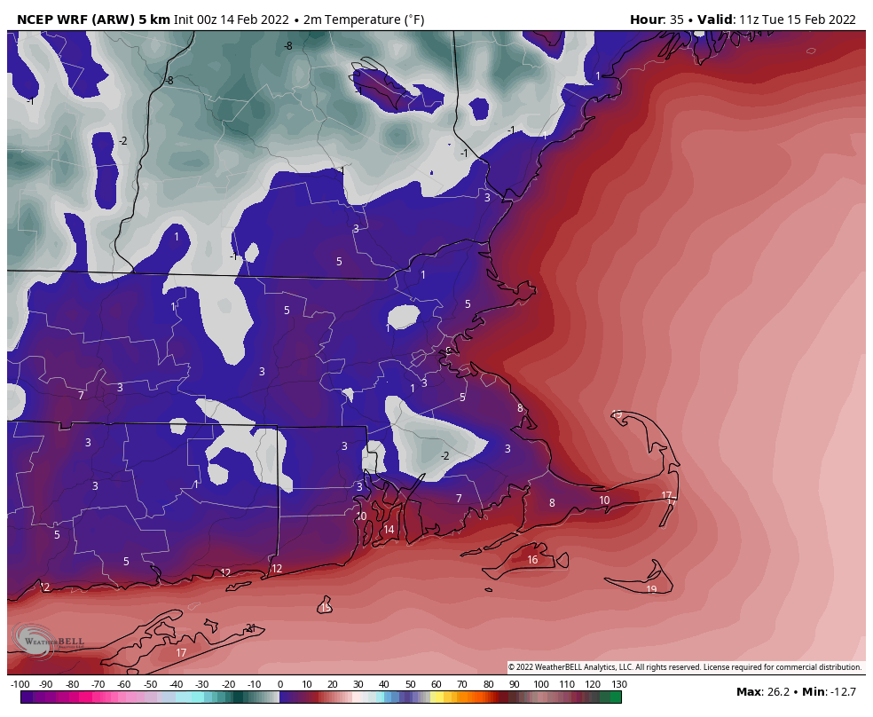
Snow showers will come to an end this morning, then skies will start to clear out this afternoon as high pressure starts to build in. Despite the developing sunshine, temperatures will only be in the 20s, which is 10-15 degrees below normal for mid-February. As skies become clear tonight and winds diminish, combined with the fresh snowcover, we’ll have some radiational cooling. Temperatures will likely drop into the single numbers, with some sub-zero readings possible. Tuesday remains chilly, but not quite as cold as today as the high pressure area continues to build in. By Wednesday, that high shifts offshore, and a significant temperature moderation develops. The milder air will be accompanied by clouds though as a storm system begins to move toward the region.

Tuesday morning looks quite chilly across the region. Image provided by WeatherBell.

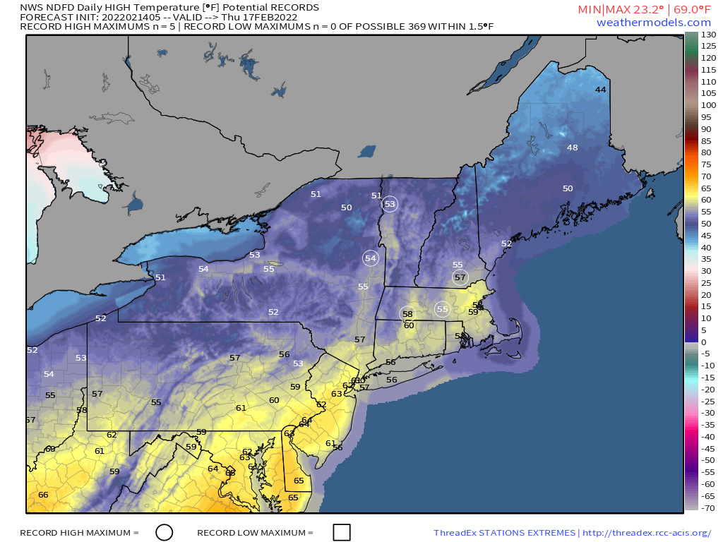
By Thursday, that system draws nearer, with gusty southwest winds sending temperatures well into the 50s and possibly 60s, with more record highs possible. While temperatures will be mild during the day, it looks like the warmest temperatures will be at night. We could be near or above 60 degrees at midnight Thursday night across the region. We’ll also have some heavy rain as the system gets closer, which combined with the mild weather, will help melt much of the snow that remains on the ground. A widespread soaking rainfall is likely, with rainfall totals of more than an inch possible. We wouldn’t even be surprised if there’s a rumble of thunder. This storm will likely produce some severe weather across the South, and while that’s not likely here, a few thunderstorms are possible. Friday likely starts off warm and wet with temperatures still in the 50s at daybreak, but as a strong cold front comes through during the morning, the rain will end, and temperatures will drop during the day. High pressure builds back in for the weekend with dry and seasonably cool conditions for Saturday, but we may start to turn milder again on Sunday.

Some record highs are possible on Thursday across the Northeast. Image provided by Weathermodels.com

Monday: Snow showers ending in the morning, skies start to clear out by late in the day, breezy. High 18-25.

Monday night: Becoming mostly clear. Low -2 to +5.

Tuesday: Sunshine and some afternoon clouds. High 23-30.

Tuesday night: Clear to partly cloudy. Low 6-13.

Wednesday: Sunny in the morning, clouds start to stream in during the afternoon, becoming breezy and milder. High 38-45.

Thursday: Plenty of clouds with some sunny breaks, especially in the morning, showers developing in the afternoon, becoming windy. Wind-swept rain likely at night, possibly some thunder as well. High 56-63. The warmest temperatures are likely at night.

Friday: Windy with rain ending in the morning, clearing during the afternoon. High 47-54 at daybreak, temperatures drop during the day.

Saturday: Mostly sunny. High 34-41.

Sunday: Sunshine and a few clouds. High 35-42.

Weekly Outlook: February 7-13, 2022

Much of the upcoming week will be dry and mild, but there are some exceptions.

A weak low pressure system will pass south and east of New England later today and tonight. It will spread some light rain into the area, though temperatures will be marginally cold enough for some light snow across the interior, mainly north and west of I-495. Rain ends late tonight, followed by gradual clearing on Tuesday. After that, we’ll have generally dry and mild weather through the remainder of the week, though some disturbances will spread in some clouds and possibly a few showers at times. We may turn colder again next weekend, but there are no big storms in sight.

Any snow today and tonight will be across the interior. Image provided by WeatherBell.

Monday: Cloudy with showers developing, mixed with snow across the interior. High 35-42.

Monday night: Cloudy with rain or snow showers gradually ending. Low 29-36.

Tuesday: Any lingering showers end early, skies start to clear out late in the day. High 38-45.

Tuesday night: Clear skies. Low 17-24.

Wednesday: Sunshine and a few afternoon clouds. High 35-42.

Thursday: Intervals of clouds and sunshine, slight chance for a shower. High 42-49.

Friday: Partly to mostly sunny. High 37-44.

Saturday: Partly sunny. High 42-49.

Sunday: More clouds than sun, much cooler. High 28-35.

Weekend Outlook: February 4-7, 2022

It’s mild today, but a messy Friday is on the way.

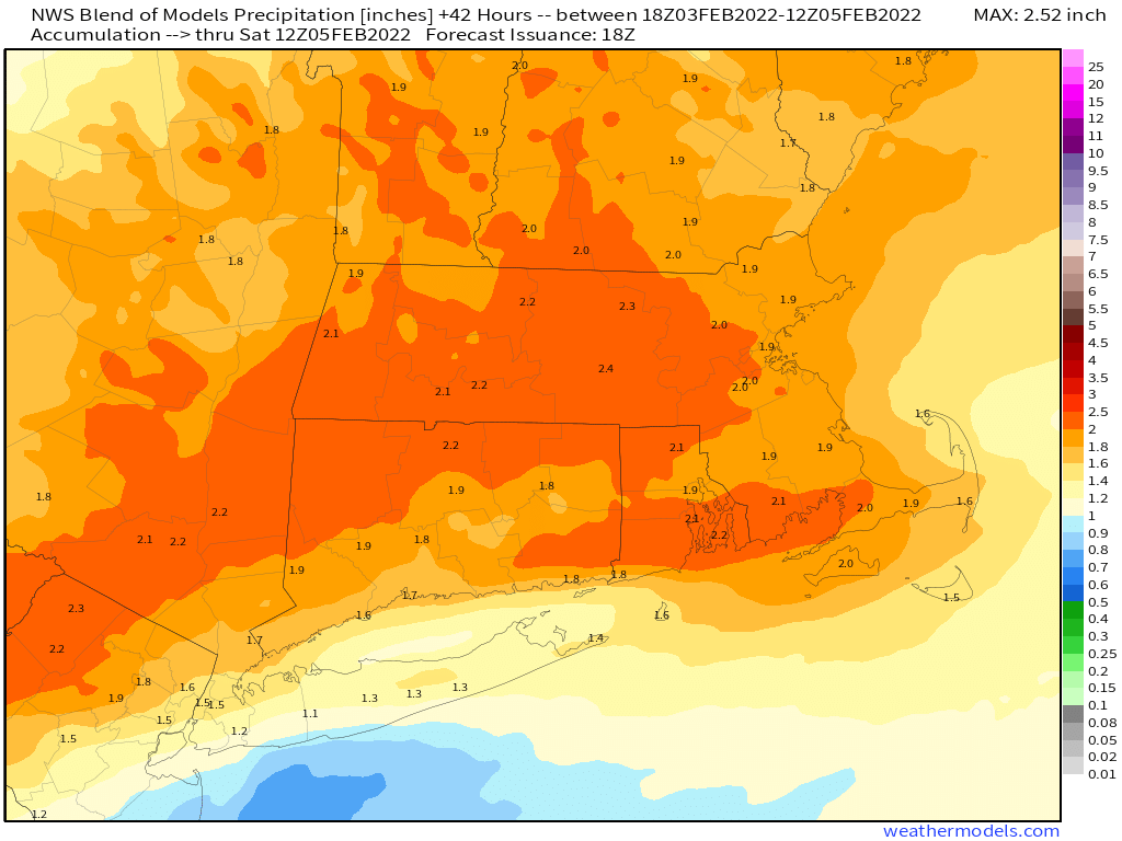
A strong cold is making its way toward the region this afternoon. We’ll have some rain ahead of it tonight, and the rain may be quite heavy. The combination of rain and mild temperatures will help to melt a lot of the snow that remains from last weekend’s blizzard. The front moves through this evening, and colder air will slowly make its way into the region early on Friday, first at the surface, then aloft. As temperatures drop, the rain will change to freezing rain and then sleet from north to south. With the roads already wet from the rain and temperatures dropping, a flash freeze is likely, and it will unfortunately be timed for the morning commute. If you’re going to be out in the morning, use plenty of caution, as untreated surfaces will become very icy quickly.

Much of the region will receive 1.5-2.0 inches of rain tonight and Friday. Image provided by Weathermodels.com

Temperatures will continue to drop during the day, with the freezing rain and sleet likely ending as some wet snow, mainly north of the Mass Pike. Everything winds down in the evening, then skies gradually clear out at night as high pressure builds in. This sets up a sunny but cold Saturday across the region. The high slides off to the east for Sunday and Monday, keeping us dry, but allowing temperatures to begin to moderate once again.

Saturday night looks quite chilly across the region. Image provided by WeatherBell.

Thursday night: Rain, possibly heavy at times, changing to freezing rain and sleet late at night, mainly across southern New Hampshire and northern Massachusetts. Low 26-33 north of the Mass Pike, 34-44 south of the Pike.

Friday: Rain and freezing rain changing to sleet, and eventually some wet snow north of the Mass Pike. Temperatures dropping during the day.

Friday night: Wintry mix ending, some clearing late at night. Low 12-19.

Saturday: Becoming mostly sunny, breezy, and cold. High 19-26.

Saturday night: Clear and cold. Low -7 to 0 north and west of Boston, 1-8 south of Boston.

Sunday: Sunshine and some afternoon clouds. High 24-31.

Sunday night: Partly cloudy. Low 9-16.

Monday: Partly sunny. High 34-41.

Weekly Outlook: January 31 – February 6, 2022

After a snowy weekend, quiet weather will settle in for a few days.

The week starts off on a rather chilly note with high pressure in control, but as it slides off to the east, temperatures will moderate for the next few days. By Wednesday, many locations could top 40 degrees. This will help to melt some of the mounds of snow across the region, but remember, with temperatures dropping below freezing at night, anything that melts will ice back up.

Wednesday could be relatively mild by early February standards. Image provided by WeatherBell.

The next storm system approaches on Thursday, and it looks a bit complicated. A cold front will bring colder air back into the region and a wave of low pressure will ride along it, possibly passing south of the region. With warmer air in place to start, we will likely see precipitation start as rain, but a change to sleet and/or freezing rain is possible, especially across the interior during Thursday night and Friday. We could see a change to snow before everything winds down Friday afternoon. We’ll obviously have a better handle on this storm later this week. High pressure then builds in for the weekend with cold and dry conditions.

Monday: Sunshine and a few clouds. High 24-31.

Monday night: Clear to partly cloudy. Low 4-11.

Tuesday: Partly sunny. High 30-37.

Tuesday night: Partly to mostly cloudy. Low 21-28.

Wednesday: Mostly cloudy. High 38-45.

Thursday: Cloudy with rain developing, changing to sleet and/or freezing rain across the interior. High 39-46.

Friday: Wintry mix possibly ending as snow. Temperatures dropping into the 20s and 30s during the day.

Saturday: Becoming partly to mostly sunny. High 18-25.

Sunday: A mix of sun and clouds. High 25-32.

Weekly Outlook: January 24-30, 2022

Another chilly week is expected, but trouble could be lurking next weekend.

A dry, but chilly day is expected today as high pressure builds in, but it won’t stay that way for long. An Alberta Clipper will be heading this way, sending clouds back in late today, with some snow showers late tonight into early Tuesday. Temperatures may be marginally warm enough to change the snow to rain across Cape Cod and the South Coast. Any accumulation should be an inch or less. Once that system moves by, high pressure builds back in for Wednesday and Thursday with much colder weather once again. Another weak system may bring in a few snow showers on Friday as temperatures moderate a bit. This brings us to next weekend.

Temperatures will remain below normal for most of the upcoming week, but the coldest air will stay to our north and west. Image provided by WeatherBell.

For several days now, the models have been indicating the potential for a significant storm system somewhere near the East Coast around Saturday, January 29. We’ve mentioned more times than we can count that the models aren’t trustworthy beyond about 2 or 3 days right now, but they have all had the same signal for quite some time, which gives us increased confidence that there will be some sort of storm, and it will probably be potent. However, models are showing little consistency beyond that in terms of how strong it will be, where it will track, what areas (if any) it might impact, and what impacts (if any) that it will have. At this point, everything is on the table, from a swing and a miss with the storm heading out to sea, to an inland runner, where we end up on the warm side with heavy rain and mild temperatures, to a mix of snow, sleet, freezing rain, and rain with the storm tracking right over us, to a full-fledged blizzard with the classic track right up the coast. Depending on which model you look at, and which run of that model, they have all indicated any and all of these scenarios at one point over the past several days. So, at this point, it is impossible to make a forecast, because frankly, we just don’t know, and probably won’t have a better idea of what to expect until at least mid-week. By the time we issue our Weekend Outlook on Thursday, we *should* have a decent idea of what will happen, but even that isn’t definite. So, stay tuned….

This is the last 5-days worth of forecasts from the GFS model that are all valid for this Saturday afternoon. Images provided by Tropical Tidbits.

Monday: Intervals of clouds and sun. High 27-34.

Monday night: Mostly cloudy with some snow showers possible. Low 18-25, temperatures may start to rise a bit after midnight.

Tuesday: Mostly cloudy with morning snow showers, possibly mixed with rain near the South Coast and Cape Cod, some afternoon sunny breaks develop. High 36-43.

Tuesday night: Becoming clear. Low 12-19.

Wednesday: Mostly sunny. High 19-26.

Thursday: Sunshine and some afternoon clouds. High 22-29.

Friday: Mostly cloudy with a chance for snow showers. High 32-39.

Saturday: Partly to mostly _____ with a chance of _____. High 26-33.

Sunday: Partly to mostly _____ with a chance of _____. High 24-31.

Weekly Outlook: January 17-23, 2022

The week is starting off on a very stormy note, but should quiet down later in the week.

A variety of advisories and warnings are in effect across the Northeast. Image provided by Pivotal Weather.

Low pressure will move across the region today, bringing a variety of hazardous conditions in, mainly during the morning hours. Some heavy rain is likely through the morning, tapering off by early afternoon as an occluded front moves across the region. Some strong winds are also likely this morning, especially near the coast, where gusts of 50-60 mph are possible. In addition, some coastal flooding is likely around high tide, due to the combination of strong onshore winds and already astronomically high tides. Notice what we didn’t mention? Snow. Any snow will be confined to areas well north and west of Boston, and likely will have changed to rain and/or ended by the time most of you read this.

Wind gusts could exceed 50 mph along the coast this morning. Image provided by WeatherBell.

During the afternoon it will still be breezy, but winds won’t be nearly as strong as they are in the morning. A cold front will move through by evening as the low passes by to our north, and that front could be accompanied by some rain or snow showers. High pressure then builds in for Tuesday with sunshine, but it will be breezy and turning colder once again. The cold air will be short-lived as another weak system approaches for Wednesday. As this system moves through, we could see some rain or snow showers late Wednesday and Wednesday night. High pressure then builds back in for Thursday and Friday, with a return to much colder weather, though not likely as cold as we had earlier this past weekend. As we head into next weekend, we’ll be keeping our eyes on a potential coastal storm. While some models have shown the potential for it to impact us next weekend, at this point, the more likely scenario is that it stays offshore with little impact, and high pressure continues to build in, keeping us dry and cold. As usual, we should have a better idea of what to expect when we publish our Weekend Outlook on Thursday.

Friday looks like it will be another very cold day across the region. Image provided by Weathermodels.com

Monday: Windy with snow across the interior changing to rain early, elsewhere rain, heavy at times in the morning, ending by early afternoon. Mostly cloudy with diminishing winds in the afternoon. High 41-48 in the morning, temperatures start to drop in the afternoon.

Monday night: Mostly cloudy and breezy, chance for a few rain or snow showers during the evening. Low 18-25.

Tuesday: Becoming partly to mostly sunny, still breezy. High 23-30.

Tuesday night: Clear during the evening, clouds start to move back in late at night. Low 8-15.

Wednesday: Mostly cloudy and breezy, chance for a few snow or rain showers late in the day and at night. High 37-44.

Thursday: Mostly cloudy, any lingering snow showers end early. High 31-38.

Friday: Partly sunny and cold, except mostly cloudy across Cape Cod with a few snow showers possible. High 17-24.

Saturday: Partly to mostly sunny. High 21-28.

Sunday: Mostly cloudy. High 28-35.

Weekly Outlook: January 10-16, 2022

Dig out the thermals and heavy winter gear, some really cold air is on the way.

Temperatures will turn colder today despite some sunshine, but this is just the opening act for what is on the way. An arctic cold front will cross the region this evening. It may produce some snow showers or squalls, so if you’ll be out this evening, be prepared for a short burst of snow that could significantly reduce visibility and drop a quick coating on the roads. Once the front moves offshore, bitterly cold air will flood into the region for Tuesday and Tuesday night. Temperatures will drop below zero in parts of the region Tuesday morning. Despite plenty of sunshine Tuesday afternoon, highs may struggle to reach the lower teens across most of the area, with wind chills that are below zero. Across Cape Cod, there may not be as much sunshine, as northwest winds blowing over the relatively mild water of Cape Cod Bay could produce some ocean-effect snow showers, especially across the Outer Cape. We’ll have another bitterly cold night Tuesday night, with subzero lows possible once again, but as high pressure slides off to the east on Wednesday, temperatures should start to moderate. It’ll still be chilly, but highs should get into the 30s across the area.

Wind chills could be well below zero Tuesday morning. Image provided by WeatherBell.

Temperatures will turn colder again for the end of the week, but there are bigger concerns. We’ve cautioned you recently that the models have performed rather poorly beyond 2 or 3 days, and that is still the case, so this part of the forecast is highly uncertain. However, many models are showing the potential for a powerful ocean storm to develop late Thursday into Friday, and a second storm to do the same over the weekend. The fact that they all show this gives us a little more confidence that they both may actually develop. The problem is, that’s about all they agree on. They don’t agree on the timing of the storms, the track they might take, how strong they’ll get, and what, if any, impacts they may have up here. These are things that we’ll be keeping a close eye on as the week goes by, but for now, what you read below is our “best guess” (for lack of a better term), but it is very low confidence.

The models all have different ideas about a potential coastal storm on Sunday. Images provided by Pivotal Weather.

Monday: Partly sunny. High 23-30.

Monday night: Partly cloudy and breezy, some snow showers or squalls are possible during the evening. Low -2 to 5 north and west of Boston, 6-13 south of Boston, wind chills could drop to -10 to -20 by daybreak.

Tuesday: Mostly sunny and very cold, except partly to mostly cloudy with some snow showers across parts of Cape Cod. High 8-15, with wind chills below zero.

Tuesday night: Partly cloudy. Low -2 to +5.

Wednesday: A mix of sun and clouds, breezy, and milder. High 31-38.

Thursday: Partly to mostly cloudy. High 35-42.

Friday: Mostly cloudy and breezy, chance for some light snow or snow showers, mainly across southeastern Massachusetts and Cape Cod. High 28-35.

Saturday: Partly to mostly sunny and cold. High 21-28.

Sunday: Plenty of clouds with a chance of snow, especially in eastern Massachusetts. High 28-35.

Weekly Outlook: January 3-9, 2022

A rather active pattern is expected to continue for this week, with some snow for parts of the region, possibly more than once.

The week starts off with low pressure passing south of the region today. It will be close enough to spread some light snow into the Cape and Islands, and possibly southeastern Massachusetts. Any accumulations will be confined to the Cape and Islands, with Nantucket and Martha’s Vineyard possibly seeing a few inches. For the rest of us, it’ll be a cloudy and chilly day. Many places won’t get out of the 20s, and wind chills will be in the teens, so keep that in mind if you’ll be outside for any length of time today. We’ll clear out tonight as the system pulls away, then high pressure builds in with sunshine and seasonably cool conditions on Tuesday. We’ll start to warm up again on Wednesday, but also will have plenty of clouds and some showers ahead of another cold front. That front moves through early on Thursday, bringing an end to the showers, and ushering cooler air back in. After that, things get very uncertain.

Most of the snow today will be confined to the Cape and Islands. Image provided by WeatherBell.

Some of the models have been hinting at the potential for coastal storm in the Thursday night/Friday time frame for quite some time now. However, since the models have downright awful beyond about 2-3 days, we haven’t bothered to look at the details too much, but have noted the potential. Well, it’s 5 days away now, and there is still plenty of disagreement as to what could happen, or if there will even be a system to affect the region. We’re of the belief that there will be a system, and it could produce some snow across at least inland locations. Beyond that, we’re not prepared to go into much more detail yet (though some of the usual internet trolls will probably be more than happy to find maps from models that show heavy snow and will share them all over Facebook and Twitter). Obviously, we’ll have a better idea as we get towards mid-week, and will elaborate more at that point, if needed.

Storm or no storm on Friday? It depends on which model you believe, if any of them. Images provided by Pivotal Weather.

High pressure builds in for Saturday with dry and chilly conditions, then another system could bring in some snow or rain showers for Sunday.

Monday: Plenty of clouds, snow showers likely across the Cape and Islands. High 25-32.

Monday night: Clearing and cold. Low 11-18.

Tuesday: Mostly sunny. High 29-36.

Tuesday night: Increasing clouds. Low 20-27.

Wednesday: Mostly cloudy, breezy, mild, chance for showers. High 45-52.

Thursday: Partly sunny. High 35-42.

Friday: Cloudy and breezy with a chance of snow or rain. High 32-39.

Saturday: Mostly sunny. High 26-33.

Sunday: Mostly cloudy with some snow or rain showers possible. High 37-44.