Weekly Outlook: June 17-23, 2019

If you picked this week for your vacation, then you’re probably not going to be happy, unless you’re heading out of town. This week looks quite damp. It’s not going to rain constantly, but most days will feature at least a chance of rain.

A cold front that moved through early this morning will stall out south of the region and remain there for much of the week. High pressure will build in today, allowing some sunshine and mild temperatures to move in, but clouds may linger along the south coast.

For Tuesday through Friday, waves of low pressure will ride along the front, bringing the clouds back in along with periods of showers and a few thunderstorms. None of the days will be a complete washout, but some showers are possible at almost any time. The best chance for some steadier and heavier rain looks to be during the day on Tuesday and again Thursday night into early Friday.
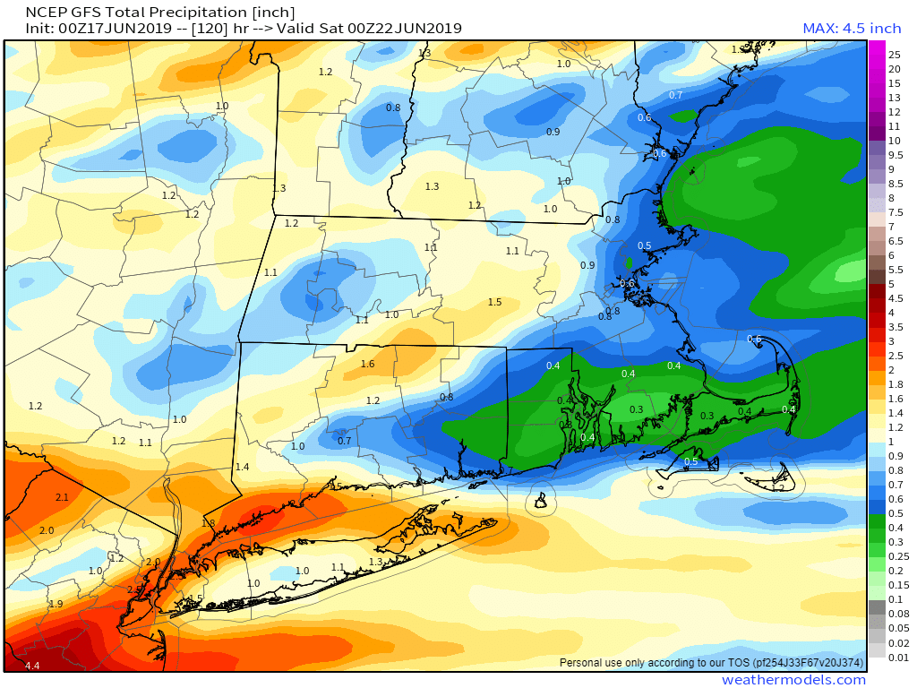
Some parts of the region could pick up an inch of more of rain this week. Image provided by Weathermodels.com

By late Friday, low pressure pulls away from the region and takes the frontal boundary with it. High pressure builds in, giving us a nice weekend, with sunshine and warm temperatures. As we head into next week, we may finally get a taste of summer warmth, though that is far from definite at this point. However, there is one model that it showing some very warm to hot weather moving in by early next week and remaining in place for much of the week. We’ll obviously get into more detail on that, if it materializes, in next week’s outlook.
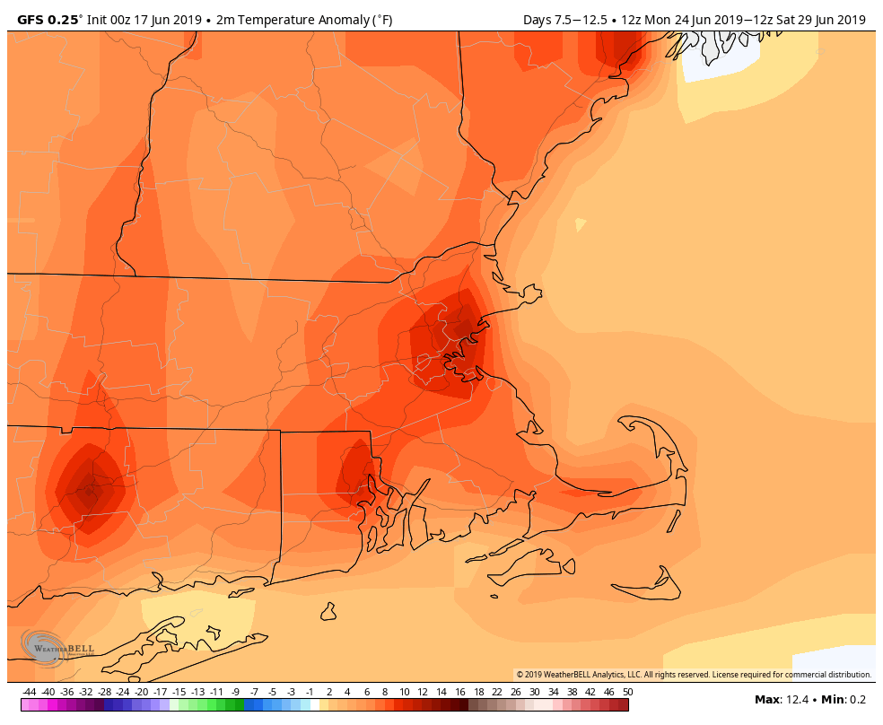
The GFS is indicating that temperatures next week could be 8-12 degrees above normal on average. High temperatures in late June should be near or just above 80, so you can do the math. Image provided by WeatherBell.

Monday: Partly to mostly sunny, but clouds may spread back in late in the day. High 74-81.

Monday night: Becoming mostly cloudy with a few showers possible late at night, mainly south of Boston. Low 54-61.

Tuesday: Cloudy with periods of rain and showers. High 68-75.

Tuesday night: Cloudy with a few showers, mainly during the evening. Low 54-61.

Wednesday: Clouds and a few sunny breaks, some showers and thunderstorms are possible. High 69-76.

Thursday: Mostly cloudy and breezy with periods of rain and showers likely, possibly heavy at night. High 72-79.

Friday: Mostly cloudy with more showers. High 68-75.

Saturday: Sunshine and some afternoon clouds, breezy at times. High 71-78.

Sunday: Plenty of sunshine. High 73-80.

Weekly Outlook: June 10-16, 2019

We just had an absolutely perfect weekend weather-wise, capped off by a convincing Bruins win to force a Game 7. Next weekend looks like it might be almost as good, but wouldn’t a parade make it better? Before we go there, let’s go through the week first.

After a fairly wet spring, we’ve actually been pretty dry over the past month. We’ll put a dent in that this week with 2 separate storms bringing in some rain.

We start the week off with high pressure sliding offshore, so the sunshine we’re starting the day off with will disappear behind clouds this afternoon. A warm front will move towards the region, bringing in some showers and maybe some thunderstorms tonight into Tuesday morning. The showers will end around midday as a cold front moves across the area. Some of the rain could be heavy, especially if thunderstorms develop. This is good news, as we’ve actually been a little dry lately, and need some rain to keep everything nice and green out there. Skies will clear out behind the front Tuesday afternoon and evening.

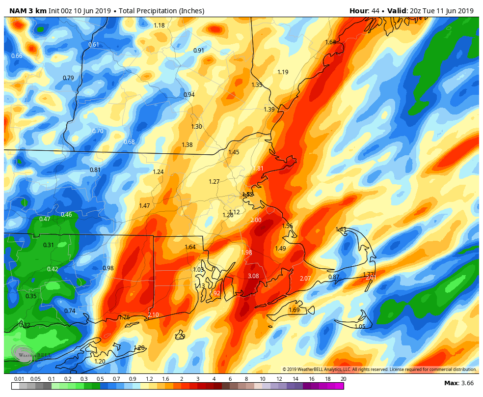
Some of the rain late tonight and early Tuesday could be heavy across the region. Thunderstorms could enhance the rainfall in spots. Image provided by WeatherBell.

High pressure builds in for Wednesday with sunshine and mild weather, but clouds will move back in late in the day ahead of another warm front. That night, while the Bruins are attempting to end the region’s torturous 129-day championship drought, showers will move in ahead of another warm front. Hopefully, the only Blues were talking about the next morning is from people depressed that it will be a cool damp day as low pressure moves across the region.

High pressure builds back in for Friday and Saturday with dry conditions once again. Friday may still be a little on the cool side, but Saturday should be warmer. Sunshine and warm temperatures are a great combination for a parade, right? They were in June of 2011. Another system will move towards the region on Sunday, with clouds and some showers moving in. There’s some question as to how quick they move in, so Sunday could end up being another dry or mostly dry day. We’ll have a better idea on that later in the week.

Monday: Sunshine to start the day, clouds move in during the afternoon. Showers are possible towards evening. High 73-80.

Monday night: Cloudy with showers likely, maybe a rumble of thunder. Low 57-64.

Tuesday: Showers and thunderstorms ending towards midday, then skies start to clear out during the afternoon, becoming breezy. High 71-78.

Tuesday night: Becoming mostly clear. Low 49-56.

Wednesday: Mostly sunny, clouds return at night. High 72-79.

Thursday: Periods of rain and showers likely, ending overnight. High 64-71.

Friday: Sunshine and a few afternoon clouds, breezy. High 68-75.

Saturday: Mostly sunny and breezy. High 72-79.

Sunday: Becoming mostly cloudy with a chance of showers, mainly late in the day. High 73-80.

Weekly Outlook: June 3-9, 2019

We’re into June, and that means that meteorological summer has started (which is why Satch was the appropriate music to start off this week’s update). We don’t have any heat and humidity on the horizon though. Let’s take a look at what we do have.

The week starts off with high pressure building in, giving us dry and mild weather for Monday. With clear skies, it’ll be a great night for star-gazing, with 5 visible planets as well. You’ll have Mercury and Mars in the evening, Jupiter and Saturday from before midnight until daybreak, and Venus rising about an hour before the sun. The International Space Station will also have a 4-minute pass overhead around 9:08pm. We’ll have sunshine to start the day Tuesday, but clouds will start to move in ahead of a slow-moving frontal system. We’ll have showers move in Tuesday night and into Wednesday as a warm front moves across the area. Most of Wednesday should be fairly dry, but a cold front will be approaching from the west. This may produce some showers Wednesday night, but more likely on Thursday when the front moves through in the afternoon.

Skies should be completely clear tonight, which should allow for some great star-gazing weather. Image provided by Weathermodels.com

Friday and into the weekend should feature dry and seasonably warm temperatures, but we’ll have to keep an eye on a couple of things. First, there will be an upper-level low in Atlantic Canada. It should be far enough east to have little impact on us, but if it sets up shop a little farther west, well, that could means clouds, cooler conditions, and maybe even a few showers along the coast as little pieces of energy rotate around the low. The other thing to keep an eye on its the front that moves through on Thursday will eventually stall out south of New England. Again, it should stall far enough to the south to not impact us, but if it stalls farther north than anticipated, then clouds and/or showers could impact south coastal areas. Again, both of these are low-probability right now, but the probability is not zero. We *should* have a good weekend weather-wise, but it’s not definite yet.

The cluster of thunderstorms in the Bay of Campeche is trying to organize itself into a Tropical Cyclone. If it does, it will be named Barry. Loop provided by NOAA.

Meanwhile, the start of meteorological summer also means the start of Hurricane Season in the Atlantic Basin, and we’ve already got something cooking in the Bay of Campeche. There’s a system down there that’s trying to get organized, but it doesn’t have a lot of time. It will head northwestward, towards northeastern Mexico or extreme southern Texas, likely moving inland late Tuesday or early Wednesday. Whether or not it develops, it will bring some heavy rain and gusty winds to that area over the next few days. We’ve already have Andrea this season, so the next system that gets a name will be called Barry.

Monday: Partly to mostly sunny and breezy. High 63-70.

Monday night: Clear skies. Low 43-50.

Tuesday: Morning sunshine, then clouds move in during the afternoon. Showers may develop towards evening. High 62-69.

Tuesday night: Cloudy with showers likely. Low 49-56.

Wednesday: Cloudy, showers taper off in the morning, then redevelop at night. High 71-78, cooler along the coast.

Thursday: Mostly cloudy with some showers and thunderstorms possible. Skies may clear out late in the day and at night. High 74-81.

Friday: Sunshine and some afternoon clouds. High 72-79.

Saturday: Mostly sunny. High 75-82.

Sunday: Partly to mostly sunny. High 71-78.

Weekly Outlook: May 27 – June 2, 2019

Today is Memorial Day, the “unofficial” start of summer. Unfortunately, the next few days won’t feel anything like summer around here. Some would say that’s just Spring in New England. We think it’s Mother Nature making the Bruins feel right at home as the Stanley Cup Final starts tonight.

The 1970 Cup Final rematch starts tonight. Here’s hoping it ends the same way the last one did – with a Bruins sweep. Image provided by Sportslogos.net

The week starts off a dry note as high pressure builds in behind a departing front. This will give us sunshine and mild temperatures. With light winds, a seabreeze will likely develop, keeping coastal locations several degrees cooler, as water temperatures are still only in the 50s. Late in the day, just before the puck drops for Game 1 at TD Garden, winds may shift back offshore, allowing warmer air to move back in to the coast.

Things go downhill for Tuesday and Wednesday. Remember that front that earlier? The one that went through last night? It’s going to stall out to the south. A wave of low pressure will ride along it on Tuesday, bringing us some rain and much cooler conditions. By Wednesday, some sunny breaks may develop, but some additional showers are also possible. That front will try to lift northward again as a warm front, but it may not get through until late Wednesday or Wednesday night.

Mid-afternoon temperatures in the middle to upper 40s? That’s what the models are showing for Tuesday afternoon. Image provided by WeatherBell.

Thursday should be a warmer and more humid day with the warm front to the north. However, a cold front will be approaching from the west, so we’ll have to watch out for showers and thunderstorms during the afternoon and evening hours. The front should be offshore by early Friday, allowing sunshine and mild temperatures to return.

At least one model is showing the potential for next Sunday to be a very warm day. Image provided by Weathermodels.com

Next weekend should start off with sunshine and seasonably mild temperatures as high pressure builds back in. Sunday is a bit uncertain at this time, as another frontal system could be approaching from the west. If it moves in fast enough, we could be looking at another round of showers and thunderstorms. If it’s a little slower, Sunday could be another dry and warm day.

Monday: Sunshine and some afternoon clouds. High 71-78, cooler right along the coast during the afternoon.

Monday night: Becoming partly to mostly cloudy. Low 46-53.

Tuesday: Cloudy and cool with periods of rain and showers developing. High 56-63 early, dropping into the upper 40s and lower 50s during the afternoon.

Tuesday night: Cloudy with showers likely in the evening, tapering off overnight. Low 45-52.

Wednesday: Plenty of clouds with a few sunny breaks. A shower or two possible during the day, more likely at night. High 60-67.

Thursday: More clouds than sun with a few lingering showers early. Showers and thunderstorms are possible again late in the day and at night. High 73-80.

Friday: A lingering shower or two early, then becoming partly to mostly sunny and breezy. High 71-78.

Saturday: Lots of sunshine.High 72-79.

Sunday: Partly sunny, chance for some afternoon showers or thunderstorms. High 71-78.

Weekly Outlook: May 20-27, 2019

The time has finally arrived. We hereby declare it safe to put away your snowbrushes, shovels, winter clothing, etc. Winter has finally ended around here. We hope you enjoyed the 3 days of Spring we had this year, because we’re going right to summer now.

There is a slight risk for severe weather across portions of northern and western New England today. Image provided by the Storm Prediction Center.

We get an early taste of summer today with warm and humid conditions. Many locations, especially away from the South Coast, could top 80 degrees this afternoon. However, with a cold front approaching this afternoon, we’ll have to contend with some showers and thunderstorms. Some of the storms could be quite strong to severe, especially north and west of Boston, up into southern New Hampshire and across central and western Massachusetts. Some of the stronger storms may produce torrential downpours, strong winds, hail, and frequent lightning.

Temperatures could get quite warm this afternoon with enough sunshine. Image provided by WeatherBell.

Once the front moves through, cooler and drier weather settles in for Tuesday on gusty winds. A pop-up shower or two can’t be ruled out as well. High pressure builds in for Wednesday with temperatures moderating back to seasonably mild levels.

The end of the week looks mild, but unsettled. We have a system moves through on Thursday, producing some showers across the region, mainly during the afternoon and at night. High pressure builds in with cooler and drier weather again for Friday and at least part of Saturday before another system approaches, with another round of showers likely later Saturday into Sunday. Neither of these systems look strong, and the timing is still a bit uncertain, so don’t go cancelling any outdoor plans for the weekend just yet. Yet another system may approach for Memorial Day, but for now at least, most of the day looks dry, with any shower activity likely holding off until evening or at night.

That large area of showers and thunderstorms east of the Bahamas and southwest of Bermuda could consolidate into a tropical or subtropical cyclone today or tomorrow. Loop provided by NOAA.

Meanwhile, in the Atlantic, the tropics look like they are starting to wake up a little. Hurricane season in the Atlantic officially starts on June 1, but it’s not unheard of for tropical systems to develop before then. As of early Monday morning, a disorganized area of showers and thunderstorms was located between the Bahamas and Bermuda. This area could become more organized over the next 12-24 hours, and could become a tropical or subtropical cyclone later today or Tuesday. While it is expected to remain weak, and should get absorbed by a cold front towards midweek, it could bring some showers and squally conditions to Bermuda. It’s not a threat to us here in New England, but it should serve as a reminder that hurricane season is nearly here and we are WAAAAAAAAAY overdue for a hurricane to impact us. The last one to make landfall in New England was Hurricane Bob in August of 1991.

Monday: Early clouds, maybe a few showers, then becoming partly sunny, breezy, warm, and humid with some showers and thunderstorms likely in the afternoon. High 78-85, cooler along the South Coast.

Monday night: Showers and thunderstorms end in the evening followed by clearing. Low 47-54.

Tuesday: Sunshine and some afternoon clouds, breezy, slight chance for a pop-up shower. High 61-68.

Tuesday night: Mostly clear. Low 43-50.

Wednesday: Partly to mostly sunny. High 62-69.

Thursday: Some sunny breaks early, otherwise mostly cloudy with showers likely late in the day and at night. High 65-72.

Friday: Becoming partly to mostly sunny. High 62-69.

Saturday: A mix of sun and clouds, chance for some showers during the evening and at night. High 67-74.

Sunday: Partly sunny, chance for a few showers. High 75-82.

Memorial Day: More clouds than sun, showers possible at night. High 71-78.

Weekly Outlook: May 13-19, 2019

We’ve been reminding you for a while now that it’s snowed around here into May before, and that was why we were reluctant to say that it was time to put away the shovels and snow brushes. Well, despite the fact that it’s mid-May, we’re still not there yet, as yesterday’s sleet should have reminded you.

Accumulating snow in mid-May? It’s happened around here before, back in 2002. Image provided by Tomer Burg.

We’ll start Monday off dry, but that won’t last long. A storm system will bring more precipitation in late in the day and into Tuesday. That precipitation will not be just rain for parts of the area. Sure, most of us will see rain, but some sleet and/or wet snow could be mixed in. Once you get into the hills, especially the Worcester Hills and the Monadnocks, there will almost certainly be some accumulating snow. Yes, it’s mid-May, and while this is rare, it’s not unheard of (see map above). The rain should come to an end on Tuesday, but with an upper-level low moving across the Northeast, we’ll remain cool on Wednesday with some more showers possible.

Several inches of snow may fall across the higher elevations of the Northeast over the next few days. More than a foot is possible in the White and Green Mountains and the Adirondacks. Image provided by Weathermodels.com

So, things start to get better on Thursday, right? We’re not that lucky. Another system comes along and brings in more rain for Thursday into Friday, then a cold front brings in even more showers on Saturday. Sunday is when we *should* finally see some improvement (we hope). While the rain may hang around that long, we should start to warm up for Friday and the weekend as an upper-level low pressure area moves out of the region. How warm we actually get is still to be determined, but we should at least be closer to normal, which is highs in the middle to upper 60s. Some models have it a little cooler than that, some a little warmer, some a lot warmer.

Average high temperatures for the middle of May are in the middle to upper 60s around here. We’ll be well below that for the first half of the week. That should change for the end of the week. Image provided by Weathermodels.com

Monday: Some sun in the morning, then becoming cloudy and breezy with rain developing late in the day. High 49-56.

Monday night: Rain, heavy at times, mixed with some sleet and/or wet snow at times, especially at higher elevations. Low 35-42.

Tuesday: Mostly cloudy, showers taper off in the morning. High 42-49.

Tuesday night: Partly to mostly cloudy. Low 34-41.

Wednesday: More clouds than sun, chance for a shower or two. High 52-59.

Thursday: A few sunny breaks early, otherwise mostly cloudy with some showers likely. High 59-66.

Friday: Partly to mostly cloudy with more showers possible, especially in the morning. High 60-67.

Saturday: Cloudy with some additional showers. High 62-69.

Sunday: A mix of sun and clouds. High 63-70.

Weekly Outlook: May 6-12, 2019

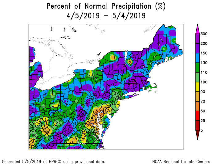
We’ve had quite a bit of rain over the past month, so we’re due for a break, right? Yes and no. We do have more rain on the way this week, but there might be a couple of nice days too.

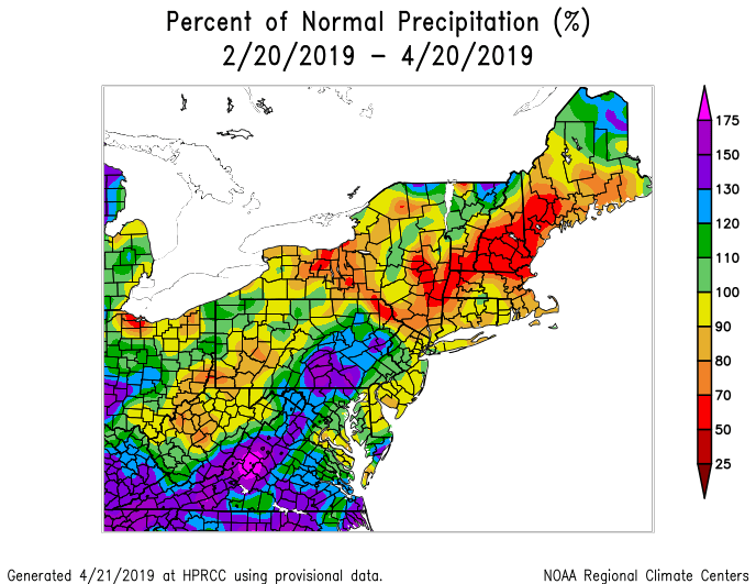
Precipitation has been well above normal across much of the Northeast over the past month. Image provided by the Northeast Regional Climate Center.

We’re starting Monday off with some clouds, and a few lingering showers across the Cape, but things will improve this afternoon as high pressure builds in. That big, bright thing that will appear in the sky this afternoon is called “the sun”. We haven’t seen much of it lately, but we will today. Oh don’t worry, it won’t hang around too long. Clouds come right back on Tuesday ahead of a cold front, with more showers in the afternoon, maybe even a thunderstorm. The difference between Tuesday and the recent rain? It’ll be warm ahead of the front. Instead of east to northeast winds off the chilly Atlantic, we’ll have warmer west to southwest winds. Temperatures could top 70 in many locations.

Tuesday looks like it could be mild before the cold front brings in more rain. Image provided by Weathermodels.com

That cold front will stall out south of New England, but probably just far enough offshore to allow for some clearing on Wednesday as high pressure tries to build in. Another storm will start to approach on Thursday, but with the front stalled out to the south, we’ll be chilly once again as more showers move in. Friday looks like a cool and wet day, though it could get warmer at least south of Boston as the front tries to move in. Everything moves offshore for the weekend, with drier weather returning, though we could see another system start to move in by late Sunday.

Monday: A cloudy start, but sunshine gradually develops from west to east. High 58-65, a little cooler along the coast.

Monday night: Becoming mostly clear. Low 39-46.

Tuesday: Sunshine in the morning, then clouds return. Showers, maybe a thunderstorm late afternoon, breezy at times. High 67-74, cooler along the South Coast.

Tuesday night: Showers, possibly a thunderstorm, during the evening, then skies clear out across much of the region overnight, though clouds may linger across the South Coast. Low 41-48.

Wednesday: A mix of sun and clouds, with cloudiness mostly likely along the South Coast, breezy. High 58-65.

Thursday: Some early sunshine, otherwise mostly cloudy with a few showers possible during the afternoon, more likely at night. High 50-57.

Friday: Cloudy with rain likely, ending at night. High 49-56, possibly warmer south of Boston.

Saturday: Becoming partly to mostly sunny and breezy. High 58-65.

Sunday: Becoming mostly cloudy. High 60-67.

Weekly Outlook: April 29-May 5, 2019

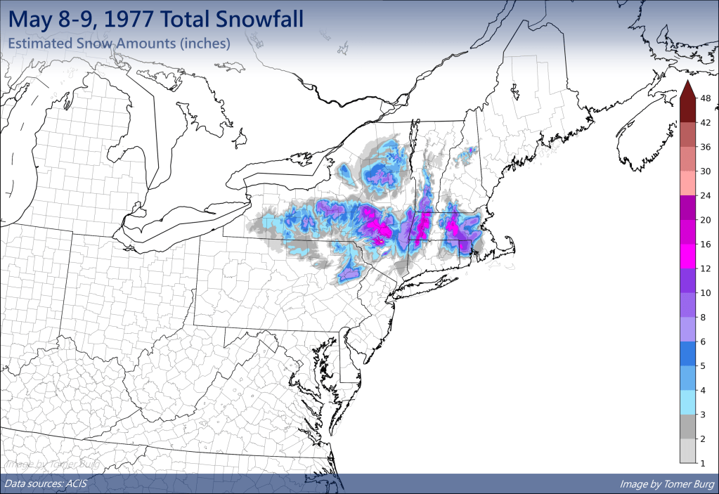
Can you believe that we’re at the end of April already? That means it’s almost to the time of year where it’s safe to push your snowbrush away! We’ve had accumulating snow into early/mid-May before, so it’s not quite that time yet, but we’re getting close.

We’ve had heavy snow into early May, so don’t put those snowbrushes away just yet. Image provided by Tomer Burg.

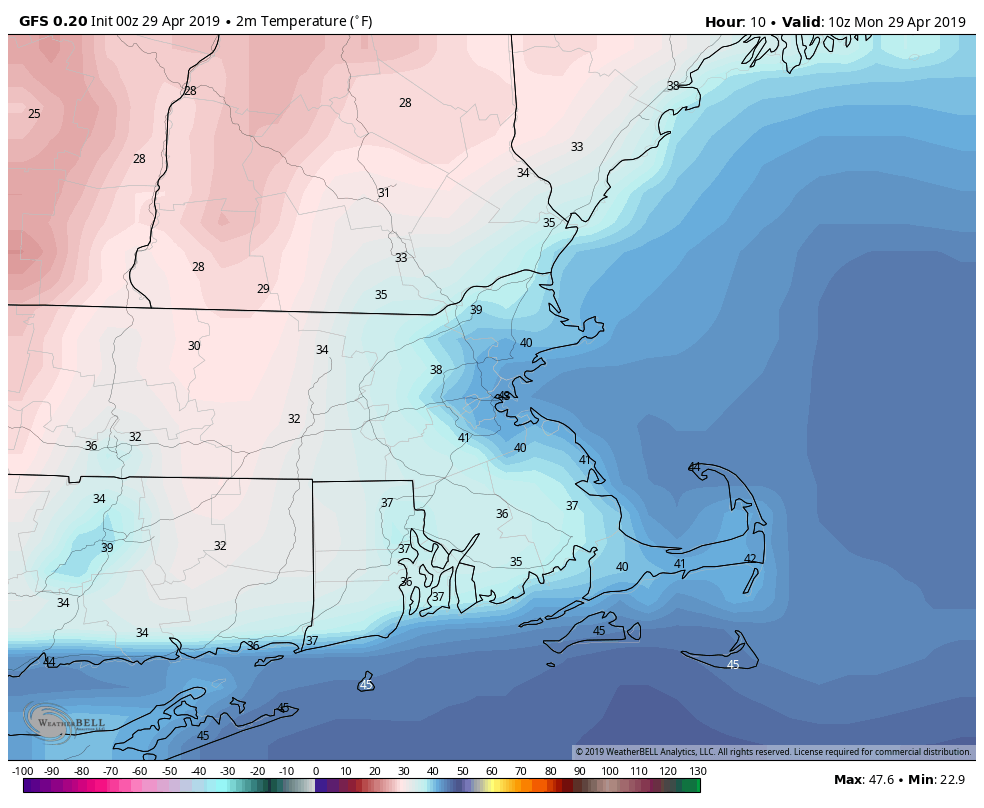
We’ll start the week on a chilly note as high pressure builds in from the north, so you may need a heavier jacket as you venture out Monday morning. You may even need to scrape your windshield if you’re out earlier enough, as there will likely be some patchy frost out there as well. Clouds will start to stream in during the afternoon as the high moves out and our next system approaches from the west.

Temperatures may drop into the 30s across much of the area before daybreak today. Image provided by WeatherBell.

Rain will develop late Monday night as a weak system moves toward the area. The rain won’t be heavy and should be done by early afternoon, with some clearing possible late in the day. A cold front trailing the system will stall out just south of New England, and then remain there for much of the week.

The latter half of the week looks to be cool and damp. Waves of low pressure will ride along that front, bringing in rainfall at times. We won’t be raining the entire time, but it will be mainly cloudy with some sunny breaks. With the front to our south, we’ll stay on the cool side around here, with daytime temperatures generally in the 50s to lower 60s., which is a little below normal for early May. Saturday may turn out to be a decent day with some sunshine and and milder temperature. However, a stronger storm will moves toward the area on Sunday, with some steadier and heavier rain more likely.

So close, yet so far away. Thursday afternoon could see temperatures get into the 80s in New York City, while we could be stuck in the 40s and lower 50s in the afternoon. Image provided by Weathermodels.com

Monday: Sunny and cool in the morning, clouds stream in during the afternoon. High 54-61.

Monday night: Cloudy with showers developing. Low 37-44.

Tuesday: Mostly cloudy with showers ending by midday. High 49-56.

Tuesday night: Partly to mostly cloudy. Low 34-41.

Wednesday: Plenty of clouds with a few sunny breaks. Showers are possible late in the day and at night. High 50-57.

Thursday: More clouds than sunshine with showers possible in the morning and some patchy drizzle in the afternoon. High 48-55, warmer as you head farther south and west

Friday: Cloudy with a chance for more showers. High 50-57, possibly warmer south of the Mass Pike.

Saturday: Partly sunny. High 66-73.

Sunday: Cloudy with a chance of rain, possibly heavy. High 53-60.

Weekly Outlook: April 22-28, 2019

Did you enjoy the sunshine and warm temperatures at the end of the past week? Good, because you probably won’t get much of that this week. This week looks rather wet at times. The whole week won’t be wet, but there will be a few days that are quite damp.

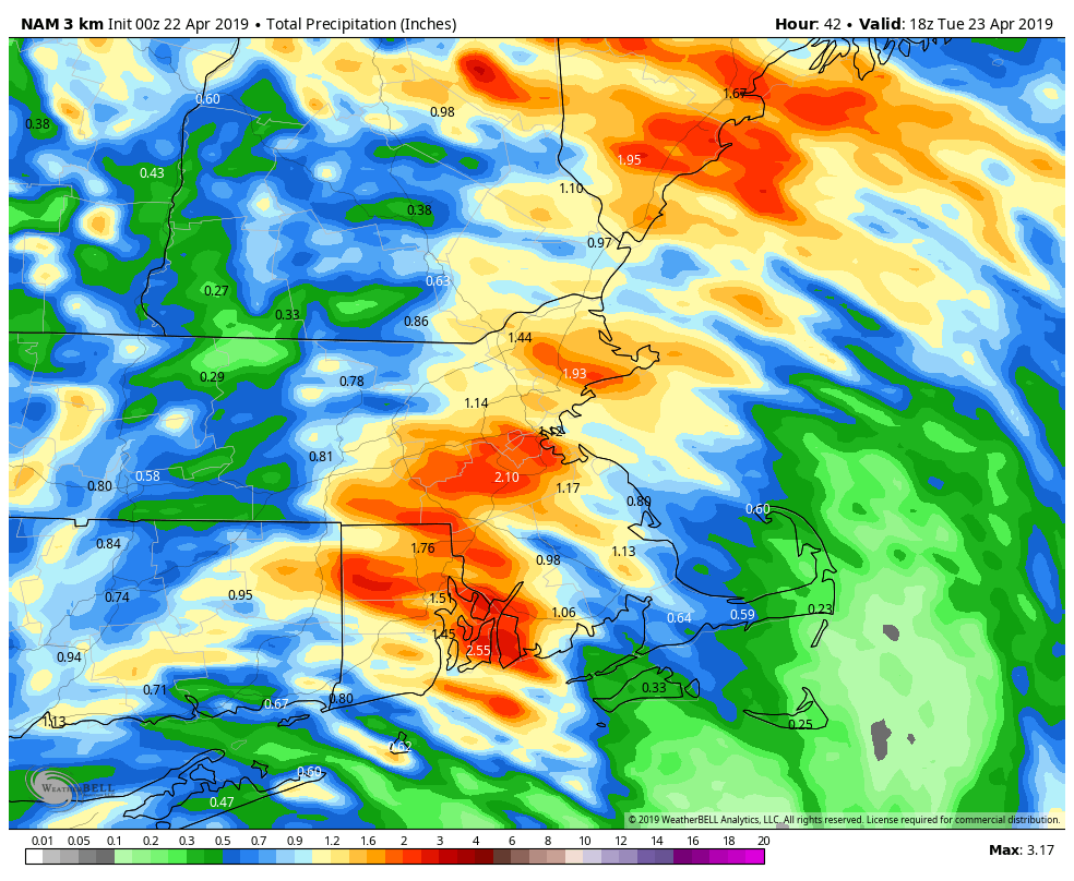
We start the week off with some fog this morning, especially along the south coast, since we have plenty of moisture in the air. A weak system will pass offshore today, and it will bring in a period of rain and showers, mainly across eastern New England. Some of this rain will be locally heavy, and thanks to northeast winds off the still-cool Atlantic, temperatures will be cooler than the past few days. The rain may linger into Tuesday morning before the system pulls away. Some sunny breaks may develop in the afternoon, but they won’t last long. Another cold front quickly approaches for Tuesday night into Wednesday morning with more showers.

Some of the rain today into early Tuesday could be heavy across eastern New England. Keep that umbrella handy. Image provided by WeatherBell.

High pressure builds in for later Wednesday into Thursday with sunshine and seasonable temperatures, but this too will only be temporary. The next system approaches on Friday, with, you guessed it, more rain, but it’ll be generally light. High pressure returns for Saturday with some sunshine, but again, not for long. Yet another system will move in for Sunday with another round of rain, and there’s a chance that this could be heavy too. We’ll keep an eye on that as the week goes along, but don;t go cancelling any plans for next weekend just yet.

Rainfall has actually well below normal over the last couple of months across much of the Northeast, so we really need this week’s rain. Image provided by the Northeast Regional Climate Center

Monday: Fog burns off early, then a few sunny breaks are possible before clouds return, with rain likely during the afternoon. Becoming breezy during the afternoon, especially along the coast. High 57-64, but turning cooler in the afternoon along the coast.

Monday night: Periods of rain and showers, possible heavy at times. Low 45-52.

Tuesday: A few lingering showers in the morning, otherwise cloudy with some sunny breaks in the afternoon. High 51-58, except 59-66 north and west of I-495.

Tuesday night: Cloudy with scattered showers. Low 41-48.

Wednesday: Showers ending early, then skies become partly to mostly sunny and breezy in the afternoon. High 60-67.

Thursday: Mostly sunny for much of the day, clouds start to filter back in during the afternoon. High 59-66.

Friday: Mostly cloudy with showers likely. High 54-61.

Saturday: Sunshine to start, clouds come back in the afternoon, breezy. High 54-61.

Sunday: Mostly cloudy with a chance of rain. High 55-62.

Weekly Outlook: April 15-21, 2019

We’ve reached Patriots Day, which is the “unofficial” end of winter in many years. We’ve got the Marathon, the Red Sox 11:05am game, and usually, but not always, some decent weather.

The morning may be quite wet, but things should improve for the Marathon and the Red Sox game. Loop provided by WeatherModels.com

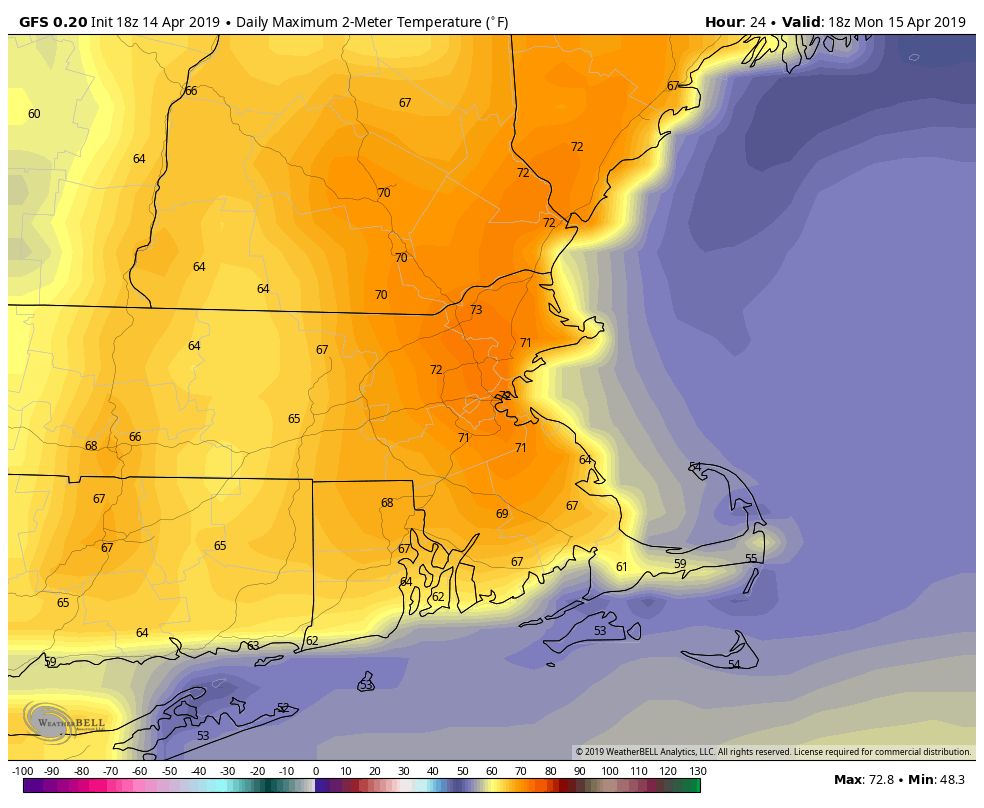
The week starts off on a damp but mild note as warm front lifts northward during the morning. Showers and maybe even some thunderstorms are likely. This system has been producing severe weather across much of the eastern half of the nation for the past few days, but we’re not expecting any severe weather here. Some downpours, gusty winds, and a little lightning are expected, but nothing severe. The rain should end around 9-10am, which is perfect timing for both the Marathon and the Red Sox game. Some sunny breaks could develop in the afternoon, which may allow temperatures to get up to 70 once again. The mild weather comes to an end late this afternoon as a cold front moves through, likely with a few more showers.

Temperatures could get close to or over 70 this afternoon if we can get some sunshine. Image provided by WeatherBell.

Windy and cooler weather moves in behind the front for Monday night into Tuesday as high pressure builds in. Wednesday looks dry as well, and slightly milder, but still cooler than what we enjoyed this past weekend. Thursday will see some clouds move in ahead of a warm front, along with some showers, but we’ll stay on the cool side until the front actually moves through, which will likely be sometime on Friday.

This brings us to the end of the week and the weekend. Another strong storm will be moving through the Plains states and into the Midwest. More severe weather is likely, but with this storm only making slow progress eastward, we’ll also be dealing with it for a couple of days. We’ll have some showers around on Friday as the milder air moves in, but a period of heavy rain is possible later Friday into Saturday. Don’t go cancelling any outdoor plans yet, but we’ve got the potential for quite a bit of rain. The rain may linger into Sunday before a cold front finally moves across the region.

Heavy rain is possible across the region on Saturday. Image provided by Pivotal Weather.

Monday: Rain, maybe a thunderstorm this morning, then some sunny breaks in the afternoon before another round of showers moves through late afternoon. High 64-71.

Monday night: Clearing, windy, and cooler. Low 34-41.

Tuesday: Sunshine and a few clouds, breezy. High 53-60.

Tuesday night: Clear skies. Low 33-40.

Wednesday: Mostly sunny, though some high clouds may start to stream in late in the day. High 54-61.

Thursday: Partly to mostly cloudy. High 48-55.

Friday: Mostly cloudy and breezy with a few showers possible, becoming a steadier rain at night. High 61-68.

Saturday: Cloudy and breezy with rain likely, possibly heavy. High 61-68.

Sunday: More clouds than sunshine, a few lingering showers possible. High 64-71.