A quick look at a map of the tropics shows that they remain active with four “named” storms out there. A deeper look shows that some of the storms aren’t as bad as they sound.

With the formation of Tropical Storm Beta in the western Gulf of Mexico, three “Tropical Storms” have formed on the same day in the Atlantic for the only the second time ever. Of course, the problem is, at least one of those storms should not have been named. In fact, it doesn’t even show up on the map above which shows the entire “tropical” Atlantic basin.
We’ll start with the most egregious system – Subtropical Storm Alpha. It formed just off the coast of Portugal this afternoon. It’s a cold-core storm, which means that it isn’t tropical. However, the National Hurricane Center claimed that it had acquired enough characteristics to become classified as “subtropical.” We claim that they’re padding the stats to break records, and we know that numerous other meteorologists think the same thing. As you can see on the satellite loop below, the center of the storm is already inland over Portugal. Monte Real Air Base along the coast of Portugal reported sustained winds of 36 mph with a gusts to 55 mph as the storm moved through. Winds only gusted to 20 mph or higher for 3 hours in that location. The storm will move into Spain and then dissipate in the next 12-24 hours.

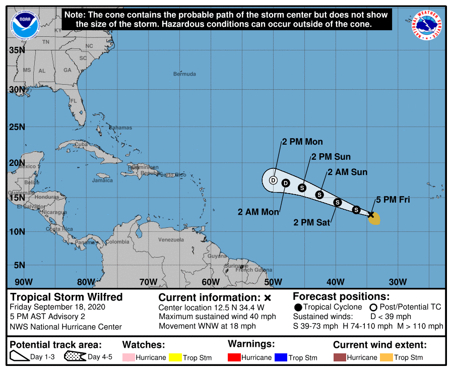
Next up is Tropical Storm Wilfred. Wilfred formed this morning over the central Atlantic. As of late Friday afternoon, it was centered about 735 miles west-southwest of the Cabo Verde Islands, moving toward the west-northwest at 18 mph. Maximum sustained winds were estimated to be near 40 mph. Most of the models aren’t bullish on the future of Wilfred, though the Hurricane Center thinks it may strengthen a little over the next 24 hours, but after that, conditions will be even less favorable for the system, and it will likely weaken. It will probably dissipate over open water late this weekend or early next week. It is not a threat to land.
In the western Gulf of Mexico, Tropical Depression 22 has become Tropical Storm Beta. As of late Friday afternoon, it was centered about 180 miles east-southeast of the Rio Grande, moving toward the north-northeast at 9 mph. Maximum sustained winds have increased to near 40 mph. There are no watches or warnings in effect for the coast of Mexico or Texas yet, but some will likely be issued tonight or early Saturday.
Beta is forecast to continue to strengthen over the weekend as wind shear decreases, and it could become a hurricane before the end of the weekend. As a ridge of high pressure builds in to the north, the storm should turn more towards the west, heading towards the Texas Coast. By late in the weekend, things get tricky. Another trough of low pressure will start to move into the nation’s midsection, turning Beta back towards the north and eventually northeast. The question is, when does that turn occur? Most of the models show it happening before the storm can get to the Texas coast, then it would likely parallel the coast, and possibly make landfall near the Texas/Louisiana border towards mid-week. This is the same area that was just devastated by Hurricane Laura a few weeks ago. Of course, a later turn would allow it to make landfall along the southern or south-central Texas coast, then head across inland portions of coastal Texas in a weakened state. Either way, very heavy rain is likely across parts of the southeastern Texas and into western Louisiana over the next 5-7 days.

Finally, we get to the strongest storm of the bunch – Hurricane Teddy. As of late Friday afternoon, Teddy was centered about 800 miles southeast of Bermuda, moving toward the northwest at 14 mph. Maximum sustained winds have decreased to near 125 mph. Teddy will remain a formidable storm through the weekend, but some gradual weakening is expected. A turn more toward the north is likely, which should keep Teddy about 100-150 miles east of Bermuda late this weekend. A Tropical Storm Watch has been issued for Bermuda as a precaution, but the most significant weather with the storm will stay well to the east.

Once it is past Bermuda, Teddy will continue northward while weakening, but it also will start to transition into an extratropical storm. Although it will likely no longer be tropical, it will still bring strong winds and heavy rain to parts of Nova Scotia and Prince Edward Island when it moves across these areas Tuesday into Wednesday. Wind gusts of up to 80 mph are possible along the Atlantic coast of Nova Scotia, with gusts to 40-60 mph across the remainder of the region. Rainfall totals of 2-5 inches may result in some localized flooding.

Elsewhere, there are two other areas of note in the Atlantic. The first one is the extratropical remains of former Hurricane Paulette. This system will drift southward west of the Azores over the next few days, and as it moves over some warmer water, it could reacquire some tropical characteristics. There is also another tropical wave that will roll off the west coast of Africa on Saturday. Conditions may be favorable for some slow development as it makes its way across the Atlantic over the next week or so.
