The late great Dick Albert loved to used abbreviations on his forecasts maps, and we’re going to invoke one of his more common ones for this week’s forecast – MOTS (More Of The Same).
Stop us if you heard this before – we’ll start the week with high pressure in control, providing us with ideal cookout weather for Labor Day – sunshine, warm temperatures, and moderate humidity. As the high slides off to the east, temperatures and humidity levels will creep up a bit for Tuesday and Wednesday.

We’ll have a cold front move across the region on Thursday, bringing us some showers and thunderstorms, but right now they don’t look that heavy, so the drought we’re in will likely continue to worsen. High pressure builds in behind that front with cooler and drier conditions for Friday and Saturday. Sunday doesn’t look as good, with clouds and some showers possible, but given the recent performance by the models beyond a few days, we’re skeptical as to how wet it will be. We should have a better idea by the time we get to our Weekend Outlook on Thursday.

Monday: Sunshine and plenty of it. High 75-82.
Monday night: Clear to partly cloudy. Low 57-64.
Tuesday: Partly to mostly sunny. High 80-87.
Tuesday night: Partly cloudy. Low 59-66.
Wednesday: A mix of sun and clouds. High 80-87.
Thursday: More clouds than sun with some showers or thunderstorms possible. High 79-86.
Friday: Becoming partly to mostly sunny and much cooler. High 68-75.
Saturday: A mix of sun and clouds. High 67-74.
Sunday: Mostly cloudy with a chance of showers. High 71-78.
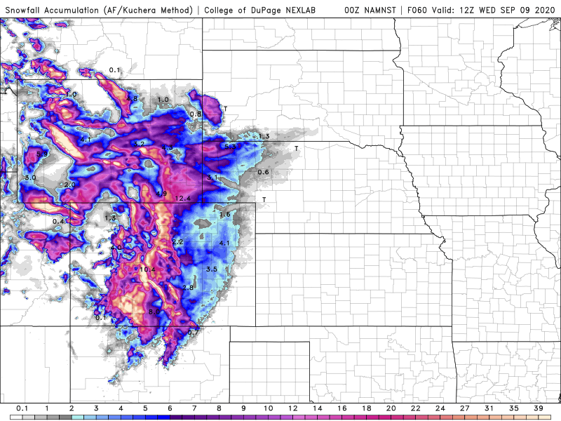
On a separate note, while our weather has been, and will continue to be fairly quiet, there is some wild weather going on in other parts of the nation. Much of California and the Southwest has been baking in some extreme heat over the weekend. San Francisco set a record high when it reached 100 downtown yesterday and 102 at the airport. The normal high for the day is only 74. Even wilder weather will invade the Rockies and the Plains in the coming days. Denver reached 97 yesterday, tying their record for the day. They should reach 90 again on Monday ahead of a strong cold front. Behind that front, they could receive 6 or more inches of snow on Tuesday. Denver’s record for earliest snow on record is September 3, 1961. On average, they don’t see snow until October 18. In the higher elevations of the Rockies, snowfall totals 1-2 feet or more are possible.
We also have a new tropical depression in the Atlantic. Tropical Depression 17 developed last evening. It will likely become Tropical Storm Paulette today, but will remain over open water for the next several days, presenting no threat to land. Another wave in the eastern Atlantic could become a tropical depression or storm in the next day or two as well. The climatological peak of hurricane season is still about 10-14 days away, so the uptick in activity is not a surprise at all.
