We’re in a typical summertime pattern for a few days, but more rain is on the way.
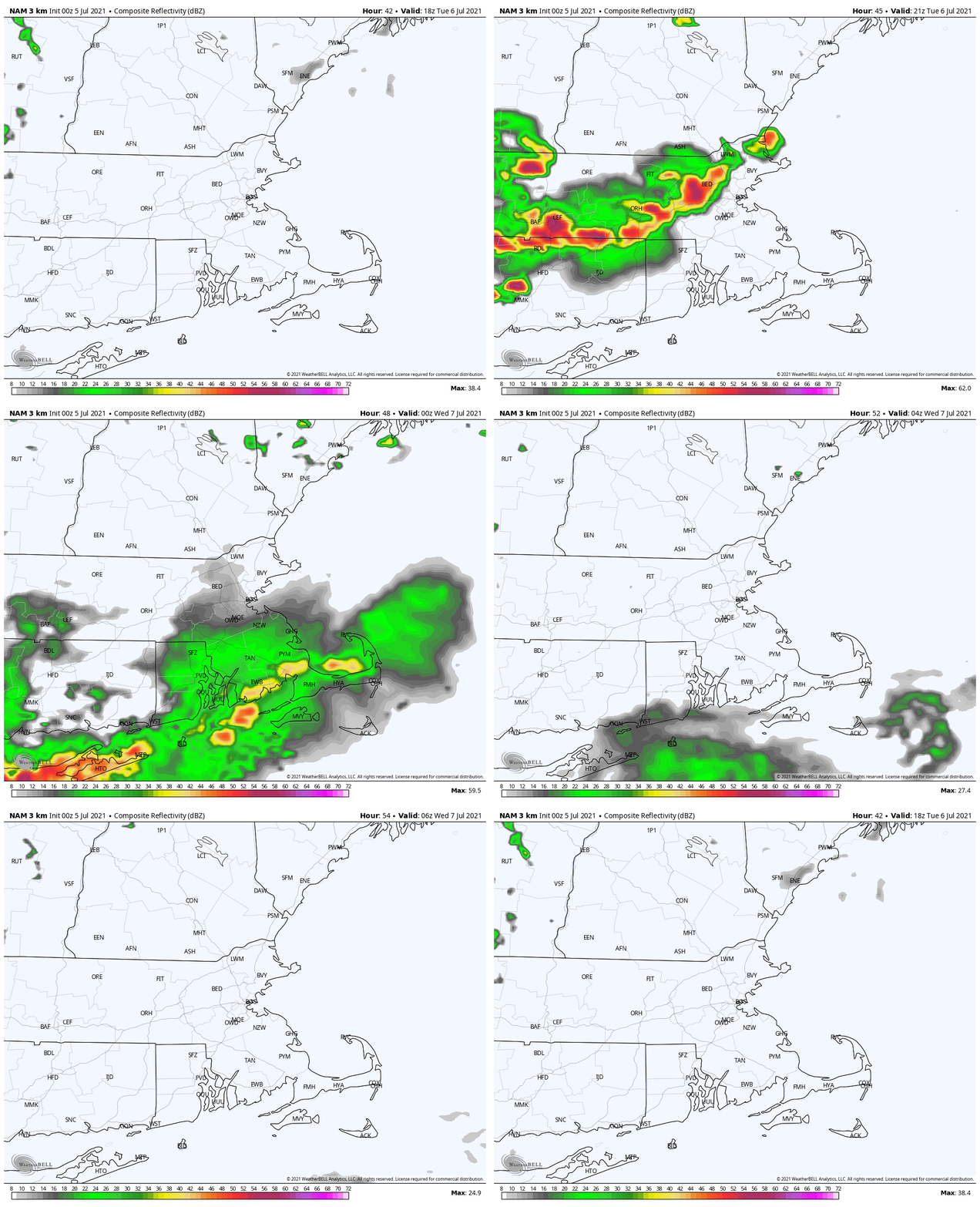
High pressure is sitting offshore, which means another hot and humid day is expected on Friday, with temperatures well into the 80s and lower 90s in most locations. A few late-day showers and thunderstorms are possible, but activity shouldn’t be that widespread. An approaching frontal system will spread more clouds in for Saturday, keeping temperatures down a bit, with a better chance for more widespread showers and thunderstorms, especially late Saturday and Saturday night. Some of these storms may produce heavy rain, because that’s what seems to happen with every storm this month. That front will stall out near or just south of the region for Sunday and Monday. That means it’ll be cooler with more cloud cover and a chance for more showers and thunderstorms, though areas near the South Coast could remain warmer, depending on where the front actually stalls out.
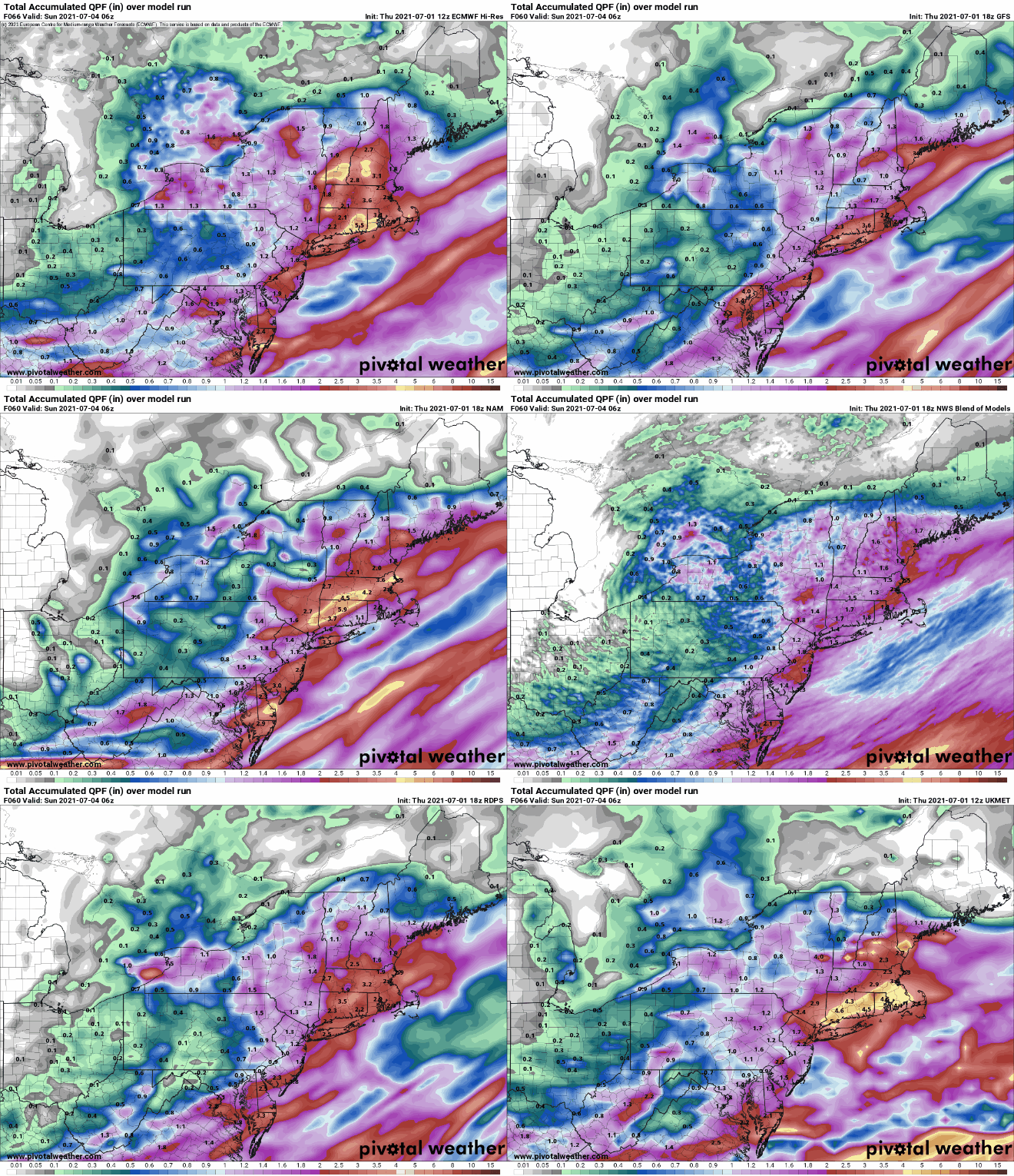
Some heavy rain is possible across parts of the region this weekend. Images provided by Pivotal Weather.
Thursday night: Partly cloudy. Low 65-72.
Friday: A mix of sun and clouds, chance for some late-day showers and thunderstorms. High 85-92.
Friday night: Partly to mostly cloudy, any showers end in the evening. Low 64-71.
Saturday: Plenty of clouds, showers and thunderstorms are likely in the afternoon. High 79-86.
Saturday night: Cloudy with scattered showers and thunderstorms, some of which may produce heavy rain. Low 63-70.
Sunday: Mostly cloudy and cooler with a few showers and thunderstorms possible. High 72-79.
Sunday night: Mostly cloudy. Low 61-68.
Monday: More clouds than sun with a shower or thunderstorm possible. High 74-81.
We’ve got showers and thunderstorms in the forecast for nearly every day this week, but aside from today, it may not actually be that wet in most spots.
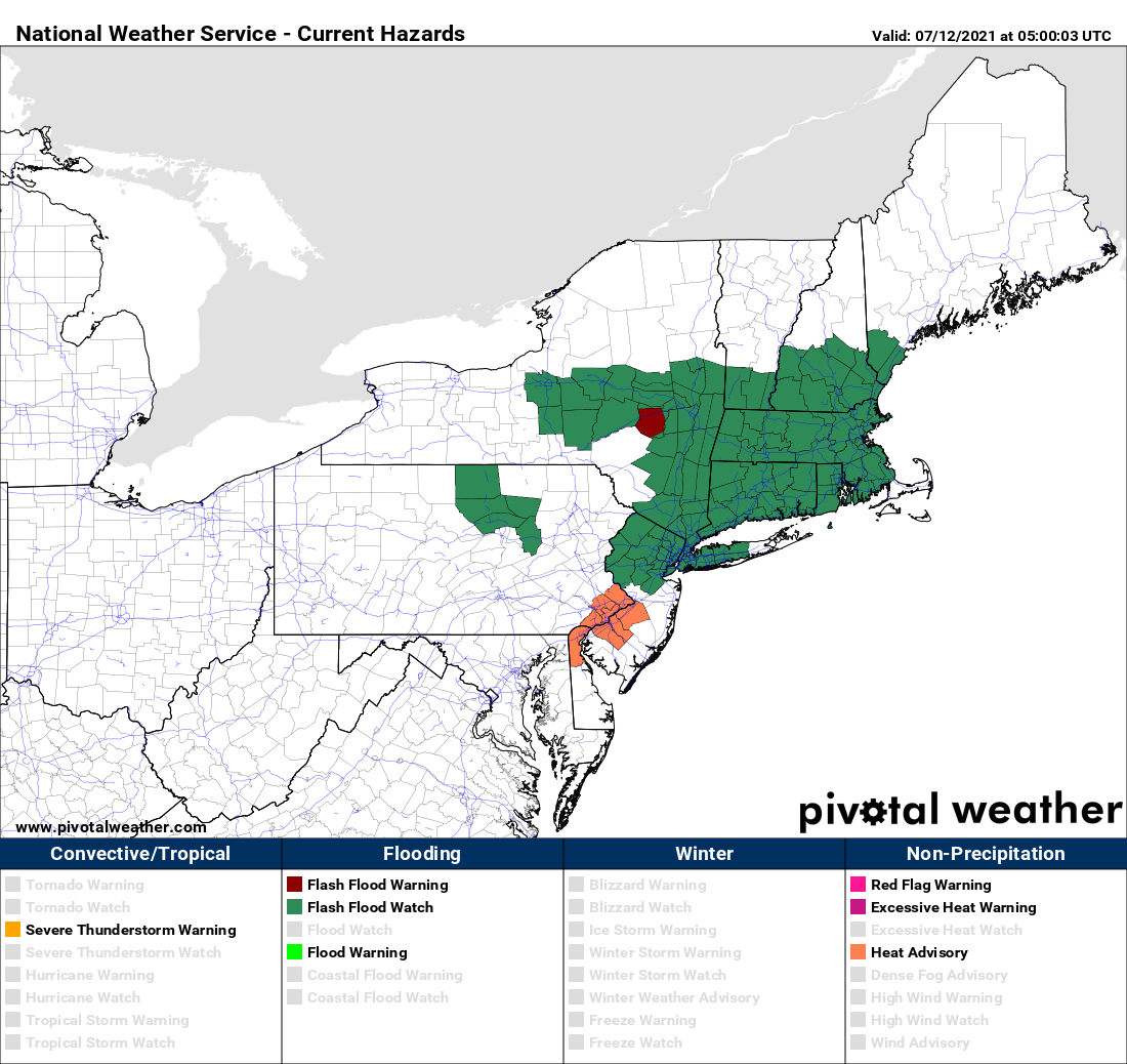
Flash Flood Watches are in effect for much of the region. Image provided by Pivotal Weather.
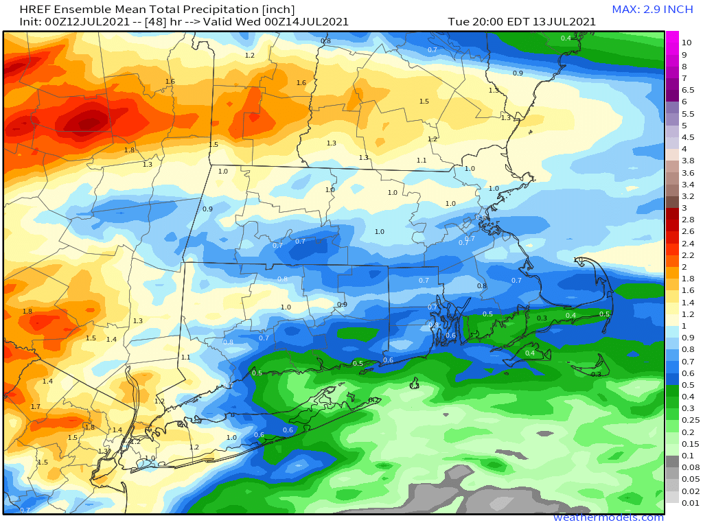
A warm front is going to take its time crossing the region today and Tuesday. A wave of low pressure riding along the front will bring in rain today, some of which may be heavy. Given the amount of rain we’ve had over the past 2 weeks, the ground is already saturated in many areas, so additional rain will lead to flooding problems. As a result, flash flood watches have been issued for much of the region. Tuesday looks to be drier, but still on the cool side, as the front will take its time lifting northward. A few showers can’t be ruled out.
Some locally heavy rainfall is possibly today, especially north of the Mass Pike. Image provided by Weathermodels.com
The front finally lifts through on Wednesday, allowing warm to hot and humid weather to return, and it will remain in place into Saturday. With the hot and humid weather will come a daily chance for showers and thunderstorms. Those showers and storms will become more numerous on Sunday as a cold front moves in.
Saturday looks to be the hottest day across the region. Image provided by WeatherBell.
Monday: Plenty of clouds with periods of rain and showers, mainly during the morning. High 67-74.
Monday night: Mostly cloudy with a few showers possible. Low 58-65.
Tuesday: Clouds and a few sunny breaks, chance for a shower or two. High 68-75.
Tuesday night: Partly to mostly cloudy. Low 59-66.
Wednesday: More clouds than sun with scattered showers and thunderstorms possible. High 76-83.
Thursday: A mix of sun and clouds, chance for a late-day shower or thunderstorm. High 79-86.
Friday: Partly sunny, a shower or thunderstorm may pop up. High 82-89.
Saturday: A mix of sun and clouds, breezy, showers and thunderstorms possible late in the day and at night. High 82-89.
Sunday: Partly to mostly cloudy with scattered showers and thunderstorms. High 78-85.
We’re not sure if you’ve heard, but Tropical Storm Elsa is heading this way. It have have some impacts around here tonight and Friday.
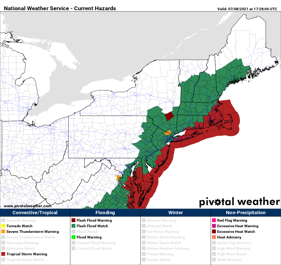
Flash Flood Watches are in effect for much of the Northeast, with Tropical Storm Warnings along the coast. Image provided by Pivotal Weather.
As of 2pm EDT, Elsa was centered about 25 miles southwest of Raleigh, NC and moving toward the northeast at 20 mph. Maximum sustained winds are down to 45 mph. A Tropical Storm Warning is in effect for the coast of Connecticut from New Haven eastward, coastal Rhode Island, and nearly all of the coast of Massachusetts from the Mouth of the Merrimack River southward (sorry Salisbury, you don’t get to play), including Cape Cod and the Islands. Elsa will continue northeastward tonight, turning more toward the east-northeast on Friday, likely passing right across southeastern Massachusetts.
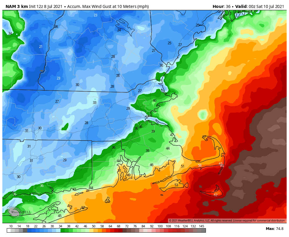
Winds may gust to 40 mph or more across parts of RI and southeastern MA on Friday. Image provided by WeatherBell.
Tropical systems have different characteristics when they get up this way, compared to how they look in the Caribbean or Gulf of Mexico. They take on a “rain to the left, wind to the right” appearance. This means that the heavy rain shifts to the left side of the storms track, while most of the strong winds are to the right of the track. In this case, that means most of the wind will be confined to parts of southern RI, southeastern MA, and the offshore waters, but much of the rest of the region can expect heavy rain. How much rain? Rainfall totals of 2-4 inches and possibly heavier, most of it falling between about 8am and 2pm on Friday. Oh, an just to add to the fun for the folks in southern RI and southeastern MA, these systems can and usually do produce some short-lived weak tornadoes, mainly in the right-front quadrant of the storm.
Elsa will produce heavy rain, especially north and west of I-95. Image provided by Weathermodels.com
Before Elsa gets here, we’ll have some showers and thunderstorms to deal with this evening and tonight, thanks to a stalled out frontal system draped across the South Coast. Once Elsa’s rain moves out late Friday, high pressure will try to build back in on Saturday, but we’ll still have plenty of moisture around, which means we could pop a few showers and thunderstorms Saturday afternoon. Warm and humid air moves back in for Sunday and Monday (and into the middle of next week), with some showers and thunderstorms possible each afternoon, especially Monday.
Thursday night: Cloudy with showers and thunderstorms during the evening. Rain and showers redevelop late at night. Low 60-67, a little warmer along the South Coast.
Friday: Windy with rain, heavy at times, tapering off in the afternoon. High 72-79. Offshore: East Coast Southeast 15-25 knots, gusts to 40 knots, becoming northwest late in the day, seas 3-6 feet. South Coast: Southeast to south winds 20-40 knots, gusts to 50 knots, seas 6-10 feet.
Friday night: Showers end in the evening, then becoming partly cloudy. Low 62-69.
Saturday: Partly sunny, chance for an afternoon shower or thunderstorm. High 73-80. Offshore: West to northwest 5-10 knots, seas 3-6 feet.
Saturday night: Clear to partly cloudy. Low 59-66.
Sunday: Intervals of clouds and sunshine, a shower or thunderstorm is possible during the afternoon. High 75-82. Offshore: East to southeast winds 5-10 knots, seas 2-4 feet.
Sunday night: Partly to mostly cloudy. Low 61-68.
Monday: Partly sunny, chance for a few afternoon showers or thunderstorms. High 77-84. Offshore: South winds 5-10 knots, seas 2-4 feet.
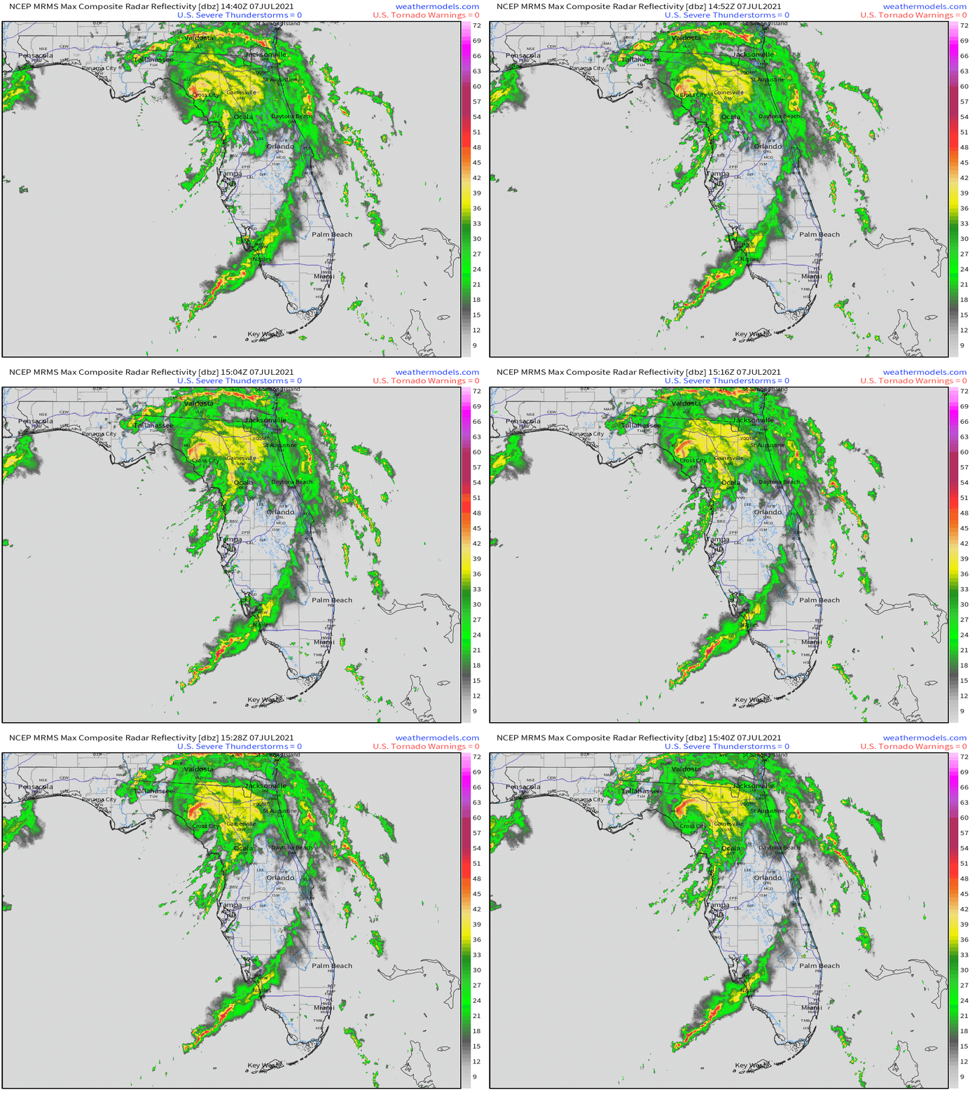
After bringing heavy rain and gusty winds to portions of the Caribbean and Florida over the past several days, Tropical Storm Elsa made landfall in northwestern Florida this morning. It’s not done yet though, not by a longshot.
Radar loop of Elsa making landfall Wednesday morning. Loop provided by Weathermodels.com
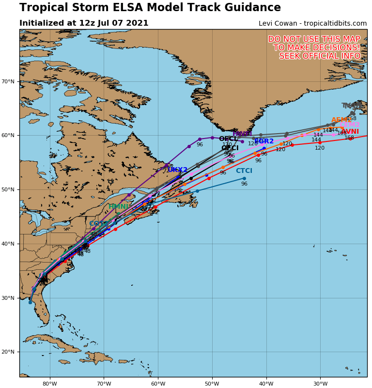
As of 2pm EDT, Tropical Storm Elsa was centered about 105 miles west of Jacksonville, Florida, moving toward the north at 14 mph. Maximum sustained winds have decreased to near 50 mph. Tropical Storm Warnings remain in effect for part of northwestern Florida, and for the Atlantic coast of Georgia and South Carolina. A Tropical Storm Watch is in effect north of there all the way up to northeastern New Jersey.
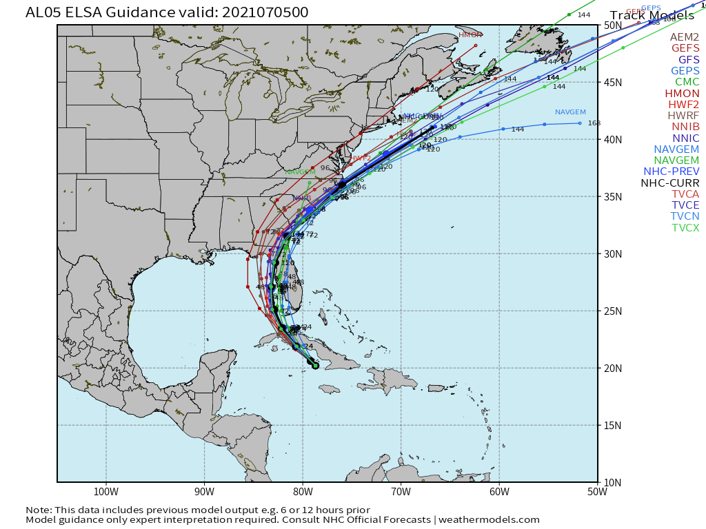
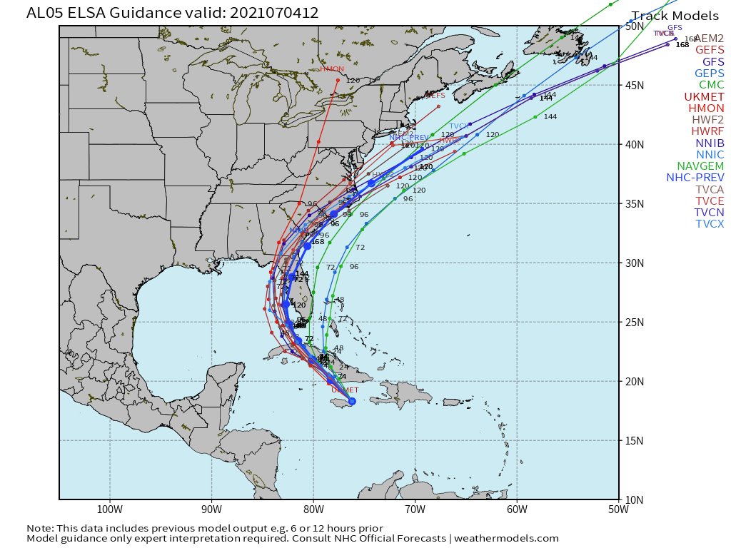
Model forecasts for the track of Elsa. Image provided by Tropical Tidbits.
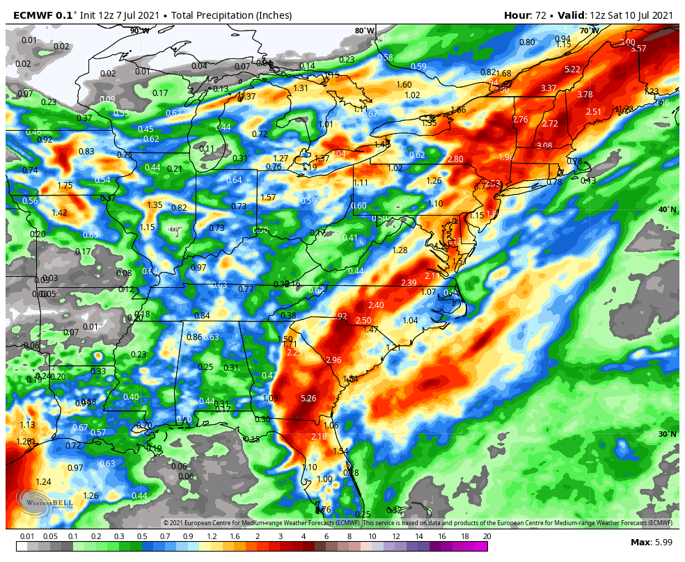
The forecast for the next 36 hours is fairly straightforward. Elsa will turn northeastward, moving across parts of Georgia, the Carolinas, and into Virginia while gradually weakening. Gusty winds, and heavy rain are likely, with rainfall totals of 3-5 inches and locally heavier likely producing flooding in many areas. In addition, to the east of the storm’s center, some tornadoes are also possible.
A tornado watch has been issued for parts of Florida and Georgia until 8 PM EDT pic.twitter.com/tbF3VM3nHT
Once it gets into the Mid-Atlantic states later Thursday, we have a bit of uncertainty in the forecast. Elsa will continue northeastward, and may start to become extratropical. When this happens, the stronger winds cover a larger area, compared to tropical systems, where the strongest winds are found very close to the center. Many models show Elsa starting to strengthen a bit again. This is likely when it is starting to become extratropical. Elsa may move back over water south of Long Island, but that will depend on when it begins to turn more toward the east-northeast. This has implications for Southern New England.
Elsa will produce heavy rain up and down the East Coast over the next few days. Image provided by WeatherBell.
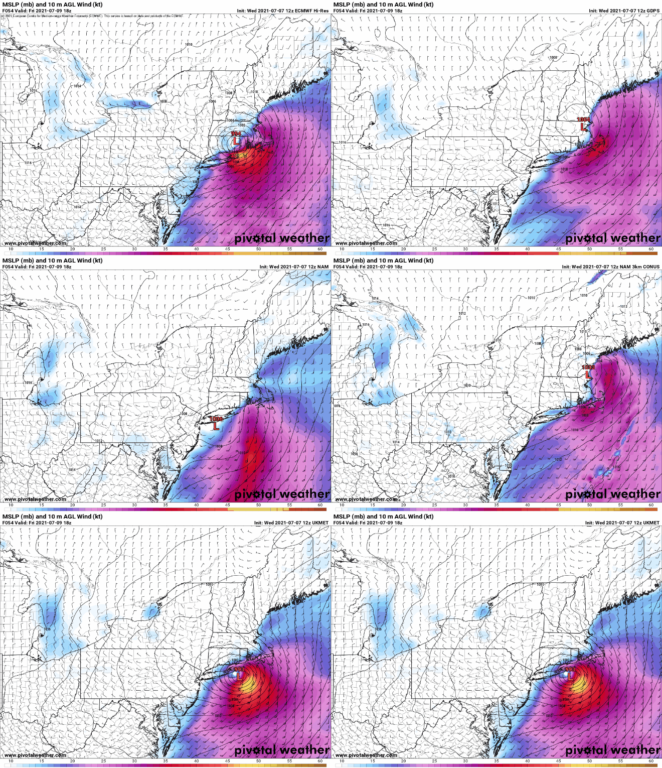
Elsa will continue to produce heavy rain and gusty winds across the Mid-Atlantic states and into Southern New England later Thursday into Friday. However, the strongest winds are found to the right of the center. If the storm passes near or just south of New England, that means that the strongest winds will stay offshore, possibly impacting Cape Cod and the Islands. However, if the storm stays inland, and moves across Southern New England, then a period of strong to damaging winds could impact parts of Connecticut, Rhode Island, and Southeastern Massachusetts on Friday. Sustained winds of 20-30 mph, with gusts of 50-60 mph would be possible. A track even farther to the west (which is possible), could result in those strong winds impacting the New York City, Providence, and Boston metropolitan areas on Friday.
Where will Elsa track in relation to southern New England? Images provided by Pivotal Weather.
Conditions will improve across New England on Saturday as Elsa (or what’s left of it) moves into Atlantic Canada, and beyond that, the Atlantic looks quiet for a while, which is fairly typical for early July. Plumes of Saharan Dust are making their way across the Atlantic and into the Caribbean, which suppresses tropical activity.
After a chilly and wet weekend, heat and humidity are set to return to the region.
Our pesky upper-level low pressure area finally pulls away and high pressure builds in today, bringing some sunshine and warmer temperatures back into the region. A warm front will move through tonight, and it may produce a few showers and thunderstorms, but the more noticeable impact will be an increase in humidity once again. This sets up a hot and humid day on Tuesday. Many locations may top 90, and heat indices will be well into the 90s across the region. A weak boundary will move in during the afternoon though, and this may trigger showers and thunderstorms, some of which could become strong to severe. Any storms that do form could produce gusty winds, frequent lightning, and heavy downpours. If you’ve got outdoor plans for Tuesday afternoon and evening, keep an eye to the sky and on the radar, and be prepared to head indoors.
Strong to severe thunderstorms may cross the region Tuesday afternoon. Loop provided by WeatherBell.
Wednesday looks to be very warm and humid once again, but temperatures will depend on how much cloud cover there is. A cold front will be approaching from the north and west, and this will produce another round of showers and thunderstorms during the afternoon and evening. This is where forecast confidence drops significantly. That front will eventually stall out near or just south of the region. Where it stalls out will have a big impact on Thursday temperatures, with warm and humid air still in place to the south, but cooler air to the north. Complicating things is the fact that a wave of low pressure may ride along the front, bringing in some rain once again.
The models have a wide variety of ideas about Thursday’s temperatures. Images provided by Pivotal Weather.
If Thursday wasn’t complicated enough, on Friday we may have to deal with Elsa or its remains. We’re not expecting Elsa to make a direct hit on New England. It should be heading out to sea well to the south. However, it may be close enough to interact with that frontal boundary, and send more rain into the region. It also may produce some gusty winds across the Cape and Islands, and some rough seas, especially along the South Coast.
Elsa or its remains should stay pass south of New England. Image provided by Weathermodels.com
We should dry out on Saturday with a warm day expected, but humidity will return on Sunday, along with the chance for more showers and thunderstorms as another frontal boundary approaches the region.
Monday: Becoming partly to mostly sunny. High 71-78.
Monday night: Partly cloudy, chance for a few showers or thunderstorms. Low 60-67.
Tuesday: Partly sunny, breezy at times, more humid, showers and thunderstorms are possible during the afternoon, some may be strong to severe. High 84-91, cooler along the South Coast.
Tuesday night: Any showers or storms end in the evening, otherwise partly cloudy. Low 65-72.
Wednesday: A mix of sun and clouds, humid, showers and thunderstorms possible during the afternoon and evening. High 84-91, cooler along the South Coast.
Thursday: Partly to mostly cloudy with a chance for rain or showers. High 76-83, possibly cooler across southern New Hampshire and northern Massachusetts.
Friday: Plenty of clouds, more rain or showers possible. High 77-84.
Saturday: Becoming partly sunny. High 77-84.
Sunday: Intervals of clouds and sunshine, showers and thunderstorms possible during the afternoon and evening. High 80-87.
Tropical Storm Elsa has its sights set on Cuba and Florida over the next couple of days.
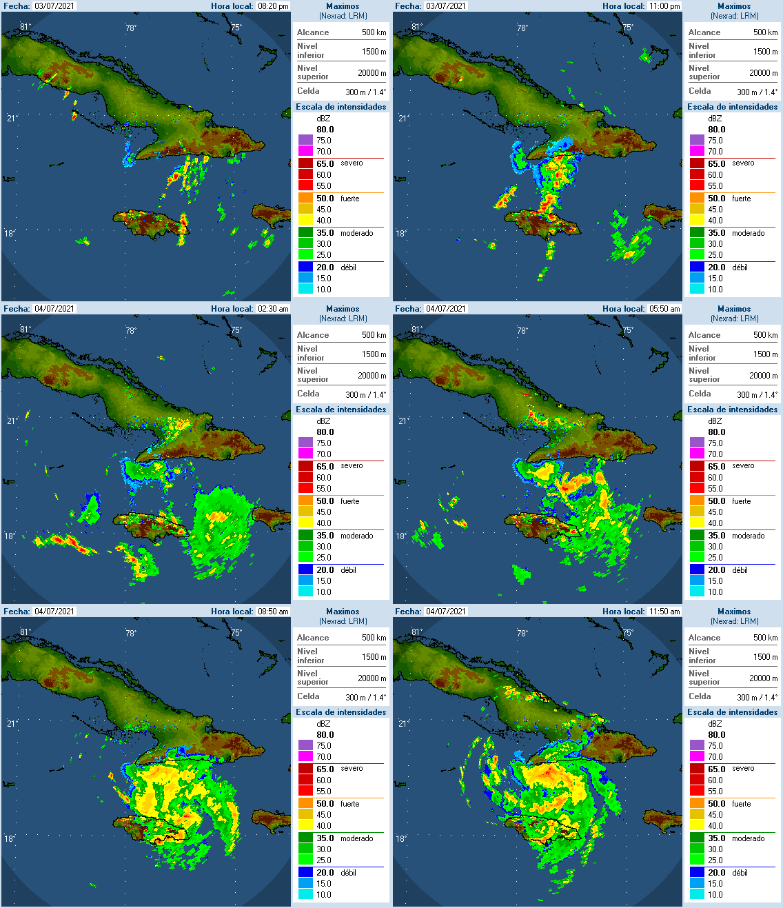
Radar from Cuba shows Elsa bringing heavy rain to Jamaica and parts of Cuba. Image provided by Brian McNoldy, Univ. of Miami, Rosenstiel School.
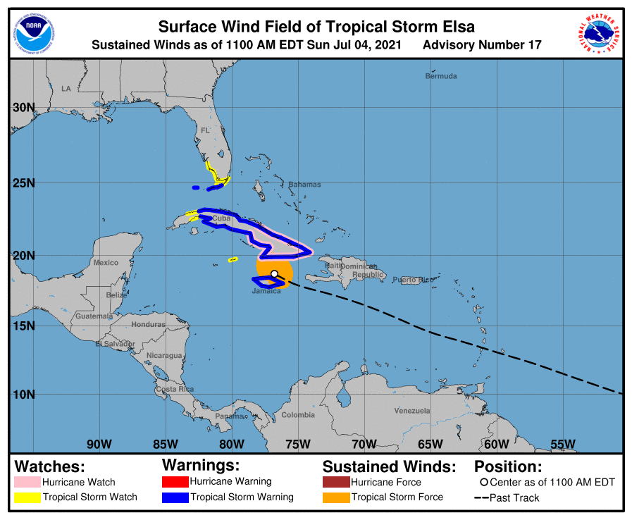
After weakening to a Tropical Storm, Elsa has been battering parts of the Dominican Republic, Haiti, and Jamaica with strong winds and heavy rainfall over the past couple of days. Cuba is starting to feel the effects, and they’ll become more widespread today and Monday. Tropical Storm Watches and Warnings are in effect for Jamaica, most of Cuba, parts of the Cayman Islands, as well as the Florida Keys and parts of South Florida.
Tropical Storm Watches and Warnings are in effect for parts of the Western Caribbean and South Florida. Image provided by the National Hurricane Center.
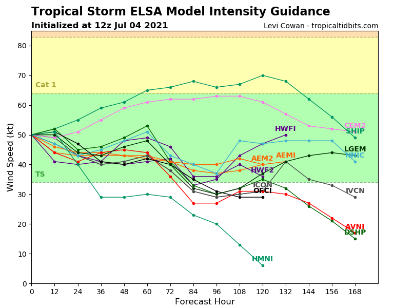
As of midday Sunday, Elsa was centered about 50 miles north of Kingston, Jamaica, moving toward the west-northwest at 13 mph. Maximum sustained winds were near 60 mph. While the storm may strengthen a little today, weakening is expected tonight as the center crosses Cuba. Once it reemerges in the Florida Straits on Monday, it will head northward toward the Florida Keys. While the water is plenty warm enough to support some intensification, shear will begin to increase as well, which acts to weaken the storm. The current forecast calls for the system to maintain its intensity Monday and Tuesday. Since intensity is usually the hardest thing to forecast in tropical systems, we wouldn’t be surprised if it re-intensified back into a hurricane, nor would we be surprised if it continued to weaken as it is moving northward off the west coast of Florida.
Some models show Elsa intensifying again after crossing Cuba, others don’t. Image provided by Tropical Tidbits.
Once Elsa crosses the Florida Keys it will continue northward, eventually turning northeastward as it moves around the edge of a large ridge of high pressure centered over the western Atlantic. When it starts making that northeast turn will determine where landfall is expected in Florida. At this point, anywhere from Fort Myers to Pensacola could be the spot. Either way, heavy rain is likely across Florida over the next couple of days, especially western Florida. Rainfall totals of 4-8 inches and locally heavier will result in flooding in some areas.
Model forecasts for the track of Tropical Storm Elsa. Image provided by Weathermodels.com
Once it makes the turn, we have another question that we can’t answer yet – when will the center re-emerge over the Atlantic? Obviously, the longer it remains over land, the weaker it will be, but if it were to move offshore closer to northern Florida or Georgia instead of over North Carolina, there would be a window for a little strengthening as it moves over the warm waters of the Gulf Stream. Either way, it will bring heavy rain and gusty winds to parts of Georgia and the Carolinas toward the middle of the week. Once it moves back offshore, it should continue northeastward and out to sea while becoming extratropical later this week. Depending on how far north it actually gets, it could interact with a frontal system and bring some rainfall to parts of eastern New England by the end of the week, but there’s a lot that has to happen first before we can have any clarity on that possibility.
After starting hurricane season with 4 “tropical storms” that were probably not tropical, the first hurricane of the season has developed.
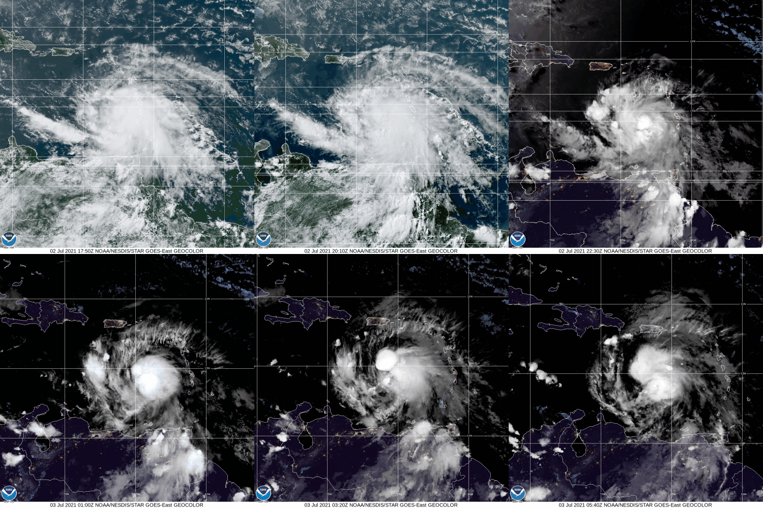
Hurricane Elsa formed as Tropical Depression Five late Wednesday night well east of the Lesser Antilles, and became Tropical Storm Elsa on Thursday. It rapidly intensified into a hurricane Friday morning as it approached Barbados. As Elsa crossed the Windward Islands Friday morning/early afternoon it produced wind gusts as high as 86 mph on Barbados and 79 mph on Saint Lucia. This is the earliest in the season that a storm has hit Barbados, and it is the 2nd earliest Hurricane ever in the eastern Caribbean, trailing only an unnamed storm from 1933.
Satellite loop of Hurricane Elsa. Loop provided by NOAA.
As of 2am Saturday, Hurricane Elsa was centered approximately 620 miles east-southeast of Kingston, Jamaica, moving toward the west-northwest at 29 mph. Maximum sustained winds are near 80 mph.
Hurricane Warnings are in effect for southern portions of the Dominican Republic and Haiti, as well as for the island of Jamaica, with Tropical Storm Warnings for the remainder of the Dominican Republic and Haiti. A Hurricane Watch is in effect for parts of eastern Cuba, and a Tropical Storm Watch is in effect for parts of the Cayman Islands.
Watches and Warnings associated with Hurricane Elsa. Image provided by the National Hurricane Center.
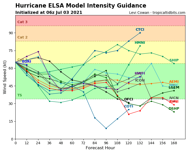
Elsa could strengthen a bit on Saturday, but for the most part, weakening is forecast. Some dry air got entrained in the circulation late Friday, okus the current rapid forward speed with both serve to inhibit any further strengthening, Although Elsa is expected to slow down over the next 24 hours, a turn more toward the northwest is expected. This will bring the storm closer to Hispaniola, where the mountainous terrain could disrupt the circulation as well.
Model forecasts for the intensity of Hurricane Elsa. Image provided by Weathermodels.com.
Current forecasts bring the center of the storm close to southern Haiti Saturday night, then toward southeastern and southern Cuba on Sunday. The intensity of the storm will be determined partially by the track the storm takes. The longer the circulation center stays over water, the better chance that the storm is stronger.
Model forecasts for the track of Hurricane Elsa. Image provided by Weathermodels.com.
As the storm slows down, it increases the chances for heavy rainfall across southern portions of Hispaniola, eastern and southern Cuba, and parts of Jamaica. Rainfall totals of 6-12 inches and locally heavier will lead to flooding and mudslides.
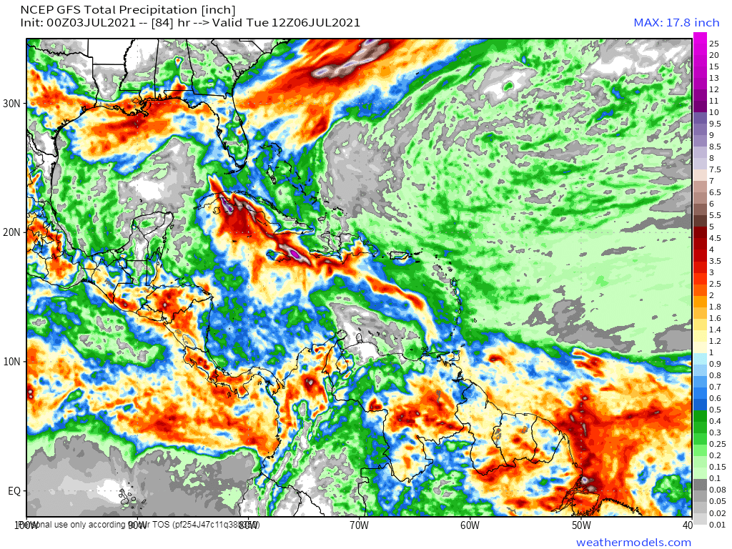
Elsa will bring heavy rainfall to portions of the Caribbean. Image provided by Weathermodels.com
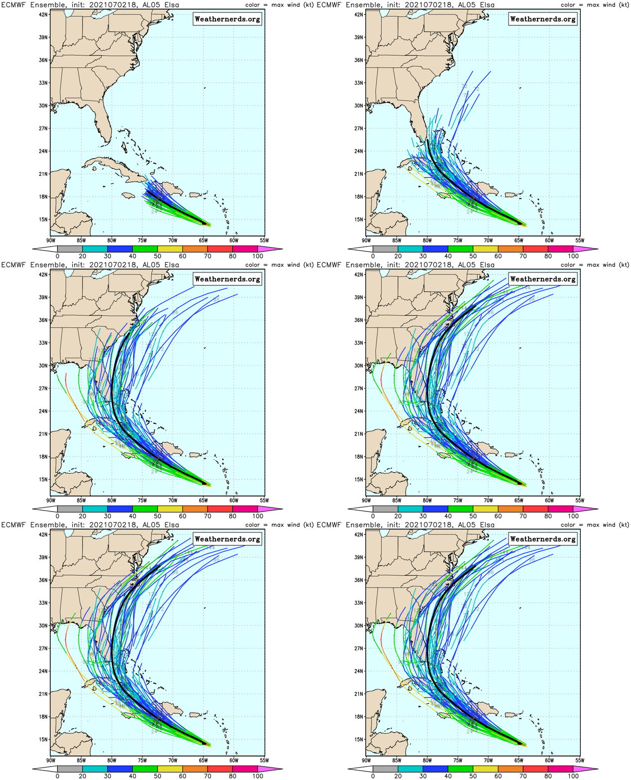
Elsa is expected to cross Cuba on Monday while turning northward. Given that this is already three days out, the uncertainty in the forecast becomes much large. A track towards Florida seems likely, but is far from definite at this point. Several models bring the storm up the west coast of Florida, while many others bring it up the east coast or even over the Bahamas. How strong the storm is at this point is also highly uncertain. Residents from the central Gulf Coast all the way to the Carolinas should keep tabs on the system this weekend, as it has the potential to impact anywhere within that range by the early to middle portion of next week.
Forecasts for Elsa’s track from the 51 members of the ECMWF Ensemble. Image provided by Weatehrnerds.org
Elsewhere, the tropics remain fairly quiet, with no other organized systems at this time.
It’s a long holiday weekend for most of you, but unfortunately, it’s not going to be all sunshine and warm temperatures.
What’s left of the warm and humid weather disappears overnight as a frontal boundary settles south of the region. This will bring in showers and thunderstorms, some of which may produce heavy rain. The front stalls out to our south on Friday, with waves of low pressure riding along it, bringing in more showers, along with much cooler conditions. Some of the models are forecasting very heavy rainfall across the region, which could lead to some areas of flooding. We’re not quite sure we believe some of these numbers, but your lawn should definitely get a big drink of water over the next few days.
Parts of the region could see quite a bit of rain this weekend. Images provided by Pivotal Weather,
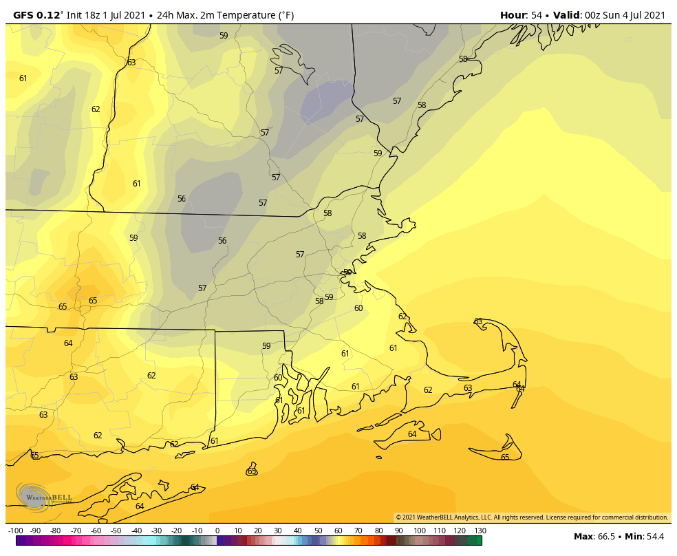
Over the weekend, the front washes out, but an upper-level low pressure system will slowly move across the region. This will keep clouds and cool temperatures in place, especially on Saturday, with some occasional showers, but neither day looks to be a washout. While Sunday isn’t ideal barbecue weather for the Fourth of July, it may not be THAT bad. Just keep an eye on the radar if you do have outdoor plans. By Monday, the upper low moves out, and we get back into sunshine and temperatures closer to normal for early July.
Some models try to keep it very cool around here on Saturday. Image provided by WeatherBell.
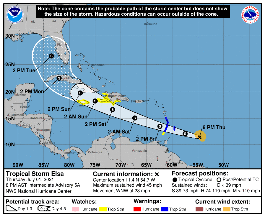
In the tropics, Tropical Storm Elsa was centered about 345 miles east-southeast of Barbados this evening, moving toward the west-northwest at 28 mph. Maximum sustained winds are near 45 mph. Tropical Storm Watches and Warnings are in effect for various islands in the eastern and northern Caribbean. The current forecast calls for some strengthening, as conditions remain favorable for the next day or so, but unless it slows down, it won’t strengthen too much. We’ll take a much more in-depth look at Elsa in a special blog post either Friday afternoon or evening.
Forecast track for Tropical Storm Elsa. Image provided by the National Hurricane Center.
Thursday night: Cloudy with periods of rain and showers and some embedded thunderstorms. Low 59-66, a little milder near the South Coast.
Friday: Mostly cloudy with more showers, especially in the morning. High 64-71. Offshore: Winds becoming northeast to north 10-15 knots, gusts to 20 knots, seas 3-6 feet, visibility under 1 mile in showers and fog.
Friday night: Plenty of clouds with more showers likely. Low 53-60.
Saturday: Mostly cloudy and cool with occasional showers. High 59-66. Offshore: Northeast 10-20 knots gusts to 25 knots, seas 3-6 feet, visibility 1-3 miles in showers and fog.
Saturday night: Mostly cloudy, chance for a few showers. Low 51-58.
Fourth of July: Clouds and some sunny breaks with more showers possible. High 65-72. Offshore: Northwest 10-15 knots, seas 3-6 feet, visibility 1-3 miles in showers and fog.
Sunday night: Showers end in the evening, some clearing late at night. Low 52-59.
Monday: Partly to mostly sunny. High 74-81. Offshore: Southwest 10-20 knots, seas 3-5 feet, visibility 10 miles or better.
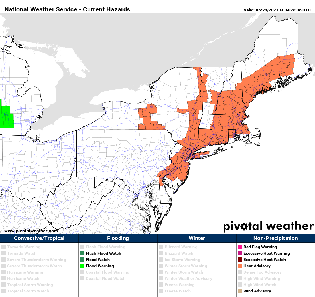
If you like heat and humidity, then the first half of the week is perfect for you. If you don’t, well, the end of the week and the weekend might be better, but certainly not perfect.
Heat Advisories are in effect for much of the Northeast today. Image provided by Pivotal Weather.
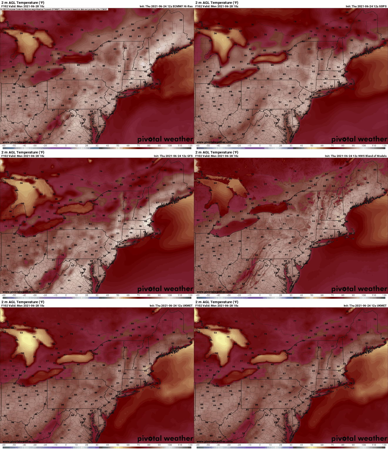
We start the week off with high pressure anchored off the Eastern Seaboard, pumping hot and humid air into the region. Most locations away from the South Coast should get well into the 90s today, tomorrow, and Wednesday. With the humidity factored in, it’s going to feel like it’s near or over 100 degrees. That’s why Heat Advisories have been issued for much of the area. At night, it’ll remain warm and muggy, with lows generally in the 70s. A few showers and thunderstorms may pop up Tuesday and again on Wednesday afternoon, providing a little late-day relief.
Tuesday looks like the hottest day, but we think the GFS might be overdoing things a little on Wednesday. Image provided by WeatherBell.
A cold front will move in late Wednesday or early Thursday, taking the edge off the heat, but with some more widespread showers and thunderstorms accompanying it. Beyond that, things get a little tricky. That front is expected to wash out near or just south of the region on Thursday. Waves of low pressure will ride along it, with showers and thunderstorms possible at times from Friday into the weekend, but this will also depend on how much southward progress the front makes before it washes out. If it’s far enough to the south, then the shower activity may stay a little farther south. No matter where it stalls, we’re looking at one or possibly two very cool days for the end of the week and start of the weekend. Temperatures should start to moderate again for the Fourth of July.
Temperatures on Friday could be 30-40 degrees cooler than Wednesday, if you believe the GFS. Image provided by Weathermodels.com
Monday: Partly sunny, hot, and humid. High 90-97, cooler along the South Coast.
Monday night: Clear to partly cloudy, just a slight chance for a shower or two. Low 70-77.
Tuesday: Sunshine and some afternoon clouds, hot, and humid., a few showers and thunderstorms are possible late in the day. High 91-98, cooler along the South Coast.
Tuesday night: Clear to partly cloudy, any showers or storms end during the evening. Low 69-76.
Wednesday: Partly to mostly sunny, breezy, hot, and humid, showers and thunderstorms are possible during the afternoon and evening. High 89-96 cooler along the South Coast.
Thursday: More clouds than sun with scattered showers and thunderstorms. High 81-88.
Friday: Plenty of clouds and much cooler with more showers possible, especially south of the Mass Pike. High 71-78.
Saturday: Partly to mostly cloudy, chance for showers and thunderstorms. High 68-75.
Fourth of July: More clouds than sun with more showers and thunderstorms possible. High 74-81.
The first full weekend of summer will feature a return of humidity and heat to the region.
A warm front will cross the region late tonight and early Friday. A few showers may accompany the front, maybe even a rumble of thunder, but they should be gone before midday, and they shouldn’t be that heavy either. Skies will start to clear out in the afternoon, and you’ll start to notice the increase in humidity. With the cloud cover likely hanging on through early afternoon, temperatures may not get that warm, especially along the Maine and New Hampshire Seacoast, where the front will take the longest to move through.
Dewpoints will jump into the middle to upper 60s on Saturday behind the warm front. Image provided by WeatherBell.
The rest of the weekend and Monday will feature typical summertime weather, with sunshine and afternoon clouds, along with a few pop-up showers and thunderstorms. We’ll have a frontal boundary well to our north and west, so we shouldn’t expect any organized severe weather with the front too far away, but any storms that do form could produce some localized downpours and gusty winds. In terms of temperatures, Sunday and Monday look quite toasty, and some models have temperatures getting well into the 90s away from the South Coast. The heat and humidity look to persist into at least the middle of next week.
Monday is looking like it’s going to be hot. Images provided by Pivotal Weather.
Thursday night: Increasing clouds with some showers possible late at night. Low 51-58, but temperatures may start to rise a bit after midnight, especially south of Boston
Friday: Any showers ending in the morning, some partial sunshine develops in the afternoon. High 72-79. Offshore: Southeast to south winds 10-15 knots, seas 2-4 feet.
Friday night: Partly to mostly cloudy. Low 59-66.
Saturday: Partly sunny, slight chance for a shower or thunderstorm. High 80-87. Offshore: South to southwest winds 10-15 knots, seas 2-4 feet.
Saturday night: Partly to mostly cloudy. Low 66-73.
Sunday: A mix of sun and clouds, slight chance for a shower or thunderstorm. High 85-92, cooler along the South Coast. Offshore: Southwest winds 10-20 knots, seas 3-5 feet.
Sunday night: Partly cloudy. Low 67-74.
Monday: Partly sunny, a late-day shower or thunderstorm is possible. High 89-96, cooler along the South Coast. Offshore: Southwest winds 10-20 knots, seas 3-5 feet.
Finally, we’re just going to touch on a couple of other topics. As you may have heard, some incredible heat is expected in the Pacific Northwest this weekend and early next week. Places like Portland, Seattle, and Spokane could shatter all-time records, with temperatures possibly topping 110 degrees. Meanwhile, in the tropics, a rather robust wave has moved off the coast of Africa, and some of the models show the potential for this wave to develop as it crosses the Atlantic. It’s a little early in the season for easterly waves, but we’ll keep an eye on its progress. We plan to write a special blog post on Friday that will cover both of these topics in greater detail.








 Storm HQ