Weekly Outlook: May 16-22, 2022

We’re starting the week with a bang, as a strong cold front may produce some severe weather today.

Once the fog near the South Coast burns off this morning, we’ll have partly sunny skies today and it will be warm and somewhat humid. However, a strong cold front will move across the region later today, bringing an end to the humidity and mild temperatures. Ahead of that front, showers and thunderstorms are expected this afternoon into part of the evening. The bulk of the severe weather should stay to our west, but some of the storms that make it this far east could still produce gusty winds, small hail, and heavy downpours.

The farther west you go, the more likely severe weather becomes today. image provided by NOAA.

Behind the front, an upper-level low pressure system will cross the Northeast on Tuesday, generating some clouds and possibly a stray shower or two. High pressure then builds in for Wednesday and Thursday with dry and seasonably mild conditions. By Friday, a warm front will move across the region, allowing warmer and more humid air to move back into the region, Saturday looks like it will be the warmest day, with temperatures possibly topping 90 in much of the region. The latter half of the weekend is a bit trickier. A cold front will move through, with some showers and thunderstorms likely, but the timing of the front is still in question, which has significant implications for the temperature forecast on Sunday. If the front moves through Sunday afternoon, as some models are showing, then another hot day is likely, but if it moves through Saturday night, as other models are indicating, then we’ll clear out after some morning showers, but temperatures will be significantly cooler. We’re going to play the middle ground for now, and hope for some clarity by the time we get to our Weekend Outlook on Thursday.

Sunday could be another hot day, but how hot? Images provided b Pivotal Weather.

Monday: Morning fog along the South Coast, otherwise a mix of sun and clouds with showers and thunderstorms developing during the afternoon, some of which may contain gusty winds, hail, and heavy downpours. High 77-84, cooler along the coast.

Monday night: Showers and storms end in the evening, skies start to clear out after midnight. Low 51-58.

Tuesday: Sunshine and some afternoon clouds, slight chance for a stray shower, breezy. High 68-75.

Tuesday night: Mostly clear. Low 45-52.

Wednesday: Plenty of sunshine, breezy again. High 65-72.

Thursday: A mix of sun and clouds. High 66-723.

Friday: Partly sunny. High 75-82, cooler along the coast.

Saturday: Partly to mostly sunny. High 86-93, cooler along the coast.

Sunday: A mix of sun and clouds with a chance for showers and thunderstorms. High 77-84.

Weekend Outlook: May 13-16, 2022

Warm weather is finally here, and with it mostly dry weather, but that’s not a completely good thing.

High pressure will continue to build into the region over the next few days before sliding offshore. At the same time, the low pressure that has been sitting off the East Coast for the last several days while move into the Southeast and dissipate, but that doesn’t mean it won’t impact our weather.

Low pressure is close to the Carolina coast this afternoon, but it is impacting the weather as far north as southern New England. Loop provided by NOAA.

With winds still coming off the ocean, we’ll have plenty of moisture around tonight, resulting in low clouds and fog, especially along the coastal plain. Once it burns off Friday morning we’ll have partly to mostly sunny skies, though the clouds may hang tough across parts of southeastern Massachusetts and Cape Cod. Areas that break out into the sunshine should see temperatures well into the 70s and 80s thanks to southerly winds, though that will keep areas with south-facing coastlines significantly cooler. We may see a little fog Friday night once again. By Saturday, winds will shift into the southwest, resulting in warm weather across most of the region, except for south-facing shorelines once again. We’ll probably have a bit more cloudcover across the region, but it will still be at least partly sunny. A couple of showers and thunderstorms may pop up during the afternoon across the interior. Sunday looks to be similar, but showers may be a bit more numerous as the moisture from that old low pressure system works its way up the coastline. The day won’t be a washout by any means, but if you’ve got outdoor plans in the afternoon, keep an eye on the sky (or the radar).

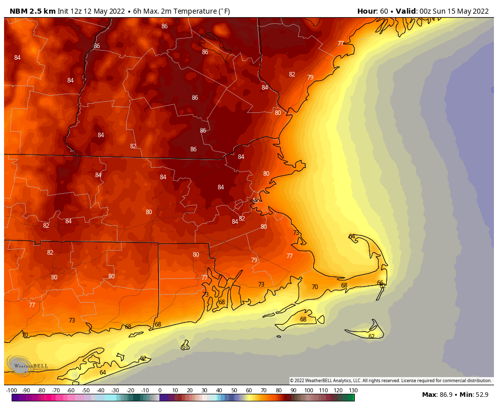
Saturday looks to be an absolutely fantastic mid-May day. Image provided by WeatherBell.

By Monday, we’ll have a cold front approaching from the west. It’ll still be quite warm, but we’ll have more clouds, and more widespread showers and thunderstorms, mainly late in the day. Given how dry it’s been lately, we actually need the rain, though it doesn’t look like this will produce a lot of rain. We’ve had some brush fires locally in recent weeks, and drought conditions are beginning to develop in parts of the region. We really could use some rain to help alleviate that.

Thursday night: Becoming mostly cloudy with patchy dense fog. Low 50-57.

Friday: Becoming partly to mostly sunny, though it may remain mostly cloudy near the South Coast and across Cape Cod. High 68-75 near the coast, 76-83 inland.

Friday night: Clouds return, fog may redevelop across southeastern Massachusetts. Low 55-62.

Saturday: Partly sunny, slight chance for an afternoon shower or thunderstorm across the interior. High 79-86, cooler along south-facing shorelines.

Saturday night: Partly to mostly cloudy, fog may redevelop across the South Coast and Cape Cod. Low 57-64.

Sunday: Partly sunny, a late-day shower or thunderstorm is possible. High 78-85, cooler along south-facing shorelines.

Sunday night: Partly to mostly cloudy. Low 54-61.

Monday: Intervals of clouds and sun, showers and thunderstorms possible late in the day. High 74-81, cooler along south-facing shorelines.

Weekly Outlook: May 9-15, 2022

We’ve got a rather simple forecast for most of the upcoming week, and you’re probably going to like it.

Low pressure continues to drift southward off the Mid-Atlantic coastline today while high pressure builds into southeastern Canada. The result will be sunshine, but we’ll still have some gusty east to northeast winds keeping us on the cool side, especially near the coast. By Tuesday, the low drifts farther to the south, though some moisture rotating around it may produce a shower or two across parts of eastern Massachusetts. Otherwise, the high will continue to build in with sunshine, but it will still remain breezy and one the cool side. Temperatures moderate a bit more on Wednesday as winds diminish, but it will still be on the cool side at the coast. The latter half of the week and start of the week is when the big changes occur.

Temperatures will be 5-10 degrees below normal across the region again today. Image provided by Weathermodels.com

High pressure slides offshore for Thursday, and remains there into Saturday. The result will be sunshine and much warmer temperatures. How warm? How does highs in the 70s and 80s sound? A seabreeze will keep coastal areas cooler, but away from the shoreline? Break out the shorts and open the sunroof. Some models even show the potential for temperatures to get close to 90 on Saturday. By Sunday, a cold front will be approaching with some showers likely along with cooler temperatures. How cool is still a bit up in the air, but we’ll worry about that more in our weekend outlook on Thursday.

Saturday looks like a fantastic day. Image provided by WeatherBell.

Monday: Morning clouds give way to afternoon sunshine, windy. High 57-64, cooler along the coast.

Monday night: Mostly clear. Low 37-44.

Tuesday: Sunshine and a few clouds, breezy. High 60-67 inland, 53-60 along the coast.

Tuesday night: Partly cloudy, slight chance for a shower. Low 38-45.

Wednesday: Partly sunny, an isolated shower can’t be ruled out. High 65-72 inland, 58-65 along the coast.

Thursday: A mix of sun and clouds, warmer. High 76-83, cooler along the coast.

Friday: Partly to mostly sunny. High 79-86, cooler along the coast.

Saturday: Partly sunny. High 79-86, cooler along the coast.

Sunday: Mostly cloudy with a chance of showers. High 69-76, cooler along the coast.

Weekend Outlook: May 6-9, 2022

For parts of the region, we’ve got a decent weekend coming up, for other parts, not so much.

While you’re enjoying today’s sunshine and mild temperatures, changes are coming. High pressure will build in to our north while low pressure slowly moves toward and then off the Mid-Atlantic coastline before stalling out south of New England. We’ll be caught in between these two for the next several days. We’ll see clouds streaming in tonight ahead of the low pressure system. Some rain will spread in for Friday afternoon into Saturday, but the northern extent of the rain is still a bit of a question mark. Some models keep it confined to just the South Coast, some bring it up into the Merrimack Valley. We’re going with a compromise for now, with rain mainly south of the Mass Pike, but plenty of clouds everywhere. We’ll also have some gusty east to northeast winds through the weekend, which combined with the clouds and rain will result in a few rather chilly days. By later Sunday into Monday, the storm will start to drift southward while the high to our north builds in, with skies eventually clearing and temperatures starting to moderate, especially away from the shoreline.

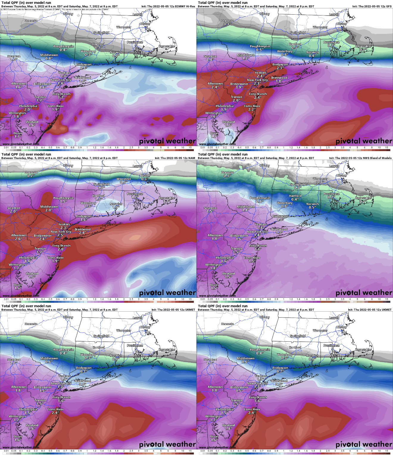
How far north will the rain get for Friday and Saturday? The models don’t completely agree yet. Images provided by Pivotal Weather.

Thursday night: Becoming mostly cloudy. Low 42-49.

Friday: Mostly cloudy with rain developing, mainly south of Mass Pike. High 59-66.

Friday night: Periods of rain and showers, mainly south of the Mass Pike. Low 40-47.

Saturday: Cloudy and breezy with showers ending. High 48-55.

Saturday night: Mostly cloudy and breezy. Low 37-44.

Sunday: More clouds than sunshine. breezy. High 51-58, warmest well inland.

Sunday night: Partly to mostly cloudy, breezy. Low 36-43.

Monday: Partly sunny and breezy. High 49-56 along the coast, 56-63 inland.

A warming trend could be on the way later next week. Image provided by WeatherBell.

Finally, just a sneak peek at next week shows the potential for a significant warmup around here for the latter half of next week and into next weekend. Some models are showing the potential for at least few days where the first number of high temperature is an “8”. Now, it’s a week away, and things can change, plus, we’ve got the very chilly Atlantic right here which always can complicate things at this time of year, but we figured we’d let you know that there is the chance for things to finally feel likely May. For now, it’s just potential, but we’ll update you in our Weekly Outlook Monday morning.

Weekly Outlook: May 2-8, 2022

Looks like some wet weather is on the way this week, but that’s a good thing, because we need it.

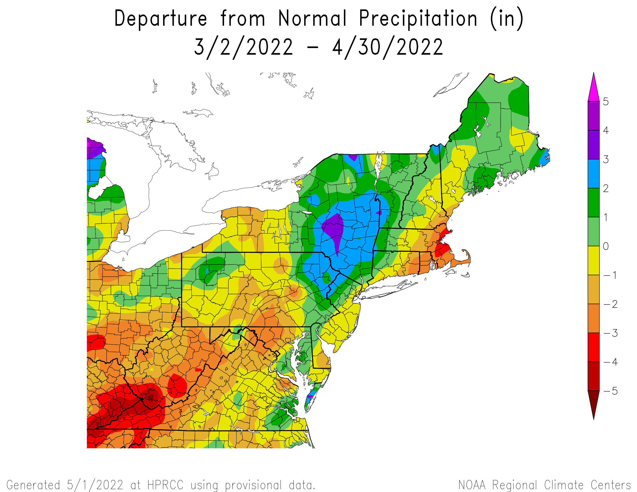
March and April have been very dry across a good portion of the region. Image provided by the Northeast Regional Climate Center.

We start the week off with a warm front trying to move into the region today. It won’t get here, so we’ll stay cool but the rain ahead of the front will get here, with some showers likely this afternoon and tonight. High pressure tries to build in on Tuesday with some drier weather, but the clouds and cool temperatures will hang around. The next system quickly follows on Wednesday, with another round of rain likely. High pressure builds in for Thursday and this time we will clear out with some milder temperatures.

Thursday looks like the pick of the week. Image provided by WeatherBell.

The end of the week and the weekend remain very uncertain at this point. We’ll have high pressure trying to build in from the north while low pressure moves across the Ohio Valley and then off the Mid-Atlantic coast, passing south of us. The question is, how far south? The models don’t agree on this at all, and that’s the difference between a rainy and chilly Friday and Saturday, or rain confined to areas south of the Mass Pike, or the rain staying completely offshore with some sunshine possible. We hope to have a better idea on this by the time we get to our Weekend Outlook on Thursday. Sunday looks to be a decent day right now with high pressure building in, but that will be influenced by what happens on Friday and Saturday, so it can change.

The models do not agree on what will happen with a storm system next weekend. Images provided by Pivotal Weather.

Monday: Cloudy with showers likely, mainly during the afternoon and evening. High 55-62, cooler along the coast.

Monday night: Showers ending, remaining cloudy. Low 39-46.

Tuesday: Clouds and some afternoon sunny breaks. High 52-59.

Tuesday night: Mostly cloudy, showers possible late at night. Low 39-46.

Wednesday: Cloudy with rain developing. High 48-55.

Thursday: A mix of sun and clouds. High 62-69, cooler along the coast.

Friday: Cloudy with a chance of showers. High 57-64.

Saturday: Cloudy with a chance of showers. High 49-56.

Sunday: Partly to mostly sunny. High 55-62.

Weekend Outlook: April 29 – May 2, 2022

As we get ready to flip the calendar from April to May, we’ve actually got a rather nice weekend coming up.

Low pressure will continue to meander around east of the the region into Saturday while high pressure builds in from the west. We’ll be stuck in the middle with patches of clouds, gusty winds, (especially on Friday) and relatively cool temperatures. By Sunday, the low is far enough to the east to allow the high to take control, meaning sunshine and milder temperatures. However, don’t get too used to it. Another system will start to approach on Monday. We’ll see clouds streaming in, but for now at least, it looks like the day should remain dry, with any rain likely holding off until evening or at night.

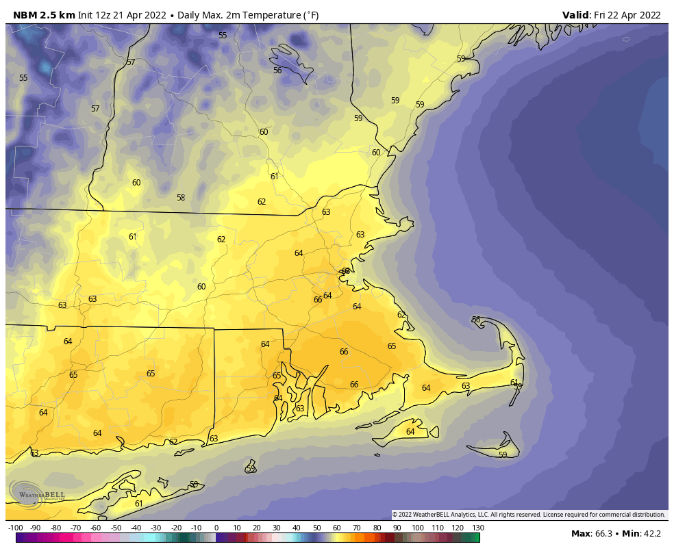
High temperatures should be in the lower to middle 60s for most of us at the end of April. Image provided by Weathermodels.com

Thursday night: Clear and chilly. Low 30-37.

Friday: Morning sun, afternoon clouds, breezy. High 49-56.

Friday night: Clear to partly cloudy. Low 33-40.

Saturday: Partly sunny. High 52-59.

Saturday night: Clear skies. Low 34-41.

Sunday: Plenty of sunshine. High 61-68, a little cooler right at the coast.

Sunday night: Clear during the evening, clouds start to filter in late at night. Low 37-44.

Monday: Increasing and thickening clouds. High 57-64.

Weekly Outlook: April 25 – May 1, 2022

As we enter the final days of April, we’re not looking at a lot of warm weather this week.

Today looks to be the pick of the week with high pressure building in. We’ll have some sunshine, but temperatures will be on the cool side again, especially along the coast thanks to an onshore flow. Clouds start to move in late in the day as a cold front starts to approach the region. That front will bring in some showers later Tuesday into early Wednesday as it moves through and a wave of low pressure rides along it. Once it pushes offshore, an upper-level low pressure area will slowly move across the Northeast, keeping us rather cool with a decent amount of clouds for Thursday and Friday, possibly even lingering into Saturday. By Sunday, high pressure will build back in with milder temperatures returning.

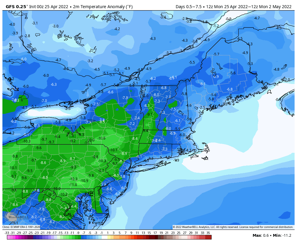
A rather chilly week is expected across the Northeast. Image provided by WeatherBell.

Monday: Partly sunny. High 56-63, a little cooler right at the coast.

Monday night: Becoming mostly cloudy. Low 38-45.

Tuesday: Mostly cloudy with showers developing late in the day. High 57-64.

Tuesday night: Cloudy with showers likely. Low 41-48.

Wednesday: Showers end early, some afternoon sunny breaks may develop. High 53-60.

Thursday: A mix of sun and clouds, breezy. High 49-56.

Friday: Sunshine with afternoon clouds, breezy. High 49-56.

Saturday: Partly sunny. High 50-57.

Sunday: A mix of sun and clouds. High 55-62.

Weekend Outlook: April 22-25, 2022

We’ve got a fairly decent weekend coming up with some typical springtime weather, which means keep the jackets handy.

A few showers are likely this evening and tonight as a cold front crosses the region, then high pressure builds in for Friday with sunshine and milder temperatures. The cooler air starts to settle in Friday night. With high pressure building in to the north we’ll turn cooler for Saturday, with clouds moving in during the day as a backdoor cold front starts to slide down the coastline. That front may produce a few showers when it comes through Saturday evening, then Sunday will feature plenty of clouds and rather cool temperatures thanks to an east wind off the still chilly Atlantic. Temperatures will only be in the 40s at the coast and several miles inland, with 50s a little farther inland. You won’t have to go too far to find milder weather, as that front will likely stall out across southwestern New England, so temperatures could be in the 60s and 70s from southwestern Connecticut into the New York City area. That front may try to lift northward again as a warm front, and while it probably won’t get back here, temperatures will start to warm up a bit on Monday as winds will no longer be off the water. However, we’ll still have plenty of clouds as another storm system will start to approach from the west.

Friday is the pick of the weekend with sunshine and temperatures well into the 60s. Image provided by WeatherBell.

Thursday night: Cloudy with a few showers this evening, skies start to clear out late at night. Low 41-48.

Friday: Plenty of sunshine, breezy. High 60-67.

Friday night: Clear skies. Low 34-41.

Saturday: Sunny early, clouds move in and thicken up during the afternoon. High 56-63.

Saturday night: Mostly cloudy, chance for a few showers during the evening. Low 38-45.

Sunday: More clouds than sunshine. High 44-51 along the coast, 51-58 inland.

Sunday night: Partly to mostly cloudy. Low 37-44.

Monday: Intervals of clouds and sun. High 57-64.

Weekly Outlook: April 18-24, 2022

“April is the cruelest month, breeding lilacs out of the dead land, mixing memory and desire, stirring dull roots with spring rain.” – T.S. Eliot

We had temperatures above 70 on Friday and Saturday, and now there might be snow in the forecast? Ah yes, April can indeed be the cruelest month.

We start the week off on a chilly note with high pressure in control, but with sunshine this morning, temperatures will rise into the 50s this afternoon, which is a few degrees below normal. Clouds will start to stream in this afternoon as low pressure begins to head up the East Coast. We’ll have a period of rain and gusty winds Monday night into Tuesday, but across the interior, especially in the hills from Worcester County into southern New Hampshire, there will likely be some snow, with some accumulations likely. Even at the lower elevations, especially from southern New Hampshire into the Merrimack Valley, we could have some wet snow mix in, but if there’s any accumulation in these areas, it will be very minor and confined to grassy surfaces.

Any snow is likely confined to the hills and areas well north and west. Image provided by WeatherBell.

Skies start to clear out Tuesday afternoon as high pressure builds back in, with dry and seasonably cool conditions into Wednesday. We’ll start to warm up again on Thursday ahead of another frontal system, that could bring in a few showers for Thursday night and early Friday. High pressure builds back in for the weekend with mild temperatures for at least Saturday, but Sunday could turn cooler as a backdoor cold front may slide down the coastline.

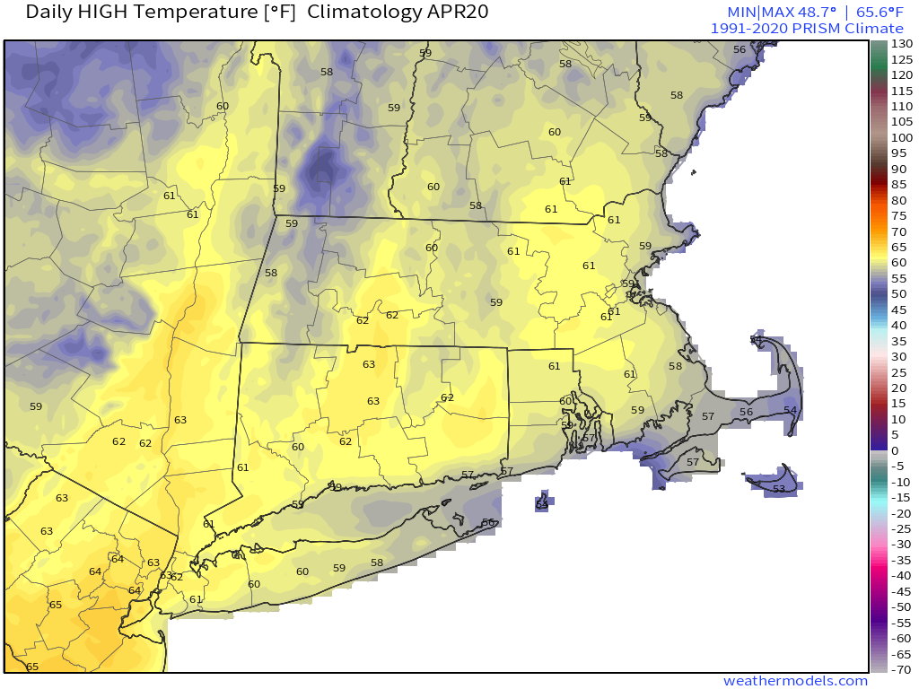
Average high temperatures in mid-April are right around 60 degrees. Image provided by Weathermodels.com

Monday: Sunny and chilly early, clouds start to filter in and thicken up during the afternoon. High 50-57.

Monday night: Rain developing, mixed with snow across the hills and well inland, breezy. Low 36-43.

Tuesday: Breezy with rain (or snow) ending in the morning, some clearing in the afternoon. High 50-57.

Tuesday night: Becoming mostly clear. Low 34-41.

Wednesday: Mostly sunny and breezy, clouds may start to move back in late in the day. High 51-58.

Thursday: Intervals of clouds and sun, chance for a few showers at night. High 55-62.

Friday: Chance for a shower early, then becoming partly to mostly sunny and milder. High 61-68.

Saturday: Sunshine and a few clouds. High 56-63.

Sunday: A mix of sun and clouds. High 53-60.

Weekend Outlook: April 15-18, 2022

We’ve got plenty going on this weekend between Opening Day at Fenway, Easter, and Marathon Monday, but the weather should cooperate for the most part.

Patriots Day looks fantastic for both the Marathon and the Red Sox game.

A cold front will move across the region tonight with showers and possibly a rumble of thunder accompanying it. Skies will clear out Friday morning, setting up a fantastic day for baseball at Fenway. For first pitch at 2pm, we should have plenty of sunshine, temperatures around 64, and a southwest wind around 10 mph (blowing out to centerfield). Clouds will start to stream back in late Friday night as another system approaches the region. Saturday will feature plenty of clouds, but most of the shower activity should hold off until late afternoon, so if you have outdoor plans in the morning or early afternoon you should be good. Showers will continue Saturday night, with skies starting to clear out late at night. Easter Sunday should feature plenty of sunshine and cooler temperatures. For Patriots Day on Monday, we’ll have sunshine during the morning, with temperatures in the upper 40s or lower 50s at the starting line in Hopkinton. The runners will have sunshine, temperatures in the 50s, and light southerly winds as they make their way toward Boston. Clouds will start to stream in during the afternoon ahead of yet another system, but any rain from that storm should hold off until after dark.

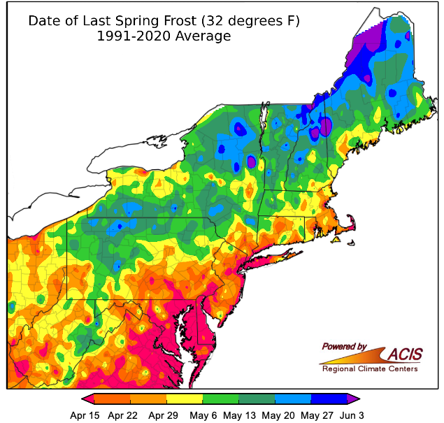
We’re still a few weeks away from the average date for our last frost. Image provided by the Northeast Regional Climate Center.

Thursday night: Showers, possibly a thunderstorm, ending after midnight. Some clearing toward daybreak. Low 39-46.

Friday: Mostly sunny and mild. High 61-68.

Friday night: Clear during the evening, then clouds stream back in overnight. Low 45-52.

Saturday: Mostly cloudy, showers develop during the afternoon. High 60-67.

Saturday night: Showers ending by midnight, some late-night clearing. Low 34-41.

Sunday: Mostly sunny and cooler. High 48-55.

Sunday night: Clear skies. Low 32-39.

Monday: Some morning sun, then clouds return during the afternoon. High 52-59.