Who’s ready for a nice quiet weekend weatherwise? Might I suggest a trip to Los Angeles then, because you’re not going to get one here, with or without Henri.
The remains of Tropical Storm Fred will continue to pull away this evening, but a few showers are still possible, otherwise, we’ll start to dry out a little overnight. However, warm and humid conditions will remain in place on Friday, with plenty of clouds and some sunny breaks, and possibly a few showers or thunderstorms. Saturday looks to be similar with some sunshine, but also some showers and thunderstorms possible as a warm and humid airmass remains in place. This brings us to Sunday and Monday, which is entirely dependent on the track of Henri.

As of 11am Thursday, Tropical Storm Henri was centered about 810 miles south of Nantucket, moving toward the west at 10 mph. Maximum sustained winds were near 70 mph. An Air Force Reconnaissance aircraft is investigating the storm right now to assess the true strength and structure of it. This should help improve the forecasts for the storm. Henri is fighting off some northerly wind shear as it moves around the edge of a ridge of high pressure, which is preventing it from strengthening. As it reaches the edge of the ridge tomorrow, it should turn more northward, and the shear will lessen. Combined with the fact that it will be over the warm waters of the Gulf Stream means that it should strengthen into a hurricane. As the same time, an upper-level low pressure area will develop over the Great Lakes, helping to steer Henri northward as well. This is where the largest uncertainty comes into play, and it has a giant impact on the forecast. Does the combination of the low to the west and ridge to the east remain strong and keeping Henri on a northward track, or does the ridge weaken a bit and allow Henri to turn more toward the northeast? If that wasn’t enough to complicate things, we also need to see how fast Henri is traveling at that point. The water off the Northeast coast is not warm enough to sustain a tropical system, so it will start to weaken. The faster it is moving, the less time it will have to weaken before reaching our latitude. These are questions that we can’t answer yet.
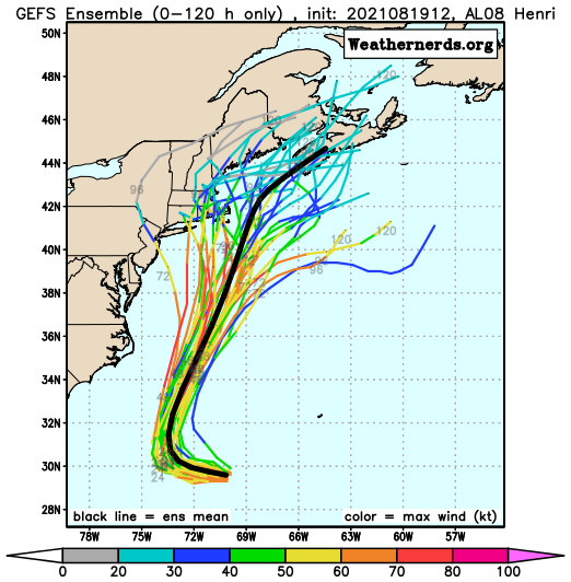
Since Henri formed, our thinking all along has been that it would pass close to or just south and east of Cape Cod, close enough for some impact across the Cape and Islands at least. That remains a plausible scenario. There are plenty of models that have landfall across Rhode Island or Southeastern Massachusetts as either a hurricane or strong tropical storm, and others that show no landfall and keep the storm offshore. Either way, it’s important to remember that as storms reach this latitude, they become lopsided, with most of the heavy rain to the left of the center, and the stronger winds confined to the right of the center. So, a track near or just off the Cape would spare most of the region from the strong winds, but result in heavy rainfall, especially across eastern Massachusetts. A track across southeastern Massachusetts would bring strong winds onto the Cape and Islands, and shift the heavy rain inland a bit more. The track will also impact the storm surge. With a full moon on Sunday, we’re already going to have astronomical high tides, which can create some coastal flooding on their own in spots. Add in a storm surge, and significant coastal flooding is likely, especially just to the right of the storm track. With all of these things possible, the National Hurricane Center will likely issue a Tropical Storm or Hurricane Watch for parts of the region on Friday.

Most of the impacts from Henri are likely from Sunday afternoon into Monday morning, but again, this is dependent on the track and speed of the storm. Either way, conditions should start to improve Monday afternoon as Henri begins to pull away.
Thursday night: Partly to mostly cloudy, a few showers possible during the evening. Low 66-73.
Friday: Intervals of clouds and sunshine, chance for a shower or thunderstorm. High 79-86. Offshore: Southwest 10-15 knots, gusts to 20 knots seas 3-5 feet.
Friday night: Partly cloudy, patchy fog may develop. Low 66-73.
Saturday: Partly sunny, a few showers and thunderstorms are possible in the afternoon. High 81-88. Offshore: Southeast 5-10 knots, seas 2-4 feet.
Saturday night: Mostly cloudy. Low 65-72.
Sunday: Cloudy and becoming breezy with some showers developing, possibly becoming a steadier and heavier rain late in the day. High 72-79. Offshore: Tropical storm conditions likely
Sunday night: Breezy to perhaps windy with rain, possibly heavy. Low 62-69.
Monday: Diminishing winds with rain tapering off to showers and ending, some sunny breaks may develop in the afternoon. High 74-81. Offshore: Tropical storm conditions likely, subsiding late in the day.
