Hurricane Henri continues to move up the East Coast with eastern Long Island or Rhode Island apparently in its sights for Sunday.

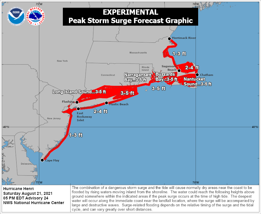
Henri strengthened into a hurricane this morning with maximum sustained winds near 75 mph. As of 5pm it was centered about 335 miles south of Montauk Point, Long Island, moving toward the north-northeast at 18 mph. A hurricane warning is in effect across central and eastern Long Island, and along the south coast of New England from New Haven, CT to Westport, MA, including Block Island. A Tropical Storm Warning is in effect west of New Haven to Manasquan Inlet, NJ, including western Long Island and New York City. A Tropical Storm Warning is also in effect east of Westport, MA to Chatham, MA, including Nantucket and Martha’s Vineyard. A Storm Surge Warning in effect from Flushing, NY to Chatham, MA, including most of Long Island, Block Island, Martha’s Vineyard, and Nantucket.

There is a little more confidence in the forecast this afternoon, but still some some uncertainty. Henri is being steered north-northeastward by a ridge of high pressure to its east and a developing upper-level low over the Mid-Atlantic states. With less wind shear and warmer waters beneath it, Henri may strengthen a bit more over the next 6-12 hours while continuing northward. At that point, the question becomes – does Henri feel the influence of the upper-level low and bend northwestward, or does it continue off to the north? This will have significant implications to where it makes landfall and what conditions we can expect across the region. The current forecast from the National Hurricane Center has landfall Sunday afternoon near Montauk just below hurricane strength. The forecast models have shifted eastward a bit today, showing landfall anywhere from Central Long Island to as far east as Cape Cod. However, over the past 18 hours, the forecast models have trended a bit more to the east. Right now, our thinking is that landfall will be somewhere between extreme eastern Long Island and Narragansett Bay Sunday afternoon. With Henri weakening over colder waters as it approaches the coast, it will likely be a strong tropical storm at landfall, though there is a chance it could still be a minimal hurricane.

Once inland, Henri will rapidly weaken, but the track still will have an impact on the forecast. If it turns northwest, it will eventually stall out and then head eastward, but this will prolong the rainfall across the region, especially north and west of the track. Much of the region has received very heavy rain over the past 2 months. This has saturated the soil. As a result, some trees may be more susceptible than usual to winds of this strength, which may result in more widespread wind damage. The heavy rains will also lead to flooding, especially from western New England into parts of southeastern New York and Long Island.

To the east of the track, rainfall will just be spotty, with some gusty winds, mainly confined to coastal areas, where some gusts of 40-50 mph are possible. This is also where a storm surge of 3-5 feet on top of astronomical high tides will result in some coastal flooding, especially in parts of Rhode Island and southeastern Massachusetts. East of the track is also where we will need to keep an eye out for some short-lived tornadoes. Many landfalling tropical cyclones produce small tornadoes in the right-front quadrant of the storm. For a northward-moving storm like this, that means areas north and east of the center.
Once Henri dissipates, the Atlantic looks a bit more quiet for now. However, we’re approaching the peak of hurricane season, so the quiet period likely won’t last that long.
