What’s left of Tropical Storm Fred is dumping heavy rain on parts of the Mid-Atlantic states this afternoon, but there are still two active tropical systems in the Atlantic, and both could cause significant problems.

Hurricane Grace is the more immediate threat. As of early Wednesday afternoon, Grace was centered about 295 miles east of Tulum, Mexico, moving toward the west-northwest at 15 mph. Maximum sustained winds were near 75 mph. A Hurricane Warning is in effect for eastern portions of the Yucatan Peninsula, with a Tropical Storm Warning for other portions of the Yucatan as well as the Cayman Islands.
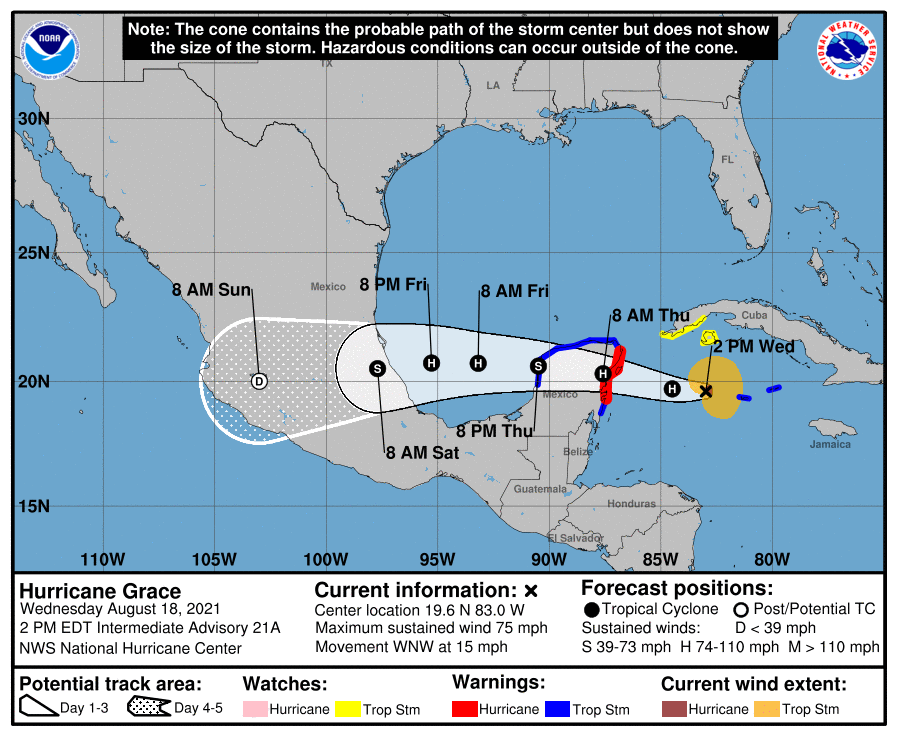
Grace’s forecast is fairly straightforward. It should strengthen a bit more today and tonight before making landfall in the Yucatan early Thursday. It should weaken a bit over land, then move back into the Bay of Campeche late Thursday. It will likely strengthen again, likely regaining hurricane status before a second landfall in Mexico late Friday or early Saturday between Veracruz and Tampico. Strong winds, torrential rainfall that will lead to flooding and mudslides, and storm surge flooding are all expected across the region.

Grace produced heavy rain and flooding over the past several days from the Leeward Islands across Puerto Rico and the Virgin Islands, into Hispaniola, Jamaica, the Cayman Islands, and parts of Cuba. Rainfall totals of up to 10 inches were observed in some areas. While winds haven’t been a huge factor thus far for much of the region, wind gusts exceeded 50 mph on Jamaica, with some gusts to near hurricane force reported in the Cayman Islands this morning as Grace pulled away.
While Grace is preparing to slam into the Yucatan, all eyes here in New England are focused on Tropical Storm Henri. As of early Wednesday afternoon, Henri was centered about 190 miles southwest of Bermuda, or 795 miles south-southeast of Nantucket, moving toward the west at 8 mph. Maximum sustained winds were near 65 mph. Some slow strengthening is expected, and Henri could become a hurricane over the next few days.
Henri’s future track is highly uncertain at this point. With a ridge of high pressure to the north and east, it should continue westward for the next day or so before it reaches the western edge of the ridge and begins to turn northward. At the same time, an upper-level low pressure area will begin to develop over the Great Lakes. These two features will combine to send Henri up the East Coast, but that’s where the uncertainty really begins. Some models have Henri continue moving around the ridge and turning northeastward, either heading out to sea or possibly impacting parts of Atlantic Canada. Some models have the upper low strengthen a bit more and the ridge build back in, allowing Henri to keep heading north, possibly even turning toward the northwest like Sandy did, which would result in landfall across New England or Long Island. Given that this is still around 4 days or so away from any potential impact, it is just too early to tell which scenario is more likely. Either way, residents of Southern New England should keep a close eye on Henri’s progress.

With the forecast as it is, and knowing how the media can be, we are issuing an Extreme Hype Watch for the region. An Extreme Hype Watch is issued when conditions are favorable for media hype of an event to reach extreme levels within the next 48-72 hours. If conditions warrant, a Hype Advisory or Extreme Hype Warning will be issued as the event draws nearer.
Tomorrow marks 30 years since Hurricane Bob made landfall near Newport, Rhode Island. The 30 years is the 2nd longest we’ve ever gone without a hurricane landfall in New England or Long Island.
- Since 1851, a hurricane has made landfall in New England or Long Island 18 times, an average of one every 9.4 years. The longest we’ve ever gone between hurricane landfalls is 38 years, between 1896 and 1934. It’s been 30 years since Bob, our 2nd longest drought on record. (Of the 18 hurricanes that made landfall in New England or Long Island since 1851, 15 of them have done so between August 19 and September 27.)
- Since 1851, 9 hurricanes of Category 2 intensity or stronger have made landfall in New England or Long Island, an average of one every 18.9 years. The longest we’ve gone between hits by storms of that intensity is 69 years, between 1869 and 1938. We’re at 30 years since Bob, the last one to do so.
- Since 1851, New England/Long Island has had 3 Major Hurricanes (Category 3 or higher) make landfall – an unnamed storm in October of 1869, the infamous 1938 Long Island Express, and Hurricane Carol in 1954. That’s an average of 1 every 56.7 years, and the longest time between 2 major hurricanes is 69 years (1869-1938). We’re at 67 years since Carol. There are also 3 documented storms from before 1851 – The Great Colonial Hurricane of 1635, the 1815 New England Hurricane, and the Norfolk and Long Island Hurricane of 1821. That’s it. That changes the numbers to 6 in 386 years, or one every 64.3 years, with a longest drought of 180 years.

There is some history involving New England and the two current names, Grace and Henri. In 1991, Grace was a hurricane off the East Coast in late September. As it moved northward, it was absorbed by a much larger extratropical system which eventually started moving south and then southwest off the coast of New England. This became the “No-Name Halloween Storm”, or as the book and movie were later titled – ‘The Perfect Storm”. Grace was a new addition to the name list in 1991, as the previous “G” storm had its name retired. That storm was Gloria in 1985, which slammed into Long Island on September 27. As for Henri, it also hit New England in 1985, a few days before Gloria. Most people don’t remember it for two reasons. First, it was very weak – it weakened to a tropical depression right at landfall near Westerly, Rhode Island on September 24 and rapidly dissipated. It did not produce much rain or wind across the region. Second, all eyes were on the much more powerful Hurricane Gloria which was starting to move up the East Coast
