Drier and warmer weather is expected as we head through much of the upcoming weekend.
High temperatures are generally in the lower to middle 80s around here in mid-July. Image provided by weathermodels.com
The last of the rain that brought flooding to the southern suburbs of Boston this morning will move offshore this evening, then high pressure builds in north of the area. This will result in drier weather for the next few days, with temperatures near or a little below normal, especially at the coast, thanks to onshore winds. There is still a chance for a few widely scattered pop-up showers and thunderstorms each afternoon, especially on Friday, but these will be confined to the interior, and the vast majority of the region won’t see any at all. Temperatures will rise a little on Monday as will humidity levels, making it a bit more uncomfortable than the previous few days. We’ll also see a cold front starting to approach on Monday, and this will give us a better chance for more widespread showers and thunderstorms during the afternoon and evening.
Showers and thunderstorms could be moving into the region later on Monday. Images provided by Pivotal Weather.
Thursday night: Any lingering showers end in the evening, mostly cloudy with areas of fog overnight. Low 59-66.
Friday: Morning clouds, then becoming partly sunny, slight chance for an afternoon shower or thunderstorm, mainly across the interior. High 78-85, a little cooler at the coast.
Friday night: Partly cloudy, patchy fog redevelops. Low 61-68.
Saturday: Partly sunny, a stray shower or thunderstorm possible across the interior during the afternoon. High 79-86, a little cooler at the coast.
Saturday night: Partly to mostly cloudy, more fog possible. Low 61-68.
Sunday: A mix of sun and clouds, just a very slight chance for a shower or thunderstorm. High 78-85, a little cooler across Cape Cod.
Sunday night: Partly to mostly cloudy. Low 61-68.
Monday: Intervals of clouds and sun, showers and thunderstorms may develop in the afternoon. High 79-86, a little cooler across Cape Cod.
Heat and humidity remain in place to start the week, but they won’t last too long.
The heat index will be in the lower to middle 90s again this afternoon. Image provided by WeatherBell.
High pressure sits offshore today while a cold front begins to approach from the west. That’s a recipe for hot and humid conditions across our region today. We could see a few showers and thunderstorms pop up during the afternoon, but they should not be widespread. Tuesday is the transition day, though it will be very warm to hot and quite humid once again. Across parts of southeastern Massachusetts and Cape Cod there is the potential for some heavy downpours early in the day as what’s left of Tropical Storm Chantal moves past the area. Later, that cold front will move across the region, resulting in more widespread showers and thunderstorms, a few of which could be strong to severe across the interior.
A few showers and storms are possible today, but they are more likely late Tuesday into Tuesday evening. Loop provided by Weathermodels.com
The front settles south of the region, but likely remains close enough for plenty of clouds on Wednesday with cooler temperatures and possibly a few showers as well. A wave of low pressure riding along the front brings in more showers for Thursday. For Friday, a few lingering showers are possible, but some drier air will start to move in as high pressure starts to build in across southeastern Canada. Saturday should be mostly dry, but with an upper level low pressure area moving through we’ll see some clouds and possibly a shower or two in the afternoon. High pressure should move offshore for Sunday with dry and warmer weather expected.
A few models show the potential for heavy rain near the South Coast Thursday, but many show nothing more than scattered showers. Images provided by Pivotal Weather.
Monday: Partly sunny, breezy, quite humid, chance for a few showers or thunderstorms. High 85-92, a little cooler across the South Coast and Cape Cod.
Monday night: Partly to mostly cloudy with areas of fog, some rain possible across southeastern Massachusetts and Cape Cod after midnight. Low 67-74.
Tuesday: A mix of sun and clouds, humid, showers and thunderstorms likely in the afternoon, a few could be strong. High 85-92, cooler across Cape Cod.
Tuesday night: Mostly cloudy, showers and storms taper off fog redevelops. Low 64-71.
Wednesday: Partly to mostly cloudy, a shower or two is possible, cooler. High 75-82.
Wednesday night: Plenty of clouds, some showers possible after midnight, mainly near the South Coast. Low 61-68.
Thursday: Mostly cloudy with scattered showers. High 74-81.
Thursday night: Cloudy with more showers. Low 60-67.
Friday: Mostly cloudy, a few more showers, mainly in the morning, some sunny breaks possible in the afternoon. High 72-79.
Saturday: Becoming partly sunny, slight chance for a pop-up shower. High 75-82.
Sunday: Intervals of clouds and sunshine. High 77-84.
Some fantastic weather is on the way for the holiday weekend.
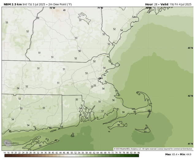
Dewpoints will drop into the 50s for the Fourth of July. Image provided by WeatherBell.
A cold front will cross the region this evening, bringing an end to the heat and humidity, and taking any lingering showers and thunderstorms offshore. High pressure then builds in for the Fourth of July with sunshine and a few clouds, much lower humidity, and seasonably warm temperatures. You won’t have any weather-related issues for outdoor activities during the day or at night. Saturday will be similar, perhaps a few degrees warmer, and maybe a touch more humid, but still very comfortable. For Sunday and Monday, the high will start to move offshore, so both temperatures and humidity will start to creep up, with temperatures above 90 in many areas.
Heat and humidity return on Sunday. Image provided by weathermodels.com
A cold front will also be starting to approach on Monday, so we’ll see clouds starting to move in, but it looks like any shower or thunderstorm activity associated with the front should hold off during the daylight hours. However, that’s not the only thing we’re keeping an eye on for Monday. There’s a cluster of showers and thunderstorms currently sitting off the Southeast coast along a decaying front. Forecast models show the potential for a little development this weekend and given NHC’s track record so far this year, it wouldn’t be a surprise it they decided to call it a Tropical Depression or even a Tropical Storm. It will bring some heavy rain and gusty winds to parts of the Carolinas this weekend before either dissipating or heading out to sea well south of New England. However, some of the moisture from that storm will move up the East Coast. If it does, it will interact with the aforementioned cold front coming through here on Tuesday, but some models show the potential for it to get up here as soon as Monday afternoon or evening. We’re not convinced that will be the case just yet, but we’re not ruling it out either. We’ll have more on that in our Weekly Outlook early Monday morning, and potentially in a special blog post this weekend if the system does develop.
Will a system to the south send in some rain late Monday? It’s a possibility. Images provided by Pivotal Weather.
Thursday night: Any lingering showers or thunderstorms end in the evening, clearing overnight. Low 58-65.
Friday: Sunshine and a few clouds, much less humid. High 76-83.
Friday night: Clear during the evening, becoming partly cloudy late at night. Low 54-61.
Saturday: A mix of sun and clouds. High 79-86.
Saturday night: Partly cloudy. Low 62-69.
Sunday: Partly to mostly sunny, breezy in the afternoon, becoming humid. High 87-94, cooler along the South Coast and across Cape Cod.
Sunday night: Clear to partly cloudy. Low 66-73.
Monday: A mix of sun and clouds, breezy, chance for a late-day shower or thunderstorm, humid. High 88-95, cooler along the South Coast and across Cape Cod.
As we reach the halfway point of the year, we also have Canada Day and Independence Day this week, so whichever you celebrate, enjoy as we’ll have some typical summertime weather for much of the upcoming week.
Canada and the United States will both be celebrating birthdays this week.
We start the week off with high pressure offshore resulting in a very warm to hot day today with increasing humidity levels as winds shift into the southwest. Tuesday looks like another warm and very humid day with dewpoints getting well into the 70s, but with an approaching cold front, we’ll see clouds and probably two rounds of showers and thunderstorms. The first batch likely moves through during the morning hours, but it’s the second batch that we’re keeping an eye on. The potential exists for some of the storms to become strong to severe, but that will depend on several factors. If we can get any sunshine after the first batch of storms, it will help to destabilize the atmosphere, whereas if it stays cloudy and thus cooler, the cold front will just produce some showers with only a few rumbles of thunder. We are expecting some sunshine to develop, so the other important factor is the timing of the front. A front that arrives late afternoon, during the maximum heating of the day will be more likely to produce severe weather than a front that arrives during the evening, when we are past the max heating of the day. Any storms that do form could produce heavy downpours and strong winds.
We’re looking at two rounds of thunderstorms on Tuesday. Loop provided by Weathermodels.com
Behind the front, high pressure builds back in with drier and more seasonable conditions for Wednesday and Thursday as highs will be mainly in the 80s, with dewpoints dropping into the 50s and lower 60s. Another disturbance may trigger a few showers and thunderstorms late Thursday, but high pressure returns for the Fourth of July and into Saturday with some spectacular summer weather, which shouldn’t cause any problems for any outdoor holiday celebrations. Another system could move in for Sunday, but that’s far from certain at this point.
Right now the weather for the Fourth looks picture perfect. Image provided by WeatherBell.
Monday: Some morning fog, otherwise partly to mostly sunny, humid. High 84-91, cooler along the coast and across Cape Cod.
Monday night: Becoming partly to mostly cloudy with fog redeveloping, especially along the coast. Some showers and thunderstorms are possible towards daybreak. Low 63-70.
Tuesday: Some showers and thunderstorms possible early, then intervals of clouds and sunshine, showers and thunderstorms may redevelop late in the day, breezy, very humid. High 82-89, cooler across the South Coast and Cape Cod.
Tuesday night: Showers and thunderstorms ending, some clearing after midnight. Low 64-71.
Wednesday: Becoming mostly sunny, less humid. High 81-88.
Wednesday night: Clear skies. Low 61-68.
Thursday: Sunshine and some afternoon clouds, chance for a late-day shower or thunderstorm. High 83-90, cooler across Cape Cod.
Thursday night: Chance for a shower or thunderstorm in the evening, otherwise becoming clear to partly cloudy. Low 59-66.
Friday: Mostly sunny, drier. High 76-83.
Saturday: A mix of sun and clouds. High 79-86.
Sunday: Partly sunny, more humid, breezy, chance for a few showers or thunderstorms. High 86-93, cooler across Cape Cod.
The heat and humidity are gone, with cool and damp weather return, the hot and humid weather could make a return by the end of the weekend.
Temperatures are 20-30 degrees colder this afternoon than they were at this time yesterday. Image provided by Weathermodels.com
The front that ended the heat wave moved through yesterday and has settled offshore, with high pressure building in to the north. This has shifted winds into the east and northeast, bringing much cooler air in, and it will hang around into Friday. As disturbances ride along the front, we’ll have episodes of showers into Saturday, though the vast majority of the time will remain dry. As the high slides offshore, winds will start to shift into south and southwest on Saturday, allowing temperatures to warm into the 70s in many areas, especially south of the Mass Pike, though we’ll still have plenty of clouds and a few showers, especially north of the Mass Pike, but dewpoints will climb back into the 60s, perhaps even lower 70s across the region. We should see a little more in the way of sunshine on Sunday, allowing temperatures to get back into the 80s in many areas. By Monday, the very warm and humid weather will return, with highs well into the 80s and dewpoints in the 60s and lower 70s across much of the region resulting in another moderately uncomfortable day.
Most (but not all) of the models show drier weather moving in Saturday afternoon. Images provided by Pivotal Weather,
Thursday night: Plenty of clouds with a few showers possible. Low 56-63.
Friday: Intervals of clouds and sunshine, slight chance for a shower. High 66-73.
Friday night: Mostly cloudy with some showers likely. Low 55-62.
Saturday: Mostly cloudy with a chance for more showers, mainly in the morning. High 73-80 south of the Mass Pike, 65-72 north of the Pike.
Saturday night: More clouds with a few more showers possible. Low 60-67.
Sunday: Becoming partly sunny. High 75-82.
Sunday night: Partly cloudy. Low 58-66.
Monday: A mix of sun and clouds. High 81-88, cooler across Cape Cod.
The first half of the week is looking quite toasty, but the second half looks quite unsettled. There’s also the chance the first tropical depression of the season in the Atlantic could develop.
A large ridge of high pressure will bring heat and humidity to much of the East to start the week. Image provided by Pivotal Weather.
A ridge of high pressure will remain in place across the Eastern US to start the week, resulting in some very warm to hot and humid conditions. Temperatures will soar well into the 90s in many areas today with sunny skies, but a seabreeze will keep coastal areas a little cooler, mainly in the 80s. When you factor in dewpoints in the upper 60s and 70s, it’s going to feel like it is over 100 degrees outside, away from the coastline. Temperatures only drop into the 70s at night, setting us a brutally hot and humid day on Tuesday. Temperatures should be well into the 90s across much of the region, and it isn’t out of the question that a few places get close to 100 degrees. Again, with the humidity factored in, it will feel likely 100 to 110 once again. Wednesday is the transition day, as a weak backdoor cold front begins to drop down from the north. Inland areas will still be hot, likely topping 90 once again, but coastal areas may stay in the 80s as winds become onshore. A few showers or thunderstorms may accompany the front, bringing some relief from the heat.
The heat index will be over 100 across much of the region Tuesday afternoon. Image provided by WeatherBell.
That front should settle off to the south later Wednesday before stalling out, bringing an end to the heat and allowing much cooler air to settle into the region. As weak disturbances ride along the front, we’ll have episodes of showers and times between Thursday and Sunday. None of the days should be a washout, but it will definitely be cooler and wetter than the first half of the week, with temperatures likely below normal for the end of June. Sunday may actually turn out to be a decent day, with a lesser chance for showers and the potential for some milder temperatures.
The latter half of the week and the weekend will feature below normal temperatures. Image provided by weathermodels.com
Monday: Sunshine and a few clouds. High 90-97 inland, 82-89 along the coast, a little cooler across the Outer Cape.
Monday night: Mostly clear, a little patchy fog possible near the South Coast and Cape Cod. Low 69-76, a little cooler across Cape Cod.
Tuesday: Sunny, hot, and humid, just a slight chance for a late-day shower or thunderstorm. High 93-100, cooler across Cape Cod and the immediate South Coast.
Tuesday night: Clear skies. Low 71-78, cooler across Cape Cod.
Wednesday: A mix of sun and clouds, slight chance for a shower. High 87-94, cooler along the immediate coast and across Cape Cod.
Wednesday night: Becoming partly to mostly cloudy, chance for a few showers. Low 62-69.
Thursday: More clouds than sunshine with some showers possible. High 71-78.
Thursday night: Partly to mostly cloudy, chance for a shower. Low 57-64.
Friday: Mostly cloudy with some showers likely. High 68-75.
Saturday: Plenty of clouds, chance for more showers. High 71-78.
Sunday: Partly sunny, slight chance for a shower. High 75-82.
Meanwhile, in the tropics, there is the chance that our first tropical depression of the season could be forming. A weak area of low pressure has developed a few hundred miles east of Bermuda. It is generating some thunderstorms, and conditions are marginally favorable for a little development today, then conditions become a little more hostile after that. Given that we are past the average date of the first tropical storm in the Atlantic (June 20), and there hasn’t been anything even resembling an organized system yet, the folks at the National Hurricane Center are probably bouncing off the walls with nothing to do, so they’ll probably end up naming this, even though it’s not purely tropical and won’t be around for more than 12-24 hours.
Low pressure east of Bermuda is being monitored for development. Loop provided by Tropical Tidbits.
We’ve got a fairly complicated forecast for the final days of Spring and initial days of Summer.
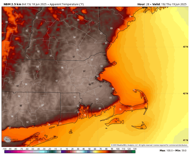
The heat index will reach the middle to upper 90s across much of the region on Thursday. Image provided by WeatherBell.
A warm and humid airmass has settled into the region, and it will be here into Thursday. We’ll have plenty of clouds through the evening with a few showers and possibly a rumble of thunder as a weak disturbance moves across the region. These showers should end before midnight, then we’ll see some fog developing. Once the fog burns off Thursday morning a hot and humid day is expected under partly to mostly sunny skies. Gusty southwest winds will help send temperatures into the upper 80s and lower 90s in much of the region, except along the South Coast and Cape Cod, where winds off the water will keep temperatures a little cooler. Dewpoints well get into the 60s and lower 70s, resulting in the heat index reaching the middle to upper 90s in many areas. A Heat Advisory has been issued for parts of the region as a result.
Severe weather is possible in the Northeast Thursday with damaging winds the greatest threat. Image provided by Pivotal Weather.
A cold front will move across the region late in the day, triggering some showers and thunderstorms during the late afternoon and evening. A few of these storms may produce strong winds, heavy downpours and some hail, but it looks like the best chance for severe storms will be off to our west. If the front were to move in a little faster than we currently expect, the odds for severe weather would rise, since it would be arriving around the time of maximum heating. Behind the front, drier air settles in for Friday, and while it won’t be as hot, it will still be quite warm. As we get to Saturday, it looks like we will finally break our streak of wet Saturdays with sunshine, mild temperatures, and lower humidity, but that doesn’t mean the entire weekend will be dry.
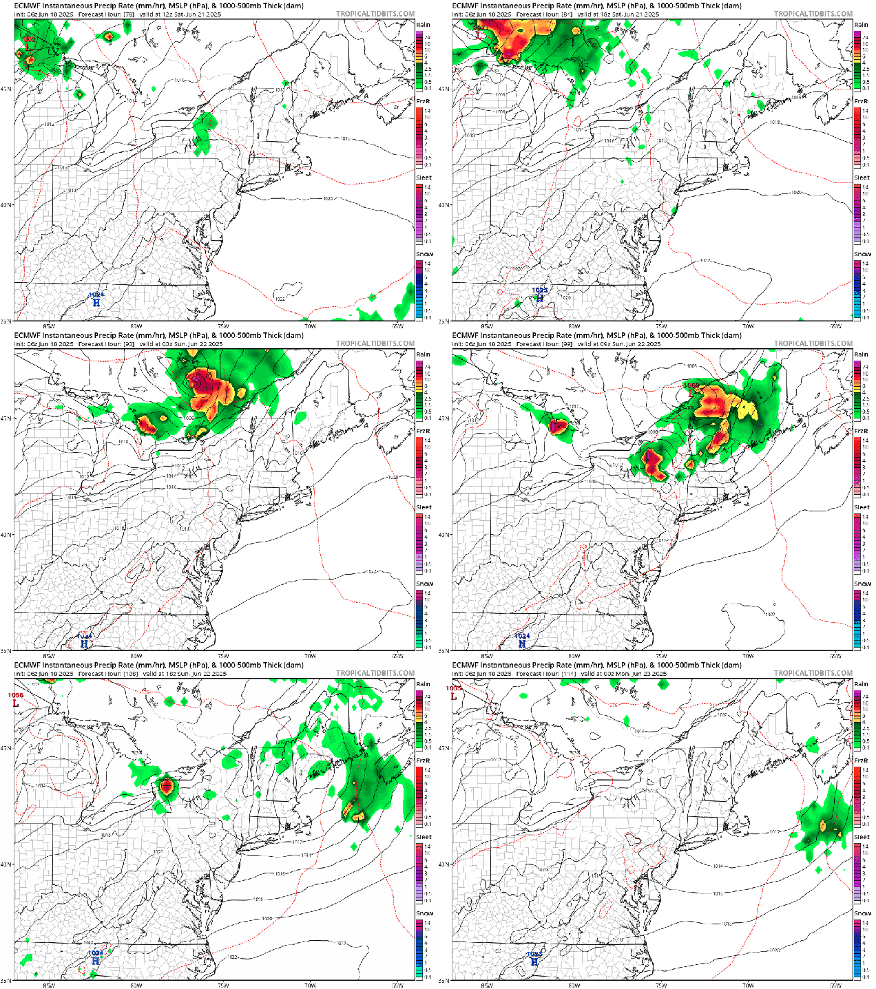
A cluster of thunderstorms could rumble across the region before daybreak Sunday, Loop provided by Tropical Tidbits.
Forecast models have been showing the potential for a cluster of potent thunderstorms to develop across the Northern Plains Friday evening which would then race across the Northern Great Lakes on Saturday before diving into New England after midnight Saturday night. While they should be weakening by the time they get here, don’t be surprised if you’re awakened early Sunday morning by frequent lightning and some heavy downpours. Once those storms move offshore, skies will become partly to mostly sunny again with another dry and warm day expected. Things change again by Monday. A ridge of high pressure will start to build in, resulting in heat and humidity returning on Monday, and possibly for at least a few more days beyond that heading into next week. We’ll have more on that in our Weekly Outlook early Monday morning.
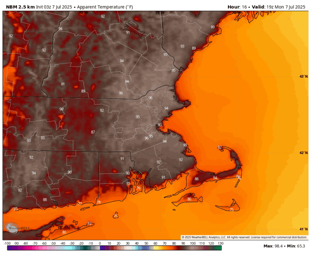
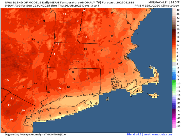
The first half of next week could be quite toasty around here. Image provided by weathermodels.com
Wednesday night: Partly to mostly cloudy, chance for a few showers during the evening, areas of fog develop overnight, muggy. Low 61-68.
Thursday: Becoming mostly sunny, hot, and humid, showers and thunderstorms possible late in the day, breezy. High 87-94, cooler along the South Coast and across Cape Cod.
Thursday night: Showers and thunderstorms expected during the evening, clearing overnight, breezy. Low 61-68.
Friday: Sunshine and a few clouds, not as humid, still breezy. High 76-83.
Friday night: Clear to partly cloudy. Low 58-65.
Saturday: Sunshine with some afternoon clouds. High 80-87, cooler across Cape Cod.
Saturday night: Partly to mostly cloudy, showers and thunderstorms possible after midnight. Low 61-68.
Sunday: Showers and storms end early, then a mix of sun and clouds. High 81-88, cooler across Cape Cod.
Sunday night: Partly cloudy. Low 63-70.
Monday: Partly to mostly sunny, hot, and humid. High 87-94, cooler along the South Coast and across Cape Cod.
Astronomical summer begins Friday night (10:41pm EDT to be exact), but we’re going to have some summer weather for a good portion of the upcoming week.
Temperatures could reach 90 in some spots on Thursday. Image provided by WeatherBell.
We’re starting the week off with high pressure in control, keeping us dry, but temperatures will remain a little below normal for mid-June, but changes are coming. Low pressure heading into southern Canada will send a warm front our way on Tuesday, but it likely doesn’t arrive until nighttime, keeping us on the cool side once again. There could be a few showers ahead of a warm front, but most of us should stay dry. The warm front moves through, setting up a much warmer and more humid day on Wednesday. Again, there is a chance for a few widely scattered showers or thunderstorms, but they shouldn’t be that common. Thursday, however, could be an interesting day weather-wise. A cold front will be approaching the region from the west. Ahead of it, it will be a very warm and humid day, and with the approaching front, some showers and thunderstorms are likely. There are several factors we need to pay attention to, the biggest one being the timing of the front, but the potential exists for some strong to severe storms. We’ll keep an eye on this, and will post an update on Wednesday if severe weather looks more likely. Behind the front, dry and somewhat cooler air settles in for Friday, though an upper-level disturbance moving through could trigger another pop-up shower or two. This brings us to Saturday, and for the first time in a while, it looks like it will be dry. There’s plenty of time for things to change, but our stretch of wet Saturdays *could* be ending this week. Another weak system may bring in a few showers or thunderstorms on Sunday.
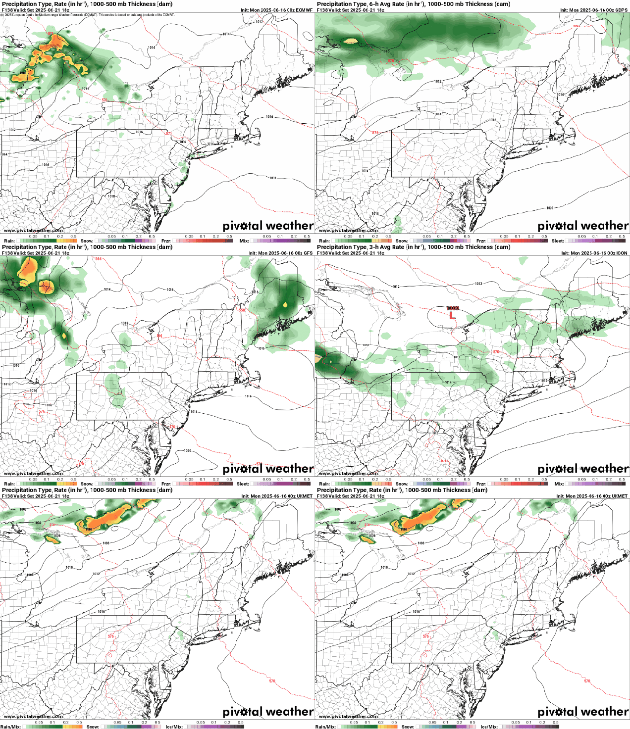
For now, the models are indicating that Saturday may stay dry around here. Images provided by Pivotal Weather,
Monday: Intervals of clouds and sun. High 69-76, coolest along the coast.
Monday night: Partly to mostly cloudy, slight chance for a shower, patchy fog may develop. Low 53-60.
Tuesday: More clouds than sun, chance for a few showers. High 68-75, coolest along the coast.
Tuesday night: Mostly cloudy with a few showers, mainly during the evening, fog may redevelop. Low 56-63.
Wednesday: Becoming partly sunny, a shower is possible. High 76-83, a little cooler across the South Coast and Cape Cod.
Wednesday night: Partly cloudy, patchy fog possible. Low 62-69.
Thursday: A mix of sun and clouds, showers and thunderstorms likely in the afternoon, breezy. High 84-91, cooler along the South Coast and Cape Cod.
Thursday night: Showers and storms ending in the evening, then becoming clear. Low 61-68.
Friday: Sunshine and some afternoon clouds, slight chance for a shower. High 77-84.
Saturday: Partly to mostly sunny. High 77-84.
Sunday: Partly sunny, chance for a shower or thunderstorm. High 81-88, cooler across the South Coast and Cape Cod.
The calendar says it’s mid-June, but the forecast feels like Groundhog Day, because for the 13th week in a row, we’re here to tell you that it’s going to rain on Saturday.
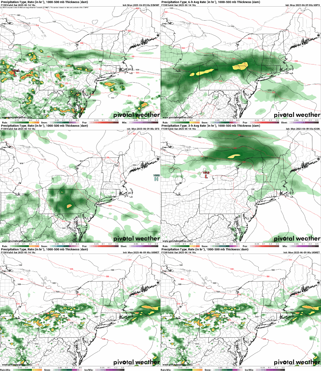
No matter which model you look at, they all have rain for at least part of the region Saturday morning. Images provided by Pivotal Weather.
After a warm day today we have a cold front moving through with just some clouds and possibly a stray shower through the evening. That front will settle just offshore and stall out, with cooler weather filtering in behind it for Friday, with temperatures running 10-15 degrees cooler than today, close to or a little below where we should be in mid-June. Friday should be dry, with sunshine filtered through some high clouds. A weak area of low pressure will ride along the front Friday night and early Saturday, bringing some rain into the region along with rather cool conditions. The rain should taper off during the morning, but east winds off the Atlantic will keep clouds in place Saturday afternoon with a little drizzle at times, and temperatures only in the 60s, possibly upper 50s near the coast. For Sunday and Monday, we’ll be stuck in between high pressure to the north and another weak low pressure system riding along that front to our south. The result will be plenty of clouds, possibly a few showers, and temperatures remaining on the cool side, though Monday will likely be a little milder. The good news is that temperatures should warm up quite a bit as we get towards the middle of next week.
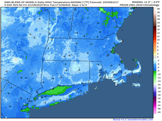
Temperatures will be cooler than normal for the next few days. Image provided by weathermodels.com
Thursday night: Slight chance for a shower near the South Coast during the evening, otherwise clear to partly cloudy with increasing clouds late at night. Low 55-62.
Friday: A mix of sun and clouds. High 72-79, a little cooler across Cape Cod.
We’ve got a fairly typical week of weather for mid-June coming up across the region.
Thursday looks like the warmest day this week with many locations likely getting well into the 80s. Image provided by WeatherBell.
We start the week off on a cloudy and cool note with a warm front off to our south and a weak upper-level disturbance moving through, possibly producing a few widely scattered showers. The warm front moves through late tonight and early Tuesday as low pressure passes north and west of the region. This will result in a warmer and more humid day, with some showers and thunderstorms expected ahead of a cold front trailing that low pressure system. Behind that front high pressure builds in with warmer and drier weather for Wednesday and Thursday with temperatures well into the 70s, with some 80s, especially on Thursday. Although we’ll have sunshine, smoke from Canadian wildfires may result in hazy skies both days, and my keep temperatures a little lower than we are currently expecting.
Smoke from Canadian wildfires will impact much of the Northeast on Wednesday. Image provided by NASA.
The end of the week is a lot more uncertain at this point. We’ll have a big high pressure area across southeastern Canada, and a frontal system stalled out south of New England, with waves of low pressure riding along it. Where that front stalls out and has the waves move through determines when (or if), we get any rain (and how much) next weekend. Friday should be a mostly dry day with the front moving through, though there could be a few showers accompanying it. It’s the weekend that has the most uncertainty. Some models keep Saturday dry, some have some showers, some heave steadier rain especially late in the day. Sunday is fairly similar, with some models showing a decent amount of rain, some having just some showers, and some keeping us mostly dry. Temperatures will also be dependent on the position of the front and waves riding along it, along with the timing and amount of any rainfall. Don’t go cancelling any weekend plans just yet as it’s still several days away and there’s a lot of uncertainty, but have a backup plan ready just in case.
Are we in for yet another rainy Saturday? It remains to be seen. Images provided by Pivotal Weather.
Monday: Areas of morning fog, otherwise mostly cloudy with a few showers possible. High 63-70, coolest along the coast.
Monday night: Overcast with a few showers and some dense fog possible. Low 53-60.
Tuesday: Plenty of clouds with showers and some thunderstorms. High 67-74.
Tuesday night: Showers end in the evening followed by clearing after midnight. Low 55-62.
Wednesday: Plenty of sunshine, breezy. High 76-83, a little cooler across Cape Cod.
Wednesday night: Mostly clear. Low 60-67.
Thursday: Sunshine and some afternoon clouds, breezy. High 78-85, a little cooler across Cape Cod.
Thursday night: Partly to mostly cloudy. Low 56-63.
Friday: Intervals of clouds and sun. High 72-79.
Saturday: Mostly cloudy with some showers possible. High 65-72.
Sunday: More clouds than sun with a chance for more showers. High 65-72.