Weekly Outlook: July 31 – August 6, 2017

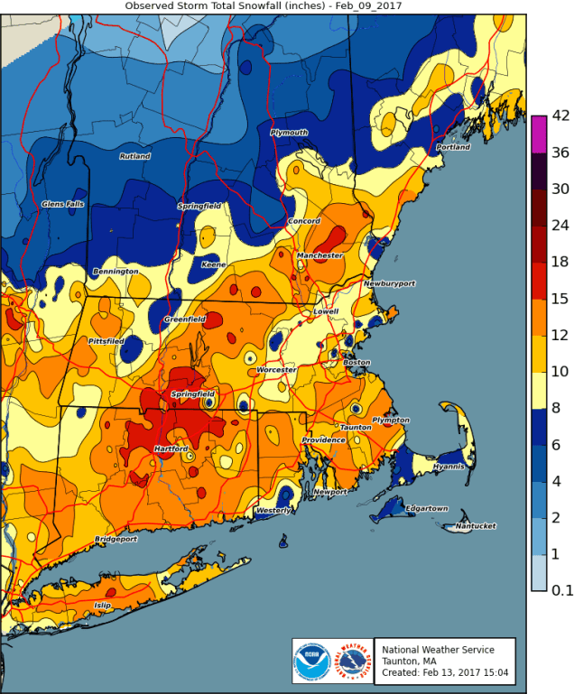
Let’s turn the clock back about 6 months, to February 9, 2017. Do you remember that day? Patrice Bergeron had 4 points and the Bruins beat San Jose 6-3 in Bruce Cassidy’s first game as the new Bruins head coach. The Celtics beat the Portland Trailblazers 120-111, led by Isaiah Thomas scoring 34 points. Of course, we were also just four days removed from the greatest comeback in Super Bowl history. Do you remember anything else about that day? No? Nothing? Let us refresh your memory:
Feb_09_2017_Snow_Anal_exp
Snowfall totals from February 9,2017. Image provided by the National Weather Service Office in Taunton, MA


Yeah, you remember now, don’t you? You were trying to block it out and we just brought it back. It was in the 20s and lower 30s for temperatures, and snowed heavily for much of the day. As you can see from the map above, many of us were shoveling somewhere in the vicinity of a foot of snow that day. So, why are we bringing this up now? We’re betting that on that day, you were probably thinking about a nice week of vacation in the middle of the summer, with sunshine, warm temperatures, and no hint of any snow. Does this sound familiar? Well, that week you were dreaming of is here.

High pressure will be in control for much of the week. For the first half of the week, that means sunshine, warm temperatures, and low humidity. Temperatures and humidity levels will start to creep up as we head towards midweek, with the possibility of some afternoon showers and thunderstorms as we get later in the week. A cold front may bring in more showers and thunderstorms on Saturday, then high pressure returns for Sunday.

nam_dew2m_boston_7
Dewpoints in the upper 50s to lower 60s on the last day of July? We’ll take that without question. Image provided by WeatherBell.


Monday: Wall-to-wall sunshine with just a few afternoon clouds. High 81-88, a little cooler along the coast.

Monday night: Mostly clear. Low 59-66.

Tuesday: Partly to mostly sunny. High 83-90. a little cooler right along the coast.

Tuesday night: Clear to partly cloudy. Low 63-70.

Wednesday: A mix of sun and clouds, more humid, a shower or thunderstorm can’t be ruled out. High 83-90.

Thursday: Partly sunny, afternoon showers or thunderstorms are possible. High 83-90.

Friday: Sunshine and some afternoon clouds, breezy, slight chance for a shower or thunderstorm. High 81-88.

Saturday: More clouds than sunshine with scattered showers and thunderstorms. High 77-84.

Sunday: Partly to mostly sunny. High 77-84.

Finally, we’ll mention a couple of things about the tropics. There are still a few storms in the Pacific, and one area we’re watching in the Gulf of Mexico. First, we’ll talk about the Gulf, since it’s closer. There’s a cluster of thunderstorms off the west coast of Florida. It’s got a small window of opportunity to get its act together before moving into Florida on Tuesday. Once it moves back into the Atlantic, it could strengthen on its way out to sea. It’ll bring some heavy rain to Florida and the Bahamas over the next few days, but otherwise, it doesn’t look like a big deal.

98L_tracks_latest
Computer model forecasts for the track of a tropical disturbance in the Gulf of Mexico. Image provided by Tropical Tidbits.

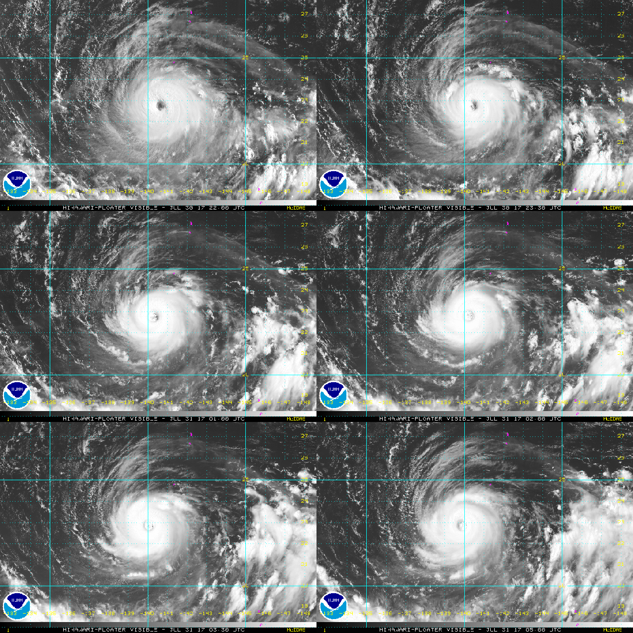
In the Pacific,  things aren’t nearly as active as they were earlier in the week. We still have Tropical Storm Irwin in the Eastern Pacific, but probably not for too much longer. In the Western Pacific, we have Super Typhoon Noru. Noru is impacting a few small islands well south of Japan, and has likely peaked in intensity with maximum sustained winds near 150 mph early Monday morning. There’s still plenty of uncertainty in regards to Noru’s future track, and it could threaten southern Japan later this week. For now, just take a look at this beautiful monster:
vis_lalo-animated
Visible satellite loop of Super Typhoon Noru. She’s a beauty, eh? Loop provided by NOAA.

The Atlantic Remains Quiet While the Pacific is Quite Active


The tropics remain quiet in the Atlantic right now, but it’s a different story in the Pacific, where there are currently six active systems, three in the East, and three in the West. This doesn’t even count the remains of a system crossing Hawaii today and another area being watched for development in the Western Pacific.

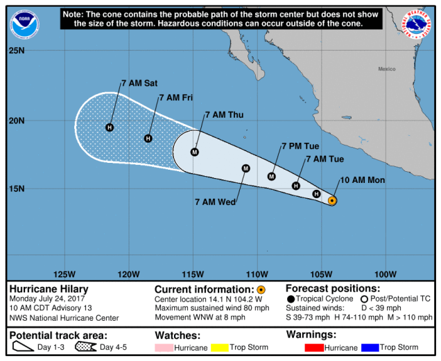
Starting with the Eastern Pacific, Hurricane Hilary is the strongest on the storms as well as the closest to land. At midday Monday, Hillary was centered about 340 miles south of Manzanillo, Mexico, moving towards the west-northwest at 8pm. This track is expected to continue for the next few days, bringing the system away from Mexico. Hilary has maximum sustained winds near 80 mph, but it is in an environment favorable for strengthening, and is expected to become a major hurricane over the next 24-36 hours. After that, a gradual weakening trend is expected.

EP092017_5day_cone_no_line
Forecast track for Hurricane Hilary. Image provided by the National Hurricane Center.


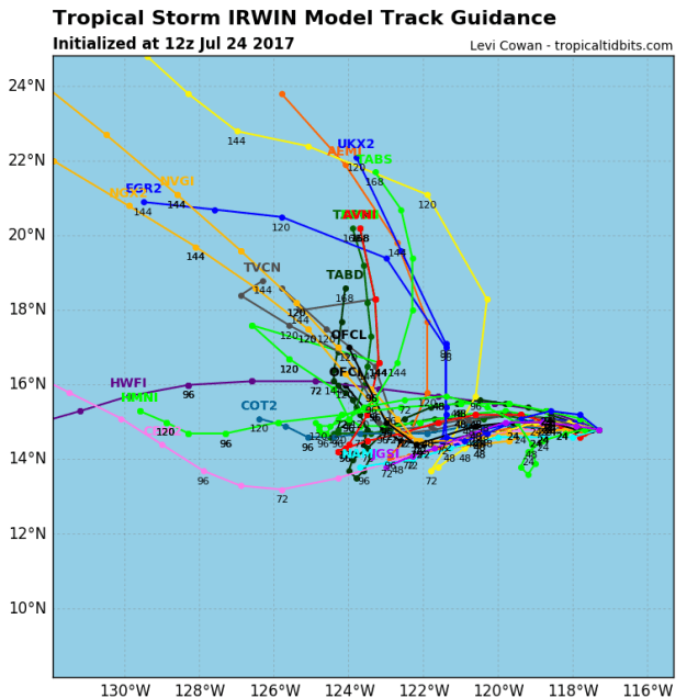
A little farther to the west is Tropical Storm Irwin. Irwin was centered about 750 miles southwest of Cabo San Lucas, Mexico at midday Monday, drifting westward at 3 mph. Irwin has maximum sustained winds of 60 mph, and additional strengthening is expected. Irwin should become a hurricane Monday night or Tuesday. The forecast track for Irwin is highly uncertain at the moment. Several of the computer models show an erratic motion for the storm, as it may interact with Hurricane Hilary. Whether or not it actually does interact with Hilary will have a large effect on its eventual track. Whether it does interact with Hilary or not, Irwin will remain over open water for the next several days, and is not a threat to any land areas.

10E_tracks_latest
Model forecasts for the track of Tropical Storm Irwin. There is plenty of disagreement among the models on its eventual track. Image provided by Tropical Tidbits.


Heading westward again, we come to Tropical Storm Greg. Greg’s top winds peaked at 60 mph on Friday, and it has been slowly weakening over the weekend. At midday Monday, Greg had top winds near 45 mph, and additional weakening is expected over the next few days. Greg was centered a little more than 1500 miles east of Hawaii, and was moving towards the west at 12 mph. Greg should dissipate well east of Hawaii later this week.

rbtop_lalo-animated
Tropical Storm Greg continues to gradually weaken over open waters. Loop provided by NOAA.


In the Central Pacific, there are no active storms at the moment. However, what’s left of Hurricane Fernanda is moving across Hawaii today, producing some gusty winds along with locally heavy showers and thunderstorms on Oahu and Kauai. At one point last week, Fernanda was a Category 4 hurricane with top winds of 145 mph over the open waters of the Eastern Pacific.

In the Western Pacific, we also have three active systems, and another area being watched for development.

abpwsair (1)
Satellite photo showing three active systems and another potential tropical system in the Western Pacific. Image provided by the Joint Typhoon Warning Center.


The strongest of the storms is Typhoon Noru (07W). Noru has been meandering around in the waters well southeast of Japan for several days, and this erratic motion should continue for another day or so before a general westward motion takes over. Noru currently has maximum sustained winds near 90 mph, and some further strengthening is possible over the next 36 hours. Noru will impact the Bonin Islands over the next few days with heavy rain and gusty winds. The GFS model shows the possibility that by next weekend, Noru could become a powerful typhoon in the waters south of Japan

1705-00
Forecast track for Typhoon Noru. Image provided by the Japan Meteorological Agency.


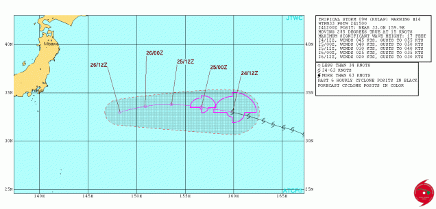
To the east of Noru is Tropical Storm Kulap (09W). Kulap is gradually weakening, and this should continue over the next few days. Kulap currently has top winds near 50 mph, but should weaken to a tropical depression by Tuesday. Kulap should continue moving off to the east, heading into the open waters of the Western Pacific, without impacting any additional land areas.

wp0917
Forecast track for Tropical Storm Kulap. Image provided by the Joint Typhoon Warning Center.


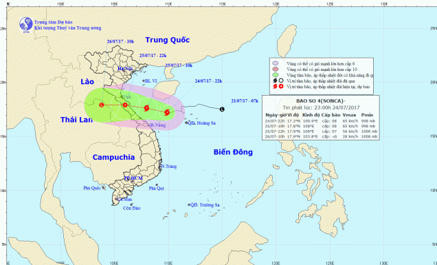
The storm that is the biggest threat to populated areas at the moment is Tropical Storm Sonca (08W). Sonca is currently centered about 160 miles east-northeast of Da Nang, Vietnam, driftng towards the southwest at 4 mph. A turn more toward the west is expected over the next 24 hours, with landfall in Vietnam expected by early Tuesday. Sonca has maximum sustained winds near 45 mph, and some additional strengthening is possible before landfall. The biggest threat from Sonca is flooding from heavy rains. Sonca could produce rainfall totals of 10-20 inches or more in parts of Vietnam and Laos.

2017072415z
Forecast track for Tropical Storm Sonca. Image provided by the Vietnam National Centre for Hydro-Meteorological Forecasting.


In addition to all the active systems, an area of disturbed weather about 375 miles northwest of Palau in the Western Pacific Ocean is being monitored for development. Conditions should be favorable for the system to develop over the next few days, and it could become a tropical depression later this week as it moves northward. Current computer model forecasts show the possibility of additional strengthening later this week, with the potential for a threat to the Philippines or Taiwan towards the end of the week.

99W_gefs_latest
GFS Ensemble forecast for the track and strength of a tropical disturbance in the Western Pacific Ocean. Image provided by Tropical Tidbits.


Computer model forecasts show that the active pattern will likely continue, especially in the Western Pacific, for the next few weeks at a minimum, with several more tropical cyclones possible. This is not a surprise, as the Western Pacific usually is the most active tropical cyclone basin in the world. So far in 2017, that hasn’t been the case. Although the number of storms has been close to normal in the Western Pacific (and the Atlantic), many have been weak and short-lived. Using a metric called Accumulated Cyclone Energy (ACE), which takes into account how strong a storm is, and how long it lasts, we see that so far this year, activity is below normal across the Western Pacific (and the Atlantic), and above normal in the Eastern Pacific.

Weekly Outlook: July 24-30, 2017

Hope you enjoyed the summer weather we had last week, because we’ve got some suck-tastic (Note: that’s a technical term) conditions on the way today. Don’t worry, things will improve during the week.

hires_tprecip_boston_46
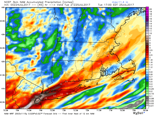
There could be quite a bit of rain around here today into Tuesday. Image provided by WeatherBell.

A frontal system will remain south of us today into Tuesday, with a wave of low pressure riding along it. That will bring us in some rain today, and it might be fairly heavy in spots, especially along the South Coast. Some localized flash flooding is possible.

sfct_anom.us_ne
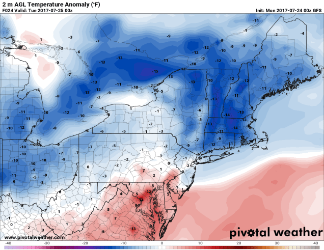
Temperatures could be 10-15 (or more) degrees below normal around here today. Image provided by Pivotal Weather.

But wait, the rain isn’t the only thing to make Monday suck-tastic! We’ve got cool temperatures too! How cool? We’re glad you asked, because we have the answer. How does 60s sound for highs? Some models are hinting that temperatures could stay in the 50s during the afternoon. That’s awfully chilly for mid-July, even in New England. In fact, we could set some record low max temperatures. We’re all going to have a case of the Mondays.

But wait, there’s more! We’ve also got coastal flooding! That’s right, thanks to a full moon giving us the highest tides of the month, and a persistent onshore wind, some coastal flooding is possible around high tide, especially along east-facing shorelines.

By Tuesday, the low pressure area will start to slowly pull away, though we could see a few leftover showers. The clouds may hang tough for a good chunk of the day, and temperatures may also stay cool, so it won’t be the best of days, but at least it won’t be as bad as today.

Things get much better on Wednesday when high pressure builds in, bringing us sunshine, milder temperatures, and low humidity. Don’t get used to it. The humidity returns on Thursday along with the chance for some showers and thunderstorms ahead of another cold front. That front will move through early Friday, and stall out. We’ll have to see exactly where it stalls, as a wave of low pressure is going to ride along that front on Friday. If it stalls out south of New England, as at least one model shows, then skies could clear out and the rain stays off to our south. If the front stalls out right across the area, as another model shows, then we could be looking at another round of heavy rain and thunderstorms for Friday, with unsettled conditions lingering into Saturday. High pressure returns on Sunday with drier and cooler conditions.

Monday: Cloudy, breezy, and cool with periods of rain, possibly heavy at times. High 60-67.

Monday night: Cloudy with some additional showers or drizzle around. Low 54-61.

Tuesday: Mostly cloudy with a chance for a few more showers. High 64-71.

Tuesday night: Becoming clear to partly cloudy. Low 53-60.

Wednesday: Sunshine and some afternoon clouds. High 75-82.

Thursday: Partly sunny, becoming humid, chance for a shower or thunderstorm. High 78-85.

Friday: Mostly cloudy with a chance of rain and thunderstorms. High 73-80.

Saturday: Intervals of clouds and sun, chance for a few additional showers. High 75-82.

Sunday: Partly to mostly sunny and drier. High 76-83.

Weekly Outlook: July 17-23, 2017

Here we are in the middle of summer, and we’re still waiting to have a full week of actual “summer” weather. Well, guess what? That wait may finally be over! That’s right, some actual bona-fide “summer weather” looks like it’ll be here for the next 7 days.

What’s actually going on for most of the week is fairly simple to explain. High pressure will remain in place off the East Coast for the next several days. That means we’ll have warm and increasingly humid conditions right through Wednesday. When it’s warm and humid, we also have the daily chance for showers and thunderstorms. We’re not expecting any widespread severe weather, but any storms that do form could produce some gusty winds and heavy downpours. Thunderstorms may be a bit more widespread as we head into Thursday, especially Thursday evening and night, as a cold front moves towards the region. Ahead of the front, temperatures should reach the 90s across much of the region, making for an oppressive day. Of course, some of you enjoy that, so Thursday might be considered the “best” day of the week by those standards. The front moves through Thursday night, and drier and slightly cooler conditions return for Friday and Saturday. Clouds and maybe more showers and thunderstorms could return on Sunday ahead of another front.

gfs_t2max_boston_17 (1)
Thursday is looking like a very toasty afternoon across the area. Image provided by WeatherBell.

Monday: Partly sunny skies, a late-day shower or thunderstorm is possible. High 81-88.

Monday night: Partly to mostly cloudy. Low 61-68.

Tuesday: A mix of sun and clouds, scattered showers and thunderstorms in the afternoon. High 78-85.

Tuesday night: Clear to partly cloudy. Low 63-70.

Wednesday: Sunshine gives way to increasing clouds with afternoon showers and thunderstorms possible. High 84-91.

Thursday: Partly sunny, hot, and humid, with a chance for late-day showers and thunderstorms. High 88-95.

Friday: A mix of sunshine and clouds, less humid. High 82-89.

Saturday: Sunshine and a few afternoon clouds. High 78-85.

Sunday: More clouds than sun with a chance for showers and thunderstorms. High 80-87.

Weekly Outlook: July 10-16, 2017

We’re approaching the mid-point of meteorological summer, so you’d think that we should finally have a week of typical “summer weather”, right? C’mon, you should know better. This is New England, the only thing typical about the weather here is that is typically changes all the time. This week won’t be an exception.

The week will start off with high pressure moving off the East Coast, so we’ll have warm and increasingly humid air in place. So far, so good, right? A cold front approaches on Tuesday, likely triggering some showers and thunderstorms. A few strong storms are possible, but the bulk of the severe weather should remain well to our north and west. That front looks like it’s going to stall out near the South Coast on Wednesday. This may keep clouds and some showers around, especially the closer you get to the South Coast. A couple of weak systems will move through for Thursday and Friday, with more rain and unseasonably cool temperatures, though it could remain warm south of the Mass Pike – south of the front. Things should improve next weekend, both in the skycover and temperature departments.

sfct.us_ne (1)
A frontal system could set up quite a different in temperature across the region Thursday afternoon. At least one model shows afternoon temperatures dropping into the 50s across parts of Maine and New Hampshire, while the South Coast could be pushing 90. Image provided by Pivotal Weather.

Monday: Sunshine and some afternoon clouds. High 80-87.

Monday night: Partly cloudy, showers possible late at night. Low 63-70.

Tuesday: Partly sunny, additional showers and thunderstorms are likely. High 80-87.

Tuesday night: Partly to mostly cloudy, showers and thunderstorms taper off in the evening. Low 65-72.

Wednesday: Partly sunny, chance for a few showers and thunderstorms. High 78-85.

Thursday: Intervals of clouds and sunshine with more showers and thunderstorms possible. High 70-78 north of the Mass Pike, 78-85 south of the Mass Pike. Temperatures could drop sharply in the afternoon.

Friday: Partly to mostly cloudy with a chance of rain and showers. High 63-70 north of the Mass Pike, 70-77 south of the Mass Pike.

Saturday: Partly sunny, chance for a shower or thunderstorm. High 75-82.

Sunday: A mix of sun and clouds. High 80-87.

two_atl_5d0
There is a chance that another system could develop in the Atlantic later this week. Image provided by the National Hurricane Center.

Finally, we’ll address the tropics again. Right now, the Atlantic is relatively quiet. A weak tropical wave is passing south of the Cape Verde Islands, producing some showers and thunderstorms. As we normally do at this time of year, we’ll keep an eye on it as it makes it’s way across the Atlantic Ocean this week. Conditions might be favorable for some development, but if any occurs, it likely won’t happen for several more days. That being said, some of the computer models have been suggesting that this system will develop, which has sent some of the weather weenies on the internet into a frenzy. If we had a dollar for every time the models tried to develop a tropical system and it never happened, we’d be filthy rich right now. These models are notoriously bad and predicting the development of these systems. We’re talking UMass-Amherst hockey level of ineptitude. We’re not going to state right now that this system won’t develop. These models are right on occasion, and there is always a chance. But right now, that chance is pretty low. If it does develop, we’ll let you know if there’s anything to worry about.

Weekly Outlook: July 3-9, 2017

HoustonKansasCity 138
We’ll have perfect weather for fireworks displays on the Fourth of July.

We’ve made it to July, and the stubborn pattern we had for much of the Spring and well into June is finally gone.

We’ll start right off with the forecast for Tuesday, since that’s the day people are most interested in. Planning a barbecue? Perfect weather for it. Heading into the pool or to the beach? Bring the sunscreen. Watching fireworks in the evening? No problems expected. Stuck working because your chosen profession doesn’t take holidays? Sucks to be you, but don’t expect anyone to feel bad for you.

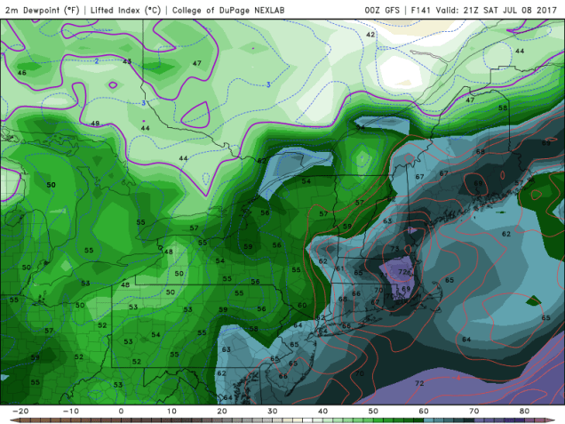
As for the rest of the week, sunshine and warm temperatures will be here for the next few days, along with low humidity, as high pressure builds in across northern New England. There is a slight chance for a shower or thunderstorm this afternoon as a weak upper-level disturbance moves through, mainly along the South Coast. However, the bulk of the activity looks like it should remain well to our south and west. As the high slides offshore later this week, humidity will start to creep back into the region. With humidity comes the risk for afternoon showers and thunderstorms. That risk looks to be the greatest Friday and Saturday as another cold front starts to approach the region. While it’s still a bit early, and the timing of the front will play a critical role, we wouldn’t be surprised to see some severe storms develop on Saturday, if everything comes together. We’ll monitor this as the week progresses. High pressure will build in behind the front with drier conditions for next Sunday.

GFSNE_con_sbcape_141
A moist and unstable airmass may be in place ahead of a cold front next Saturday, which could help to produce strong to severe thunderstorms. Image provided by the College of Dupage.
GFSNE_sfc_dewp_141
A moist and unstable airmass may be in place ahead of a cold front next Saturday, which could help to produce strong to severe thunderstorms. Image provided by the College of Dupage.

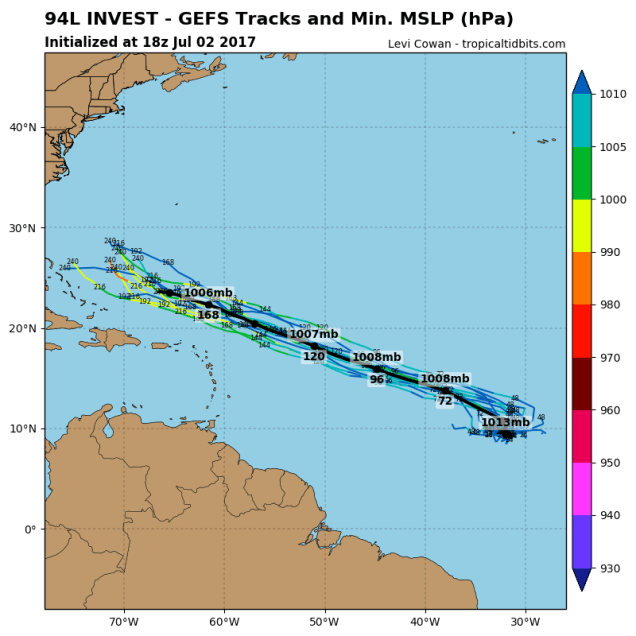
While we’ve got a fairly simple forecast here for most of the week, things are starting to cook out in the Atlantic. A tropical disturbance located well east of the Lesser Antilles has the potential to develop into a tropical depression later this week.  There’s nothing to worry about now, but some of the models (not all), try to develop the system into a hurricane at some point, and possibly become a threat to the East Coast or Bermuda about 2 weeks from now. The odds of this happening are still pretty low, so we wouldn’t worry about it too much, but we’ll certainly keep our eyes on this system, as well as the rest of the tropics.

94L_gefs_latest
GFS Ensemble forecasts for the track of a tropical disturbance in the Central Atlantic. Image provided by Tropical Tidbits.


Monday: A mix of sun and clouds, just a slight chance for an afternoon shower or thunderstorm near the South Coast. High 81-88.

Monday night: Clear to partly cloudy. Low 58-65.

Tuesday: Sunshine and a few clouds. High 77-84.

Tuesday night: Clear skies. Perfect weather for fireworks in the evening. Low 55-62.

Wednesday: Mostly sunny. High 78-85.

Thursday: A sunny start, then clouds develop along with the chance for some afternoon showers and thunderstorms, becoming humid. High 77-84.

Friday: A mix of sun and clouds, humid, chance for some afternoon showers and thunderstorms. High 80-87.

Saturday: Partly sunny, more showers and thunderstorms are possible. Some of the storms could be strong to severe in the afternoon. High 83-90.

Sunday: Mostly sunny with a few afternoon clouds, drier. High 75-82.

Weekly Outlook: June 25 – July 2, 2017

Can you believe that we are just about at the halfway point of the year already? Yup, before you know it, we’ll be talking about football, then hockey, and snowstorms, and….well, we’ll stop there before we upset everyone.

gfs_6hr_snow_acc_wyoming_21
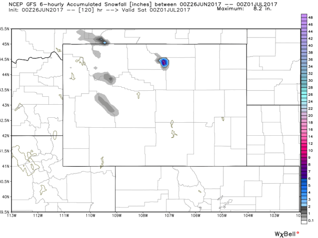
Yes, it’s late June, but some snow is possible in the higher elevations of Wyoming and Montana later this week. Image provided by WeatherBell.

Well, we are supposedly in the middle of summer now, but the weather pattern is definitely not a typical summertime pattern. An upper-level trough of low pressure will move into the Northeast for the start of the week. That means that we’ll start off each day with sunshine, but clouds will pop up and likely some showers or thunderstorms each afternoon. High pressure starts to build in on Wednesday with drier and milder conditions. By Thursday, a warm front will cross the region, with more showers and thunderstorms expected. Friday will finally be a typical summer day, with warm and humid conditions, but also the chance for more showers and thunderstorms. Next weekend, things get tricky again. A back door cold front will try to drop down from the north and will likely stall out somewhere in our vicinity. Exactly where it stalls will have a huge impact on the temperatures around here. South and west of the front, it will remain humid, with temperatures well into the 80s or even the 90s. North and east of the front, temperatures may stay in the 60s and lower 70s, especially near the coastline. Of course, since, it’s the start of the long holiday weekend, these details are fairly important. Hopefully, we’ll have more clarity as we head through the week.

Monday: A sunny start, then clouds develop along with afternoon showers and thunderstorms. High 74-81.

Monday night: Showers and thunderstorms taper off in the evening, then skies clear out overnight. Low 52-59.

Tuesday: Clouds return along with the chance for more showers and thunderstorms. High 72-79.

Tuesday night: Clearing skies. Low 53-60.

Wednesday: Partly to mostly sunny, just a slight chance for a shower or thunderstorm. High 72-79.

Thursday: A mix of sun and clouds, breezy, chance for showers and thunderstorms, mainly late in the day and at night. High 76-83.

Friday: Partly sunny and breezy, more showers and thunderstorms may develop. High 83-90.

Saturday: A mix of sun and clouds, chance for showers and thunderstorms. High 76-83, possibly warmer well inland and cooler right along the coast.

Sunday: More clouds than sun with more showers and thunderstorms around. High 80-87.

rbtop_lalo-animated
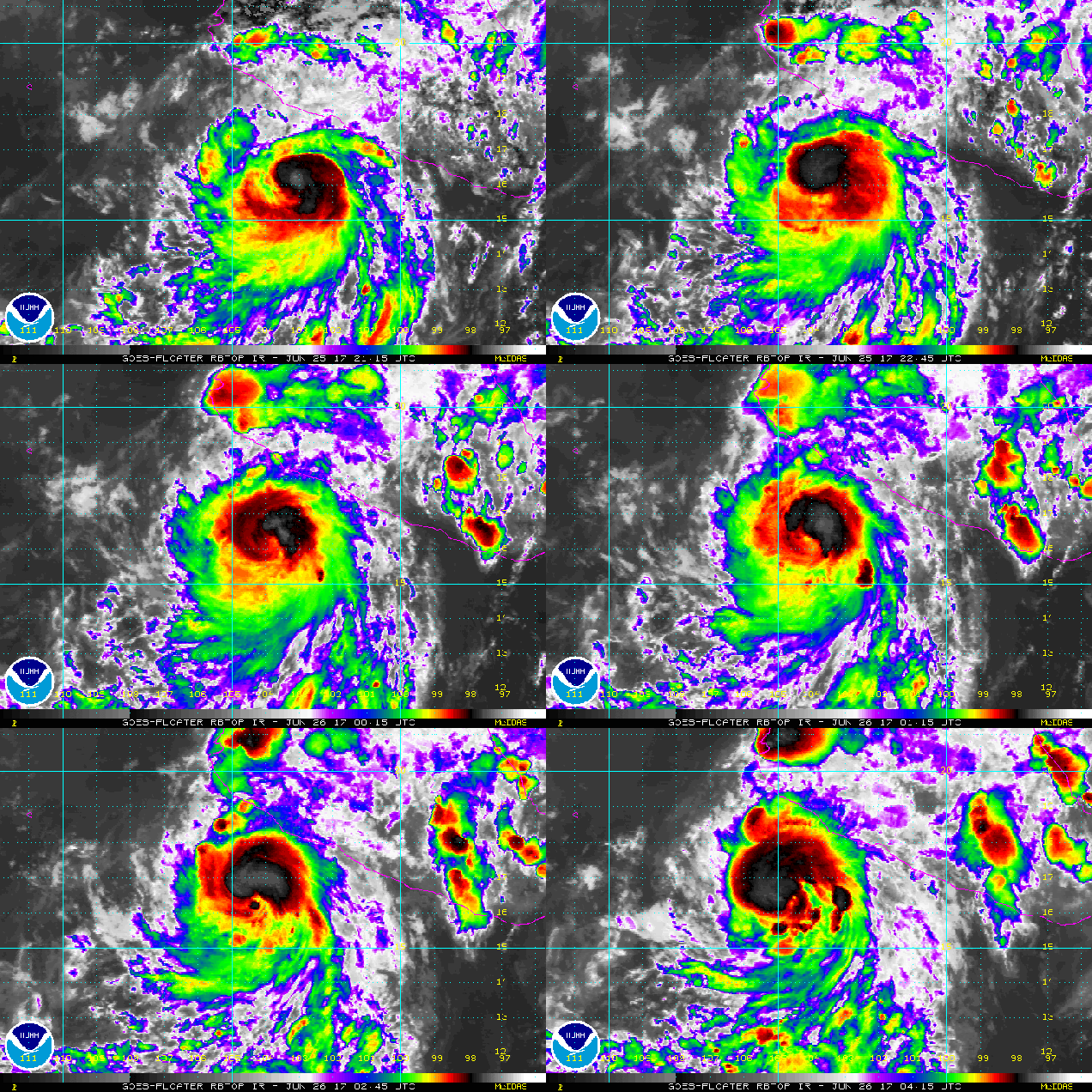
The Atlantic remains quiet, but in the Pacific, Tropical Storm (soon to be Hurricane) Dora is intensify just off the southern Mexican coastline. Loop provided by NOAA.

Weekly Outlook: June 19-25, 2017

We apologize for the brief post this week, but we wanted to make sure we still provided you with an update, especially since Monday could be an active day.

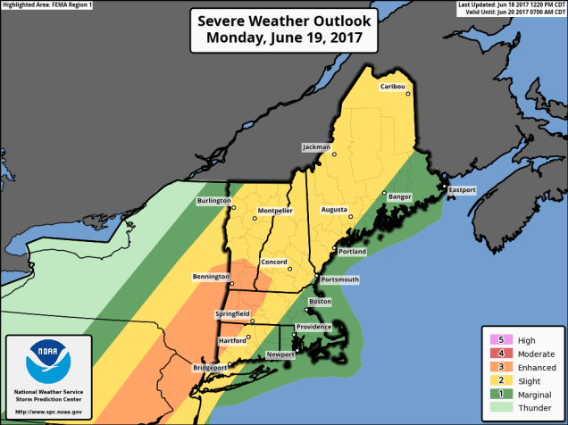
A cold front will approach the region on Monday, and with a warm and humid airmass in place, that front will likely trigger some strong to severe thunderstorms during the afternoon and evening. The strongest storms will likely occur west of our area, but some of them will likely survive into eastern New England. Some of the storms will produce heavy downpours, strong winds, hail, and possibly even a tornado or two.

fema01_swody2
Severe weather is possible across New England on Monday, especially northern and western areas. Image provided by the Storm Prediction Center.

High pressure will build in for the middle of the week with much drier conditions. The high slides offshore late in the week, allowing warm and humid conditions to return. Another front approaches next weekend, with more showers and thunderstorms possible.

Monday: Becoming cloudy and breezy with showers and thunderstorms developing, some of which could become strong to severe. High 80-87, cooler along the South Coast.

Monday night: Showers and thunderstorms taper off in the evening, then skies clear out late at night. Low 65-72.

Tuesday: Becoming mostly sunny. High 77-84.

Tuesday night: Clear to partly cloudy. Low 57-64.

Wednesday: Sunshine and some afternoon clouds. High 75-82.

Thursday: A sunny start, high clouds start to move in during the afternoon. High 76-83.

Friday: A mix of sun and clouds, warmer, and more humid, with a chance for a few showers and thunderstorms. High 81-88, cooler along the South Coast.

Saturday: More clouds than sun with more showers and thunderstorms possible.  High 78-85.

Sunday: A mix of sun and clouds, chance for a shower or thunderstorm. High 76-83.

rb-animated
Two tropical disturbances are being monitored right now, one near the Yucatan, and one east of the Lesser Antilles. Loop provided by NOAA.

The tropics have also awakened. There a disturbance east of the Lesser Antilles that could become a tropical depression on Monday. Tropical Storm Warnings have already been issued for some of the islands. A second disturbance near the Yucatan could become more of a threat to the Gulf of Mexico later this week.

Weekly Outlook: June 12-18, 2017

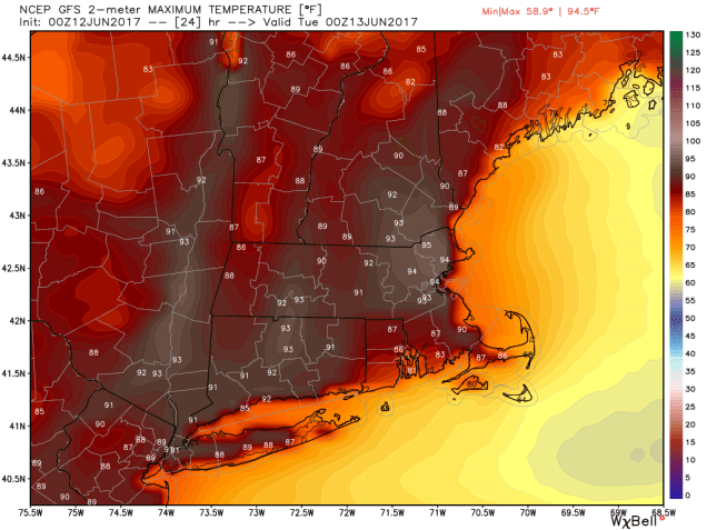
Well, many of you wanted it, now you’ve got it. The heat has arrived, and the humidity will be creeping up as well. It won’t last too long though, so you’d better enjoy it while it’s here. We’ll cool off for the middle and end of the week, then start to warm back up again next weekend.

gfs_t2max_boston_5
It’s going to be quite toasty today away from the South Coast. Image provided by WeatherBell.

With a Bermuda high sitting off the East Coast and a ridge of high pressure aloft over the Eastern US, we have all the ingredients needed for a couple of hot days across the region. Plenty of sunshine and southwest winds mean temperatures should soar into the 90s again today, mainly away from the South Coast. Tuesday also looks hot, but a cold front will approach the region during the afternoon. How quickly the clouds move in ahead of the front will determine how hot we actually get. As the front moves through in the afternoon, it will trigger showers and thunderstorms. Some of the storms could be quite strong, with gusty winds, heavy, and heavy downpours. Skies clear out behind the front Tuesday night, and high pressure builds in for Wednesday and Thursday, bringing cooler temperatures with it.

Things get a little trickier for Friday and the weekend. A warm front will move through on Friday, bringing warmer and more humid air back into the region for the weekend. This will also increase the chance for showers and thunderstorms, especially on Saturday. By Sunday, another cold front will be approaching the region, which means more showers and thunderstorms are possible. The amount of cloud cover that we get each day will play a big factor in determining how warm each day ends up.

Monday: Sunshine and a few clouds, humid. High 88-95, except 80-87 along the South Coast and Cape Cod.

Monday night: Clear to partly cloudy, muggy. Low 67-74.

Tuesday: A mix of sun and clouds, scattered showers and thunderstorms in the afternoon. Some of the storms may contain hail. gusty winds, and heavy downpours. Humid with high 85-92.

Tuesday night: Becoming mostly clear. Low 58-65.

Wednesday: Partly to mostly sunny. High 69-76, cooler along the coast.

Thursday: Sunshine and some high clouds. High 68-75.

Friday: Increasing clouds, showers and thunderstorms possible late in the day and at night. High 65-72.

Saturday: Partly sunny and becoming humid, chance for showers and thunderstorms. High 70-77.

Sunday: A mix of sun and clouds, humid, more showers and thunderstorms possible. High 80-87, except 73-80 along the South Coast and Cape Cod.

sn10_acc.us_nw
Things could always be worse – several inches of snow are expected across some of the mountains of the West over the next few days. Image provided by Pivotal Weather.

Weekly Outlook: June 5-11, 2017

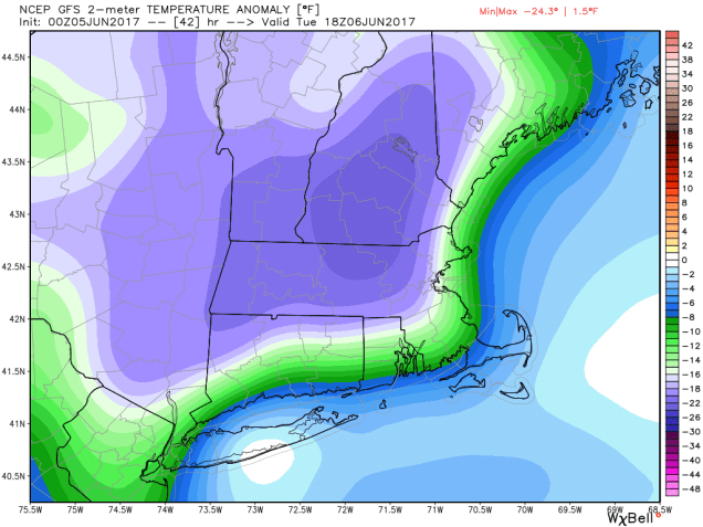
After a rather chilly and damp May, things haven’t changed too much to start June. In fact, the next couple of days will be downright suck-tastic (that’s a technical term). While we’ll see some improvement in this pattern as we head towards the end of the week, a flip to summer-like weather is probably still at least a week away. Even then, we’re not sure how long a summer-patter may hang around.

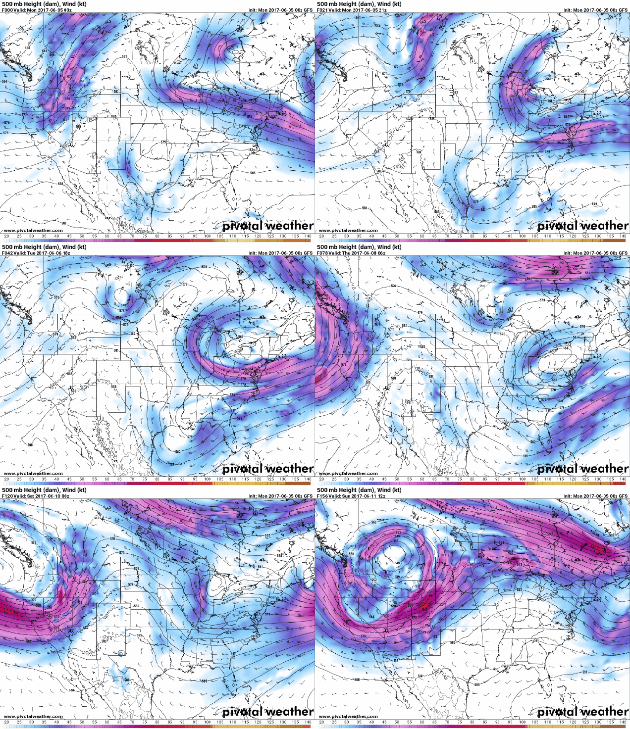
Stop us if you’ve heard this before, but for the first half of the week, an upper-level low pressure area will remain in place across the Northeast. That means showers and cool temperatures through at least Tuesday. A weak area of high pressure will try to build in at the surface on Wednesday, but with that upper-low hanging around, we’ll still see plenty of clouds, and possibly a few showers. In fact, that will probably be repeated each day through Saturday. None of the days will be a washout, as we won’t have any organized storm systems moving near the area. However, each day will feature plenty of clouds along with some sunny breaks, along with showers popping up. Temperatures will gradually warm up as we head through the week, but will remain below normal. As we get into the middle of June “normal” is generally lower to middle 70s, so we’re looking at highs in the 60s later this week.

gfs.500wh.conus.2017060500-loop
As has been the case for the past several weeks, an upper-level low pressure area will keep us cool and damp this week. Loop provided by Pivotal Weather.


Things *might* start to change on Sunday. By then, there are some indications that the upper-level low may start to move out and be replaced by a ridge of high pressure. That would allow for sunshine and warmer temperatures. Of course, the models haven’t been that trustworthy lately, and it was only a few days ago that they showed this transition taking place towards Thursday or Friday, not Sunday. So, we remain a bit skeptical that it will occur by Sunday.

gfs_t2m_a_f_boston_8
Temperatures will be 15-25 degrees below normal Tuesday afternoon. Image provided by WeatherBell.

Just think, it could have been a lot worse. If we had this pattern in January and February instead of May and early June, it would have been reminiscent of the winter of 2014-2015, when we got absolutely buried with record snow in a 6 week period.

Monday: Cloudy with occasional showers and drizzle. High 55-62.

Monday night: More showers, drizzle, and fog expected. Low 47-54.

Tuesday: Breezy and cool with periods of rain and showers expected. Temperatures hold steady for much of the day, possibly dropping a few degrees.

Tuesday night: Showers, drizzle, and fog persist. Low 44-51.

Wednesday: Partly to mostly cloudy with a chance for more showers.  High 54-61.

Thursday: Partly sunny, chance for a few showers. High 59-66.

Friday: Intervals of clouds and sunshine with additional showers possible. High 66-73.

Saturday: Partly sunny, a few more showers are possible. High 71-78.

Sunday: A mix of sun and clouds, slight chance for a shower. High 72-79.

Many models are showing the possibility that the start of next week features some real summer weather, with temperatures getting into the 90s and dewpoints near or above 70s. We’ll see if they stick to their guns as the week goes on.