Hope you enjoyed the summer weather we had last week, because we’ve got some suck-tastic (Note: that’s a technical term) conditions on the way today. Don’t worry, things will improve during the week.
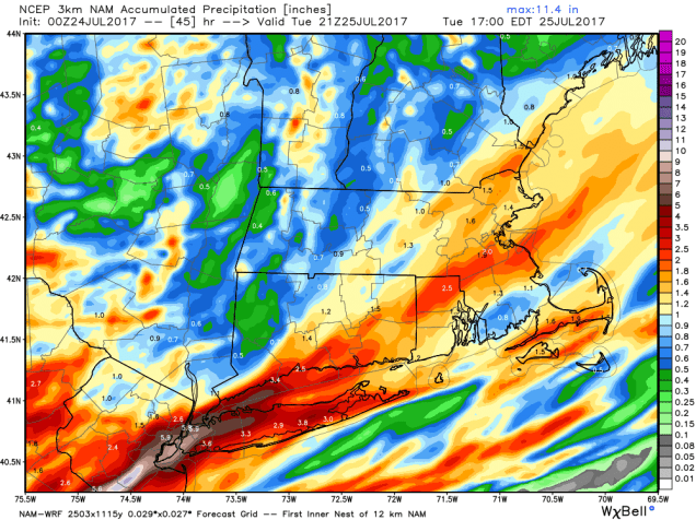
A frontal system will remain south of us today into Tuesday, with a wave of low pressure riding along it. That will bring us in some rain today, and it might be fairly heavy in spots, especially along the South Coast. Some localized flash flooding is possible.
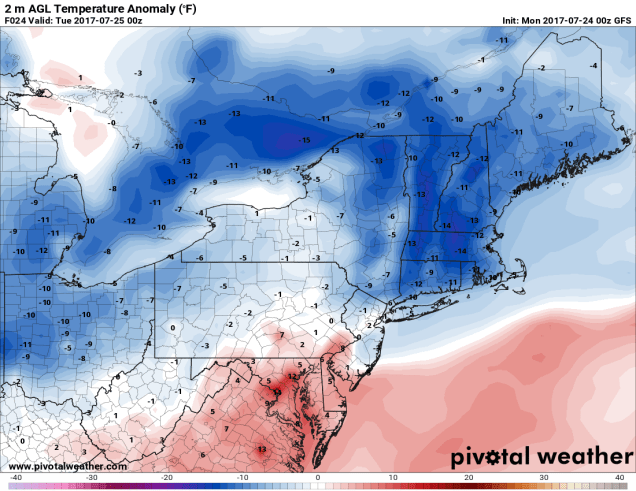
But wait, the rain isn’t the only thing to make Monday suck-tastic! We’ve got cool temperatures too! How cool? We’re glad you asked, because we have the answer. How does 60s sound for highs? Some models are hinting that temperatures could stay in the 50s during the afternoon. That’s awfully chilly for mid-July, even in New England. In fact, we could set some record low max temperatures. We’re all going to have a case of the Mondays.
But wait, there’s more! We’ve also got coastal flooding! That’s right, thanks to a full moon giving us the highest tides of the month, and a persistent onshore wind, some coastal flooding is possible around high tide, especially along east-facing shorelines.
By Tuesday, the low pressure area will start to slowly pull away, though we could see a few leftover showers. The clouds may hang tough for a good chunk of the day, and temperatures may also stay cool, so it won’t be the best of days, but at least it won’t be as bad as today.
Things get much better on Wednesday when high pressure builds in, bringing us sunshine, milder temperatures, and low humidity. Don’t get used to it. The humidity returns on Thursday along with the chance for some showers and thunderstorms ahead of another cold front. That front will move through early Friday, and stall out. We’ll have to see exactly where it stalls, as a wave of low pressure is going to ride along that front on Friday. If it stalls out south of New England, as at least one model shows, then skies could clear out and the rain stays off to our south. If the front stalls out right across the area, as another model shows, then we could be looking at another round of heavy rain and thunderstorms for Friday, with unsettled conditions lingering into Saturday. High pressure returns on Sunday with drier and cooler conditions.


Monday: Cloudy, breezy, and cool with periods of rain, possibly heavy at times. High 60-67.
Monday night: Cloudy with some additional showers or drizzle around. Low 54-61.
Tuesday: Mostly cloudy with a chance for a few more showers. High 64-71.
Tuesday night: Becoming clear to partly cloudy. Low 53-60.
Wednesday: Sunshine and some afternoon clouds. High 75-82.
Thursday: Partly sunny, becoming humid, chance for a shower or thunderstorm. High 78-85.
Friday: Mostly cloudy with a chance of rain and thunderstorms. High 73-80.
Saturday: Intervals of clouds and sun, chance for a few additional showers. High 75-82.
Sunday: Partly to mostly sunny and drier. High 76-83.
