Weekly Outlook: March 22-28, 2021

We’ve got a fantastic stretch of weather coming up for a good chunk of the upcoming week thanks to a large area of high pressure.

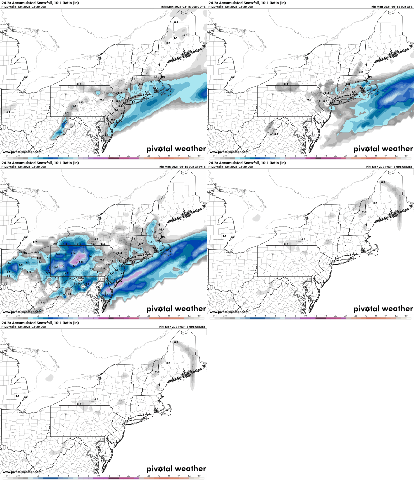
Dry and mild conditions are expected through at least the first part of Wednesday thanks to a large area of high pressure. Along the coast, temperatures will be cooler, thanks to a seabreeze each of the next few afternoons, but once you get inland, temperatures should reach the 60s each day. Things could be a little tricky on Wednesday however. Low pressure will meander off to the south for the first half of the week, with little impact on us. However, by late Wednesday it will start to lift out, sending some clouds in along with the possibility of a few showers. If the showers are more widespread than we currently expect or the clouds are thicker, temperatures could end up quite a bit cooler than our forecast currently shows.

A little rain is possible late Wednesday, but not all of the models agree on it. Images provided by Pivotal Weather.

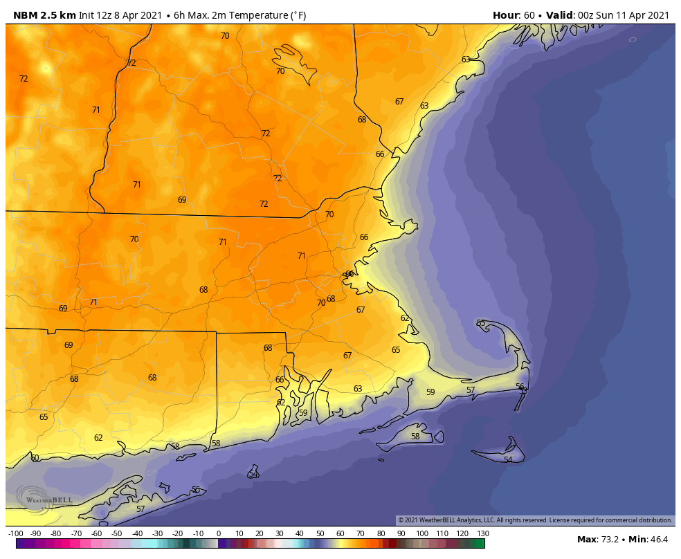
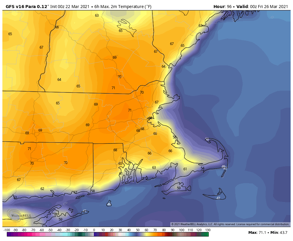
High pressure then builds back in south of the region, resulting in southwesterly winds bringing even milder air in for Thursday, possibly right to the coastline. Unfortunately, we’ll also have more cloudcover, as another low pressure area makes its way into the eastern Great Lakes. With enough sunshine, temperatures could top 70 degrees in many spots. That system will bring us some rain for Thursday night into Friday as it passes to our north and west, before a cold front crosses the region during the day on Friday. Friday’s temperatures will be dependent on the timing of the front, the later it moves through, the more likely that it’ll be warmer. If the rain lingers long enough and the cold air moves in fast enough, some wet snow could mix in before everything winds down. We don’t expect this to be the case, but can’t completely rule it out just yet.

Temperatures could reach 70 on Thursday, depending on how much sunshine we get. Image provided by WeatherBell.

Behind that front, more seasonable conditions are expected for Saturday, but Sunday is where things could get interesting again. Another low pressure system will head toward the region, with some rain possible by late Sunday or Sunday night. The problem is, we’ll have some cold air nearby, so it may not be just rain, at least for part of the region. There’s a chance we could have some snow from this system, especially the farther north and west you go from Boston. This is hardly a lock, and things will change numerous times between now and then, but it’s just another example that even though it’s now Spring, that doesn’t mean we’re entirely done with Winter just yet.

A few members of the GFS Ensemble show the potential for at least a little snow Sunday night. Image provided by Weathermodels.com

Monday: Lots of sunshine. High 57-64, cooler along the coast.

Monday night: Clear skies. Low 30-37.

Tuesday: Sunshine and some afternoon high clouds. High 57-64, cooler along the coast.

Tuesday night: Partly cloudy. Low 33-40.

Wednesday: Thickening clouds with some showers possible during the afternoon and evening. High 52-59, cooler along the coast.

Thursday: More clouds than sunshine. High 62-69, cooler along the South Coast and Cape Cod.

Friday: Cloudy and breezy with showers likely, possibly mixing with wet snow before ending at night. High 58-65, cooler along the South Coast and Cape Cod.

Saturday: Intervals of clouds and sun, cooler. High 53-60.

Sunday: Early sun, then becoming cloudy with rain possible late in the day and at night, possibly mixed with some wet snow well to the north and west. High 49-56.

Weekend Outlook: March 19-22, 2021

Spring doesn’t start until Saturday morning, and Mother Nature is going to remind us of that fact.

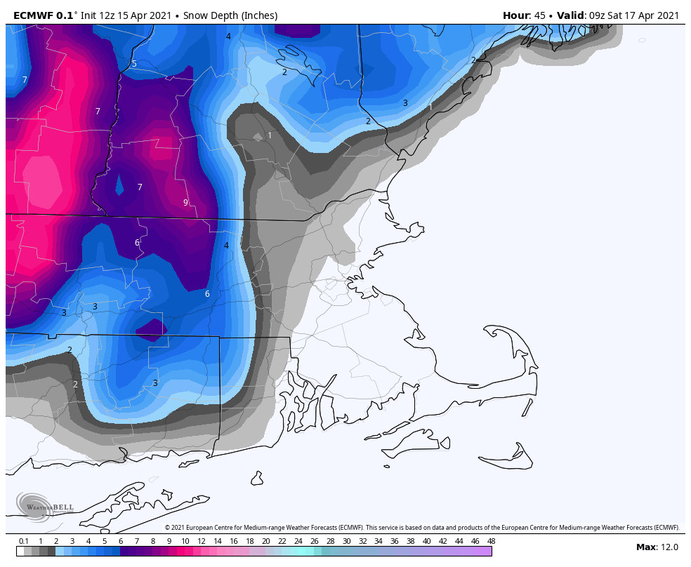
The storm system responsible for all the severe weather over the past few days will pass south of the region tonight, with rain likely. However, as colder air settles in tonight, we’ll see that rain change over to snow from north to south. We’re not expecting much snow, with most places likely seeing an inch or less, possibly 2 inches in a few spots. That’ll be just enough to remind you that it’s still technically winter.

We’ll have a little snow overnight, but it won’t last too long. Image provided by WeatherBell.

We’ll clear out Friday afternoon, but it will be windy and chilly. After that, high pressure builds in for the weekend with sunshine and moderating temperatures. We’ll get into the 40s on Saturday, while Sunday and Monday will see temperatures in the 50s and possibly 60s.

Temperatures could approach 60 on Sunday. Image provided by Weathermodels.com

Thursday night: Breezy with rain likely, changing to wet snow, ending by daybreak. Low 21-28.

Friday: Early clouds, then clearing and windy in the afternoon. High 33-40.

Friday night: Clear skies. Low 20-27.

Saturday: Plenty of sunshine. High 48-55, coolest along the coast.

Saturday night: Clear skies. Low 26-33.

Sunday: Sunny and milder. High 53-60, coolest along the coast.

Sunday night: Mostly clear. Low 28-35.

Monday: Sunshine and a few clouds. High 54-61, coolest along the coast.

Weekly Outlook: March 15-21, 2021

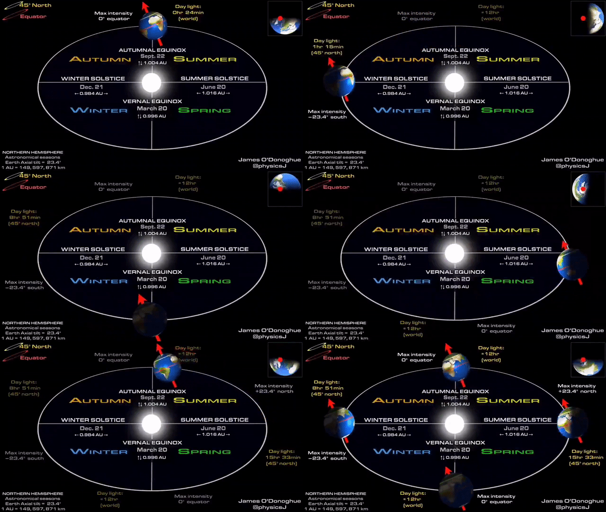
Astronomical Spring officially begins Saturday morning at 5:37am, but it’s going to feel likely winter for a couple more days.

Spring begins Saturday morning. Image provided by EarthSky.org

Most of this week will be fairly dry, as today will be with high pressure building in. Today will also be quite cold, with many places likely not reaching the 30-degree mark. Add in a little wind, especially this morning, and it definitely won’t feel like mid-March, with wind chills in the single numbers and teens. As the high slides off to the east, temperatures will start to moderate a bit on Tuesday, but it will remain on the chilly side. Clouds will also start to move back in ahead of a weak low pressure system. That system will pass to sour south Tuesday night and Wednesday, but may produce a few snow showers, especially near the South Coast. We’re not expecting anything to accumulate, and for the bulk of the region, we’re not expecting much, if anything, to even fall from the clouds.

Temperatures will be 15-20 degrees below normal today. Image provided by Weathermodels.com

We’ll see some sunshine return on Wednesday to parts of the area along with temperatures continuing to moderate. However, the next system moves in for Thursday into Friday. This one doesn’t look as weak or as far south, but temperatures will be a bit milder to start. We could see some rain or snow showers, especially Thursday night into Friday morning, especially south of the Mass Pike, but again, this does not look like a big deal. Colder weather will settle in on Friday as the system pulls away, but temperatures will moderate again over the weekend thanks to high pressure building back in.

Some models show the possibility for a little snow Thursday night into Friday. Images provided by Pivotal Weather.

Monday: Partly to mostly sunny and breezy, especially in the morning. High 23-30.

Monday night: Clear to partly cloudy. Low 9-16.

Tuesday: Early sun, then thickening clouds. High 34-41.

Tuesday night: Partly to mostly cloudy with some snow showers possible, mainly south of the Mass Pike. Low 23-30.

Wednesday: Mostly cloudy, some sunny breaks are possible across southern New Hampshire. High 43-50.

Thursday: Plenty of clouds with some showers possible, maybe mixing with snow at night. High 49-56.

Friday: Mostly cloudy, breezy, and colder, with a chance of snow showers. High 33-40.

Saturday: A few clouds early, otherwise mostly sunny. High 42-49.

Sunday: Lots of sunshine, milder. High 47-54.

Weekend Outlook: March 12-15, 2021

After today’s warm weather, it is definitely time for change, with cooler weather working its way into the region over the next few days.

Temperatures have reached or exceeded 70 across much of the region this afternoon. Image provided by NOAA.

A cold front moves crosses the area late tonight with some clouds and possibly a shower or two, but the more noticeable impact will be cooler temperatures on Friday. Late Friday, a stronger cold front will move through. Like the first one, there will be little moisture with this front, but gusty northwest winds may create some issues at night, but not nearly as bad as the front from a week and a half ago. They will also bring much cooler weather in for Saturday. Winds will diminish during the day on Saturday with sunshine and temperatures closer to where they should be in mid-March. Sunday should be fairly similar with sunshine and seasonably cool temperatures, but winds may pick up a little. Monday also looks dry but breezy and even colder, with most places staying in the 30s all day.

Average high temperatures for the middle of March are in the middle 40s. Image provided by Weathermodels.com

Thursday night: Partly to mostly cloudy, chance for a few showers. Low 45-52.

Friday: A few showers near the South Coast and Cape Cod early, otherwise becoming mostly sunny and breezy. High 55-62.

Friday night: Clear to partly cloudy, windy. Low 23-30.

Saturday: Mostly sunny, breezy during the morning. High 38-45.

Saturday night: Clear to partly cloudy. Low 25-32.

Sunday: Partly to mostly sunny and breezy. High 40-47.

Sunday night: Clear to partly cloudy, breezy. Low 12-19.

Monday: Sunny, breezy, and colder. High 28-35.

Weekly Outlook: March 8-14, 2021

Things you won’t need this week: Snow shovels, heavy winter coats. Things you will need this week: Sunglasses, lighter jackets, short-sleeve shirts. Yup, warmer weather is finally on the way.

High pressure settles off the East Coast this week, and that means southwesterly winds pumping milder air into the region. Of course, if you are in a place where a southwest wind is coming off the water, like the South Coast, Cape Cod, or Cape Ann, then it won’t be quite as warm, since the ocean is still pretty chilly. However, it will be sunny for the most part into Thursday. (daytime only, it’ll still be dark at night) The exception will be Monday night and early Tuesday, when a weak disturbance passes by to the north, bringing in some clouds, and possibly a few rain or snow showers in the morning.

Ocean temperatures are still in the 30s to lower 40s. Image provided by Rutgers University.

Temperatures will gradually warm up each day this week, with temperatures getting to above to well above normal levels for the second half of the week, with many places likely topping 60 for a couple of days, and a few 70-degree readings aren’t out of the question, especially Thursday and Friday.

A few record highs are possible on Thursday. Image provided by WeatherBell.

By later on Thursday, clouds will start moving in ahead of a cold front. This front may produce a few showers as it moves through on Friday. How warm it gets on Friday will be determined by when the front comes through. If it holds off until late in the day, we could see temperatures well into the 60s again despite cloud cover, with some 70-degree readings possible.

Friday could end up being a very mild day. Images provided by Pivotal Weather.

Behind the front, temperatures return to normal or even below normal next weekend as high pressure starts to build back in. While some models bring the cold weather back with sunshine, at least one model has the front stall just south of New England, and has a wave of low pressure ride along it. This would keep clouds in place for the weekend along with the risk for some rain or snow showers. We’re going to lean on the drier side for now, but can’t completely rule out a cloudier scenario.

Also, just a reminder, Daylight Saving Time begins next Sunday morning at 2am. So, you lose an hour of sleep Saturday night, but sunset won’t be until almost 7:00pm Sunday evening.

Daylight Saving Time starts at 2am Sunday. Sunset next Sunday evening will be at approximately 6:50pm. Image provided by the National Weather Service.

Monday: Sunshine and a few clouds. High 34-41.

Monday night: Mostly cloudy, chance for a few flurries late at night. Low 21-28.

Tuesday: A morning snow or rain shower is possible, then becoming partly sunny and breezy. High 48-55.

Tuesday night: Clear to partly cloudy. Low 23-30.

Wednesday: Mostly sunny. High 54-61, cooler right at the coast.

Thursday: A mix of sun and clouds, breezy, and mild. High 60-67, cooler right at the coast.

Friday: Mostly cloudy and breezy, chance for a few showers. High 63-70, cooler right at the coast.

Saturday: Morning clouds, then clearing, breezy, and cooler in the afternoon. High 42-49.

Sunday: Mostly sunny, breezy, and colder. High 33-40.

Weekend Outlook: March 5-8, 2021

Sunshine and cold temperatures. That’s pretty much what we have in store for the next several days.

A strong low pressure area over Labrador will be the dominant feature in our weather through tomorrow. Image provided by Environment Canada.

A strong area of low pressure will sit and spin across eastern Canada for the next few days. This will result in windy and chilly conditions across the region, with some clouds at times as well. Meanwhile, high pressure currently over western Ontario will slowly slide southeastward over the next few days, providing us with dry but chilly conditions through the weekend. As the high slides offshore early next week, the dry weather will continue, but a warming trend is expected.

Temperatures will average nearly 10 degrees below normal over the next several days. Image provided by WeatherBell.

Thursday night: Partly cloudy and breezy. Low 12-19.

Friday: Partly sunny and breezy. High 27-34.

Friday night: Clear to partly cloudy. Low 11-18.

Saturday: Partly to mostly sunny, breezy again. High 27-34.

Saturday night: Clear skies. Low 10-17.

Sunday: Plenty of sunshine. High 29-36.

Sunday night: Clear to partly cloudy. Low 14-21.

Monday: Sunny, not as cold. High 36-43.

Temperatures could turn much milder during the second half of next week. Image provided by Weathermodels.com

Weekly Outlook: March 1-7, 2021

Today is the first day of meteorological spring, but tomorrow will feel like the middle of winter.

We’re starting the week off with some clouds and showers as a frontal system crosses the region. Skies may start to clear out as we head into the late afternoon hours, however, a very strong cold front will move through this evening. The front may be accompanied by some snow showers or squalls, so keep that in mind if you are heading out this evening. Gusty winds behind the front will usher much colder air into the region. Since some of the roads may be wet from the snow showers/squalls, they could ice up if untreated. Wind Advisories have been posted for parts of the region, with wind gusts of 40-50 mph possible behind the front into Tuesday.

Winds gusts of 40-50 mph or higher are likely Monday night and Tuesday. Image provided by Weathermodels.com

High pressure builds in on Tuesday with temperatures more reminiscent of mid-January than early March, despite ample sunshine. Wind chills will likely be below zero to start the day, so bundle up if you’re heading outside in the morning. The cold shot will be short-lived, as high pressure slides offshore, allowing milder air to move back in on Wednesday. Unfortunately, that looks to be short-lived as well, as another cold front moves through late Wednesday, ushering cooler air back in. This airmass doesn’t look quite as cold as the one on Tuesday, but temperatures will likely be below normal once again for Thursday and Friday. With an upper-level low pressure system crossing the Northeast, we’ll still have some clouds around, and a few snow showers may be possible at times. Next weekend looks dry and cold with high pressure building in, but we need to keep an eye on a low pressure system. Right now, it looks like it’ll be too far south to have much, if any, impact here, but it’s a week away, so things can change.

Wind chills will be well below zero for much of the region Tuesday morning. Image provided by WeatherBell.

Monday: Showers ending in the morning, some clearing during the afternoon, becoming breezy. High 45-52 in the morning, temperatures may start to drop during the afternoon.

Monday night: A few snow showers or squalls during then evening, then becoming clear to partly cloudy and windy. Low 7-14.

Tuesday: Sunny, windy, and cold. High 23-30.

Tuesday night: Clear during the evening, then clouds increase. Low 17-24 during the evening, then temperatures hold steady or rise a few degrees overnight.

Wednesday: Partly sunny. High 41-48.

Thursday: Mostly sunny, breezy, and colder. High 36-43.

Friday: A mix of sun and clouds, breezy, and cold. High 28-35.

Saturday: Mostly sunny. High 31-38.

Sunday: Sunshine and a few clouds. High 34-41.

Weekly Outlook: February 22-28, 2021

Some milder weather is on tap for part of the week, but that doesn’t mean that winter is over.

We start the week off with a weak low pressure system heading toward the region. For areas from Boston southward, this will be mostly rain, with a few snowflakes possibly mixed in at the start this afternoon. However, there will still be enough cold air in place for precipitation to start as snow north and west of Boston. Even here, a change to rain is likely, but there could be some minor accumulations, possibly as much as 1-2 inches, before the changeover, mainly in parts of southern and central New Hampshire, but possibly into the Merrimack Valley. Everything ends this evening as the storm pulls away.

Not much snow is expected from today’s system. Image provided by Weathermodels.com

High pressure builds in for Tuesday and Wednesday with drier and milder conditions. In fact, parts of the area could make a run at 50 degrees on Wednesday. However, it won’t last long, as a cold front sweeps through at night, with a few showers and colder weather once again. High pressure builds back in for Thursday and Friday with temperatures that are closer to where they should be in late February, maybe even a little below normal again.

Wednesday could end up as a mild day across the area. Image provided by WeatherBell.

Another system moves in for next weekend, bringing some snow or rain to the region. Details are still a bit fuzzy this far out, but it doesn’t look like a big storm, and temperatures may end up cold enough for some snow, at least to start. Of course, given that it is six days away, things will change, so we won’t get into too much detail just yet. Conditions should improve on Sunday as the system pulls away, and it could turn quite mild again.

The models have differing ideas on what to expect next Saturday. Images provided by Pivotal Weather.

Monday: Cloudy and becoming breezy with light rain likely, starting as snow north and west of Boston. High 35-42.

Monday night: Showers end in the evening, some clearing late at night. Low 25-32.

Tuesday: More clouds than sunshine. High 37-44.

Tuesday night: Becoming clear. Low 27-34.

Wednesday: Sunny in the morning, clouds return in the afternoon, becoming breezy, a few showers are possible at night. High 41-48.

Thursday: Sunshine and a few clouds, breezy. High 36-43.

Friday: Mostly sunny, breezy, and colder. High 30-37.

Saturday: Cloudy with a chance of snow or rain. High 36-43.

Sunday: Partly to mostly cloudy. High 43-50.

Weekend Outlook: February 19-22, 2021

The weekend starts off with some snow, and it looks like it might end with some snow as well, for at least part of the region.

The steadiest snow has been confined to the South Coast thus far. Loop provided by Weathertap.

We’ve got a series of weak low pressure areas passing south of the region tonight into Friday night. This will produce some occasional light snow well into Friday night, possibly lingering into Saturday morning for east-coastal areas, thanks to northeast winds behind the last of the storm systems. Along the South Coast, some sleet or rain may mix in for a while tonight and early Friday, keeping accumulations down a bit. For most of the region, this will be a general 3-6 inch snowfall, a little less along the South Coast, perhaps a little more across eastern and southeastern Massachusetts. Considering the snow is falling over the span of 24-36 hours, it will be an annoyance, but not that big of a deal.

The NWS Blend of models is still closest to our thinking for snowfall. Image provided by Weathermodels.com

While we may see some sunshine develop on Saturday behind the storm, an upper-level low pressure area will cross the Northeast, generating more clouds and perhaps a few snow showers. These shouldn’t produce much additional accumulation. We’ll clear out for Saturday night and Sunday as high pressure builds in. Temperatures will be on the chilly side, but nothing that extraordinary for the latter half of February.

By Monday, the next storm system moves toward the region. With cold air in place, we’ll have snow developing across much of the region, but a change to rain seems likely, at least south and east of Interstate 95, possibly even farther inland. How far inland will depend on whether a secondary storm system develops to our south or not, which the models don’t agree on at this point. Either way, this system will be a fast-mover, and won’t contain a lot of precipitation, so even in places where it doesn’t change to rain, we’re not expected a lot of snow, possibly a few inches.

The models don’t agree on how far inland the rain/snow line will get on Monday. Images provided by Pivotal Weather.

Thursday night: Occasional light snow, possibly mixed with a little sleet or rain across the South Coast and Cape Cod. Low 21-28.

Friday: Occasional light snow, mixed with a little sleet or rain across Cape Cod and the South Coast. High 28-35.

Friday night: Light snow and snow showers tapering off. Low 20-27.

Saturday: Plenty of clouds with a few sunny breaks, especially inland. A few snow showers are possible, especially in the morning in eastern areas. High 29-36.

Saturday night: Clearing. Low 12-19.

Sunday: Sunshine and a few clouds. High 28-35.

Sunday night: Becoming partly to mostly cloudy. Low 10-17.

Monday: Cloudy with light snow developing, changing to rain during the afternoon from Boston southward. High 35-42.

More Snow on the Way

This shouldn’t be a surprise, since it’s February, but there’s snow in the forecast.

Today’s sunshine and cool temperatures are a product of high pressure building in across the eastern Great Lakes. However, as that high slides off to the east, low pressure, currently in the western Gulf of Mexico, will slowly make its way toward the region. However, it’s not as simple as a storm system passing off to the south and bringing in some snow. This will actually be a three-part system that lasts quite a while.

Aside from a few high clouds, most of the Northeast is enjoying sunshine this afternoon. Loop provided by NOAA.

The initial low pressure system will move off the Southeast coast and head northeastward, passing south of the area late Thursday and Thursday night. This will spread some light snow in Thursday afternoon and evening, mainly south of the Mass Pike. As that system pulls away, another weak system will emerge from the Carolina coast, spreading more snow in. This will overspread most of the area. Along the South Coast, we’ll see some milder air move in, especially aloft, which will likely result in some sleet or rain mixing in. That system pulls away early Friday, but yet another weak system follows in its wake, passing south of the area during the day on Friday, with even more snow expected, even down to the South Coast, as some cooler air filters in behind the previous system. That system finally pulls away Friday night, but with an upper-level low pressure system moving across the Northeast, some more snow showers are possible on Saturday.

It’s important to note that this isn’t your classic Nor’easter with a powerful system off the coast, strong winds, and bursts of heavy snow. Instead, we’re just left with a series of weak systems that will produce off-and-on light snow for a period of 24-to-36 hours across the region. Of course, even light snow will add up if it persists for that long, but this isn’t the “blockbuster” 1-to-2 feet that we sometimes receive at this time of year.

So, how much are we expecting?

Central NH (Concord): 2-4″
Southern NH (Manchester/Nashua): 2-5″
NH Seacoast/Merrimack Valley: 3-6″
MetroWest/MetroBoston: 4-7″
Southeastern Massachusetts/RI: 5-9″
South Coast: 4-7″
Cape Cod: 3-6″ (heaviest near the Canal)

The NWS Blend of Models is probably closest to our thinking right now. Image provided by Weathermodels.com

Another system may bring in some light snow or rain on Monday. We’ll have a little more detail on that in our Weekend Outlook tomorrow.