It’s not April 1, and this isn’t a joke – there’s snow in forecast for parts of our area.
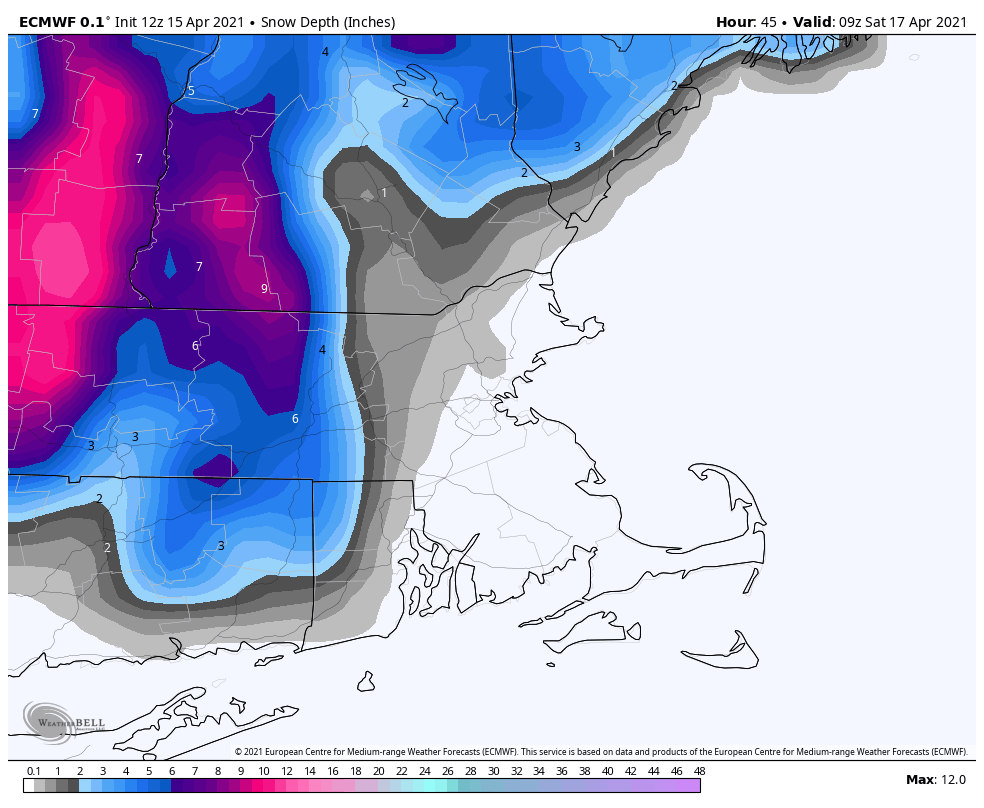
Low pressure is moving off the Mid-Atlantic coast this afternoon while an upper-level low pressure area moves in from the west. The upper-level low will draw the surface low northward towards southeastern New England while it intensifies. Rain is spreading across the region this afternoon, and it will become steadier and heavier tonight as the low moves up the coast. With the upper-level low moving in, we’ll have some very cold air aloft. As the rain becomes heavier, it will pull the cold air down from above, a process called “dynamic cooling”. As this occurs Friday morning, we’ll see the rain change over to snow across the hills from northwestern Rhode Island and central Massachusetts into southwestern New Hampshire. Some wet snow may mix in across the lower elevations of southern New Hampshire and northern Massachusetts as well but we’re not expecting much, if any, accumulation, and what does accumulate will be mainly on grassy surfaces because the pavement is too warm, and air temperatures won’t drop below freezing. It’ll be a different story across the hills from Worcester County into the Monadnocks of southwestern New Hampshire, where several inches may accumulate. Even heavier snow is possible for the Berkshires and the Green Mountains of Vermont. We should note that there are some models that are forecasting accumulating snow, and in some cases quite a bit of it, across most of eastern Massachusetts and Rhode Island. While we can’t completely rule out this scenario, we’re not expecting it to occur.
The surface low will pass near or over Cape Cod or southeastern Massachusetts Friday afternoon, allowing any mixed precipitation to change back to all rain and milder air moves in. The rain will taper off to showers in the afternoon, but the showers may not completely end until early Saturday as the system slowly starts to move away. Given the recent lack of rainfall, we’re starting to see drought conditions develop. With 1-2 inches of rain expected from this storm, we’ll help put a nice dent in that developing drought.

Saturday won’t be quite as chilly as Friday, but we probably won’t see much sunshine either as the system only slowly moves away. High pressure starts to build in on Sunday with more clearing and milder temperatures. However, an upper-level disturbance will be moving through, so a couple of pop-up showers can’t be ruled out. Patriots Day on Monday is shaping up to be a nice Spring day with partly sunny skies and mild temperatures, but again, a pop-up shower can’t be ruled out as another weak upper-level disturbance crosses the region.

Thursday night: Periods of rain, possibly heavy at times, changing to snow across the hills from northwestern Rhode Island and central Massachusetts into southwestern New Hampshire, breezy. Low 33-40.
Friday: Windy with rain mixed with snow at times in the morning, tapering off to showers during the afternoon. High 37-44, possibly a little warmer south of Boston.
Friday night: Cloudy and breezy with showers ending. Low 33-40.
Saturday: Plenty of clouds, possibly a few showers near the coast, some sunny breaks may develop in the afternoon. High 44-51.
Saturday night: Partly to mostly cloudy. Low 32-39.
Sunday: Intervals of clouds and sunshine, slight chance for a shower. High 49-56.
Sunday night: Clear to partly cloudy. Low 33-40.
Monday: Partly sunny, slight chance for a shower. High 56-63.
