We can sum up much of the upcoming week in one word: Awful. Yeah, it’s gonna suck. Let’s get right to the ugly details.
Showers will taper off this morning as a warm front stalls out near or just south of the region and a wave of low pressure riding along the front departs. However, with the front hanging out nearby, we’ll still have plenty of clouds, some drizzle and fog, and maybe another shower or two. Depending on where the front stalls out, some milder air may move into the South Coast, but for most of us, it won’t be that mild. Of course, today’s shower activity is the opening act for what follows.

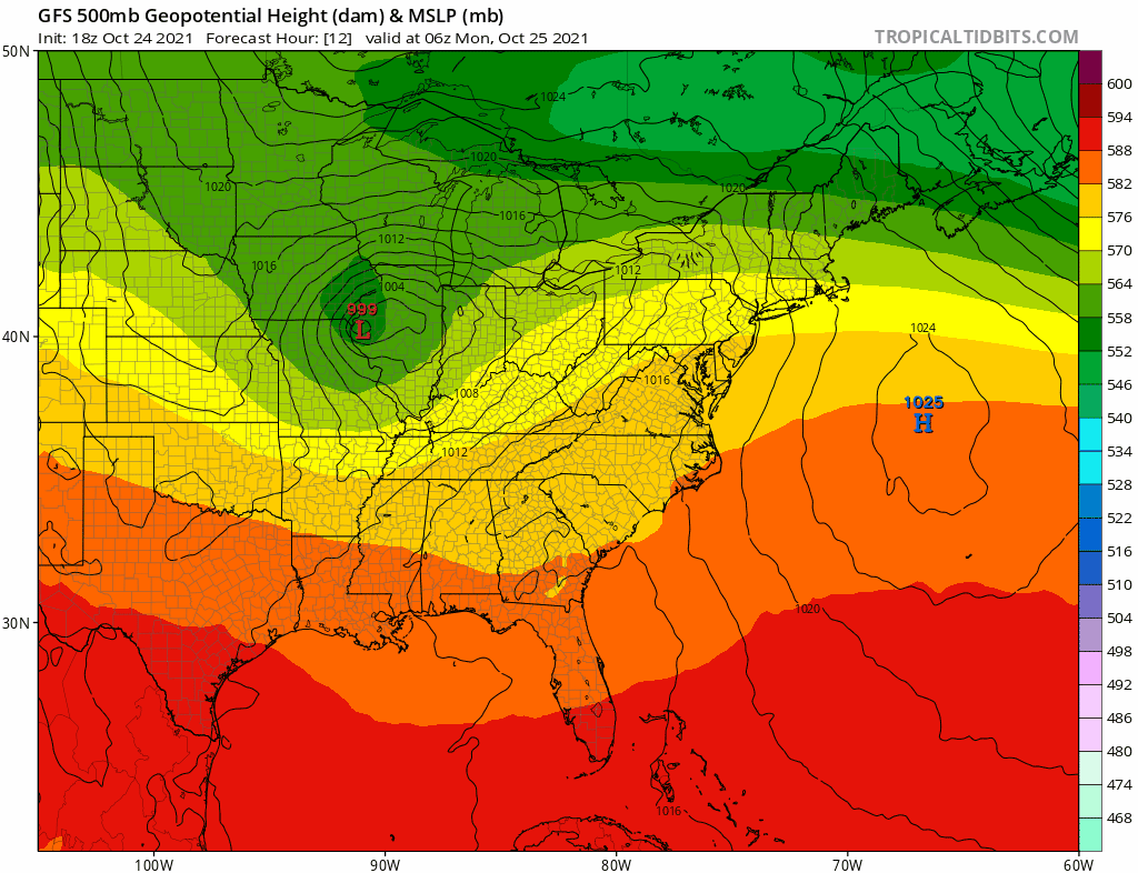
Our first coastal storm of the fall is on tap for Monday night into Wednesday, and possibly even early Thursday. A strong upper-level disturbance will move toward the East Coast from the Midwest while a second one moves out of the Gulf of Mexico. These two will meet up off the East Coast, resulting in an area of low pressure developing and rapidly strengthening south of New England. As an upper-level low pressure area also develops, it will capture the developing storm at the surface, which will prevent it from moving too much for about 24 hours. If it were late December or January, instead of late-October, this would likely be an impressive blizzard across the interior.
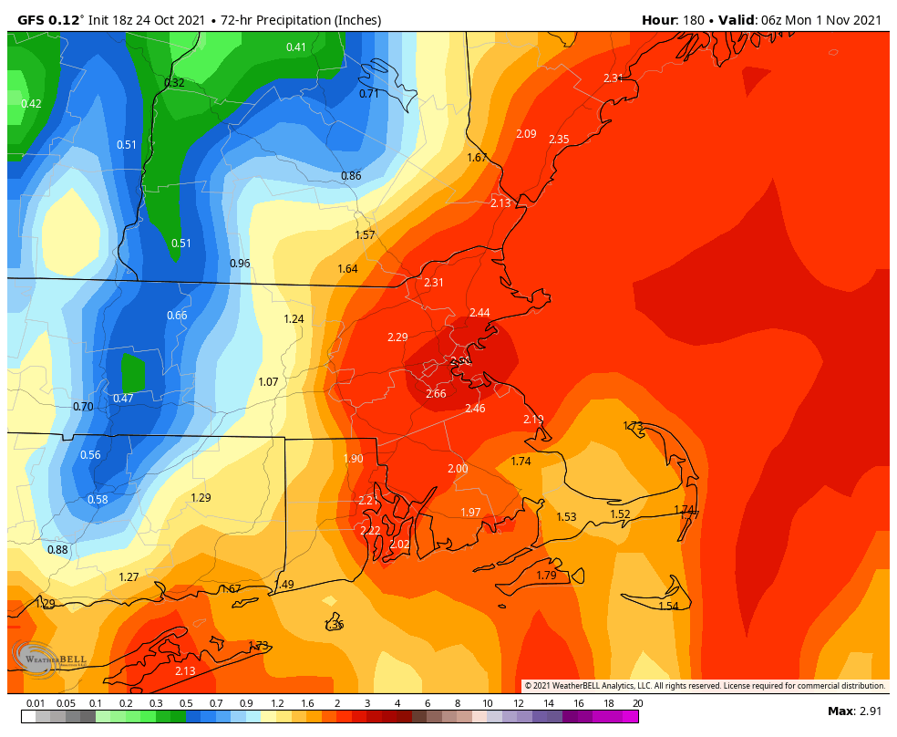
So what does all this mean for us? A lot. As in, a lot of rain and a lot of wind. Rain will redevelop Monday night, and continue into Wednesday, possibly heavy at times. Much of the region will likely receive 2-4 inches of rain, but many models are showing the potential for totals of 5-6 inches or more. As of the time of this writing, there were Flash Flood Watches in effect for southern Connecticut, but we expect them to be expanded into parts of Rhode Island and Massachusetts at least by Monday morning.

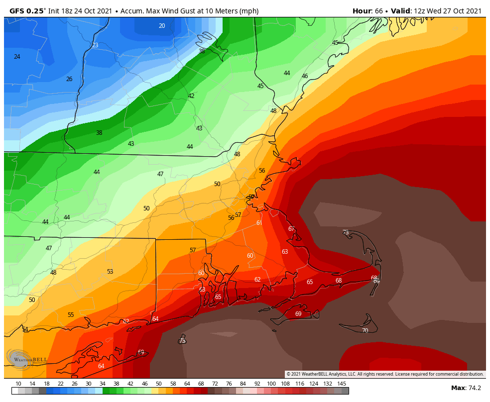
As for the wind, as the storm rapidly develops, the pressure gradient between it and the high pressure area to the north will result in increasing winds. As is usually the case, the strongest winds will be found along the coast, but even inland locations, especially across eastern Massachusetts and Rhode Island, will feel the winds. Northeast winds will be sustained at 25-35 mph, with gusts to 60 mph or higher expected. The strongest winds are likely from Tuesday morning into Wednesday afternoon, when a High Wind Watch is in effect. The combination of strong winds, heavy rain, and trees that still have most of their leaves will increase the threat for power outages, so charge up your electronics today just to be safe. As the leaves all come down, there are two other issues to worry about. First, they will clog up some of the storm drains, resulting in additional flooding, but they’ll also result in slippery roads, so keep this in mind if you’re out driving.
The storm system finally pulls away on Thursday, but winds may remain gusty, and a few lingering showers are also possible, especially across Cape Cod in the morning. High pressure builds in with some clearing and drier air later Thursday and Thursday night. Then things are nice for Friday and the weekend, right? Yeah, not so much. Another low pressure system will move out of the Midwest while an upper-level low pressure area also moves eastward. That means more rain developing at some point later Friday, and continuing off and on through the weekend. This storm shouldn’t be as potent as the one on Tuesday, so we probably won’t have as much wind or rain, but the weekend isn’t looking that great right now, and this includes trick-or-treating weather Sunday evening. Right now, the models have this storm a lot further north than the first storm, which would result in milder temperatures. There’s still a lot of uncertainty with this part of the forecast, so maybe it won’t be that bad (yeah, right). We should have a better idea what to expect when we get to our Weekend Outlook on Thursday.
Monday: Cloudy and breezy with showers tapering off in the morning, with periods of drizzle and possibly another shower or two in the afternoon. High 48-55 north and west of I-95, 55-62 south and east of I-95, except 62-79 south of Route 44.
Monday night: Breezy with Rain likely. Low 43-50 north and west of Boston, 50-57 south and east.
Tuesday: Very windy with rain, heavy at times. High 50-57 north and west of Boston, 57-64 south and east.
Tuesday night: Periods of rain and showers, very windy. Low 44-51.
Wednesday: Mostly cloudy and breezy with more showers likely. High 50-57.
Thursday: A lingering shower or two across Cape Cod early, some sunshine develops in the afternoon, especially north and west of Boston, still breezy near the coast. High 51-58.
Friday: Some early sun, then clouds return, rain develops at night, breezy. High 52-59.
Saturday: Periods of rain and showers. High 57-64.
Sunday: Cloudy with more rain and showers possible. High 57-64.
