As has been the case for a few months now, most of the upcoming week will be dry across the region, but not all of it.
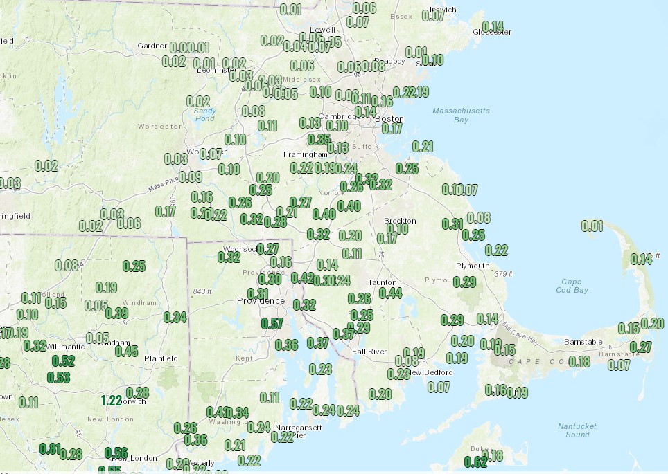
We did receive some beneficial rainfall across parts of Southern New England on Sunday, and it may linger into this morning, especially across parts of the Cape, before low pressure finally pulls away from the region. However, an upper-level disturbance will move through later today, and it may kick off a few additional showers or even a thunderstorm. This won’t be a widespread beneficial rain, but every little bit helps to alleviate the drought.
High pressure builds in on Tuesday, and remains in place through Friday, with generally dry and seasonably warm conditions expected. Humidity levels will remain comfortable as well, with dewpoints generally in the 50s.
Clouds start to move back in on Saturday and humidity levels start to rise as a cold front approaches from the west. This front will likely produce some showers and thunderstorms later Saturday into Sunday, but the timing will depend on how quickly the front actually crosses the region. We’ll nail down those details in our Weekend Outlook on Thursday.
Monday: Early clouds and a few showers, then becoming partly sunny with a chance for a few late-day showers. High 73-80, coolest along the coast.
Monday night: Mostly cloudy with some more showers possible, mainly during the evening. Low 59-66.
Tuesday: Becoming partly to mostly sunny. High 77-84.
Tuesday night: Clear to partly cloudy. Low 56-63.
Wednesday: Sunshine and some afternoon clouds. High 76-83.
Thursday: Plenty of sunshine. High 77-84.
Friday: Mostly sunny. High 79-86.
Saturday: Partly sunny, chance for some afternoon and evening showers and thunderstorms. High 82-89.
Sunday: A mix of sun and clouds, chance for some showers and thunderstorms. High 78-85.
