Much of this week will feature typical summer-time weather in New England, with warm to hot temperatures, humidity levels ranging from somewhat comfortable to not very comfortable, and some pop-up showers and thunderstorms.
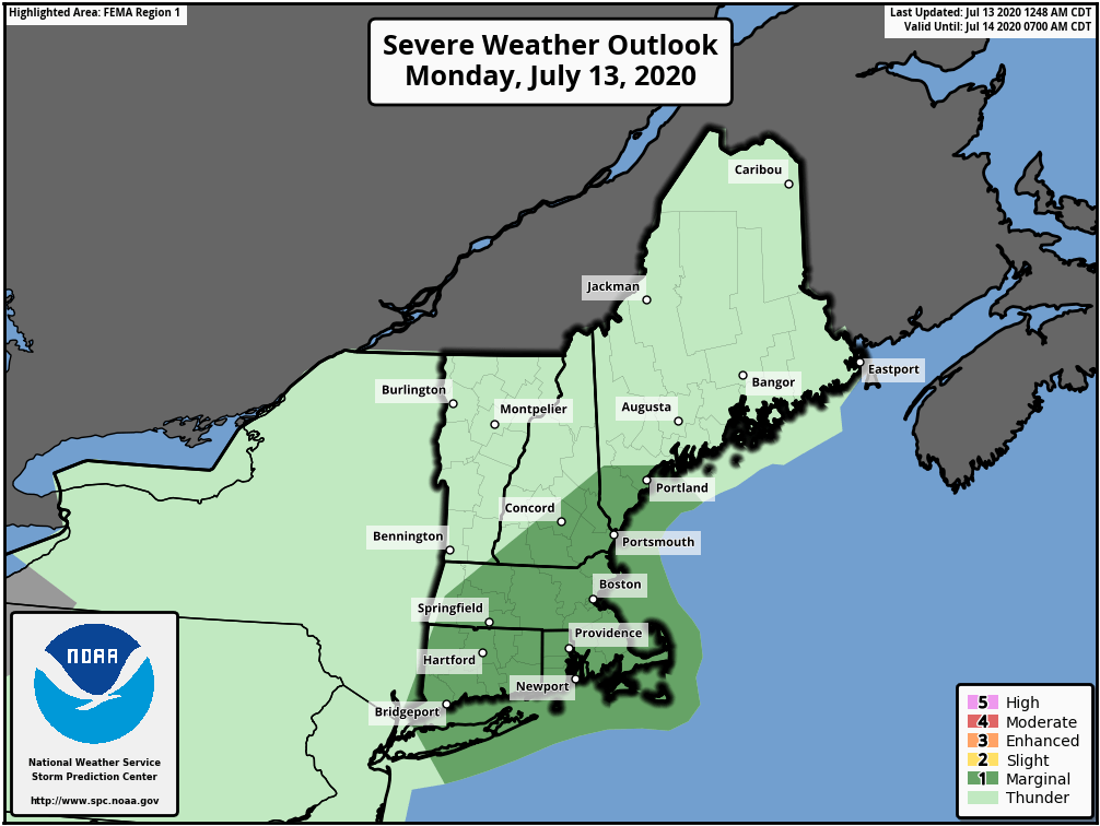
The week starts off with the most active weather day as a cold front starts to approach the region. A few showers are likely this morning as an upper-level disturbance swings through, but we should see some sunshine develop by midday. How much sunshine we get will help determine how much the atmosphere will destabilize again in the afternoon. As the front moves in from the west, showers and thunderstorms will develop. Many of these storms will produce heavy downpours, and some could redevelop over the same locations, resulting in some flash flooding. Depending on how much sun we see in the late morning and early afternoon, we could be looking at some severe storms, with strong winds and hail as well. There is even a slight chance for a tornado to form. How quickly the front moves will also help determine how long we’ll be dealing with the storms, and what areas have the best chance to have them. Right now, it looks like most of the storms will be during the 1pm-8pm time frame.

The front moves offshore tonight, and cooler and drier air starts to settle in. However, an upper-level low pressure area will be moving in at the same time. As this upper-level low moves right across New England on Tuesday, it will help produce another round of showers and thunderstorms during the afternoon. Most of these shouldn’t be strong, but with a pool of cold air aloft, we could see some small hail in a few of them.
The upper-level low moves offshore for Wednesday, and we’ll be under the influence high pressure for Wednesday and Thursday, with sunshine, seasonably warm temperatures (tempered by a seabreeze along the coast), and moderate humidity levels. Warmer and more humid air moves in for Friday and the weekend. A series of weak upper-level disturbances will also move across the region, creating a daily chance for showers and thunderstorms.

Monday: A few showers early, then becoming partly sunny. Showers and thunderstorms are likely during the afternoon and evening. Some of them may produce heavy downpours. High 82-89.
Monday night: Showers and thunderstorms end during the evening, then skies clear out. Low 62-69.
Tuesday: A sunny start, then clouds develop with a few showers and thunderstorms likely during the afternoon. High 76-83.
Tuesday night: Clear to partly cloudy. Low 59-66.
Wednesday: Sunshine and a few clouds. High 72-79, coolest along the coast.
Thursday: Some patchy morning fog, then becoming partly to mostly sunny. High 74-81, coolest along the coast.
Friday: Intervals of clouds and sunshine with some showers and thunderstorms possible, especially during the morning, a little more humid. High 77-84.
Saturday: Partly sunny, chance for a shower or thunderstorm. High 83-90, cooler along the coast.
Sunday: A mix of sun and clouds, a shower or thunderstorm is possible. High 86-93.
