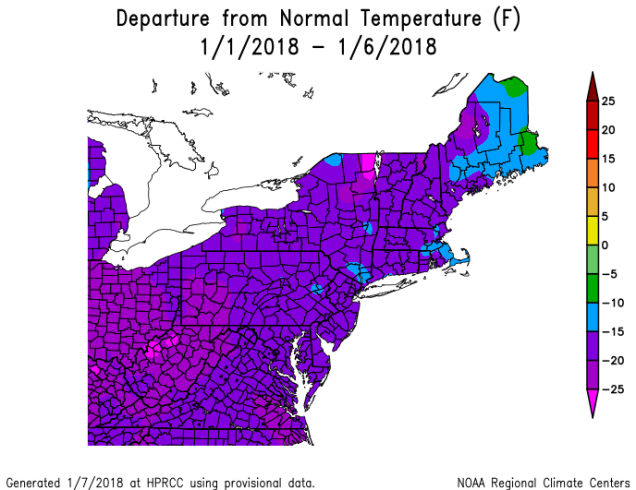
So, has the past week been cold enough for ya? Don’t worry, the cold air is finally departing, and we’ve even got some actual mild air in the forecast. We’ve also got the potential for a wintry mess too, so let’s get to the details.
The week starts off with clouds and some snow showers (rain showers across Cape Cod) ahead of a cold front. Don’t worry, we’re not expecting much (if any) accumulation, but the bigger story will be temperatures actually getting into the 30s across the area. It’s going to feel downright balmy compared to the past week. The front moves through tonight, and the snow or rain showers end. High pressure builds in for Tuesday and Wednesday with drier conditions, but temperatures will remain close to where they should be in early January. After that, we jump on a bit of a rollercoaster.
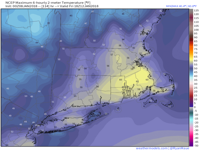
Low pressure will head into the Great Lakes on Thursday while high pressure moves offshore. This means southwest winds will bring unseasonably mild air into the region. Temperatures will get well into the 40s in many locations. We’ll have plenty of clouds, but will anyone care with those temperatures? We didn’t think so. Friday looks to be even warmer, with upper 40s and 50s for much of the region, possibly even close to 60 if you believe one model (see below). It’ll be accompanied by rain and gusty winds, but again, is anyone going to care? It’s going to be mild!
Saturday is where we get to the real problems. As that initial system moves by, a cold front trailing it will move towards the region while another system moves towards the Northeast from the Tennessee Valley. The question is, and it’s a fairly important one, when does that cold front move through the area? One model says that it waits until Sunday morning, so Saturday would be another warm, but wet day. Another model brings the front through on Saturday, with cold air rapidly moving in, which means that we could have some freezing rain or a cold rain to deal with across much of the area. So we could be in the 50s and raining, in the 20s with freezing rain, or somewhere in between. That’s a wide variety of options, and at this point, we’re not sure which way to go. Complicating matters is the fact that the Patriots play the Titans in a playoff game in Foxboro that evening, so the weather could impact the game. Things should start to get a little more clear as the week goes on. Conditions should improve on Sunday, behind the system.

Monday: Cloudy and breezy at times with a few snow or rain showers possible. High 30-37.
Monday night: Mostly cloudy, some clearing takes place late at night. Low 22-29.
Tuesday: Becoming partly to mostly sunny and breezy. High 33-40.
Tuesday night: Clear skies. Low 10-17.
Wednesday: A sunny start, then skies cloud up in the afternoon. High 31-38.
Thursday: Mostly cloudy and milder with a chance for a few showers. High 44-51.
Friday: Breezy and mild with periods of rain likely. High 50-57.
Saturday: Mostly cloudy with a chance of……something. Quite frankly, that’s about the only thing we’re certain of at this point.
Sunday: Clearing, breezy, and colder. High 29-36.
