A warming trend is on the way for the weekend, but possibly some rain as well.
After a rather chilly start to the day, temperatures have moderated as high pressure moves offshore. Temperatures will continue to warm up into Friday and Saturday, though as the high moves off to our north and east, winds will shift into the northeast, allowing cooler air to slide back in later on Saturday and into Sunday.
Temperatures bottomed out in the middle teens to middlle 20s across most of the region this morning. Image provided by NOAA.
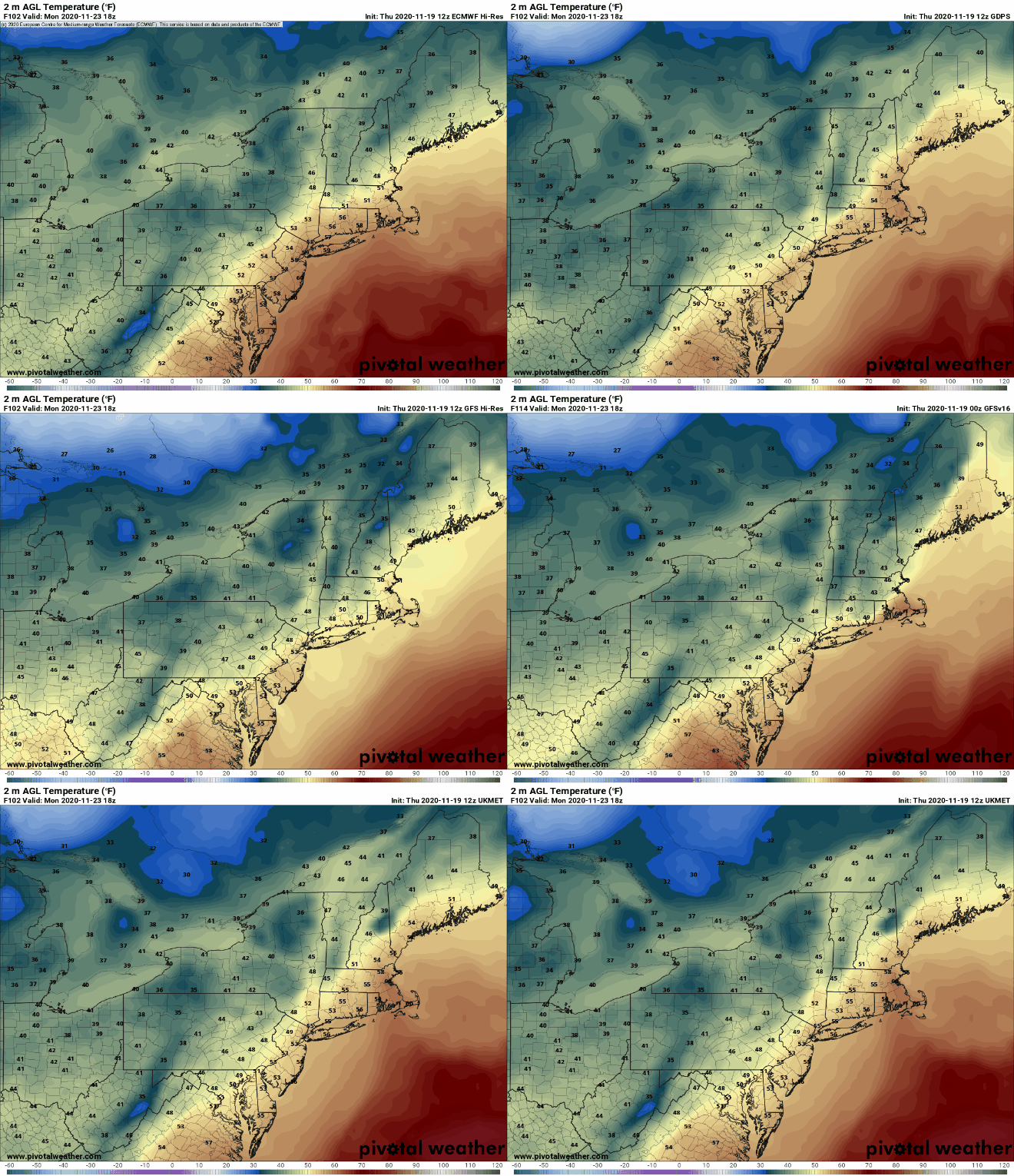
By later on Sunday, a warm front will move toward the region. Whether or not it makes it all the way through is still a question mark, but parts of the region, especially south of Boston, should see milder air move in for a while on Monday. The milder air will be preceded by some showers Sunday night and early Monday ahead of a cold front. While this won’t be drought-busting rainfall, every little bit helps at this point.
The models don’t agree on how far north the warm air will get on Monday. Images provided by Pivotal Weather.
Thursday night: Partly cloudy. Low 35-42.
Friday: A mix of sun and clouds, breezy. High 53-60.
Friday night: Clear to partly cloudy. Low 39-46.
Saturday: Partly sunny. High 52-59.
Saturday night: Clear to partly cloudy, some low clouds, fog, and drizzle are possible along the coast. Low 27-34.
Sunday: Becoming mostly cloudy. High 42-49.
Sunday night: Showers likely, maybe mixed with a little sleet or wet snow at the start up into central New Hampshire. Low 34-41.
Monday: Showers end early, skies may clear out in the afternoon, breezy. High 53-60, possibly a little cooler in southern New Hampshire.
After several days of sunshine and record-breaking warmth, we’re going to be dealing with cooler conditions and some wet weather at times in the next few days. In other words, welcome to November.
November is off to a very warm start across the Northeast. Image provided by the Northeast Regional Climate Center.
Our record warmth is now a memory as a cold front has moved across the region. That front will stall out just to the south tonight, and a wave of low pressure will ride along it on Friday, bringing us some more showers as cooler air continues to settle into the area. Temperatures on Friday will be 25-30 degrees colder than they were on Wednesday.
Average high temperatures for mid-November are in the lower 50s across the area. Image provided by Weathermodels.com
High pressure builds in on Saturday with sunshine and temperatures that are more representative of mid-November. Sunday will start off dry, but another cold front will be approaching the region. We should turn milder again ahead of that front, but not nearly to the extent of what we’ve had for the past week. Showers are likely Sunday night into Monday morning as the front moves through. We’ll dry out and turn breezy and cooler again Monday afternoon as that front pushes offshore.
Thursday night: Cloudy with some patchy drizzle and a few showers. Low 37-44.
Friday: Scattered showers. High 46-53, possibly a little cooler north and west of 495.
Friday night: Clearing. Low 32-39.
Saturday: Mostly sunny. High 44-51.
Saturday night: Clear to partly cloudy. Low 26-33.
Sunday: Some morning sun, then clouds move in during the afternoon with showers possible toward evening. High 52-59, possibly cooler in southern New Hampshire.
Sunday night: Cloudy and breezy with showers likely, ending before daybreak. Low 37-44.
Monday: Partly to mostly sunny and breezy. High 47-54.
This will likely be the shortest update we’ve ever written. High pressure remains in control right through the weekend and into the start of next week with generally fair weather and unseasonably mild temperatures.
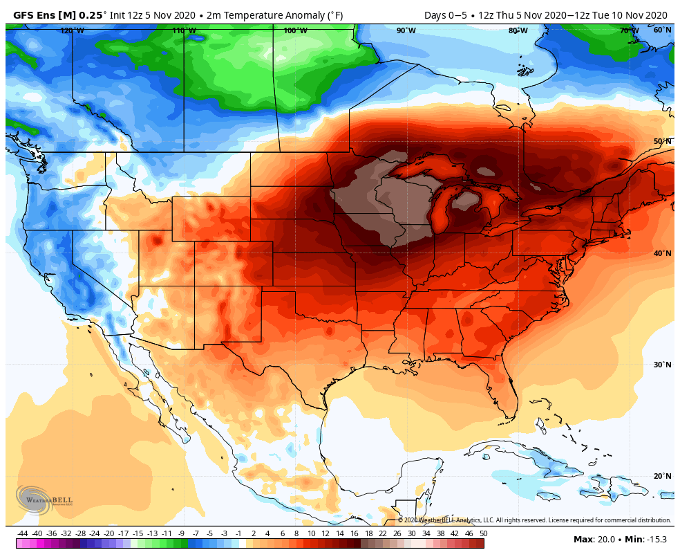
While it’s quite mild here, temperatures will be as much as 20 degrees above normal across the Midwest this weekend. Image provided by WeatherBell.
Thursday night: Partly to mostly cloudy. Low 47-54.
Friday: Becoming mostly sunny, a little breezy at times. High 64-71.
Friday night: Clear to partly cloudy. Low 44-51.
Saturday: Sunshine and some high clouds. High 65-72.
Saturday night: Clear skies. Low 41-48.
Sunday: Plenty of sunshine. High 63-70, a little cooler right along the coast.
We’ve got a little bit of everything coming up in the next few days, but that’s actually fairly typical for autumn.
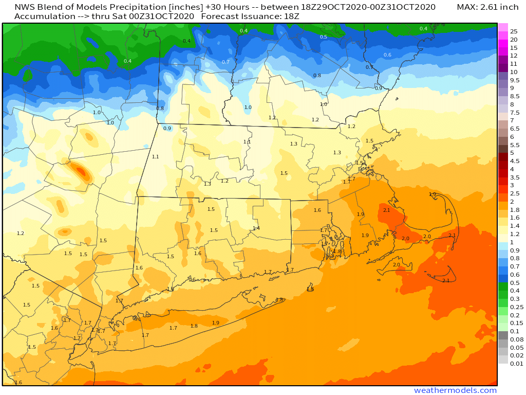
The weekend starts off on a stormy note as the remains of Zeta pull away tonight while a second system quickly follows. The heaviest rain is expected this evening and the first part of tonight from Zeta’s remains, but as it pulls away, it will draw some colder air into the region just as the second storm moves in. As that colder air moves in, we’ll see the rain mix with and change over to sleet and wet snow, first in the hills of southwestern New Hampshire and central Massachusetts early Friday morning, then across the rest of southern New Hampshire and eastern Massachusetts by daybreak or shortly thereafter. Everything should wind down by early afternoon, followed by rapid clearing and diminishing winds (more on this in a moment).
The rainfall tonight and early Friday will be beneficial and help put a dent in the ongoing drought. Image provided by Weathermodels.com
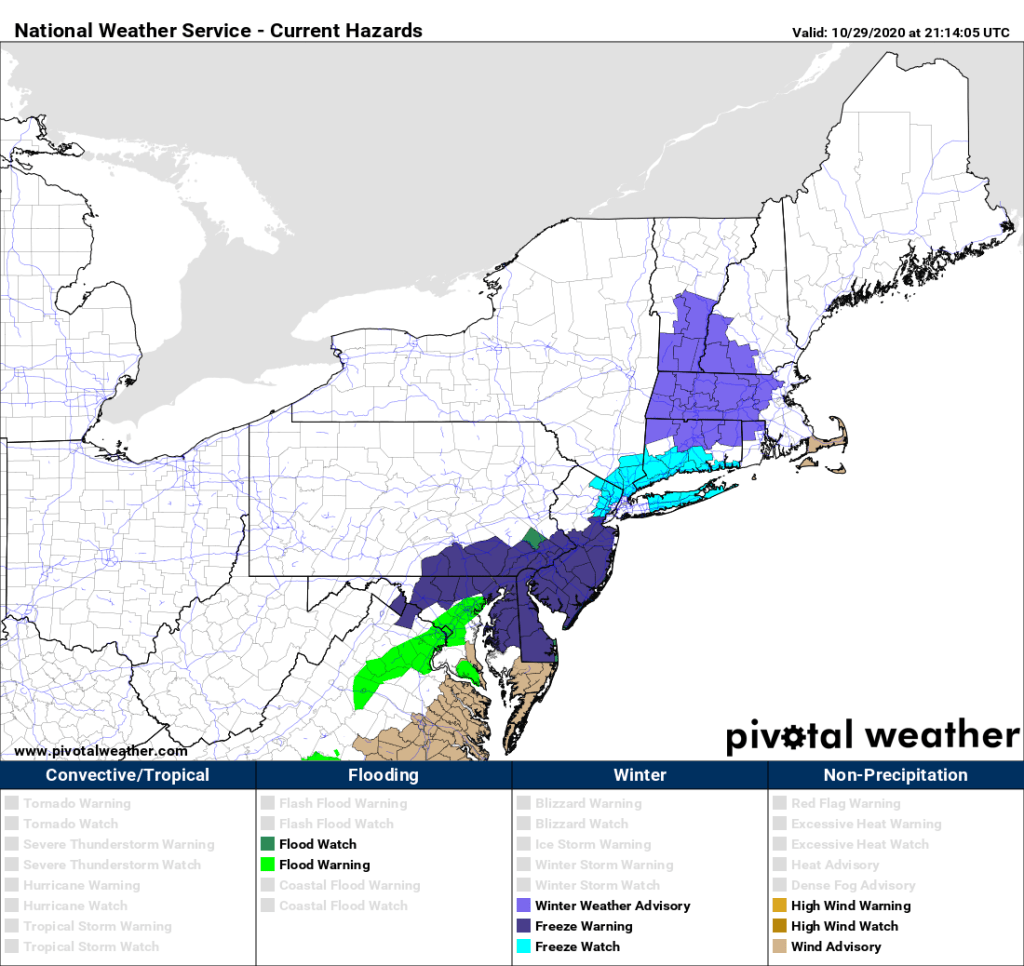
Since the National Weather Service has posted Winter Weather Advisories for the interior of the region, you must be expecting some decent snow, right? We don’t think so. Across the hills of Worcester County and the Monadnocks, a few inches may accumulate, possibly a little more on top of the hills. For Southern New Hampshire (Concord-Manchester-Nashua), you could see an inch or so, maybe two inches in a few spots, mainly on grassy surfaces. From the New Hampshire Seacoast into the Merrimack Valley of Massachusetts we’re looking at an inch or less, again mainly on grassy surfaces. For the rest of us, just a mix of rain or snow, maybe enough to coat the grass in some spots, mainly from Metro West to the North Shore.
Winter Weather Advisories have been posted for interior portions of New England. Image provided by Pivotal Weather.
Why is our forecast for less than most of the TV and NWS forecasts out there? Most of the forecast models are showing the potential for 1-3, possibly as much as 6 inches of snow. However, a lot of people seem to forget a few things. First, those maps assume a 10:1 ratio of snow to liquid (1 inch of rain equals 10 inches of snow). With temperatures near or just above freezing, the ratio won’t be 10:1, more like 7 or 8 to 1, so that trims to 20-30% off of the map totals. Second. the ground is still relatively mild. While this impact is minor, it just means that the snow won’t stick initially, as it will melt on contact until the ground cools a bit more. So that may take away another 10% of the model totals. Factor those into the model forecasts, and you arrive at the numbers we have.
Once the system pulls away, it will clear out as we mentioned before. Temperatures will drop quickly, likely bottoming out in the 20s across much of the region, maybe even upper teens in some spots. Any roads that are still wet during the evening may start to ice up, especially bridges, overpasses, and elevated roadways. Keep this in mind if you’ll be out Friday night or early Saturday morning. As for Saturday, it’ll be a rather chilly Halloween despite sunshine. High temperatures will only get up into the middle to upper 40s at best.
Temperatures will only be in the 30s Saturday evening, so make sure the kids are dressed properly for trick-or-treating. Image provided by WeatherBell.
Saturday night probably won’t be quite as cold, as winds will shift into the southwest and clouds will start to move in. Sunday will be milder, but with a cold front approaching, a few showers are possible during the afternoon and evening. Much colder air settles in behind that front on Monday, when temperatures will struggle to reach 40 in some spots. We may even see a few flurries. The good news is, it looks like it will start to warm up again later next week, but we’ll have more details on this on our Weekly Outlook Monday morning.
Most of next week should feature temperatures that are near or a little above normal for early November. Image provided by WeatherBell.
Thursday night: Breezy with rain, possibly heavy at times, gradually mixing with and changing over to sleet and wet snow. Low 30-37, except 37-44 across Cape Cod and the Islands.
Friday: Snow or a wintry mix ending around midday, then skies start to clear out with diminishing winds. High 34-41, a little warmer across Cape Cod and the Islands.
Friday night: Clear and chilly. Low 18-25, 26-33 across Cape Cod and the Islands.
Saturday: Sunny and cool. High 40-47.
Saturday night: Clear during the evening, clouds start to move in after midnight. Low 25-32, but temperatures may start to rise a bit after midnight.
Sunday: Cloudy with a few late-day showers possible. High 54-61.
Sunday night: Mostly cloudy, any showers end during the evening. Low 30-37.
Monday: A mix of sun and clouds, slight chance for a snow flurry or a sprinkle. High 39-46.
Temperatures will be riding a rollercoaster around here through the weekend, but as has been the case more often than not recently, little rainfall is expected.
Last week’s rain helped, but much of the region is still experiencing severe to extreme drought. Image provided by the National Drought Mitigation Center.
We’re starting off with a sunny and warm afternoon, but high pressure building in tonight will result in some cooler weather for Friday, as winds shift into the east. There may be a little patchy fog again tonight, but otherwise, we’ll have generally clear to partly cloudy skies into Friday.
That high will slide off to our east on Saturday, allowing us to warm back up, but clouds will also be streaming in ahead of a cold front. That cold front will move through during the afternoon, but it will be starved for moisture, so other than a spot shower or two, it should remain dry. However, you will notice the front in the temperature department. Temperatures could approach 70 during the afternoon, but will start to drop pretty quickly behind the front. By Sunday morning, many of us will see temperatures in the 30s to lower 40s. With high pressure building back in on Sunday we’ll have some sunshine, but north to northeast winds will keep temperatures in the upper 40s and 50s all afternoon.
After several mild nights, Sunday morning will be much cooler. Image provided by Weathermodels.com
We start heading back up the rollercoaster on Monday as low pressure passes north and west of the region, bringing a warm front through. This will allow us to warm up again, but it may also bring in some showers. They shouldn’t be too heavy or widespread, but at this point, any rain helps with our current drought. As the low moves by, it will drag a cold front through towards evening, with a few more showers possible, and sending temperatures downward again as we head into next week.
Little rainfall is expected between now and Monday evening. Image provided by WeatherBell.
Thursday night: Clear to partly cloudy with some patchy fog developing. Low 48-55.
Friday: A mix of sun and clouds. High 62-69.
Friday night: Partly to mostly cloudy, more fog is possible. Low 46-53.
Saturday: More clouds than sun, breezy late in the day, slight chance for a shower. High 65-72.
Saturday night: Clearing. Low 34-41.
Sunday: Sunshine and a few clouds, much cooler. High 47-54.
Sunday night: Becoming mostly cloudy. Low 36-43.
Monday: Cloudy with a chance for some showers. High 56-63.
After a good soaking a few days ago, we have more rain in our future.
Enjoy today’s weather, because things will be quite different tomorrow afternoon. Loop provided by the College of DuPage.
We’ve got a breezy and mild day in progress today, but changes are coming. Clouds will start to stream into the region tonight as a cold front approaches from the west. Showers will develop ahead of this front on Friday, making for a rather damp day. By late in the day, as the front moves into eastern New England, a wave of low pressure will ride along it from the south, bringing in some steadier and heavier rainfall at night. The models still disagree on how much rain we’ll actually get, but they all have come down significantly from the projected totals earlier this week of 2-3 inches, as expected. In fact, it wouldn’t be a surprise if parts of eastern Massachusetts receive less than 1 inch of rain from this system.
A decent slug of rainfall is on the way for the region. Image provided by WeatherBell.
The front pushes offshore Saturday morning, bringing an end to the rain. We’ll start to clear out behind the front during the afternoon, but it will be breezy and cool. High pressure then builds in for Sunday into Monday with dry and seasonably cool conditions.
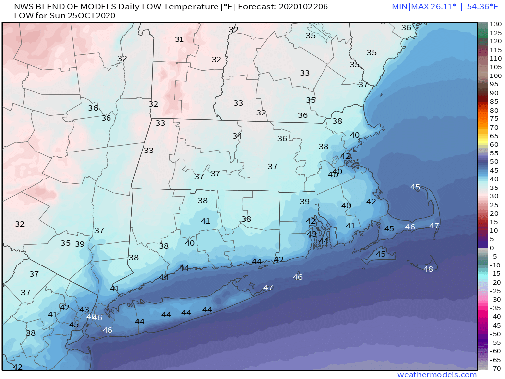
It might be on the chilly side if you’re up early Sunday morning. Image provided by Weathermodels.com
Thursday night: Increasing clouds. Low 53-60.
Friday: Cloudy and breezy with showers developing by midday. High 64-71, but temperatures may drop quickly in the afternoon.
Friday night: Cloudy with periods of rain and showers, some of the rain may be heavy. Low 40-47.
Saturday: Rain ending in the morning, then becoming partly to mostly sunny and breezy. High 51-58.
Saturday night: Clear to partly cloudy. Low 33-40, a little warmer in urban areas and right along the coast.
We’ve reached Columbus Day Weekend, or for our friends north of the border, it’s Thanksgiving Weekend. For one day at least, it’s not going to feel like it.
Friday morning will be rather chilly across the region. Image provided by Weathermodels.com
Once again, we’ve got a fairly simple forecast for the most part. High pressure remains in control through Saturday. This provides us with cool weather into Saturday. Frost advisories are in effect away from the coastline tonight, as temperatures will drop into the 30s in many areas. If you still have anything in your garden, it’s time to bring it inside. The high slides offshore Friday night, allowing milder air to move back in. In fact, Saturday will be quite warm, with temperatures reaching the 70s for most of us.
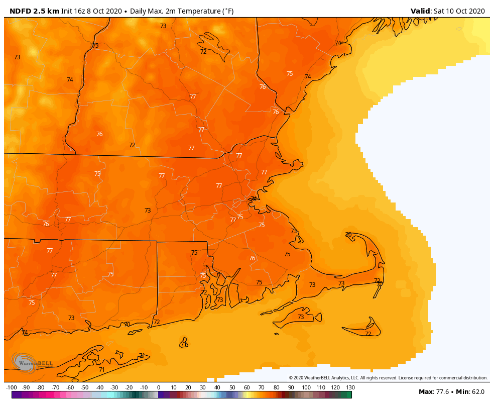
Saturday is definitely the better of the weekend days. Image provided by WeatherBell.
Sunday is when things start to change. A cold front moves through during the early morning, but there will be little precipitation accompanying it. There may be a few sprinkles or a spot shower, but the vast majority of the region should remain dry. However, much cooler weather will settle back in, with temperatures similar to today and Friday as high pressure builds back in behind the front.
This brings us to Monday, which is a bit of a question mark at this point. What’s left of Hurricane Delta will start moving this way in the form of some shower activity. The high pressure area will still be in control, keeping most of the shower activity from moving in. However, the high will be pushing off to the east, so right now, it looks like we may see some showers start to move in during the afternoon and evening. The day shouldn’t be a washout, and in fact, it may remain dry during the daylight hours. It will stay cool though with plenty of cloud cover.
Will some rain move in on Monday or not? The models don’t all agree on the outcome. Images provided by Pivotal Weather.
Thursday night: Clear and chilly. Low 33-40.
Friday: Sunny and cool. High 57-64.
Friday night: Partly cloudy. Low 44-51 during the evening, temperatures will start to rise a bit after midnight.
Saturday: A mix of sun and clouds, breezy, and warmer. High 71-78.
Saturday night: Partly to mostly cloudy, slight chance for a shower late at night. Low 50-57.
Sunday: More clouds than sun. High 59-66.
Sunday night: Plenty of clouds. Low 42-49.
Monday: A few sunny breaks early, otherwise mostly cloudy, showers may develop towards evening. High 56-63.
We’re into a new month, and some things will change, but some will remain the same this weekend.
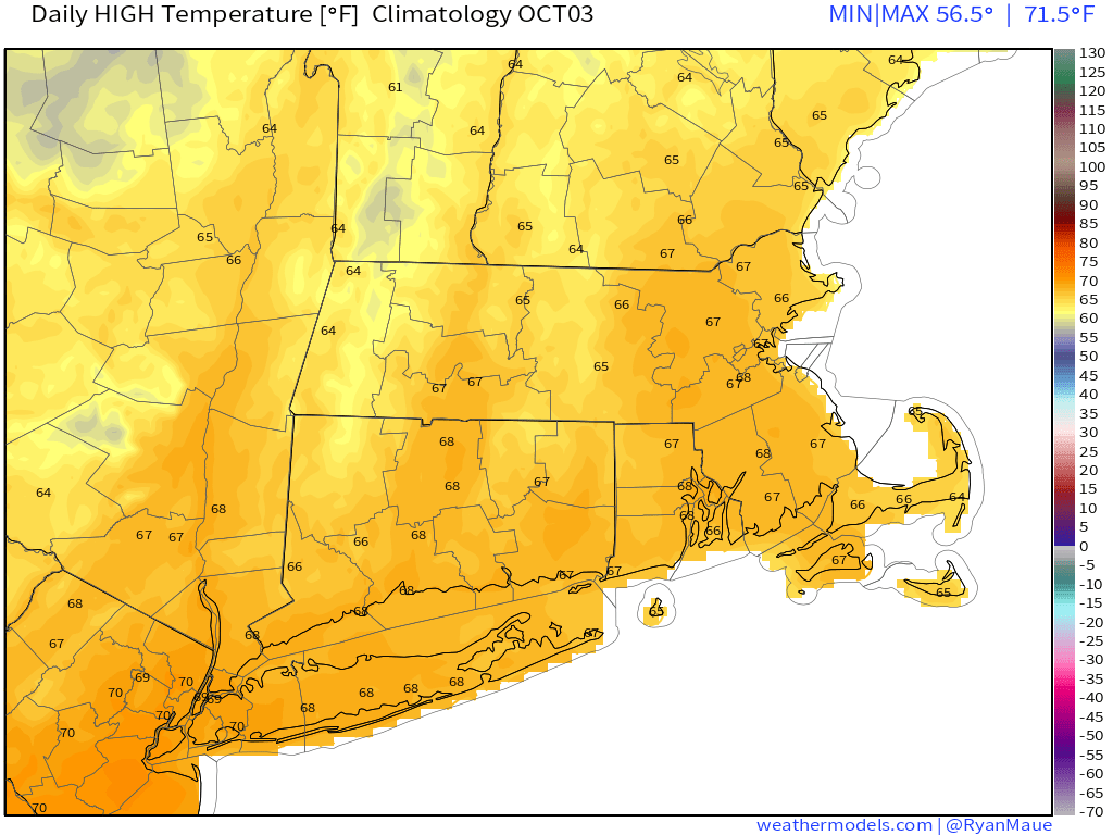
High temperatures are normally in the middle to upper 60s at the start of October around here. Image provided by Weathermodels.com
While we’re enjoying sunshine and warm temperatures this afternoon, the first changes are on their way. Clouds will stream in tonight ahead of a cold front. This front will bring some showers in on Friday, but like many of our recent systems, they’ll be fairly light, and won’t provide much, if any, help with our drought. Most of the activity will be north and west of Boston, with the possibility that it remains completely dry south and east of Interstate 95. It’ll be mild during the morning across eastern Massachusetts before the front moves through, but temperatures will likely drop during the afternoon.
Friday’s rainfall certainly won’t be a drought-buster. Image provided by WeatherBell.
High pressure builds in for the weekend with temperatures that are closer to normal, perhaps even a little below normal in spots. Sunday looks to be the better of the weekend days with plenty of sunshine. Saturday should still be a pretty good day, but a weak upper-level disturbance will help to trigger some clouds, especially during the afternoon. There may even be a few sprinkles or showers late in the day, mainly north of the Mass Pike. It’s nothing to worry about, but if you’ve got any outdoor plans during the afternoon and evening, don’t be surprised if there are a few raindrops.
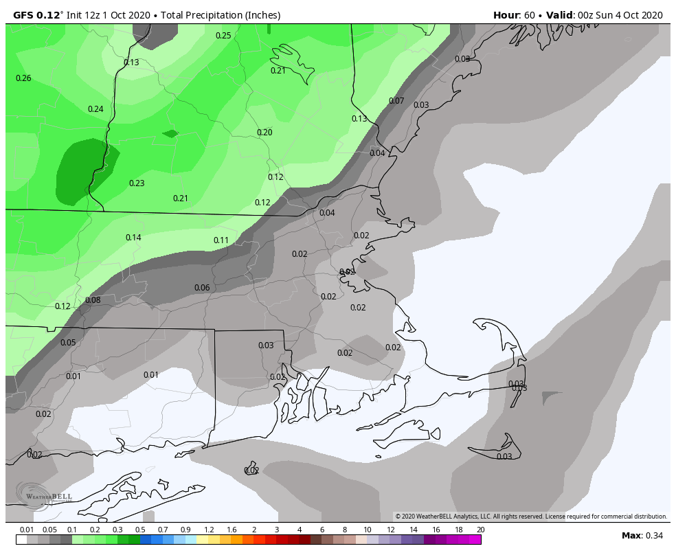
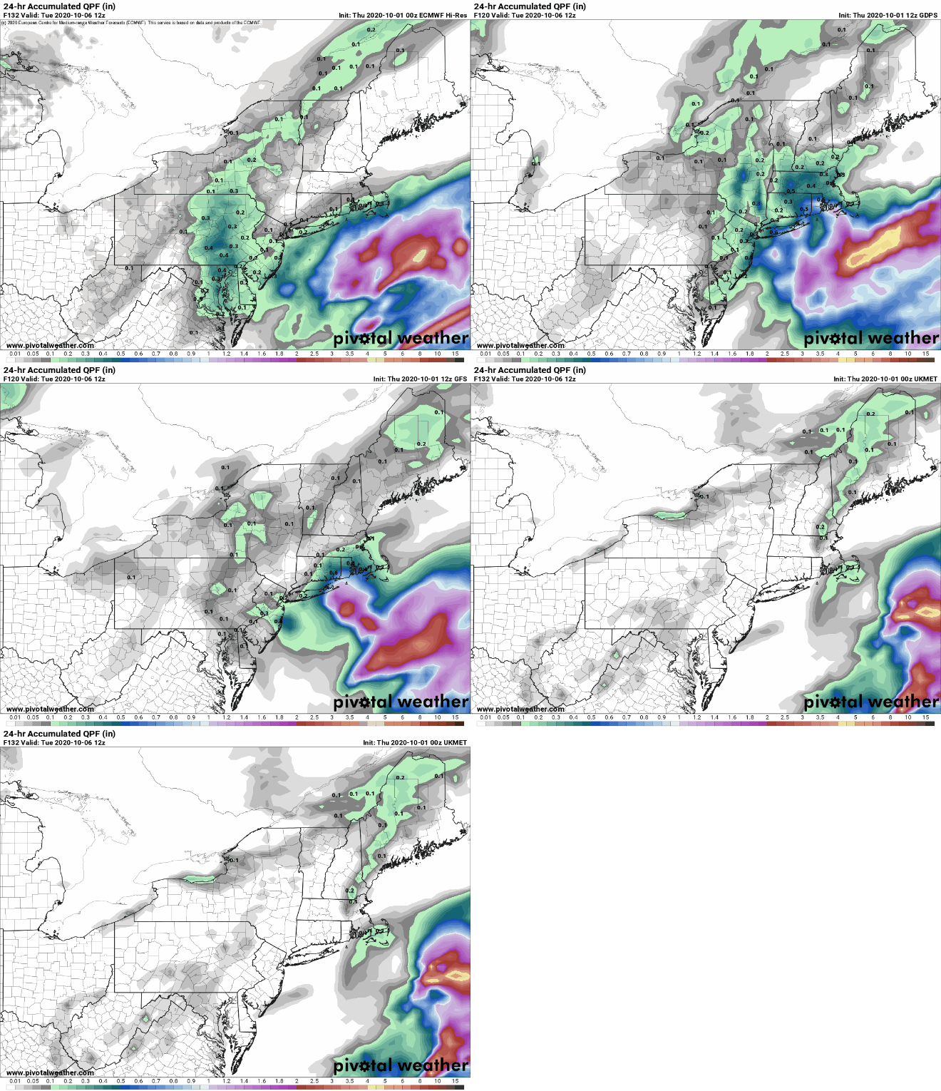
Monday brings more changes to the region. A storm system will likely bring some rain into the area as it passes to our south and east. How far north and west the rain shield extends, and how heavy the rain will be are still a bit uncertain. It looks like the heaviest rain should stay offshore, but it wouldn’t be a complete surprise if we get some steadier rain into the Cape and Islands and possibly southeastern Massachusetts. It also could be a bit breezy in these locations as well, again depending on how close the storm actually gets to the region. We’ll obviously have much more clarity on this in our Weekly Outlook early Monday morning.
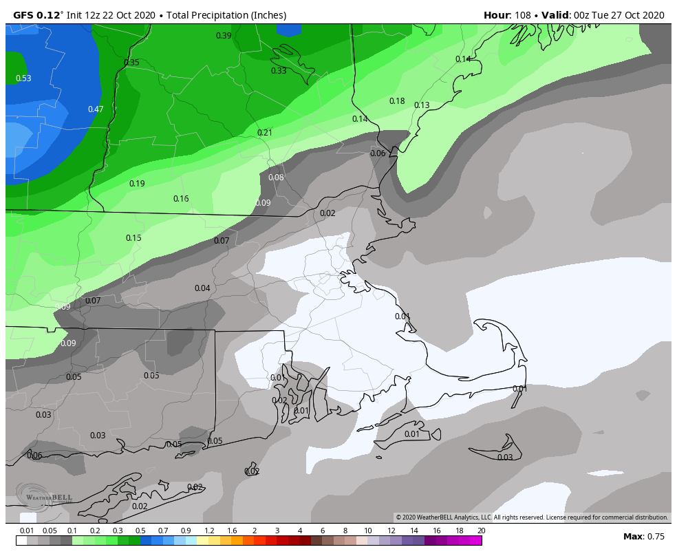
There is disagreement among the models as how to much rain we get on Monday. Images provided by Pivotal Weather.
Thursday night: Increasing clouds. Low 49-56.
Friday: Cloudy with some showers likely. High 59-66, a little warmer across eastern Massachusetts during the morning.
Friday night: Becoming clear to partly cloudy. Low 40-47, a little warmer in the urban areas.
Saturday: Partly sunny with a slight chance for a few late-day sprinkles or showers. High 61-68.
Saturday night: Clear skies. Low 40-47.
Sunday: Sunshine to start, some clouds start to move in late in the day. High 60-67.
Sunday night: Becoming mostly cloudy with showers possible by daybreak. Low 44-51.
Monday: Cloudy with a chance of showers, possibly some steadier rain across the Cape and Islands. High 57-64.
Fall is officially here, but it certainly won’t feel like it through most of the weekend.
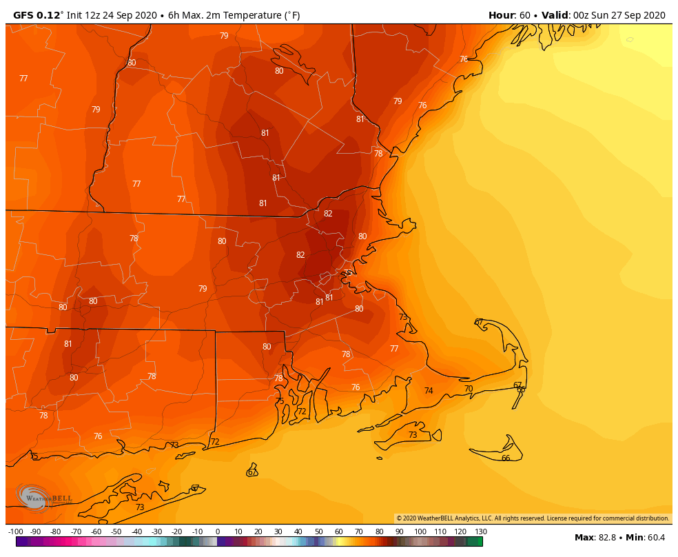
High pressure keeps us dry through Sunday. Unlike the last several days, we will be much warmer, thanks to west to southwest winds. In fact, by Sunday, it may even feel humid once again. It’s not going to be the Dog Days of summer, but highs in the upper 70s to lower 80s and dewpoints in the middle 60s aren’t too typical of the final weekend of September.
While it’s looking dry, it probably won’t be completely sunny through the weekend. What’s left of Tropical Storm Beta will be passing to our south Saturday. It may spread some clouds into the region, but for now, it looks like most of the rain will stay south of us, though a few of the models do try to sneak some showers in on Saturday. Since it’s been very dry lately, and we’re still in a drought, we’re going to follow the old forecaster’s adage “When in drought, leave it out.”
Virtually no rain fell over the past week, worsening drought conditions across New England. Image provided by the National Integrated Drought Information System
By Sunday night, things start to change. A large upper-level trough of low pressure will settle into the Great Lakes. At the surface, a cold front will move toward the region. Some showers are likely ahead of this front Sunday night into Monday. This isn’t a drought-busting rain by any means, but every little bit helps. A cooler, more unsettled pattern may settle in for next week, but the details aren’t that clear yet. We’ll focus more on that in our Weekly Outlook early Monday morning.
Thursday night: Partly cloudy. Low 52-59.
Friday: Sunshine and a few clouds. High 74-81.
Friday night: Clear skies. Low 53-60.
Saturday: Partly to mostly sunny. High 75-82.
Saturday night: Partly cloudy. Low 57-64.
Sunday: Partly sunny, breezy, and warm. High 76-83.
Sunday night: Mostly cloudy with showers developing. Low 60-67.
Monday: Plenty of clouds with scattered showers likely, breezy. High 72-79.
Astronomical fall officially begins Tuesday morning at 9:31am. As far as the weather is concerned, fall is going to start tomorrow.
Temperatures are going to turn much cooler, but we’re still not expecting much, if any, rain for the next several days, so our drought situation will continue to get worse. A cold front will move across the region tonight, but it will be starved for moisture, so aside from a few very widely scattered showers, we’re not expecting any rain for most of us. There may be a few appreciable showers along the South Coast and across the Cape, but for the rest of us, you’ll probably be able to count the number of raindrops that fall on one hand.
Little to no rainfall is expected through Monday. Image provided by Weathermodels.com
After that, high pressure starts to build in behind the front on Friday and remains with us right through the weekend. This will give us plenty of sunshine for Saturday, Sunday, and Monday, but it will remain on the cool side. Some places may not even reach 60 during the afternoons. What about at night? If you’ve got some plants outside, or still growing in the garden, it’s time to bring them inside. There’s a good shot at the first frost for portions of the region. Welcome to Autumn.
Saturday morning looks quite cool, but Sunday morning could be a few degrees cooler. Image provided by WeatherBell.
Finally, we’ll briefly talk about the tropics, though we’re expecting to write a much more detailed post about them tomorrow. What’s left of Sally will bring heavy rain to the Carolinas today, then move offshore, sending some clouds our way tonight and early Friday, but the rain should stay to the south. A disturbance in the western Gulf of Mexico may become a Tropical Depression later today or tomorrow. What impact it has on Mexico and/or Texas remains to be seen. Tropical Depression Vicky should dissipate in the Central Atlantic today or tomorrow. Then there’s Hurricane Teddy. Teddy is going to become a pretty powerful storm in the next day or two. The current track brings it very close to Bermuda early Monday. Bermuda just got hit hard by Paulette, and here were are talking about another hurricane just a week later. Beyond that, Teddy likely heads northward, and could impact parts of Nova Scotia towards mid-week unless it hooks more quickly and heads out to sea. Now, you may have heard some of the media talking yesterday about the potential for Teddy to head our way. This is because one model (which has performed very poorly for several months now) showed a track that brought the storm closer, or even made landfall in Maine. In fact, one unnamed Boston TV meteorologist went so far as to show a map based on this model with a wind forecast for the region for next Tuesday (we can think of several words to describe this, but we’ll settle for STUPID). This is the equivalent of showing a model forecast snowfall map on Wednesday for a storm that one model shows might hit us next Tuesday. (Wait, they already do that too) The odds of Teddy impacting our area are extremely low (maybe not zero, but close enough). We long for the days when our local TV meteorologists just came on and provided a weather forecast for the next 3-5 days, and didn’t try and hype up everything.
There are still three named storms out there, though two of them are now tropical depression. Image provided by the Canadian Hurricane Centre.
Thursday night: Plenty of clouds, a few torrential sprinkles are possible, especially near the South Coast. Low 50-57.
Friday: Morning clouds, maybe even another raindrop or two across the Cape and the Islands, then skies start to clear out in the afternoon, but it will turn much cooler. High 58-65.
Friday night: Mostly clear and chilly. Low 37-44, a little warmer in the urban areas. A little patchy frost is possible in a few f the colder spots.
Saturday: Sunshine and possibly a few high clouds near the South Coast. High 57-64.
Saturday night: Clear and chilly again. Low 35-42, a little warmer in the urban areas. Some frost is possible, especially in the normally cooler locations.
Sunday: Wall-to-wall sunshine. High 56-63.
Sunday night: Clear skies, still chilly. Low 38-45, a little warmer in the urban areas.
Monday: Sunshine. Nothing but sunshine. High 58-65.