Weekend Outlook: July 2-5, 2021

It’s a long holiday weekend for most of you, but unfortunately, it’s not going to be all sunshine and warm temperatures.

What’s left of the warm and humid weather disappears overnight as a frontal boundary settles south of the region. This will bring in showers and thunderstorms, some of which may produce heavy rain. The front stalls out to our south on Friday, with waves of low pressure riding along it, bringing in more showers, along with much cooler conditions. Some of the models are forecasting very heavy rainfall across the region, which could lead to some areas of flooding. We’re not quite sure we believe some of these numbers, but your lawn should definitely get a big drink of water over the next few days.
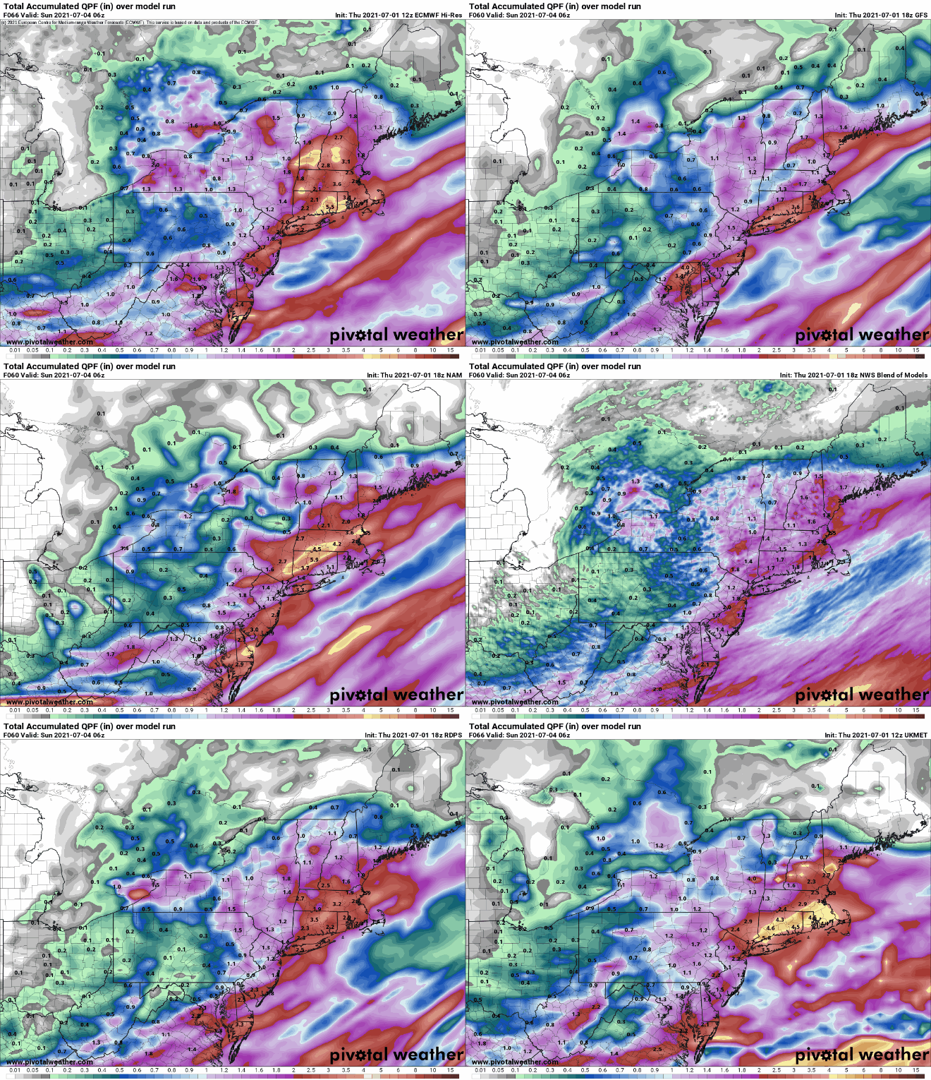
Parts of the region could see quite a bit of rain this weekend. Images provided by Pivotal Weather,

Over the weekend, the front washes out, but an upper-level low pressure system will slowly move across the region. This will keep clouds and cool temperatures in place, especially on Saturday, with some occasional showers, but neither day looks to be a washout. While Sunday isn’t ideal barbecue weather for the Fourth of July, it may not be THAT bad. Just keep an eye on the radar if you do have outdoor plans. By Monday, the upper low moves out, and we get back into sunshine and temperatures closer to normal for early July.
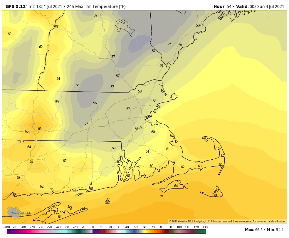
Some models try to keep it very cool around here on Saturday. Image provided by WeatherBell.

In the tropics, Tropical Storm Elsa was centered about 345 miles east-southeast of Barbados this evening, moving toward the west-northwest at 28 mph. Maximum sustained winds are near 45 mph. Tropical Storm Watches and Warnings are in effect for various islands in the eastern and northern Caribbean. The current forecast calls for some strengthening, as conditions remain favorable for the next day or so, but unless it slows down, it won’t strengthen too much. We’ll take a much more in-depth look at Elsa in a special blog post either Friday afternoon or evening.
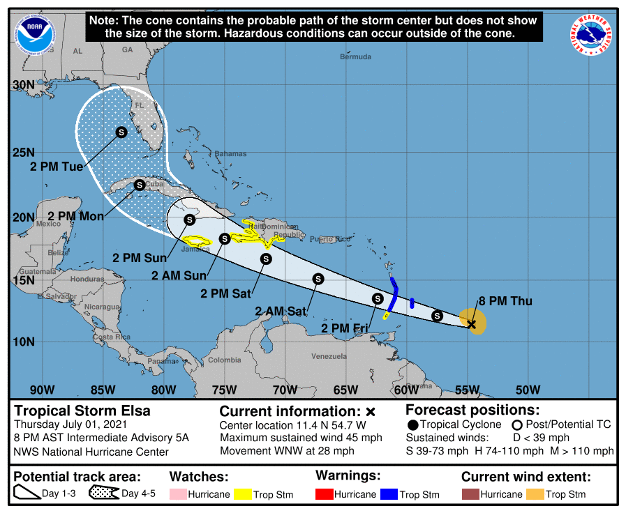
Forecast track for Tropical Storm Elsa. Image provided by the National Hurricane Center.

Thursday night: Cloudy with periods of rain and showers and some embedded thunderstorms. Low 59-66, a little milder near the South Coast.

Friday: Mostly cloudy with more showers, especially in the morning. High 64-71. Offshore: Winds becoming northeast to north 10-15 knots, gusts to 20 knots, seas 3-6 feet, visibility under 1 mile in showers and fog.

Friday night: Plenty of clouds with more showers likely. Low 53-60.

Saturday: Mostly cloudy and cool with occasional showers. High 59-66. Offshore: Northeast 10-20 knots gusts to 25 knots, seas 3-6 feet, visibility 1-3 miles in showers and fog.

Saturday night: Mostly cloudy, chance for a few showers. Low 51-58.

Fourth of July: Clouds and some sunny breaks with more showers possible. High 65-72. Offshore: Northwest 10-15 knots, seas 3-6 feet, visibility 1-3 miles in showers and fog.

Sunday night: Showers end in the evening, some clearing late at night. Low 52-59.

Monday: Partly to mostly sunny. High 74-81. Offshore: Southwest 10-20 knots, seas 3-5 feet, visibility 10 miles or better.

Weekend Outlook: June 25-28, 2021

The first full weekend of summer will feature a return of humidity and heat to the region.

A warm front will cross the region late tonight and early Friday. A few showers may accompany the front, maybe even a rumble of thunder, but they should be gone before midday, and they shouldn’t be that heavy either. Skies will start to clear out in the afternoon, and you’ll start to notice the increase in humidity. With the cloud cover likely hanging on through early afternoon, temperatures may not get that warm, especially along the Maine and New Hampshire Seacoast, where the front will take the longest to move through.

Dewpoints will jump into the middle to upper 60s on Saturday behind the warm front. Image provided by WeatherBell.

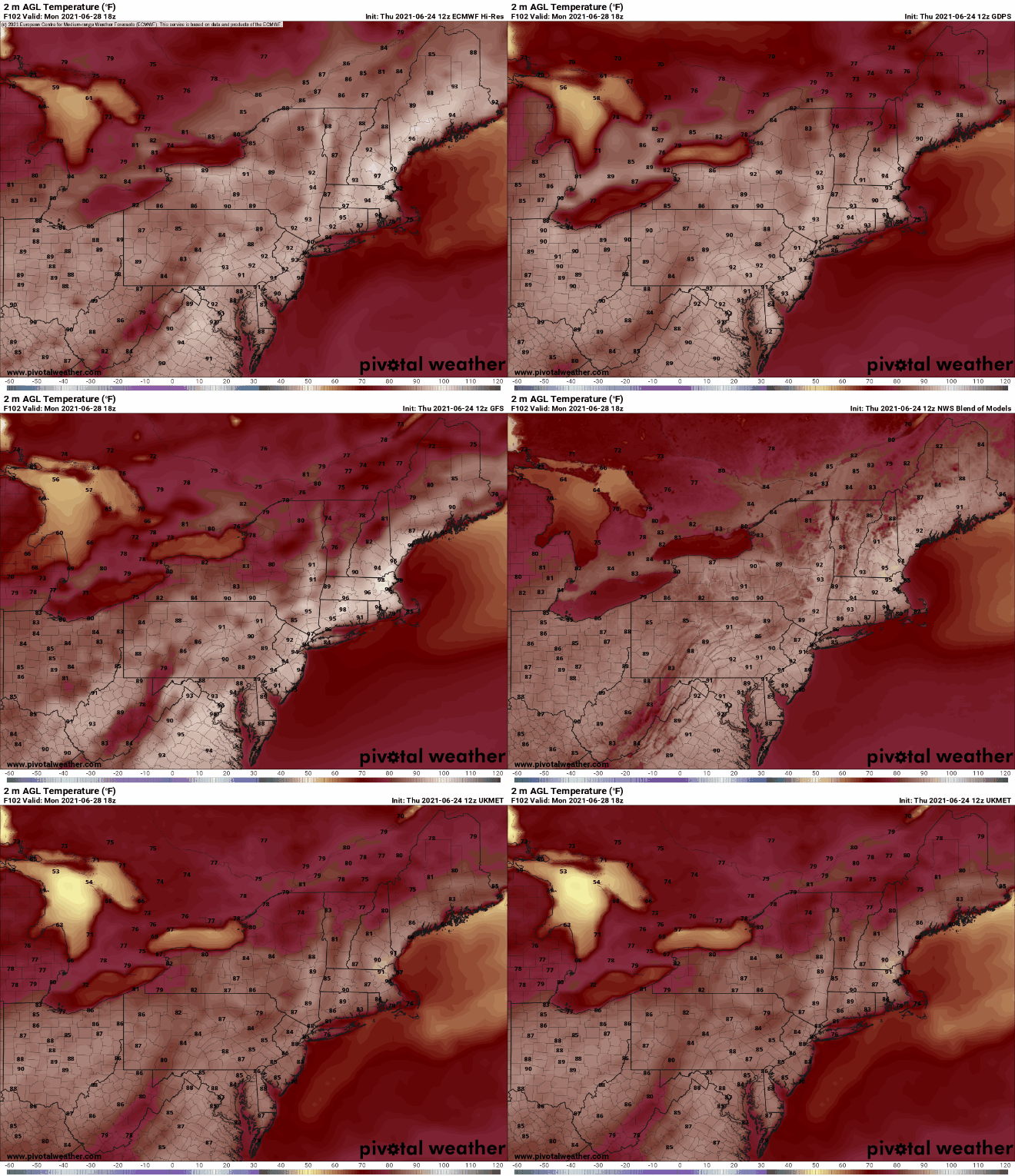
The rest of the weekend and Monday will feature typical summertime weather, with sunshine and afternoon clouds, along with a few pop-up showers and thunderstorms. We’ll have a frontal boundary well to our north and west, so we shouldn’t expect any organized severe weather with the front too far away, but any storms that do form could produce some localized downpours and gusty winds. In terms of temperatures, Sunday and Monday look quite toasty, and some models have temperatures getting well into the 90s away from the South Coast. The heat and humidity look to persist into at least the middle of next week.

Monday is looking like it’s going to be hot. Images provided by Pivotal Weather.

Thursday night: Increasing clouds with some showers possible late at night. Low 51-58, but temperatures may start to rise a bit after midnight, especially south of Boston

Friday: Any showers ending in the morning, some partial sunshine develops in the afternoon. High 72-79. Offshore: Southeast to south winds 10-15 knots, seas 2-4 feet.

Friday night: Partly to mostly cloudy. Low 59-66.

Saturday: Partly sunny, slight chance for a shower or thunderstorm. High 80-87. Offshore: South to southwest winds 10-15 knots, seas 2-4 feet.

Saturday night: Partly to mostly cloudy. Low 66-73.

Sunday: A mix of sun and clouds, slight chance for a shower or thunderstorm. High 85-92, cooler along the South Coast. Offshore: Southwest winds 10-20 knots, seas 3-5 feet.

Sunday night: Partly cloudy. Low 67-74.

Monday: Partly sunny, a late-day shower or thunderstorm is possible. High 89-96, cooler along the South Coast. Offshore: Southwest winds 10-20 knots, seas 3-5 feet.

Finally, we’re just going to touch on a couple of other topics. As you may have heard, some incredible heat is expected in the Pacific Northwest this weekend and early next week. Places like Portland, Seattle, and Spokane could shatter all-time records, with temperatures possibly topping 110 degrees. Meanwhile, in the tropics, a rather robust wave has moved off the coast of Africa, and some of the models show the potential for this wave to develop as it crosses the Atlantic. It’s a little early in the season for easterly waves, but we’ll keep an eye on its progress. We plan to write a special blog post on Friday that will cover both of these topics in greater detail.

Weekend Outlook: June 18-21, 2021

Summer officially starts Sunday night, but the last weekend of Spring is looking pretty good for the most part.

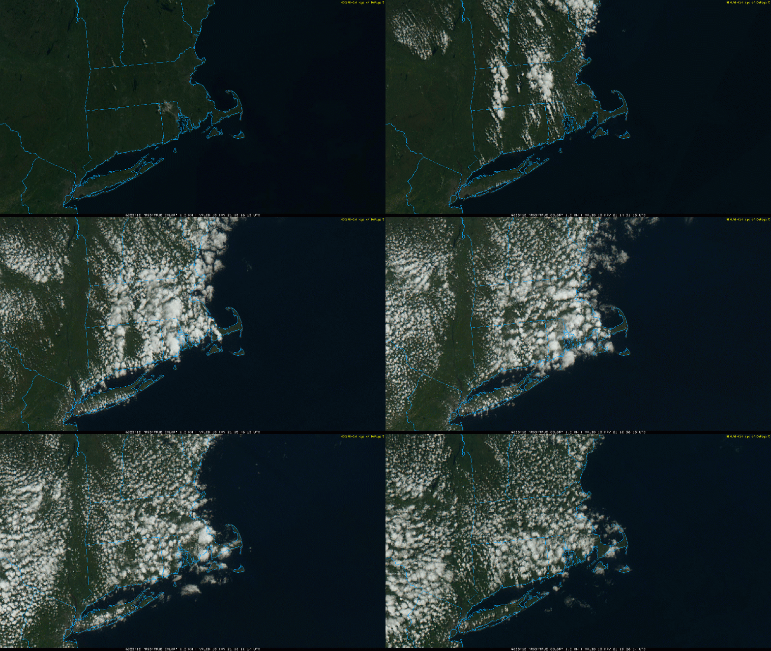
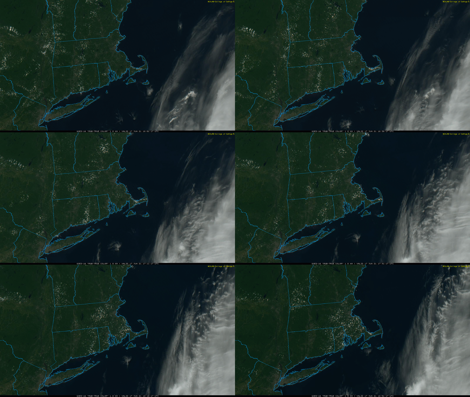
Aside from some pop-up cumulus, it’s a picture-perfect day across the region. Loop provided by the College of DuPage.

High pressure remains in control into Friday with more sunshine and warm temperatures as the high slides offshore. Humidity levels may start to creep up a bit on Friday, but it will still be comfortable. Low pressure will be heading into southern Canada later on Friday, and it will send a warm front our way at night. As that front moves through early Saturday morning, it may produce a few showers or thunderstorms. Not a big deal, and they should be done before most of you have finished your breakfast (or even gotten out of bed). Some sunshine may break out in the afternoon, and it will be quite warm and humid. A cold front will sweep across the region during the afternoon and evening. That front will produce another round of showers and thunderstorms. Depending on the timing of the front, some of those storms could become strong to possibly even severe. Don’t go cancelling any late-afternoon or evening plans, but if you’ll be outside, keep an eye to the sky.

High pressure builds back in on Sunday for the final day of Spring (the Summer Solstice occurs at 11:31pm Sunday night) with lower humidity, but it will remain quite warm. Humidity levels and temperatures will creep back up on Monday ahead of the next frontal system. Any shower or thunderstorm activity with this system should hold off until after dark.

We’ll give a quick mention about the tropics here as well. There are no active systems at this time, but there is a cluster of thunderstorms in the western Gulf of Mexico that is being monitored. It will likely become a tropical depression, possibly as early as tonight, then head northward. It should bring some heavy rain to parts of the Gulf Coast and Deep South this weekend. The National Hurricane Center is going to start issuing advisories on “Potential Tropical Cyclone Three” at 5pm EDT. We’ll likely write a blog post about the system either late tonight or tomorrow, once it actually becomes a tropical depression or tropical storm. Beyond that, some of the moisture from this system could interact with the cold front approaching us Monday night, but it’s still a little early to determine if that will happen or not. We’ll have a better idea by the time we issue our Weekly Outlook early Monday morning.

Satellite loop of the Gulf of Mexico where a tropical depression will likely develop tonight or tomorrow. Loop provided by NOAA.

Thursday night: Clear skies. Low 48-55.

Friday: Morning sunshine starts to fade behind increasing late-day clouds. High 77-84. Offshore: Southwest to south winds 10-15 knots, seas 2-4 feet.

Friday night: Mostly cloudy, chance for a few showers or thunderstorms late at night. Low 59-66.

Saturday: A few early showers, then becoming partly sunny. Another round of showers and thunderstorms is possible late in the day. High 80-87. Offshore: Southwest to south winds 10-20 knots, seas 3-6 feet.

Saturday night: Showers and storms end in the evening followed by clearing. Low 58-65.

Sunday: Sunshine and some afternoon clouds. High 81-88. Offshore: Southwest to south winds 10-15 knots, seas 2-4 feet.

Sunday night: Clear during the evening, clouds start to filter in late at night. Low 59-66.

Monday: Partly sunny. High 85-92, cooler along the South Coast. Offshore: South winds 10-15 knots, seas 2-4 feet.

Weekend Outlook: June 11-14, 2021

The heat and humidity are gone, and won’t be back for a while, but that doesn’t mean the weather will be perfect this weekend.

The first 9 days of June have averaged 4-8 degrees above normal across the region. Image provided by the Northeast Regional Climate Center.

High pressure settles in for Friday with dry and cool conditions. A weak frontal system will drop southward Friday night, possibly producing a few showers across the region late Friday night or early Saturday morning. High pressure builds back in for Saturday afternoon and evening with sunshine returning. It will remain cool, with easterly winds keeping locations right along the coast in the 60s. We’ll start to warm up again on Sunday, but another system approaches the region with some showers and possibly thunderstorms later Sunday and Sunday night. As that system slows down, another round of showers and thunderstorms is possible on Monday.

Thursday night: Clear to partly cloudy. Low 47-54.

Friday: Becoming partly to mostly cloudy. High 67-74. Offshore: Northwest winds 10-15 knots, seas 2-3 feet, unlimited visibility.

Friday night: Mostly cloudy, chance for a few showers, mainly in southern New Hampshire and northern Massachusetts. Low 51-58.

Saturday: Showers end early, then becoming partly sunny. High 69-76. Offshore: Northeast winds 10-15 knots becoming southeast 5-10 knots, seas 2-4 feet, visibility 1-3 miles early, improving in the afternoon.

Saturday night: Plenty of clouds. Low 52-59.

Sunday: A mix of sun and clouds, chance for some late-day showers. High 75-82. Offshore: Southwest to south winds 10-15 knots, seas 2-4 feet. Visibility lowering to 1-3 miles in late-day showers.

Sunday night: Mostly cloudy with scattered showers and thunderstorms. Low 55-62.

Monday: Intervals of clouds and sun, showers and thunderstorms possible, especially late in the day. High 71-78. Offshore: South winds 10-15 knots, seas 3-5 feet. Sunday: A mix of sun and clouds, chance for some late-day showers. Offshore: Southwest to south winds 10-15 knots, seas 2-4 feet. Visibility lowering to 1-3 miles in late-day showers.

Weekend Outlook: June 4-7, 2021

The first weekend of meteorological summer is upon us, and it’ll certainly feel like summer around here.

A warm front will move across the region this afternoon, and as an upper-level disturbance swings through tonight, those two will combine to bring in some showers and thunderstorms. While a few of them may produce some heavy rain near the South Coast, most of us shouldn’t see that much rain tonight. Another upper-level disturbance crosses the region on Friday accompanying a dying cold front. This will produce another round of showers and thunderstorms, mainly during the afternoon and evening. A few of these storms could produce downpours and gusty winds.

Last weekend’s rain erased the developing drought for much of southern New England. Image provided by the National Drought Mitigation Center.

Once everything moves offshore Friday night, high pressure builds back in for the weekend and Monday. We’ll dry out on Saturday and with developing sunshine, temperatures should get well into the 80s away from the South Coast. For Sunday and Monday (and into the middle of next week), we’ll have a Bermuda High in place, which means southwest winds pumping very warm to hot and humid air into the region. Temperatures will be near or just above 90 for most of us on Sunday, and on Monday, highs will reach the lower to middle 90s, perhaps even some upper 90s, which will be close to the record highs for much of the region. While it won’t be as humid as it normally is deeper into the summer, it’ll be fairly humid by early-June standards, with dewpoints in the 60s, meaning that it will feel like mid to upper 90s during the afternoon.

Monday is looking rather toasty. Image provided by Weathermodels.com

Thursday night: Cloudy with a few showers or a rumble of thunder, mainly along the South Coast. Low 59-66.

Friday: Plenty of clouds with some showers and thunderstorms possible, mainly during the afternoon. High 74-81, a little cooler along the South Coast. Offshore: Southwest winds 15-20 knots, gusts to 30 knots, seas 3-6 feet, visibility 1-3 miles in showers and fog UV Index: Moderate. Water temperatures are in the upper 50s to near 60.

Friday night: Showers and storms taper off during the evening, some clearing possible late at night. Low 56-63.

Saturday: Becoming partly to mostly sunny. High 83-90, cooler along the South Coast. Offshore: Southwest winds 15-25 knots, gusts to 30 knots, seas 3-5 feet, visibility 1-3 miles in morning fog. UV Index: High.

Saturday night: Partly cloudy. Low 64-71.

Sunday: Sunshine and a few clouds, becoming humid. High 88-95, cooler along the South Coast. Offshore: Southwest winds 10-15 knots, gusts to 25 knots, seas 2-4 feet, visibility 10 miles or better. UV Index: Very High.
Sunday night: Clear skies. Low 64-71.

Monday: Partly to mostly sunny. High 90-97, cooler along the South Coast. Offshore: West to southwest winds 10-15 knots, gusts to 25 knots, seas 2-4 feet, visibility 10 miles or better. UV Index: Very High.

Memorial Day Weekend Outlook: May 28-31, 2021

Earlier this week we had said that we were being optimistic that the weekend would turn out mostly dry. Yeah, turns out that probably isn’t going to work out.

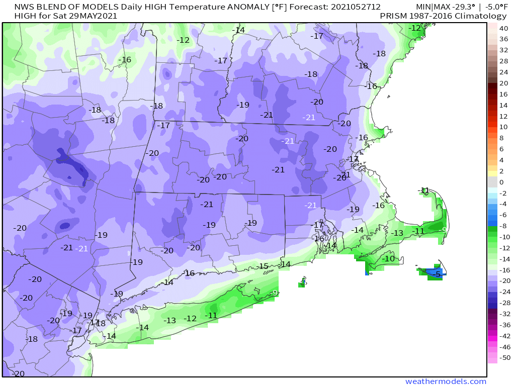
While high pressure is providing us with a terrific day today, it’s not going to last. Low pressure will move out of the Ohio Valley and ride along a stalled out frontal boundary to our south. That will spread clouds in late tonight, with a cloudy and rather cool day expected on Friday. Rain will develop Friday afternoon, and become heavy Friday night, especially south of the Massachusetts Turnpike. Rain will continue off and on Saturday, finally tapering off later in the day. With plenty of clouds and rain, temperatures on Saturday will be quite chilly for late May, with most places staying in the 50s.

Temperatures will be about 20 degrees below normal on Saturday. Image provided by Weathermodels.com

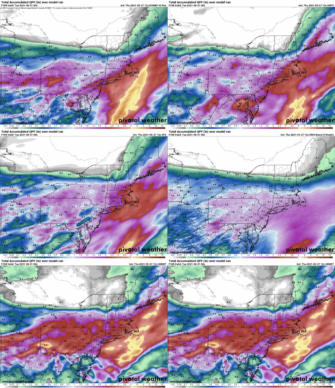
Clouds remain in place Saturday night, then another system moves in later Sunday into at least midday Monday. The first half of Sunday may not be that bad north of the Mass Pike, though still on the chilly side, and Memorial Day afternoon may not be a complete washout. But overall, on a scale of 1 to 10, we’d rate the Memorial Day weekend a 3 at this point. If there’s a bright side to this, after a fairly long dry spell, we’re going to get quite a bit of rain over the next few days, which will not only be good for your lawn and garden, but will wash most of the pollen out of the air (and off your cars). Many of the models may be overdoing the precipitation totals, but a solid 1-2 inches wouldn’t surprise us, especially south of the Mass Pike.

A solid 1-2 inches of rain (or more) is expected this weekend. Images provided by Pivotal Weather.

(Editor’s note: Per a request, we’re going to add a beach and boating forecast to the daytime portions of the Weekend Outlook through Labor Day Weekend)

Thursday night: Partly cloudy. Low 46-53.

Friday: Becoming mostly cloudy with showers developing in the afternoon. High 60-67. Offshore: East winds 10-15 knots, gusts to 20 knots, becoming southeast late in the day, especially for the North Shore. Seas 2-4 feet, visibility lower to 1-3 miles in late-day showers. Water temperatures range from the low 50s off the North Shore to the upper 50s south of the Cape and Islands.

Friday night: Showers becoming a steady rain overnight, breezy. Low 40-47.

Saturday: Showers taper off and end by early afternoon, windy, and chilly. High 48-55. Offshore: Northeast winds 15-25 knots, gusts to 40 knots, especially near Cape Cod. Seas 4-7 feet, visibility under 1 mile in rain.

Saturday night: Mostly cloudy, showers may redevelop along the South Coast toward daybreak. Low 42-49.

Sunday: A few breaks of sun across southern New Hampshire early, otherwise cloudy with showers spreading across the region from south to north. High 51-58. Offshore: Northeast winds 15-20 knots, gusts to 30 knots. Seas 4-8 feet, visibility 1-3 miles in showers.

Sunday night: Periods of rain and showers. Low 43-50.

Memorial Day: Cloudy with rain tapering off and ending by early afternoon. High 57-64. Offshore: North to northeast winds 10-15 knots, diminishing in the afternoon. Seas 3-6 feet, visibility 1-3 miles in showers.

Weekend Outlook: May 21-24, 2021

Our early taste of summer continues through the weekend, but changes are on the way.

High pressure remains in control on Friday with partial sunshine and warm temperatures. We’ll only have partial sunshine as some smoke from wildfires in Canada will drift across the region at times, thanks to our northwesterly flow aloft. A series of weak disturbances will move along that flow over the next couple of days, bringing us some additional clouds and possibly a few showers and thunderstorms, especially late in the day Saturday. Not everyone will get one, so don’t go cancelling any outdoor plans, but keep an eye on the sky (or the radar) if you will be outside.

Sunday could be a very warm day across the region. Image provided by Weathermodels.com

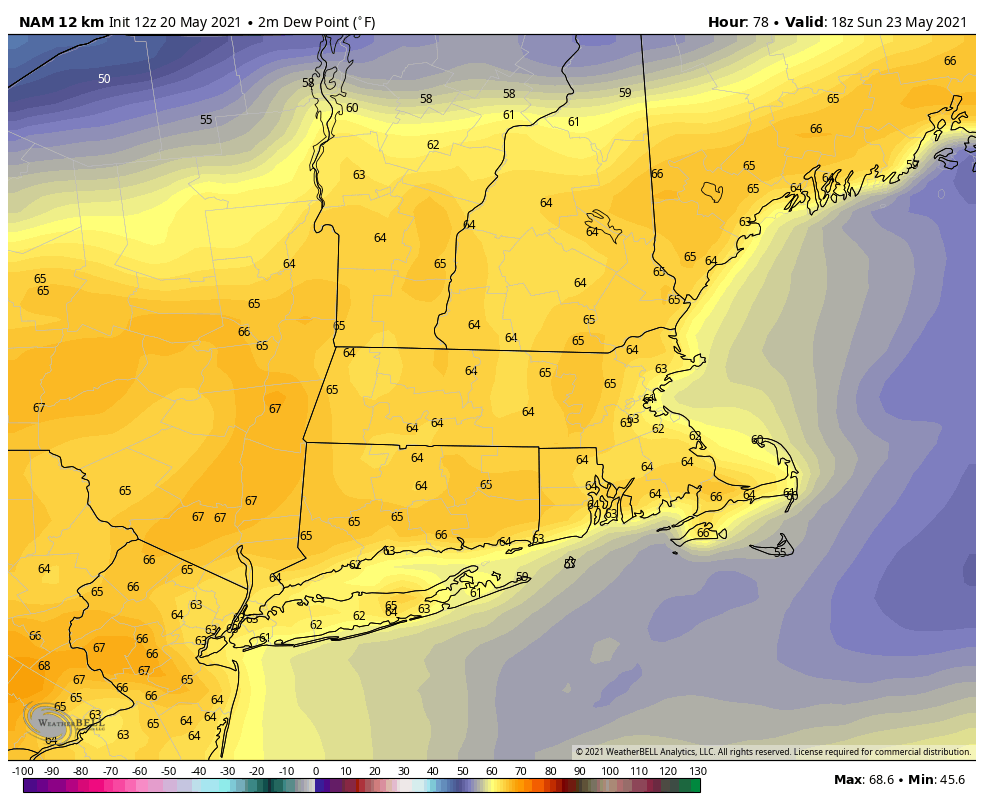
Sunday looks like it’ll be a warm and somewhat humid day (by May standards), but a backdoor cold front will be approaching the region. These fronts usually don’t produce a lot of precipitation, but with the airmass we’ll have in place and another disturbance dropping down, we’ll likely see showers and thunderstorms develop. There will likely be more of them than on Saturday, but the day shouldn’t be a washout. A few of the storms that do form could produce gusty winds and heavy downpours, so again, if you’ve got outside plans, be aware of what’s going on. High pressure builds back in on Monday with much cooler conditions.

Dewpoints could get into the lower to middle 60s on Sunday. Image provided by WeatherBell.

Thursday night: Partly to mostly cloudy, slight chance for a shower, mainly well north of Boston. Low 47-54.

Friday: A mix of sun and clouds, just a slight chance for an afternoon shower, mainly well north and west of Boston. High 79-86, cooler along the coast.

Friday night: Mostly cloudy, a few showers are possible. Low 55-62.

Saturday: More clouds than sunshine, some showers and thunderstorms are possible during the afternoon. High 80-87, cooler along the coast, especially the South Coast and Cape Cod..

Saturday night: Partly cloudy. Low 58-65.

Sunday: Partly sunny, chance for some afternoon showers and thunderstorms. High 83-90.

Sunday night: Clear to partly cloudy. Low 47-54.

Monday: Partly to mostly sunny. High 65-72.

A low pressure area near Bermuda could become a subtropical storm in the next few days. Loop provided by NOAA.

Finally, it’s getting to that time of year – hurricane season. The season officially begins on June 1, and we’ll have a special post dedicated to the start of the season, including statistics about how here in New England we are significantly overdue for a storm. However, there is an area of low pressure northeast of Bermuda that the National Hurricane Center has its eyes on right now. It’s not tropical, but they think it could become subtropical in the next day or two as it heads southwestward toward Bermuda. We’re not sure if it will become subtropical or not, but then again, that’s not our call. They’ll likely waste the first name of the season (Ana) on the storm, which will make seven years in a row that we get a “named” storm before the official start of hurricane season. Over the weekend it will turn back toward the northeast and head out into the open Atlantic. If it does get named, we’ll have a special post on it. Also, NOAA issued their hurricane outlook today. To the surprise of nobody, NOAA is expecting another above normal hurricane season with 13-20 named storms, 6-10 hurricanes, and 3-5 major hurricanes.

Weekend Outlook: May 14-17, 2021

Typical springtime weather is expected right through the weekend. Some showers are possible each afternoon, but don’t go cancelling any outdoor plans.

Today’s satellite loop will look pretty similar to each of the next few days. Loop provided by the College of DuPage.

The weather pattern for the next several days will be fairly simple. At the surface, high pressure to the south will result in seasonably mild conditions through the weekend and into Monday. Temperatures have been on the cool side lately, so even though we’ll only be right around or a little above normal for the next few days, it will feel rather nice. While we’ve got high pressure at the surface, we’ll have a series of weak disturbances moving through aloft. So, each day will likely follow the same pattern – sunshine in the morning, clouds start to develop by late morning, and some widely scattered showers pop-up each afternoon. A few rumbles of thunder are even possible. Most of these showers will be light, and not everyone will see them. The best chance for them looks to be Sunday afternoon, but again, don’t wipe out any outdoor plans, as most of us will still enjoy a rather nice day.

Temperatures have been below normal across the Northeast thus far in May. Image provided by the Northeast Regional Climate Center.

Thursday night: Clear to partly cloudy. Low 43-50.

Friday: Sunshine gives way to afternoon clouds, slight chance for a late-day shower. High 68-75.

Friday night: Clear to partly cloudy. Low 44-51.

Saturday: A mix of sun and clouds, chance for an afternoon or evening shower. High 69-76.

Saturday night: Partly to mostly cloudy. Low 46-53.

Sunday: Partly sunny with a few showers possible during the afternoon. High 68-75.

Sunday night: Clear to partly cloudy. Low 45-52.

Monday: A mix of sun and clouds, chance for a few showers. High 67-74.

Weekend Outlook: May 7-10, 2021

We’ve needed the rain that we received this week, and there’s more on the way, but for the most part, we’ll have some nice weather for the weekend.

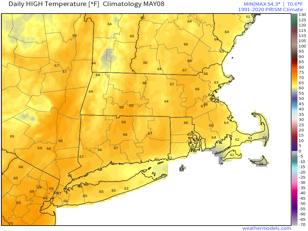
High pressure remains in control into Friday, with generally dry and mild conditions, though temperatures are still a little below normal for early May. Clouds start to stream in late Friday and Friday night as a coastal low passes south and east of the region and an upper-level disturbance approaches from the west. For the most part, the coastal low will miss us, though a few showers are possible across the Cape and Islands. The upper-level disturbance will bring in some showers on Saturday, but they won’t be that heavy or that widespread.

Average high temperatures for early May are generally in the middle 60s. Image provided by Weathermodels.com

High pressure builds back in on Sunday with dry and cool conditions, but another system will quickly follow. This will bring in some rain for Sunday night and Monday. Once it again, it shouldn’t be that heavy, but since rainfall is still well below normal for the year, every little bit helps. Some clearing may take place Monday afternoon, and if we can get enough sun, temperatures could end up even warmer than we are currently expecting.

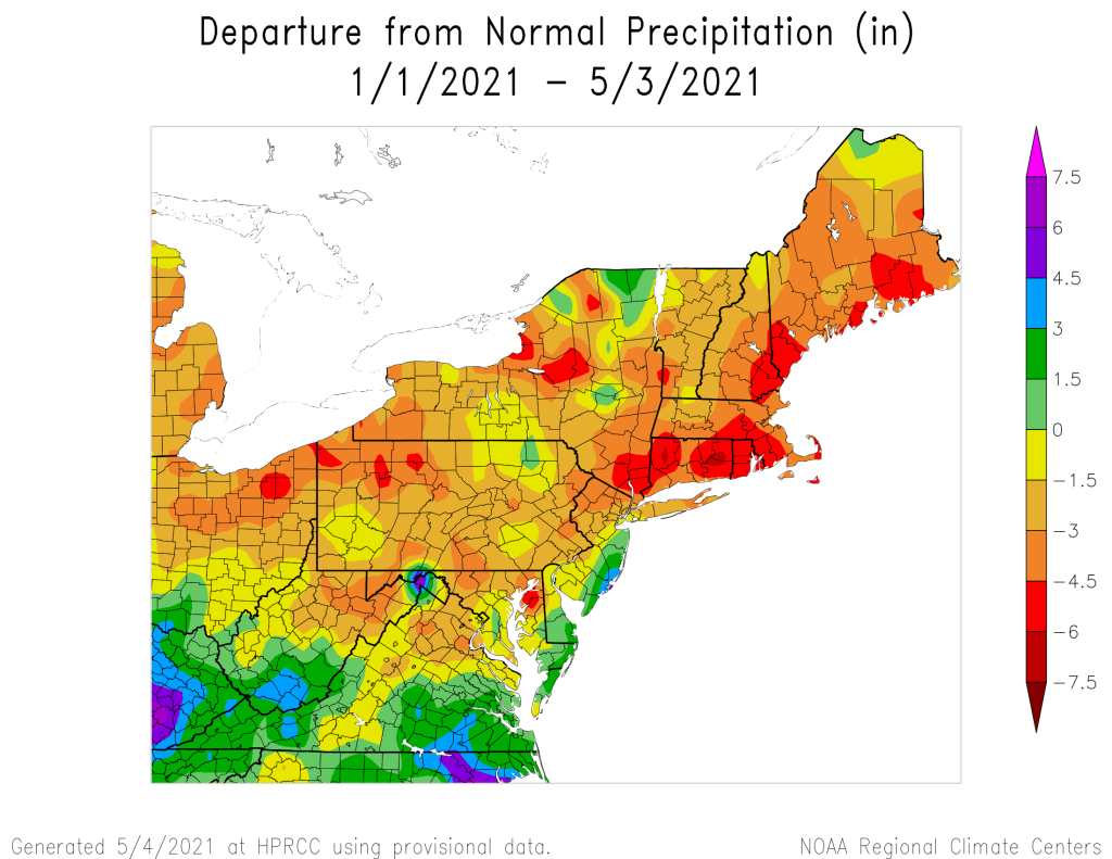
Despite this week’s rain, precipitation is running 3-6 inches below normal for the year-to-date across the region. Image provided by the Northeast Regional Climate Center.

Thursday night: Becoming partly to mostly cloudy. Low 37-44.

Friday: Partly sunny. High 56-63.

Friday night: Mostly cloudy. Low 36-43.

Saturday: Cloudy with a chance for a few showers. High 52-59.

Saturday night: Cloudy in the evening, then clearing after midnight. Low 39-46.

Sunday: Sunny in the morning, clouds return in the afternoon. High 59-66.

Sunday night: Cloudy with showers likely. Low 40-47.

Monday: Cloudy with showers during the morning, some sunny breaks may develop in the afternoon, breezy. High 56-63.

Weekend Outlook: April 30 – May 3, 2021

We’re stuck in a typical spring weather pattern for New England, which means that it’s not going to be sunny and warm for the most part, and probably won’t be for a while.

Temperatures are in the upper 40s and 50s north of a frontal boundary this afternoon, with 70s and 80s south of it. Image provided by Weathermodels.com

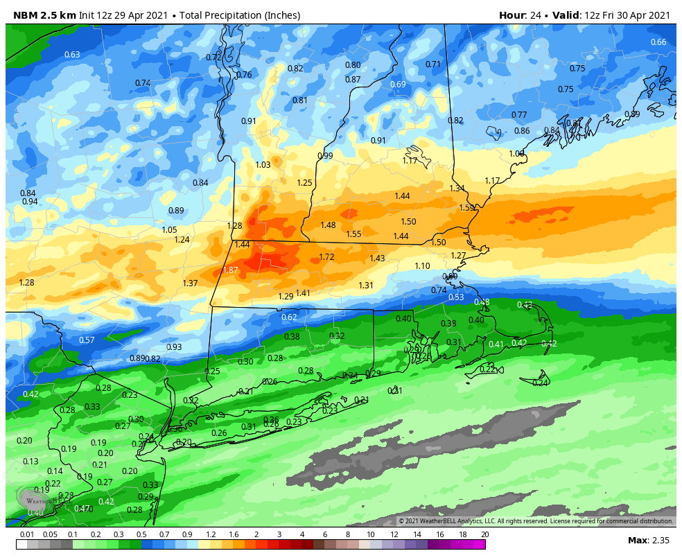
A wavy frontal boundary will be teasing us for the next several days while several waves of low pressure ride along it. South of that boundary, temperatures will be in the 70s and 80s, but north of it, only in the 50s and 60s. Unfortunately, that boundary is going to stay just to the south of our area for the most part. One wave rides along the front tonight, with periods of rain likely. The rain tapers off by Friday morning, and as the low pulls away. we may see some breaks of sunshine develop. As winds shift into the west and northwest behind the system, temperatures will actually warm up a bit, since the winds won’t be off the chilly Atlantic any longer. However, an upper-level low will be moving across the region, and it could help produce a few more showers Friday evening and night. With cooler air moving in, we could even see some wet snowflakes mix in, especially well inland and across some of the hills. High pressure will try to build in on Saturday with some sunshine along with gusty winds and cool temperatures.

Your lawn will appreciate the nice drink of water it will get over the next 18-24 hours. Image provided by WeatherBell.

On Sunday, that pesky front will try to lift back northward as a warm front. We’ll turn milder, but also have some clouds moving in with a few showers possible, mainly at night. The question becomes, how far northward does that warm front get on Monday? South of the front, temperatures will be well into the 60s and 70s, while north of it, temperatures will only be in the 50s, perhaps upper 40s. Right now, we’re leaning toward the colder side, because that is more typical of early May, but the warm air may settle in south of the Mass Pike. Some showers are also likely during the day, as low pressure slowly approaches from the west.

The models have differing opinions on how far northward the warm air gets on Monday. Images provided by Pivotal Weather.

Thursday night: Cloudy with periods of rain and showers likely. Low 44-51.

Friday: Showers end early, some sunny breaks may develop in the afternoon, becoming windy. High 61-68.

Friday night: Mostly cloudy and windy with scattered showers, possibly mixed with wet snow across the interior. Low 34-41.

Saturday: Becoming partly to mostly sunny, still breezy. High 56-63.

Saturday night: Clouds return. Low 39-46.

Sunday: More clouds than sunshine, breezy, and warmer. High 65-72.

Sunday night: Partly to mostly cloudy, chance for showers late at night. Low 44-51.

Monday: Cloudy with a chance of showers. High 58-65.