The first full weekend of summer will feature a return of humidity and heat to the region.
A warm front will cross the region late tonight and early Friday. A few showers may accompany the front, maybe even a rumble of thunder, but they should be gone before midday, and they shouldn’t be that heavy either. Skies will start to clear out in the afternoon, and you’ll start to notice the increase in humidity. With the cloud cover likely hanging on through early afternoon, temperatures may not get that warm, especially along the Maine and New Hampshire Seacoast, where the front will take the longest to move through.

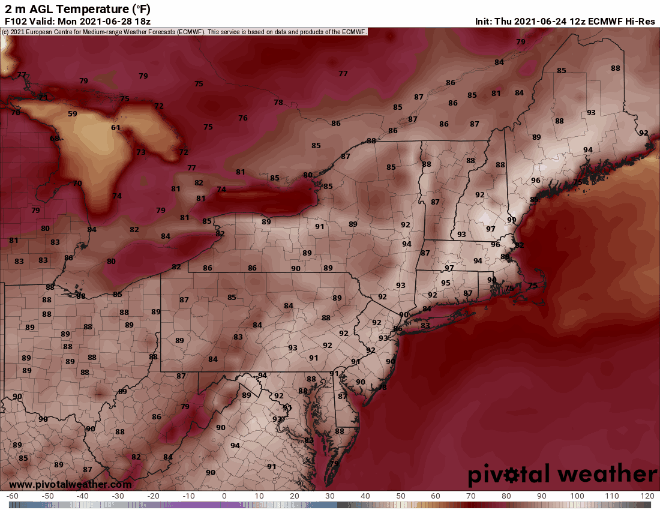
The rest of the weekend and Monday will feature typical summertime weather, with sunshine and afternoon clouds, along with a few pop-up showers and thunderstorms. We’ll have a frontal boundary well to our north and west, so we shouldn’t expect any organized severe weather with the front too far away, but any storms that do form could produce some localized downpours and gusty winds. In terms of temperatures, Sunday and Monday look quite toasty, and some models have temperatures getting well into the 90s away from the South Coast. The heat and humidity look to persist into at least the middle of next week.
Thursday night: Increasing clouds with some showers possible late at night. Low 51-58, but temperatures may start to rise a bit after midnight, especially south of Boston
Friday: Any showers ending in the morning, some partial sunshine develops in the afternoon. High 72-79. Offshore: Southeast to south winds 10-15 knots, seas 2-4 feet.
Friday night: Partly to mostly cloudy. Low 59-66.
Saturday: Partly sunny, slight chance for a shower or thunderstorm. High 80-87. Offshore: South to southwest winds 10-15 knots, seas 2-4 feet.
Saturday night: Partly to mostly cloudy. Low 66-73.
Sunday: A mix of sun and clouds, slight chance for a shower or thunderstorm. High 85-92, cooler along the South Coast. Offshore: Southwest winds 10-20 knots, seas 3-5 feet.
Sunday night: Partly cloudy. Low 67-74.
Monday: Partly sunny, a late-day shower or thunderstorm is possible. High 89-96, cooler along the South Coast. Offshore: Southwest winds 10-20 knots, seas 3-5 feet.
Finally, we’re just going to touch on a couple of other topics. As you may have heard, some incredible heat is expected in the Pacific Northwest this weekend and early next week. Places like Portland, Seattle, and Spokane could shatter all-time records, with temperatures possibly topping 110 degrees. Meanwhile, in the tropics, a rather robust wave has moved off the coast of Africa, and some of the models show the potential for this wave to develop as it crosses the Atlantic. It’s a little early in the season for easterly waves, but we’ll keep an eye on its progress. We plan to write a special blog post on Friday that will cover both of these topics in greater detail.
