We’ve actually got a fairly simple, but cold, forecast coming up for the next several days.
A cold front crossed the region earlier today, and that cold air will continue to rush in tonight, resulting in a very chilly night as skies clear out across parts of the area. High pressure builds in for Friday with sunshine and cold temperatures, except across Cape Cod where northerly winds blowing over the relatively mild ocean will result in some ocean-effect snow showers. Another chilly night is likely Friday night, but as winds turn more into the northeast, some of those ocean-effect snow showers could move into parts of Plymouth County. Saturday remains mostly sunny but not quite as chilly, though we will still have some ocean-effect snow showers across Cape Cod and parts of Plymouth County. Temperatures start to moderate a bit on Sunday (but will remain chilly), then another cold front moves through late Sunday, bringing colder air back in for Monday.
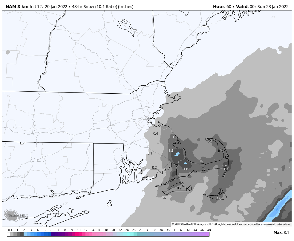
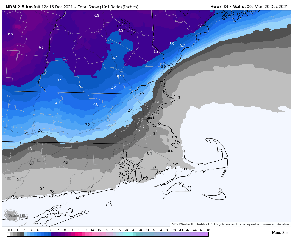
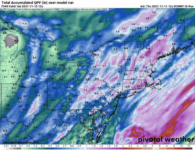
Ocean-effect snow could produce an inch or two across parts of southeastern Massachusetts and Cape Cod. Image provided by WeatherBell.
Thursday night: Gradual clearing, mainly north and west of Boston. Low 0-7 north and west of Boston, 8-15 south of Boston, milder across Cape Cod.
Friday: Becoming partly to mostly sunny, except cloudy with some snow showers across Cape Cod and the Islands. High 17-24.
Friday night: Cloudy with some snow showers across southeastern Massachusetts and Cape Cod, clear to partly cloudy elsewhere. Low -2 to +5 north and west of Boston, 6-13 south of Boston, milder across Cape Cod.
Saturday: Mostly cloudy with some snow showers across southeastern Massachusetts and Cape Cod, partly to mostly sunny elsewhere. High 21-28.
We’ve got a lot going on over the next few days across the region, and you probably won’t like most of it.
A storm system will develop off the Mid-Atlantic coast tonight, and rapidly strengthen as it heads northeastward, passing well south and east of the region on Friday. However, it will be close enough to spread some rain and strong winds into Cape Cod and possibly southeastern Massachusetts. At the same time, a cold front will drop down from the northwest, ushering arctic air back into the region. This may allow the rain to change to snow before it ends. Temperatures will quickly drop Friday afternoon and evening as gusty northwest to north winds continue to send the arctic air in. Any surfaces that are wet from the rain across southeastern Massachusetts will quickly freeze up Friday afternoon and evening, so keep this in mind if you’re heading out that evening.
Northerly winds may gusts to 35-45 mph on Friday, ushering arctic air into the region. Image provided by WeatherBell.
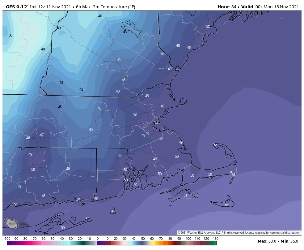
We’ll drop into the single numbers by Saturday morning, with some subzero lows north and west of Boston. With strong winds, wind chills will be well below zero Friday night and Saturday morning, so dress appropriately if you’ll be outside. Saturday looks to be a day similar to this past Tuesday with sunshine and some afternoon clouds, possibly a few snow showers across Cape Cod, and temperatures struggling to reach the lower to middle teens. Winds die down Saturday night, resulting in another chilly night, with subzero lows possible once again. Sunday starts off with some sunshine, but clouds start to move in during the afternoon as temperatures start to moderate. This brings us to the complicated part of the forecast.
With wind chills like this, Saturday morning will be a good time to stay inside. Image provided by WeatherBell.
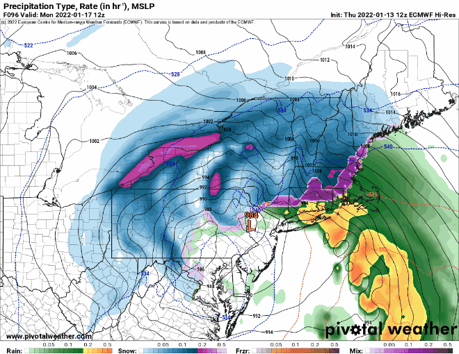
Another strong low pressure system will develop across the Southeast and make its way up the East Coast on Sunday. There is still some uncertainty with the exact track that the storm will take, but for now it looks like it may stay near the coast or just inland, passing directly over, or just west, of our area on Monday, though this is subject to change. This track would result in snow changing to sleet and/or freezing rain and then plain rain across much of the area. However, this is far from a guarantee. There are still some models that bring the storm a little farther south and east, which would result in more snow and less rain, but as we’ve mentioned numerous times, the models have been less than trustworthy beyond 2 or 3 days recently. When (or if) a change to mix and/or rain occurs will also have a significant impact on how much snow accumulates. Given the amount of uncertainty, it’s still WAY too early to try and pin down any potential accumulations, but it’s safe to say that the farther north and west of Boston you are, the better the chance you’ll need to fire up the snowblower or find your shovels. We’ll try to post an update this weekend, once we have some better clarity on the storm.
There is plenty of uncertainty in regards to storm for Sunday/Monday. Images provided by Pivotal Weather.
Thursday night: Partly to mostly cloudy, rain may develop across Cape Cod towards daybreak. Low 26-33.
Friday: Mostly cloudy, rain likely across Cape Cod and southeastern Massachusetts, possibly changing to snow before ending, becoming windy. High 35-42, but temperatures will start to quickly drop in the afternoon.
Friday night: Clearing, windy, and much colder, except partly cloudy with a few snow showers across Cape Cod. Low -3 to +4, except milder across Cape Cod and the Islands.
Saturday: Partly to mostly sunny, breezy, and very cold, except partly sunny with a few snow showers across Cape Cod. High 10-17.
Saturday night: Clear skies with diminishing winds. Low -2 to +5, except milder across Cape Cod and the Islands.
Sunday: Sunshine to start the day, clouds move in during the afternoon. High 23-30.
Sunday night: Cloudy and becoming breezy with snow developing, possibly rain across Cape Cod. Low 14-21.
Monday: Snow, possibly changing to sleet/freezing rain/rain, especially the farther south and east you go. High 39-46.
Our first snowstorm of the season is on the way for Friday, but it’s just part of a colder pattern we’re heading into for the weekend and beyond.
A variety of advisories, watches, and warnings are in effect across the region. Image provided by the National Weather Service office in Norton, MA.
Low pressure is moving across the Tennessee Valley this afternoon, and it will head east-northeastward, moving off the Mid-Atlantic coast tonight, passing south and east of New England on Friday as it intensifies. We’ll see snow developing before daybreak, and it may fall heavy at times during the morning, which will result in significant problems for the morning commute. The snow should come to an end by mid-afternoon across the region. Based on the trends in the models since last night, we are adjusting our snowfall forecast upwards a bit, but not that much. Here’s our latest projections:
The National Blend of Models is closest to our thinking right now, but it may be a bit on the high side. Image provided by WeatherBell.
The storm pulls away Friday evening, and skies clear out as high pressure builds in, setting up a sunny but rather chilly Saturday, with many places likely staying in the 20s all day. With clear skies and fresh snowcover, temperatures will quickly plunge Saturday evening into the teens and possibly single numbers in some spots. Clouds stream back in late Saturday night as another system moves toward the region. While this system looks a bit milder, with southerly winds warming things up a bit on Sunday, the models have been trending less mild with every run. With that in mind, we’ll probably see some snow showers or a little freezing rain develop north and west of Boston Sunday afternoon, changing to rain by evening. Keep this in mind if you are going to be out and about Sunday afternoon. Elsewhere, just plain rain is expected. The rain may mix with some wet snow before winding down around daybreak Monday. After that, some of the coldest air thus far this winter will pour into the region. Temperatures may not rise much, if at all, Monday afternoon. The coldest weather looks to arrive on Tuesday, when highs may stay in the teens, with subzero lows possible Tuesday night. We’ll have more info on that in our Weekly Outlook early Monday morning.
Tuesday looks like a very cold day across the region. Image provided by Weathermodels.com
Could we actually have a White Christmas across the area? It’s certainly a possibility.
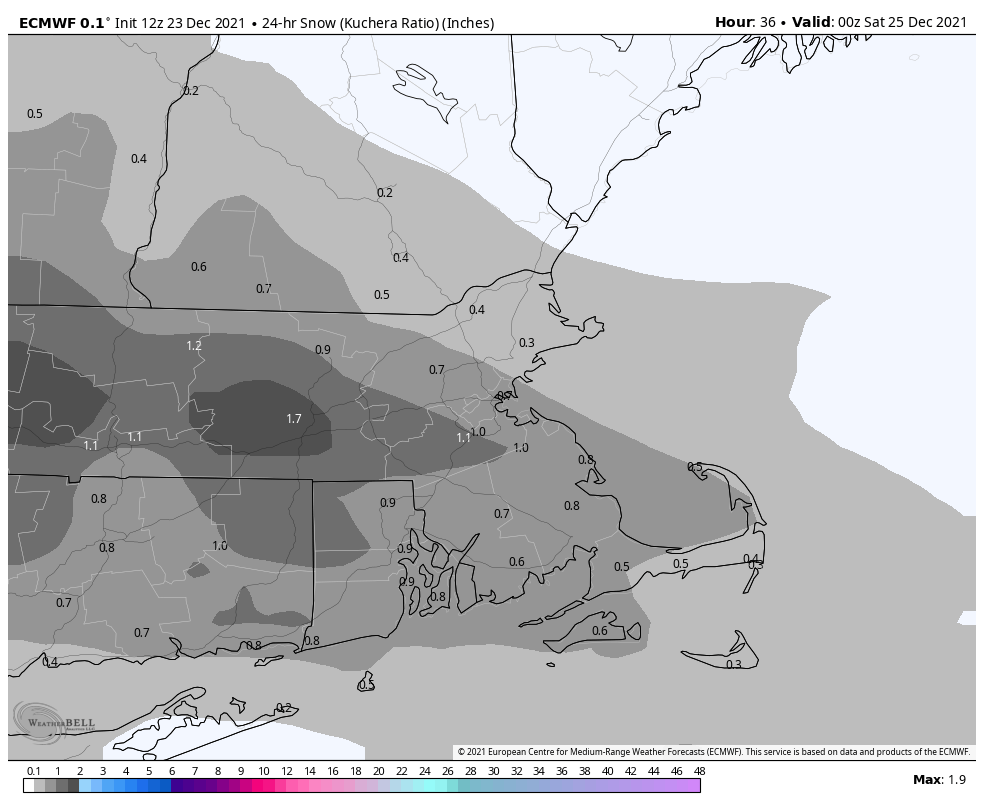
Clouds will thicken up tonight as a weak storm system moves toward the region. That system will spread some light snow across the area Friday morning. It won’t be a big deal, with most places receiving a coating to an inch or two of snow. If you do have to work Friday morning, the commute could be a little slippery. We’ll have some clearing in the afternoon, but temperatures will stay chilly, so much of the snow will remain on the ground. The “official” definition of a White Christmas is 1″ or more of snow on the ground at 7am. Will that happen? It could in some spots, but even if there’s not 1″, the grass should still be white for many of us.
We’re not expecting much snow Friday morning. Image provided by WeatherBell.
Another system quickly approaches for Christmas Day into Sunday morning. This one looks a bit milder, with some rain likely during the afternoon, possibly starting as some freezing rain or sleet from the Merrimack Valley into southern New Hampshire. The rain won’t be that heavy, but as the system passes by Saturday night, colder air will fill in behind it, with a chance to light snow possible, again, mainly in southern New Hampshire and possibly the Merrimack Valley. Some minor accumulations are possible, but again, nothing major is likely. We’ll clear out again for Sunday afternoon into Monday as high pressure builds back in.
Christmas Eve: Light snow ends early, some afternoon sunny breaks. Snow accumulation a coating to perhaps 2 inches in spots. High 30-37.
Friday night: Mostly cloudy. Low 20-27.
Christmas Day: Cloudy with showers developing, possibly starting as some freezing drizzle or sleet from the Merrimack Valley into southern New Hampshire. High 36-43.
Saturday night: Showers may change back to wet snow, mainly across southern New Hampshire and the Merrimack Valley. Low 27-34.
Sunday: Rain or snow showers end early, some sunny breaks in the afternoon. High 37-44.
This shouldn’t be a surprise, since it’s mid-December, but it’s going to snow this weekend.
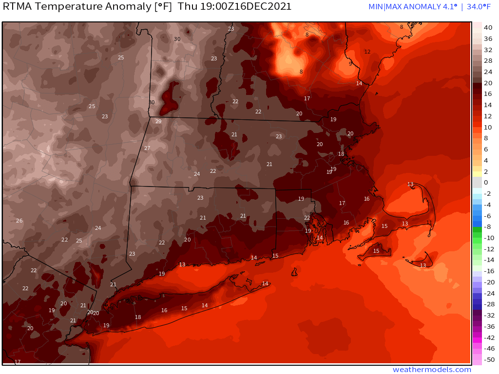
Temperatures are 15-25 degrees above normal this afternoon. Image provided by Weathermodels.com
After a mild day, a cold front will approach the region tonight, but only a few stray showers will accompany it. The front moves through early on Friday, but we’ll remain mild before a stronger push of colder air moves in late in the day as high pressure starts to build in across southern Canada. As we get to Saturday, low pressure will begin moving out of the Midwest and head towards New England, while a secondary area of low pressure develops south of New England. Exactly where this low tracks will help us determine how far north the warmer air will push, which is a key part of the forecast.
Where does the low track and how far north does the warm air penetrate? The models don’t agree. Images provided by Pivotal Weather.
Snow should develop across the region towards midday or a little thereafter. A very quick change to rain is expected across the South Coast, if it doesn’t start as rain there. The rain/snow line should quickly move northward during the rest of the afternoon and evening. The evening and overnight is where things get tricky. The warmer air likely only gets as far north as the Mass Pike or possibly Route 2. However, we’ll also have warmer air moving in aloft, which means a change to sleet or freezing rain is possible across northern Massachusetts and possibly southern New Hampshire, even if it doesn’t all change to plain rain. Any changeover will have a significant impact on snow amounts. As the low moves away early Sunday, a change back to snow is possible before everything winds down toward daybreak. High pressure then builds in with sunshine and cooler conditions for Sunday afternoon and Monday.
So, how much are we looking at? There are plenty of models out there showing a decent snowstorm, especially across the interior. We’re not buying it. We think they’re underestimating the mild air aloft. A quicker change to sleet and/or rain than what some of the models are showing seems more likely, especially the farther south and east you go. So, having said that, here’s our thinking:
Cape Cod/South Coast: A few flakes Points south and east of Interstate-95: 1″ or less Metro West/North Shore: 1-2″ Merrimack Valley/NH Seacoast: 1-3″ Southern NH/Central MA: 3-5″ Central NH: 4-7″
The National Blend of Models is probably closest to our thinking for snowfall totals. Image provided by WeatherBell.
Thursday night: Mostly cloudy and breezy, slight chance for a shower, some clearing late. Low 44-51.
Friday: Becoming mostly sunny and breezy, high clouds start to stream back in late in the day. High 50-57.
Friday night: Increasing and thickening clouds. Low 28-35.
Saturday: Cloudy with snow developing during the afternoon, quickly changing to rain along the South Coast. High 35-42.
Saturday night: Light snow across southern New Hampshire, changing to sleet and freezing rain across northern Massachusetts, and plain rain elsewhere. Low 27-34.
Sunday: Rain or snow showers ending around daybreak, clearing in the afternoon. High 34-41.
Sunday night: Clear and colder. Low 12-19.
Monday: Sunshine and some afternoon clouds. High 27-34.
The next few days will not feel like mid-December, but the pattern won’t exactly be quiet.
Normal high temperatures for this time of year are in the upper 30s to lower 40s. Image provided by Weathermodels.com
We’ll have a cool evening with high pressure in control, but clouds will be streaming in ahead of a warm front. As that front moves through overnight, temperatures will start to rise after midnight, and we could see a few flurries or sprinkles. Friday will be milder with plenty of clouds, but aside from a few stray sprinkles or showers, the day should remain dry. As low pressure heads into southern Canada, it will drag a strong cold front toward the region. Ahead of that front, we’ll have some showers developing Friday night, continuing off-and-on through Saturday. The day won’t be a washout, but it won’t be completely dry either. That’s not the big story for the day though. South to southwest winds will be quite gusty, sending even warmer air into the region. Many locations will likely top 60 degrees once again. The front moves through overnight, with showers ending by daybreak. Skies clear out for Sunday and Monday with high pressure building in, but temperatures will still be near to even above normal for mid-December.
Saturday looks very mild, especially during the afternoon and evening. Image provided by WeatherBell.
Thursday night: Mostly cloudy, chance for a flurry or a sprinkle. Low 23-30 during the evening, temperatures may rise a bit after midnight.
Friday: Mostly cloudy, slight chance for a shower. High 42-49.
Friday night: Mostly cloudy, showers developing late at night. Low 29-36 during the evening, temperatures rise again overnight.
Saturday: Cloudy, windy, and mild with occasional showers. High 57-64.
Saturday night: Cloudy and windy with more showers, possibly a thunderstorm, ending late at night. Low 34-41.
Sunday: Becoming mostly sunny, still breezy in the morning. High 40-47.
Sunday night: Clear. Low 28-35.
Monday: Sunshine and a few clouds. breezy at times. High 46-53.
Although we’re in a fairly active pattern, we’re not expecting a lot to happen in terms of the weather over the next few days.
A cold front will move across the region tonight with a few showers accompanying it. It will bring an end to our brief mild spell, as Friday will be quite a bit cooler behind the front, with gusty northwest winds adding a little extra bite to the air. We should have plenty of sunshine at least, with high pressure building in. Another weak disturbance moves through on Saturday with some clouds and just a slight chance for a few flurries or sprinkles. After a little clearing Saturday night clouds will stream back in during the day on Sunday ahead of another frontal system. That system will bring in more showers on Monday, but it will be quite a bit milder, with some places possibly getting close to or over 60 degrees.
Monday has the potential to be a very mild day. Image provided by WeatherBell.
Thursday night: Showers likely this evening, then skies start to clear out late at night, becoming breezy. Low 30-37.
Friday: Plenty of sunshine, breezy. High 38-45.
Friday night: Becoming partly to mostly cloudy. Low 19-26.
Saturday: More clouds than sun, chance for a few flurries or sprinkles. High 36-43.
Saturday night: Partly cloudy. Low 21-28.
Sunday: Some sun early, then clouds stream back in. High 40-47.
Sunday night: Mostly cloudy with showers developing after midnight. Low 28-35, but temperatures may rise a bit after midnight.
Monday: Breezy and mild with some showers likely. High 54-61.
It’s coming. You know what we’re talking about. It’s that time of year. You’re not going to like it, but you’re going to have to deal with it. No, we’re not talking about the non-stop Black Friday sales ads or the constant barrage of holiday music. It’s something more insidious. That four-letter word most of you hate. It begins with the letter “S”. And it’s in this forecast.
Before we get to that, let’s talk about Thanksgiving. The high pressure area that provided us with chilly weather yesterday and today will slide offshore tonight and Thanksgiving Day, allowing milder air to start to move into the region. However, a strong cold front will also be approaching from the west. Thanksgiving will start off with some sunshine, but clouds will stream in and thicken up during the afternoon and evening. A few showers are likely Friday morning into early afternoon before the cold front finally moves offshore. High pressure then moves in for Saturday and Sunday with the chilly weather returning along with sunshine. By Sunday afternoon though, clouds will start to stream back into the region ahead of the next storm system.
Heading out early Saturday morning? Wind chills will only be in the teens. Image provided by WeatherBell.
A Saskatchewan Screamer (it’s not an Alberta Clipper, since it originates in Saskatchewan) will dive into the Northern Plains and across the Midwest over the weekend, and by Sunday night, it will move off the Mid-Atlantic coastline. This much seems fairly certain. From here, there are a lot of things that we’re not terribly confident in, so we’ll give you our thoughts and best estimate right now, and will refine it this weekend, if need be. At this point, 1 of 3 things is likely to happen:
The storm continues east-northeast, passing out to sea well to our south with minimal impact here.
The storm turns more toward the northeast, bringing a period of light rain or snow here as it heads towards Atlantic Canada while strengthening.
An approaching upper-level trough of low pressure captures the low, allowing it to hang around longer, and it brings a period of heavier snow and/or a wintry mix to the region, especially north and west of Boston.
Monday could be wet or white, or maybe even dry. The models aren’t sure yet and neither are we. Images provided by Pivotal Weather.
Depending on which forecast model you look at, any of these scenarios is possible. For now, we’re leaning towards scenario number 2. Precipitation should develop Sunday night and continue into Monday. It may start as rain for much of the region with snow north and west of Boston. Some sleet and/or freezing rain could mix in across the interior, with a change to all snow possible into Boston and points south as the system pulls away later on Monday. It’s WAY too early for any kind of estimate of accumulations, especially with the uncertainty in the forecast, but if (and that’s a big “if”) our thinking is in the ballpark, we’d be looking at the potential for a few inches north and west of Boston. There are some models predicting a very significant snowstorm, and you won’t have to look too hard on social media to find them, as all of the “weather weenies” are excited for the first potential “big” storm of the season. We prefer to deal with what we know, and not deal in hype. If this does look like it will materialize, we’ll have another blog post about it this weekend.
Wednesday night: Mostly clear skies. Low 22-29.
Thanksgiving: Morning sunshine, then clouds stream in. High 47-54.
Thursday night: Mostly cloudy. Low 32-39.
Friday: Cloudy with some showers likely, mainly during the morning and early afternoon, becoming breezy in the afternoon. High 41-48.
Friday night: Partly to mostly cloudy and breezy. Low 23-30.
Saturday: Becoming mostly sunny, breezy, and chilly. High 34-41.
Saturday night: Clear skies. Low 20-27.
Sunday: Some early sun, then clouds return. High 35-42.
Sunday night: Cloudy with light snow or rain developing from southwest to northeast. Low 23-30.
Monday: Cloudy with a chance of snow or a wintry mix north and west of Boston, chance of rain, possibly mixed with a little wet snow south. High 32-39 north and west of Boston, 39-46 south of Boston.
Hope you enjoyed the mild weather today, because it’ll be a distant memory by tomorrow.
Normal high temperatures in mid-November are within a degree or two of 50. Image provided by Weathermodels.com
A cold front will move across the region tonight, bringing some showers with it, but it will also sweep our mild weather offshore and replace it with temperatures closer to normal for mid-November. An upper-level disturbance moves across the region on Friday with some clouds and maybe a shower, but with high pressure building in at the surface, it will turn drier and cooler. That high keeps us dry and cool on Saturday, but clouds will start streaming in late in the day ahead of the next storm system. A warm front moves through on Sunday, allowing temperatures to moderate again, but some showers or even a period of steady rain is likely Sunday night into Monday as another cold front approaches the region.
Thursday night: Cloudy with showers likely. Low 33-40.
Friday: Becoming mostly sunny and breezy, but clouds may pop up during the afternoon. High 42-49.
Friday night: Clear skies. Low 24-31.
Saturday: Mostly sunny, clouds start to increase again late in the day. High 40-47.
Saturday night: Mostly cloudy. Low 30-37.
Sunday: Plenty of clouds, showers may develop late in the day. High 50-57.
Sunday night: Periods of rain and showers, breezy. Low 42-49 in the evening, then temperatures rise a bit at night.
Monday: Cloudy and breezy with showers ending. High 52-59.
Our recent stretch of dry weather is coming to an end and temperatures are going to turn cooler. There’s also the potential that a few spots in the area could see some of that s-word on Monday. You know which word I’m talking about. It’s definitely November.
High pressure slides offshore tonight as a strong low pressure system moves into the Great Lakes. A frontal system well ahead of that low will approach the region on Friday. Showers will develop Friday morning, with a period of steady, and perhaps heavy, rain likely during the afternoon and evening hours. Don’t be surprised if you hear a rumble of thunder as well. Gusty southerly winds ahead of the front will result in a mild day with many places topping 60 degrees. The front moves through in the evening, bringing an end to the rain, with skies clearing out overnight.
Most of the models are showing the potential for an inch or more of rain across parts of the region on Friday. Images provided by Pivotal Weather.
Saturday starts off with some sunshine, but clouds quickly return. That low pressure system will move into southern Canada, but a disturbance rotating around it will bring in a few more showers Saturday night. Skies will clear out again behind that on Sunday, but much cooler air will start to settle in. We’re not done with that low pressure system though. Another disturbance will rotate around it Sunday night and Monday, and it will trigger another weak system that will bring in some more showers for Sunday night and Monday. With the cooler air in place, we could even see a few wet snowflakes mix in, especially across the hills from central Massachusetts into southern New Hampshire.
Temperatures may struggle to reach 50 on Sunday across the region. Image provided by WeatherBell.
Thursday night: Mostly cloudy, some drizzle or a few showers may develop towards daybreak. Low 40-47 this evening, then temperatures may rise a little overnight.
Friday: Cloudy and breezy with showers likely through early afternoon, becoming a steady and potential heavy rain for the mid-to-late afternoon hours. High 57-64.
Friday night: Showers end during the evening, followed by clearing after midnight. Low 37-44.
Saturday: Mostly sunny through midday, clouds start to move back in during the afternoon with showers possible by late in the day. High 54-61.
Saturday night: Mostly cloudy and breezy with some showers likely during the evening, then clearing after midnight. Low 32-39.
Sunday: Sunny in the morning, clouds return during the afternoon. High 45-52.
Sunday night: Cloudy with showers developing after midnight, possibly mixed with some wet snow across the interior hills. Low 33-40.
Monday: Mostly cloudy with scattered showers, possibly mixed with some wet snow across the interior hills. High 44-51.