We’ve got a lot going on over the next few days across the region, and you probably won’t like most of it.
A storm system will develop off the Mid-Atlantic coast tonight, and rapidly strengthen as it heads northeastward, passing well south and east of the region on Friday. However, it will be close enough to spread some rain and strong winds into Cape Cod and possibly southeastern Massachusetts. At the same time, a cold front will drop down from the northwest, ushering arctic air back into the region. This may allow the rain to change to snow before it ends. Temperatures will quickly drop Friday afternoon and evening as gusty northwest to north winds continue to send the arctic air in. Any surfaces that are wet from the rain across southeastern Massachusetts will quickly freeze up Friday afternoon and evening, so keep this in mind if you’re heading out that evening.

We’ll drop into the single numbers by Saturday morning, with some subzero lows north and west of Boston. With strong winds, wind chills will be well below zero Friday night and Saturday morning, so dress appropriately if you’ll be outside. Saturday looks to be a day similar to this past Tuesday with sunshine and some afternoon clouds, possibly a few snow showers across Cape Cod, and temperatures struggling to reach the lower to middle teens. Winds die down Saturday night, resulting in another chilly night, with subzero lows possible once again. Sunday starts off with some sunshine, but clouds start to move in during the afternoon as temperatures start to moderate. This brings us to the complicated part of the forecast.

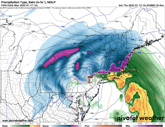
Another strong low pressure system will develop across the Southeast and make its way up the East Coast on Sunday. There is still some uncertainty with the exact track that the storm will take, but for now it looks like it may stay near the coast or just inland, passing directly over, or just west, of our area on Monday, though this is subject to change. This track would result in snow changing to sleet and/or freezing rain and then plain rain across much of the area. However, this is far from a guarantee. There are still some models that bring the storm a little farther south and east, which would result in more snow and less rain, but as we’ve mentioned numerous times, the models have been less than trustworthy beyond 2 or 3 days recently. When (or if) a change to mix and/or rain occurs will also have a significant impact on how much snow accumulates. Given the amount of uncertainty, it’s still WAY too early to try and pin down any potential accumulations, but it’s safe to say that the farther north and west of Boston you are, the better the chance you’ll need to fire up the snowblower or find your shovels. We’ll try to post an update this weekend, once we have some better clarity on the storm.
Thursday night: Partly to mostly cloudy, rain may develop across Cape Cod towards daybreak. Low 26-33.
Friday: Mostly cloudy, rain likely across Cape Cod and southeastern Massachusetts, possibly changing to snow before ending, becoming windy. High 35-42, but temperatures will start to quickly drop in the afternoon.
Friday night: Clearing, windy, and much colder, except partly cloudy with a few snow showers across Cape Cod. Low -3 to +4, except milder across Cape Cod and the Islands.
Saturday: Partly to mostly sunny, breezy, and very cold, except partly sunny with a few snow showers across Cape Cod. High 10-17.
Saturday night: Clear skies with diminishing winds. Low -2 to +5, except milder across Cape Cod and the Islands.
Sunday: Sunshine to start the day, clouds move in during the afternoon. High 23-30.
Sunday night: Cloudy and becoming breezy with snow developing, possibly rain across Cape Cod. Low 14-21.
Monday: Snow, possibly changing to sleet/freezing rain/rain, especially the farther south and east you go. High 39-46.
