This shouldn’t be a surprise, since it’s mid-December, but it’s going to snow this weekend.
After a mild day, a cold front will approach the region tonight, but only a few stray showers will accompany it. The front moves through early on Friday, but we’ll remain mild before a stronger push of colder air moves in late in the day as high pressure starts to build in across southern Canada. As we get to Saturday, low pressure will begin moving out of the Midwest and head towards New England, while a secondary area of low pressure develops south of New England. Exactly where this low tracks will help us determine how far north the warmer air will push, which is a key part of the forecast.

Snow should develop across the region towards midday or a little thereafter. A very quick change to rain is expected across the South Coast, if it doesn’t start as rain there. The rain/snow line should quickly move northward during the rest of the afternoon and evening. The evening and overnight is where things get tricky. The warmer air likely only gets as far north as the Mass Pike or possibly Route 2. However, we’ll also have warmer air moving in aloft, which means a change to sleet or freezing rain is possible across northern Massachusetts and possibly southern New Hampshire, even if it doesn’t all change to plain rain. Any changeover will have a significant impact on snow amounts. As the low moves away early Sunday, a change back to snow is possible before everything winds down toward daybreak. High pressure then builds in with sunshine and cooler conditions for Sunday afternoon and Monday.
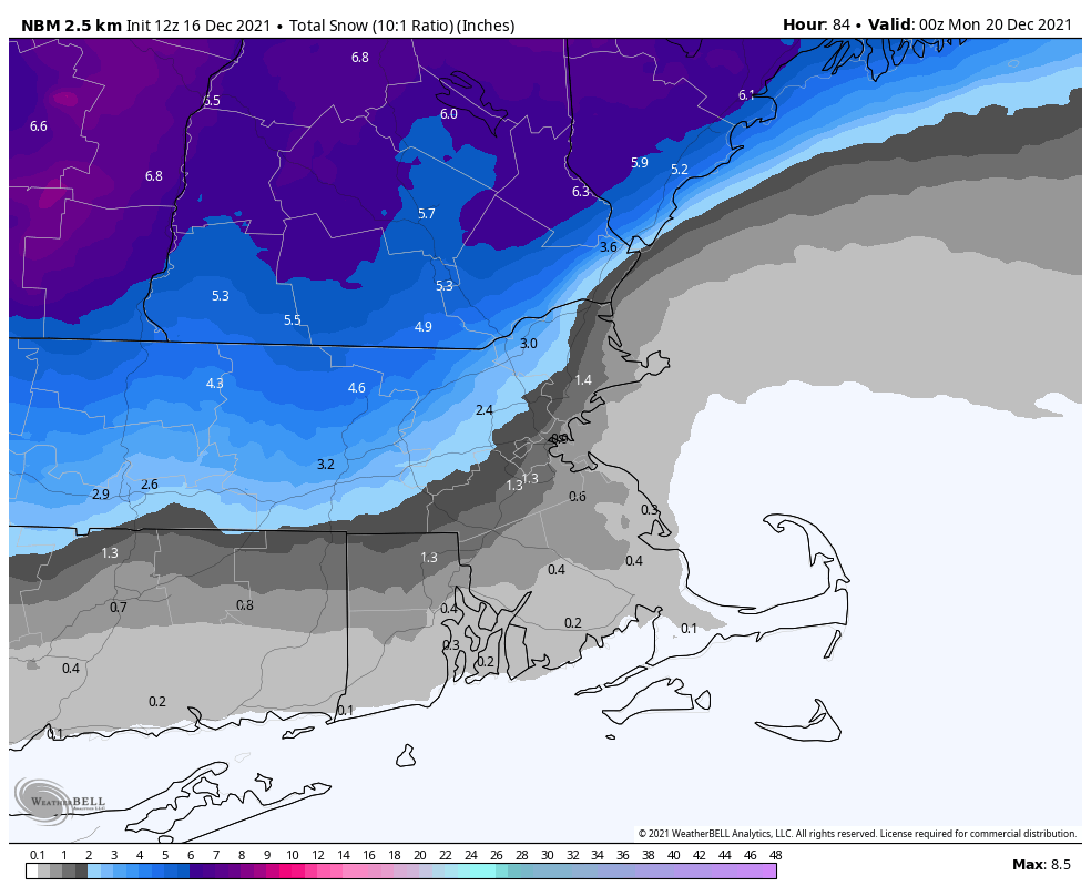
So, how much are we looking at? There are plenty of models out there showing a decent snowstorm, especially across the interior. We’re not buying it. We think they’re underestimating the mild air aloft. A quicker change to sleet and/or rain than what some of the models are showing seems more likely, especially the farther south and east you go. So, having said that, here’s our thinking:
Cape Cod/South Coast: A few flakes
Points south and east of Interstate-95: 1″ or less
Metro West/North Shore: 1-2″
Merrimack Valley/NH Seacoast: 1-3″
Southern NH/Central MA: 3-5″
Central NH: 4-7″
Thursday night: Mostly cloudy and breezy, slight chance for a shower, some clearing late. Low 44-51.
Friday: Becoming mostly sunny and breezy, high clouds start to stream back in late in the day. High 50-57.
Friday night: Increasing and thickening clouds. Low 28-35.
Saturday: Cloudy with snow developing during the afternoon, quickly changing to rain along the South Coast. High 35-42.
Saturday night: Light snow across southern New Hampshire, changing to sleet and freezing rain across northern Massachusetts, and plain rain elsewhere. Low 27-34.
Sunday: Rain or snow showers ending around daybreak, clearing in the afternoon. High 34-41.
Sunday night: Clear and colder. Low 12-19.
Monday: Sunshine and some afternoon clouds. High 27-34.
