It’s coming. You know what we’re talking about. It’s that time of year. You’re not going to like it, but you’re going to have to deal with it. No, we’re not talking about the non-stop Black Friday sales ads or the constant barrage of holiday music. It’s something more insidious. That four-letter word most of you hate. It begins with the letter “S”. And it’s in this forecast.
Before we get to that, let’s talk about Thanksgiving. The high pressure area that provided us with chilly weather yesterday and today will slide offshore tonight and Thanksgiving Day, allowing milder air to start to move into the region. However, a strong cold front will also be approaching from the west. Thanksgiving will start off with some sunshine, but clouds will stream in and thicken up during the afternoon and evening. A few showers are likely Friday morning into early afternoon before the cold front finally moves offshore. High pressure then moves in for Saturday and Sunday with the chilly weather returning along with sunshine. By Sunday afternoon though, clouds will start to stream back into the region ahead of the next storm system.

A Saskatchewan Screamer (it’s not an Alberta Clipper, since it originates in Saskatchewan) will dive into the Northern Plains and across the Midwest over the weekend, and by Sunday night, it will move off the Mid-Atlantic coastline. This much seems fairly certain. From here, there are a lot of things that we’re not terribly confident in, so we’ll give you our thoughts and best estimate right now, and will refine it this weekend, if need be. At this point, 1 of 3 things is likely to happen:
- The storm continues east-northeast, passing out to sea well to our south with minimal impact here.
- The storm turns more toward the northeast, bringing a period of light rain or snow here as it heads towards Atlantic Canada while strengthening.
- An approaching upper-level trough of low pressure captures the low, allowing it to hang around longer, and it brings a period of heavier snow and/or a wintry mix to the region, especially north and west of Boston.
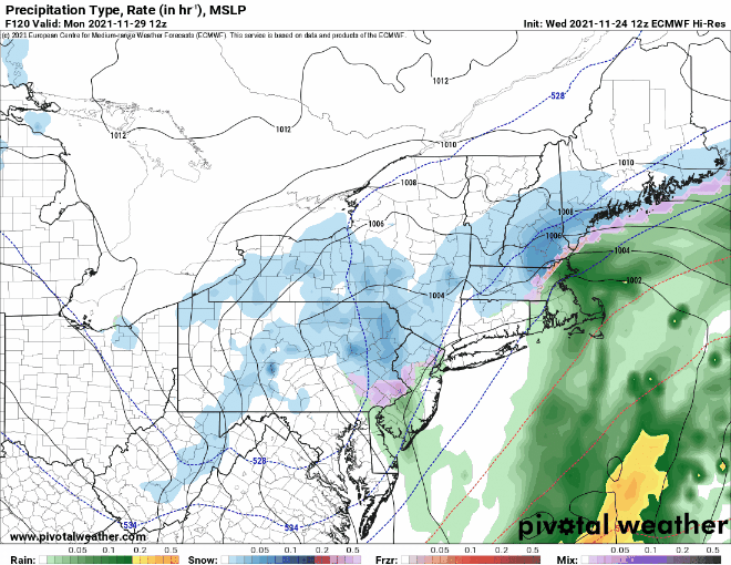
Depending on which forecast model you look at, any of these scenarios is possible. For now, we’re leaning towards scenario number 2. Precipitation should develop Sunday night and continue into Monday. It may start as rain for much of the region with snow north and west of Boston. Some sleet and/or freezing rain could mix in across the interior, with a change to all snow possible into Boston and points south as the system pulls away later on Monday. It’s WAY too early for any kind of estimate of accumulations, especially with the uncertainty in the forecast, but if (and that’s a big “if”) our thinking is in the ballpark, we’d be looking at the potential for a few inches north and west of Boston. There are some models predicting a very significant snowstorm, and you won’t have to look too hard on social media to find them, as all of the “weather weenies” are excited for the first potential “big” storm of the season. We prefer to deal with what we know, and not deal in hype. If this does look like it will materialize, we’ll have another blog post about it this weekend.
Wednesday night: Mostly clear skies. Low 22-29.
Thanksgiving: Morning sunshine, then clouds stream in. High 47-54.
Thursday night: Mostly cloudy. Low 32-39.
Friday: Cloudy with some showers likely, mainly during the morning and early afternoon, becoming breezy in the afternoon. High 41-48.
Friday night: Partly to mostly cloudy and breezy. Low 23-30.
Saturday: Becoming mostly sunny, breezy, and chilly. High 34-41.
Saturday night: Clear skies. Low 20-27.
Sunday: Some early sun, then clouds return. High 35-42.
Sunday night: Cloudy with light snow or rain developing from southwest to northeast. Low 23-30.
Monday: Cloudy with a chance of snow or a wintry mix north and west of Boston, chance of rain, possibly mixed with a little wet snow south. High 32-39 north and west of Boston, 39-46 south of Boston.
