Weekend Outlook: November 5-8, 2021

We’ve got a fairly easy forecast coming up for the next several days, so let’s get right to it.

High pressure will build in and keep the region dry and cool into the weekend, with some moderation expected by the end of the weekend and start of next week as the high slides offshore. There are only two potential flies in the ointment. We’ve got a low pressure area passing south and east of the region late tonight and Friday. It may pass close enough to spread a few showers into Cape Cod and possibly southeastern Massachusetts, but the vast majority of the region will stay dry. Whether or not there are clouds (and/or some light rain), will have a big impact on temperatures. Areas north and west of Boston should radiate tonight, with lows dropping well into the 30s, perhaps even some 20s again. Across southeastern Massachusetts, clouds and possibly rain will keep temperatures in the upper 30s and lower 40s. If the storm is farther offshore, then the clouds likely will be too, resulting in temperatures ending up a little cooler than what this forecast shows. Another system will pass offshore late Sunday night and Monday. This system looks to be even farther offshore, so it shouldn’t be much of a concern.

Temperatures could get back to 60 by Monday. Image provided by WeatherBell.

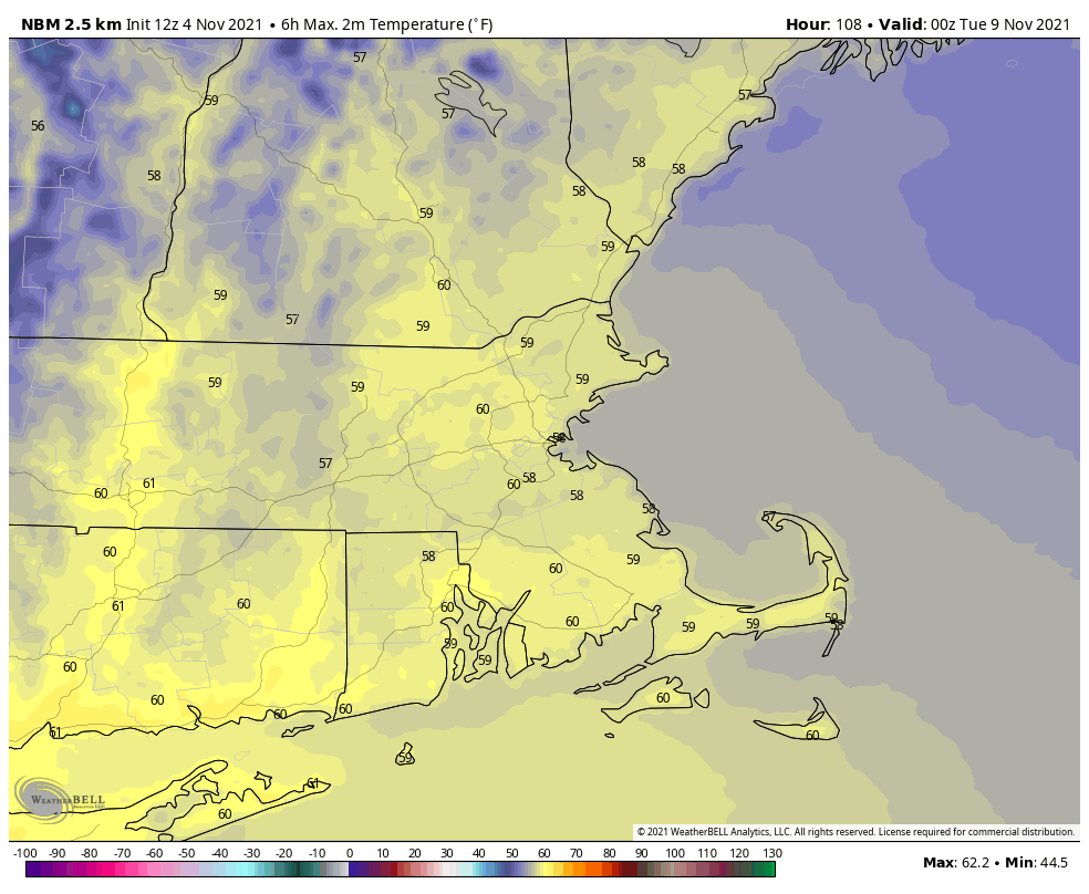
Thursday night: Partly to mostly cloudy, chance for a few showers across Cape Cod. Low 28-35, except 36-43 across Cape Cod and parts of southeastern Massachusetts.

Friday: Chance for a shower across the Cape during the morning, otherwise skies gradually become partly to mostly sunny. High 46-53.

Friday night: Mostly clear. Low 26-33.

Saturday: Sunshine and a few clouds. High 47-54.

Saturday night: Clear to partly cloudy. Low 28-35.

Sunday: Partly sunny. High 49-56.

Sunday night: Partly to mostly cloudy. Low 33-40.

Monday: Becoming mostly sunny and milder. High 53-60.

Weekend Outlook: October 29-November 1, 2021

The weather will cooperate with cleanup operations from this week’s storm, but another one is lurking on the horizon. Luckily, this one won’t be as strong.

High pressure remains in control into Friday with mostly dry weather and diminishing winds. There will be plenty of cloudcover from Boston southward, as low-level moisture remains in place tonight, while areas north and west of Boston get rather chilly under clear skies. Clouds stream in on Friday ahead of the next storm system. That system will come at the region from the southwest, and not up the coast. It should pass north and west of the region on Saturday, resulting in much milder conditions. Winds may be a little gusty out of the southwest, but we’re talking about gusts of 20-30 mph, not the 75-95 mph we saw Tuesday night and early Wednesday. The main issue with this storm will be rainfall. Rain will develop early Saturday morning, and continue for much of the day. The rain will be heavy at times during the afternoon and evening, but should taper and end by daybreak Sunday. We’ll see some clearing on Sunday, but as an upper-level disturbance crosses the Northeast, clouds will return, and a few pop-up showers are possible. High pressure then builds in for Monday with dry and mild conditions.

Another 1-2 inches of rain is expected this weekend. Some models show even heavier amounts are possible. Image provided by WeatherBell.

Thursday night: Clear to partly cloudy north and west of Boston, partly to mostly cloudy south of Boston. Low 33-40 north and west of Boston, 41-48 south.

Friday: Becoming partly to mostly cloudy. High 49-56.

Friday night: Cloudy with rain developing, mainly after midnight. Low 42-49.

Saturday: Breezy with periods of rain, possibly heavy at times. A rumble of thunder is possible, especially across southeastern Massachusetts and Cape Cod. High 57-64.

Saturday night: Rain gradually tapers off and ends. Low 48-55.

Sunday: Becoming partly sunny, chance for a shower or two during the afternoon. High 58-65.

Sunday night: Clearing. Low 43-50.

Monday: Partly to mostly sunny. High 57-64.

Weekend Outlook: October 22-25, 2021

It may be sunny and warm this afternoon, changes are coming, so enjoy it while you can.

Low pressure moving into southeastern Canada will send a cold front our way tonight. Ahead of it, a few showers are possible late tonight and early Friday, but the bulk of the rain with the system should stay well to our north and west. The cold front moves through on Friday, and although it will still be on the mild side, colder air will start to move in behind the front. High pressure settles in for the weekend with dry and much cooler conditions. Meanwhile, that cold front will be stalled out just south of New England, so even though most of us will be dry, we’ll still have some clouds around, especially the farther south you go. Could there be a shower or two across the Islands? Maybe, but it’s not a sure thing. We’ll also have an upper-level low pressure area passing north of the region. This will also generate some clouds as well, and possibly a pop-up shower or two each afternoon. Again, nothing to cancel plans over, but don’t be shocked if you see a few raindrops.

Temperatures at midday Saturday will be 10-18 degrees cooler compared to midday Friday. Image provided by WeatherBell.

Monday is where things become less certain. An area of low pressure moving out of the Ohio Valley will ride eastward along our stalled out front. Will it pass close enough to spread some rain into the region or will the high pressure area push it far enough to the south that it doesn’t have any impact? The forecast models have been all over the place with this idea, but for now, we’re leaning toward the drier scenario, but will put the chance of showers in the forecast just to cover ourselves. The second half of next week is looking quite wet at this point, but we’ll worry about that Monday morning with our Weekly Outlook.

The models don’t agree on whether Monday will be wet or dry. Images provided by Pivotal Weather.

Thursday night: Partly to mostly cloudy, chance for a few showers after midnight. Low 54-61.

Friday: More clouds than sunshine, any showers end early. High 66-73.

Friday night: Partly to mostly cloudy. Low 45-52.

Saturday: Partly sunny and cooler, slight chance for a shower. High 56-63.

Saturday night: Becoming mostly clear. Low 37-44.

Sunday: Morning sunshine, clouds return in the afternoon. High 54-61.

Sunday night: Mostly cloudy with a chance for showers, especially south of Boston. Low 39-46.

Monday: Plenty of clouds with showers possible, mainly south of Boston. High 52-59.

Weekend Outlook: October 15-18, 2021

Fall is the season of change, and changes are coming this weekend in terms of the weather.

High pressure remains in control into Friday with another warm day expected under partly sunny skies. However, a strong cold front is marching eastward, and it will arrive on Saturday. Ahead of it, a warm front will move through Friday night, perhaps accompanied by a few showers. Saturday will be breezy and warm, but we’ll have plenty of clouds, with showers developing by late afternoon. Showers and some thunderstorms are likely through the evening, but should end before daybreak Sunday as the cold front finally crosses the region. Behind the front, breezy and much cooler conditions are likely for Sunday and Monday. While it will feel almost chilly at times, these temperatures will be right around normal for mid-October. Both Sunday and Monday will feature some sunshine, but with an upper-level disturbance moving through, we’ll have clouds developing, and just a slight chance for a shower each afternoon.

Temperatures at midday Sunday will be 10-15 degrees cooler than at midday Saturday. Image provided by WeatherBell.

Thursday night: Partly to mostly cloudy. Low 53-60.

Friday: Intervals of clouds and sun. High 68-75, possibly a little cooler along the coast.

Friday night: Plenty of clouds, chance for a few showers. Low 57-64.

Saturday: A few sunny breaks, mainly early, but generally cloudy and breezy with showers possible late in the day. High 69-76.

Saturday night: Scattered showers, possibly some thunder as well. Low 49-56.

Sunday: Any lingering showers end early, otherwise a mix of sun and clouds, breezy, slight chance for an afternoon shower. High 60-67.

Sunday night: Clear to partly cloudy. Low 42-49.

Monday: Partly sunny, chance for an afternoon shower. High 54-61.

Weekend Outlook: October 8-11, 2021

Columbus Day Weekend has arrived, but it still won’t feel quite like fall just yet for the entire weekend.

High pressure remains in control through the 1st part of Friday with dry and mild conditions, but a backdoor cold front will drop down the coast, bringing cooler weather in for Friday night and Saturday. There may even be some drizzle or a few showers around at times too. High pressure builds back in for Sunday, but we’ll have to keep an eye on low pressure south of New England. There is still some question as to whether the rainfall from this system makes it into our area Sunday night and Monday. We’ll include the chance for showers in the forecast for now, but the most likely spot for any rain will be along the South Coast.

Most of the models aren’t terribly enthusiastic about the rain chances for Sunday night and Monday. Images provided by Pivotal Weather.

Thursday night: Clear skies. Low 48-55.

Friday: Sunshine gives way to increasing afternoon clouds. High 66-73.

Friday night: Mostly cloudy with some patchy drizzle or a few showers. Low 47-54.

Saturday: Clouds and a few sunny breaks, some spotty drizzle or a shower are still possible. High 59-66.

Saturday night: Mostly cloudy. Low 47-54.

Sunday: Plenty of clouds. High 61-68.

Sunday night: Partly to mostly cloudy with a chance of showers, mainly near the South Coast. Low 50-57.

Monday: More clouds than sun, showers are possible again, mainly near the South Coast. High 66-73.

Weekend Outlook: October 1-4, 2021

Most of the upcoming weekend should be pretty good weatherwise, but probably not all of it.

An upper-level low pressure area will pull away tonight, but a few showers are still possible through the first part of the night, mainly near the coastline. High pressure builds in for Friday into Saturday with drier conditions. While Friday should feature a decent amount of sunshine, Saturday will likely have more clouds as a weak system passes by to the north. Could it produce a few showers? Maybe, but mainly in southern New Hampshire.

Friday morning will be on the chilly side. Image provided by WeatherBell.

Sunday is when things get really tricky. A low pressure area will be slowly moving in from the west, sending a warm front toward the region. The question is, how far north does the warm front get before stalling out? This will have a large impact on temperatures. Our best estimate at this point is that it will at least get up to the Mass Pike, but beyond that, we’re not sure. South of the warm front, it will be warm and humid, with temperatures likely getting into the 70s. North of the front it may stay in the upper 50s and lower 60s. The next question is – when does the rain move in? Right now, it looks like we may have some showers late Sunday afternoon and evening ahead of the warm front, but that isn’t set in stone at this point. Late Sunday night into Monday do look wetter, but again, this is far from a lock.

Sunday’s temperatures will be determined by how far north the warm front gets. Images provided by Pivotal Weather.

Thursday night: Mostly cloudy with a few showers possible this evening, then skies clear out overnight. Low 40-47.

Friday: Sunshine and some afternoon clouds. High 60-67.

Friday night: Partly to mostly cloudy. Low 43-50.

Saturday: More clouds than sun, slight chance for a sprinkle across southern New Hampshire. High 65-72.

Saturday night: Partly to mostly cloudy, slight chance for a shower, mainly across southern New Hampshire. Low 50-57.

Sunday: Mostly cloudy, chance for a few late-day showers. High 59-66 north of the Mass Pike, 67-74 south of the Pike.

Sunday night: Mostly cloudy with showers developing. Low 53-60.

Monday: Mostly cloudy with scattered showers. High 62-69.

Weekend Outlook: September 24-27, 2021

Some rain is on the way, but much of the weekend looks decent weatherwise.

A slow-moving cold front will make its way across the region tonight and Friday, bringing plenty of clouds in, with some rain likely, mainly on Friday. A few rumbles of thunder are also possible. We’re not expecting a widespread heavy rain like we had at times for most of the summer, but don’t expect to see much, if any, sunshine on Friday. The front pushes offshore Friday night, but showers may linger into Saturday morning across eastern Massachusetts. While there may be some sunshine developing, especially well west of Boston, during Saturday afternoon, clouds will linger in the east. Another wave of low pressure will ride up that front offshore, but will likely pass close enough to bring some rain back in for Saturday night and Sunday morning. This is a relatively new development in the models, but it shows up on several models, so we’re inclined to go with it. We should start to clear out again on Sunday, but an upper-level feature will be moving across the region, and it may kick off another shower or two during the afternoon. High pressure builds in for Sunday night and Monday with drier conditions.

Most of the heavy rain will be confined to western New England. Image provided by Weathermodels.com

In the tropics, Tropical Storm Sam has developed over 1700 miles east of the Lesser Antilles. It is sat least 5 days away from potentially threatening any land areas, but Sam will definitely be a storm to watch. Most of the models develop Sam into a powerful hurricane over the weekend and early next week. Sam should continue on a west-northwest track across the Atlantic through the weekend. Beyond that? It’s still way too early to speculate on where Sam may go.

Forecast track for Tropical Storm Sam. Image provided by the National Hurricane Center.

Thursday night: Partly to mostly cloudy with a few showers possible. Low 64-71.

Friday: Cloudy with scattered showers, possibly a thunderstorm. High 71-78.

Friday night: Mostly cloudy, showers ending from west to east. Low 55-62, a little milder across Southeastern Massachusetts and Cape Cod.

Saturday: Intervals of clouds and sun, chance for a few showers, mainly in eastern Massachusetts. High 68-75.

Saturday night: Mostly cloudy with more showers possible. Low 53-60.

Sunday: Any lingering showers end early, then becoming partly sunny with a chance for a late-day shower. High 68-75.

Sunday night: Clear to partly cloudy. Low 49-56.

Monday: A mix of sun and clouds. High 67-74.

Weekend Outlook: September 17-20, 2021

Improving weather is coming, but it will take a little while to get here this weekend.

A frontal system will wash out along the South Coast tonight and Friday while high pressure tries to build in. The result will be mainly dry conditions, but still plenty of cloud cover, especially along the South Coast. Temperatures will remain on the cool side compared to the last few days thanks to northeast to east winds, but we should still see most places get into the 70s.

Skies are clearing out not far to our north and west, Meanwhile, low pressure is trying t organize off the Carolina coast. Loop provided by NOAA.

Meanwhile, an area of low pressure off the Carolina coast is trying to organize this afternoon and it could become a tropical depression or even a weak tropical storm over the next day or so. It will move northward and then northeastward, passing well south and east of us Friday night and Saturday. However, it will bring some gusty northeast winds to coastal areas, and churn up the seas again, resulting in some rough surf and rip currents at the beaches.

Forecast tracks for the disturbance off the Carolina coast from the various members of the GFS Ensemble. Image provided by Weathernerds.org

A weak cold front will also be moving in on Saturday, with a few showers possibly accompanying it. For later Saturday into Sunday and Monday, we’ll have high pressure building in, which means sunshine and mild temperatures, which is about as good as it gets for the final weekend of astronomical summer. Fall begins with the autumnal equinox at 3:20pm next Wednesday.

Average high temperatures in mid-September are in the lower to middle 70s around here. Image provided by Weathermodels.com

Thursday night: Mostly cloudy, chance for a few showers across the South Coast and Cape Cod. Low 58-65.

Friday: Partly to mostly cloudy. High 70-77.

Friday night: Partly to mostly cloudy. Low 60-67.

Saturday: A mix of sun and clouds, slight chance for a shower, mainly well north and west of Boston. High 72-79.

Saturday night: Mostly clear. Low 57-64.

Sunday: Plenty of sunshine. High 69-76.

Sunday night: Clear skies. Low 50-57.

Monday: Unlimited sunshine (daylight hours only). High 71-78.

Weekend Outlook: September 10-13, 2021

We have got an absolutely fantastic stretch of weather on tap for the upcoming weekend.

Sunday is looking like a rather warm day for mid-September. Image provided by WeatherBell.

Before we get to the nice weather, we’ve got some rain tonight as a cold front crosses the region. The rain will end from west to east tonight, and skies will start to clear out by daybreak. On Friday, we’ll have an upper-level disturbance moving through. So we’ll start off with sunshine, but clouds will develop, and a few pop-up showers are possible. We’ll clear out again Friday night as high pressure builds in. With clear skies and light winds, we’ll have radiational cooling, which could result in a rather cool night in some spots. Saturday will feature sunshine and mild temperatures. As the high slides offshore, we’ll warm up on Sunday, just in time for the Patriots season opener in Foxborough. Another cold front will move through on Monday with some clouds and a few showers. There is the chance that Monday may not be as nice as we’re currently forecasting it to be. Some of the newer model runs are going for a cloudy day with more rainfall and cooler temperatures. This is a shift from what they had been previously been showing, so we’re not going to jump on that bandwagon yet, but we’re keeping an eye on it.

Will it rain Monday? Some models say yes, some don’t. We’ll see what happens. Images provided by Pivotal Weather.

Thursday night: Showers ending followed by some clearing late at night. Low 57-64.

Friday: Sunshine and some afternoon clouds, maybe a shower or two. High 68-75. Offshore: Northwest wind 10-15 knots, gusts to 20 knots, seas 3-6 feet, up to 6-9 feet in the waters south and east of Cape Cod and the islands.

Friday night: Clear and cool. Low 49-56.

Saturday: Sun, sun, and more sun. High 69-76. Offshore: West winds 5-15 knots, seas 3-5 feet, up to 5-8 feet in the waters east of the Cape and Islands.

Saturday night: Clear skies. Low 57-64.

Sunday: Sunshine and a few clouds. High 76-83. Offshore: West to southwest winds 10-20 knots, seas 3-5 feet.

(Kickoff Forecast for Foxborough: Sunny, temperature near 80, southwest winds 10-15 mph.)

Sunday night: Partly to mostly cloudy. Low 60-67.

Monday: Intervals of clouds and sun, chance for a few showers. High 74-81. Offshore: West to southwest winds 10-20 knots, seas 3-6 feet.

Weekend Outlook: September 3-6, 2021

After yet another deluge, the unofficial end of summer will feature mostly dry weather.

Over the past 60 days, most of the region has received 2-3 times the normal amount of rainfall. Image provided by WeatherBell.

High pressure builds in tonight with dry and cool conditions. Friday will remain mostly dry with high pressure in control, but an upper-level low will slowly pull away and a disturbance riding around it will produce some clouds, and possibly a sprinkle or shower Friday afternoon. The high slides offshore on Saturday, keeping us dry, but temperatures will start to warm up once again. A weak frontal system moves through on Sunday with plenty of clouds, and a few showers Sunday afternoon and night. The system pulls away on Labor Day and high pressure builds back in, with dry and seasonably warm conditions returning.

Labor Day looks it will be seasonably warm once the skies start to clear out. Image provided by Weathermodels.com

Thursday night: Clear and cool. Low 49-56.

Friday: Sunshine and some afternoon clouds, chance for a sprinkle or shower during the afternoon. High 66-73. Offshore: Northwest winds 5-15 knots, seas 2-4 feet.

Friday night: Becoming mostly clear. Low 51-58.

Saturday: Plenty of sunshine. High 71-78. Offshore: Northwest to west winds 10-15 knots, seas 2-4 feet.

Saturday night: Increasing clouds. Low 53-60.

Sunday: Mostly cloudy, showers possible late in the day. High 70-77. Offshore: Southwest winds 10-15 knots, gusts to 20 knots, seas 2-4 feet.

Sunday night: Cloudy with occasional showers. Low 59-66.

Labor Day: Any showers end early, becoming partly sunny in the afternoon. High 74-81. Offshore: Southwest winds 5-15 knots, seas 3-5 feet.