Record Highs, Blizzard Conditions, and Severe Weather – February in the Nation’s Midsection

“In the Spring, I have counted 136 different kinds of weather inside of 24 hours.” – Mark Twain

It’s not quite spring yet, but this quote is still appropriate. Much of the nation’s midsection has been enjoying temperatures more typical of April than February for the past week, with a few hundred record high temperatures broken. That is about to change, as Mother Nature will remind the region that is still February.

ndfd_record_hi_mc_1
Numerous record highs are expected across the Plains and Midwest again today. Image provided by WeatherBell.

Of course, they will still have one more warm day today, with highs well into the 60s and 70s likely setting more records. However, a cold front will sweep across the region, bringing an end to the record heat, and setting the stage for a snowstorm.

The low pressure system that brought more rain to California over the past couple of days will head eastward, bringing some snow into the Rockies today. As that system moves into the Plains on Thursday it will start to strengthen, drawing moisture northward from the Gulf of Mexico while cold air flows southward on the backside of the storm into the Northern Plains. Where these airmasses meet, snow will develop across the Central Plains states. The snow will be accompanied by winds of 20-30 mph, gusting to 40 mph or more at times, resulting in near-blizzard conditions across portions of South Dakota, Nebraska, southeastern Wyoming, and eastern Colorado on Thursday.
snku_acc-us_nc
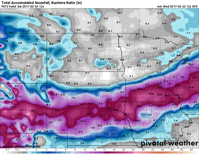
More than a foot of snow may fall in a swath from the Plains into the Upper Midwest. A lot of these same places are going to be in the 60s and 70s today. Image provided by Pivotal Weather.

As the system heads eastward, snow will move into portions of the Mississippi Valley and the Upper Midwest on Friday. The heaviest snow looks to stay just south of the Twin Cities, but even there, moderate to heavy snow is likely. By the time the storm moves out on Saturday, a foot or more of snow is possible in a swath from the Central Plains into the Great Lakes.

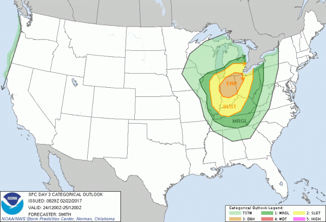
Snow isn’t the only threat from this system. As the storm moves eastward, record warmth will remain in place across the Midwest. With warm, moist air in place and a strong cold front approaching from the West, strong to severe thunderstorms are possible across portions of the Lower Great Lakes and Ohio Valley on Friday. Some of the stronger storms that form may contain damaging winds, hail, and possibly tornadoes.
day3otlk_0830
The Storm Prediction Center has already highlighted the Midwest as an area to watch for severe weather on Friday. Image provided by NOAA.

The system will continue to move eastward, bringing some rain to the East Coast on Saturday, which may cause problems for hockey fans in the Steel City. The next NHL Stadium Series game (Ed – Enough with the outdoor games already. It jumped the shark a long time ago), is scheduled for Saturday at 8pm between the Pittsburgh Penguins and Philadelphia Flyers. The daytime hours will likely be mild with rain, but the rain may change to snow late in the day as temperatures tumble. Either way, it won’t be a pleasant night for fans to be sitting in the stands at Heinz Field. Here at Storm HQ, we despise the Flyers, so we hope their fans not only have to sit through the weather, but watch their team get thumped too.

scott-wilson-jpg-size-custom-crop-819x650
That’s former UMass-Lowell RiverHawk (and StormHQ favorite) Scott Wilson hoisting the Stanley Cup last June. Image provided by Toronto Star.

Once it gets past Pittsburgh, that front will head eastward, bringing some rain to us here in New England. It probably won’t be a lot of rain, but temperatures will be in the 50s and possibly 60s ahead of the front on Saturday. Once the front comes through, Sunday will be windy and colder.

Here We Snow Again

We had a blizzard on Thursday and some light snow this morning. So, you’re all set with snow for a while, right? Good, you get a 24-hour break. We’ve got another storm coming for Sunday and Monday, and this one is looking like it will be another significant one.

Low pressure currently moving across the Plains states will move into the Ohio Valley tonight, then off the Mid-Atlantic coastline later on Sunday, passing just south of New England. It is then expected to slow down in the Gulf of Maine Sunday night and Monday while rapidly intensifying. Cold air is already in place today, and some spotty freezing drizzle or flurries are possible this evening into Sunday morning. The steadier precipitation from the storm should arrive around midday Sunday, in the form of snow, and may quickly become moderate during the afternoon hours. A coastal front will likely set up once again, with temperatures in the lower to middle 30s to the east of it, and upper teens to lower 20s west of it. As this front pushes inland, snow will change to rain during the late afternoon  or evening from Boston southward. Inland, we may see a little freezing rain or sleet mix in, but it should be mainly snow. As the storm begins to intensify in the Gulf of Maine Sunday night and Monday, this coastal front will collapse back towards the coast, changing everything back to snow, as gusty northerly winds send cold air back across the region. Snow continues into Monday morning, before tapering off around midday, though some snow showers may continue into the afternoon.

nam-refcmp_ptype-us_ne-2017021112-loop
Forecast from the NAM model for the upcoming storm. Loop provided by Pivotal Weather.

Having said all that, there are still a few details to be worked out:

1. How close does the storm come to the South Coast/Cape Cod.
2. How rapidly does the storm intensify in the Gulf of Maine.
3. How close to the coast does the storm slow down in the Gulf of Maine.

We need to resolve the factors to get a truly accurate forecast, but unfortunately, most of that won’t be known until the storm is ongoing. We are fairly sure that the strong winds will be confined to coastal areas, and mainly on Monday as the storm really intensifies to the east. Sustained winds of 25-35 mph with gusts to 50 mph or more are possible, especially from Cape Ann to the South Shore and Cape Cod.

So, by now, you’re wondering, how much snow this time? Here’s what we’re thinking:

Cape Cod: 1-3″, mainly Monday from the backlash behind the storm.
South Shore/Boston/Providence: 4-8″, possibly a little more, especially the further inland you get
MetroWest: 5-10″
Merrimack Valley: 8-12″
Southern NH/MA North Shore: 10-14″
NH Seacoast/Southern Maine: 12-16″

hires_snow_boston_61
The High Resolution NAM model most closely resembles our forecast for the upcoming storm. Image provided by WeatherBell.

We may revise this forecast late tonight or Sunday morning, if time allows. Also, just to give you fair warning, we may be dealing with yet another snowstorm in the Wednesday/Thursday time frame.


More Snow This Weekend?

Have you finished cleaning up your driveway from the blizzard yet? Good, because we’ve got a 1-2 punch coming this weekend with more snow, though the 2nd storm, while stronger, may end up as rain for a portion of the area.

latest_snow_anal_box
How much snow actually fell during yesterday’s blizzard. Our forecast worked out almost perfectly. Image provided by National Weather Service – Taunton.

Don’t let today’s sunshine fool you, it’s going to snow again tonight. A Saskatchewan Screamer (also known as an Alberta Clipper) will race this way, spreading clouds back in late today. There will be little wind associated with this storm, so we’ve got that going for us. Light snow will develop around midnight and continue through the morning, tapering off an ending around midday. Most of us will see between 1 and 3 inches from this storm, with a few 4 inch totals possible. That’s not a big deal, right? Especially after what we got yesterday.

hires_snow_boston_37
Just some light snow is expected late tonight and Saturday morning. Image provided by WeatherBell.

After that, we turn our attention to Sunday, because that might be a bigger deal. That storm, like so many of the other ones we’ve had this winter, will likely not be all snow for everyone. However, where it does stay all snow, we could be looking at several inches of heavy, wet snow – the kind that nobody likes to shovel.

Low pressure will head into the Ohio Valley then towards the eastern Great Lakes this weekend. It will then redevelop off the Mid-Atlantic coastline and head east-northeastward, passing near or over Cape Cod, because really starting to intensify in the Gulf of Maine. How close it comes to the Cape and how quickly it starts to intensify are the biggest things that will impact our forecast. We’ll try to iron out those details in the next 24 hours, and have another post tomorrow, after the first system winds down.

Snowy Thursday Expected

“Luck. Runs. Out.” – Metallica

If you’ve been enjoying the relatively snowless and mild winter, then the opening line to the Metallica song “All Nightmare Long” is an appropriate line today, because your luck has run out. We’ve got a snowstorm coming tomorrow, and it’s going to impact both the morning and evening commutes, so plan ahead.

A cold front is moving across the region this afternoon, replacing last night’s unexpected cold air with milder air. Yes, that doesn’t sound right, but it’s what’s actually happening. As it moves offshore, it will stall out south of New England and high pressure will build in to our north, replacing the relatively mild air of this afternoon with more seasonably cold conditions tonight. At the same time, a wave of low pressure will ride along our stalled out cold front across the Tennessee Valley and into the Mid-Atlantic states. Once it moves off the coast early Thursday, it will intensify as it passes south and east of New England. With cold air settling in, and low pressure passing just south of New England, you get a snowstorm. It won’t be a blockbuster storm, since it’ll be moving too quickly, but we’re still looking at moderate to heavy snow.

gfs-prateptype_cat-us_ne-2017020812-loop
GFS model forecast for the progression of our Thursday storm. The darker blues are moderate to heavy snow. Loop provided by Pivotal Weather.

OK, time for some specifics. First the timing. This will be a 10-12 hour storm for most of us. The snow should develop right around the morning commute, roughly the 6-8am time frame. It should end right around the evening commute, roughly the 6-8pm time frame. The worst of the storm will be between about 10am and 4pm, when snow could fall at the rates of 1-2 inches (or more) per hour.

Next up – temperatures, since they have an impact as well. We’re going to have a boundary set up across eastern Massachusetts that is called a coastal front. We had the same thing happen last night. East of the front (right along the coast), temperatures will be in the upper 20s to lower 30s, resulting in a wet, heavy snow. West of the front, temperatures will be in the upper teens to lower 20s, resulting in a much drier, fluffier snow. Right along this boundary is usually where the heaviest snow falls. So, where does that front set up? Right now, it looks like somewhere right along I-95 across eastern Mass.

hires_t2m_boston_30
Temperature forecast for Noon Thursday based on the WRF model. Note the sharp temperature gradient across eastern and southeastern Massachusetts. Image provided by WeatherBell.

Next up, the winds. Strong winds will likely be confined to eastern Massachusetts, especially along the coast, as always. Sustained winds of 20-30 mph are possible near the coast, with some gusts to 50 mph. Away from the coast, we’re looking at gusts of 20-30 mph. Nothing like some of the worst storms we’ve seen, but it’ll creating blowing and drifting, reducing visibility at times.

So, that leads us to the part you’re all most interested in – how much snow are we going to get? For most of us, this will be a moderate snowfall event. Here’s the breakdown for what we’re thinking:

Central NH (Concord): 3-6″
Southern NH (Manchester/Nashua/Portsmouth): 4-8″
Merrimack Valley/Central MA (Lawrence/Lowell/Fitchburg/Worcester): 5-10″
Cape Cod: 5-10″ (maybe a little less on the Outer Cape/Nantucket)
North Shore/SE Mass (Beverly/Plymouth/Fall River): 6-12″
Rest of Eastern MA/RI (Boston/Providence/Brockton/Framingham): 7-14″ with isolated heavier totals possible.

6zgfs
This model (the GFS) most closely resembles our thinking for snowfall across the region. Image provided by Pivotal Weather.

Once the storm goes by, we’re looking at a breezy and cold day on Friday, with temperatures likely staying in the teens or lower 20s across the entire area. Then, Friday night and Saturday brings another Saskatchewan Screamer (Manitoba Mover? Albert Clipper?) which could drop a quick 2-4 ” of snow. There’s another storm right behind that for Sunday night into Monday, but the models are indicating that storm could feature more rain than snow. We’ll keep an eye on it anyways. The active pattern likely continues into next week as well.

Wintry Mess Tonight and Wednesday?

Another storm system is set to move into the region later today and into Wednesday. While this one will produce a wintry mess across parts of the area, for the majority of us, it won’t be a big deal.

namussfcwbg
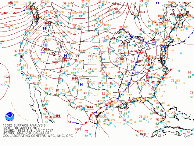
Current surface map as of 10am EST Tuesday. Image provided by NOAA.


A low pressure system is currently moving into Michigan. This is the same system that brought heavy snow to the central and southern Rockies and a significant ice storm to the central and southern Plains and parts of the Mississippi valley over the past few days. This storm will head towards the eastern Great Lakes this evening and start to weaken, while at the same time, a secondary area of low pressure will develop south of New England.

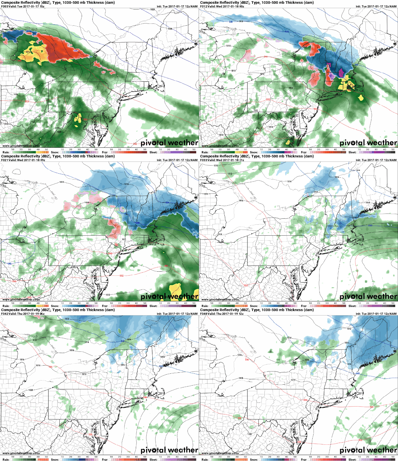
12z-nam
NAM Model forecast for the next 48 hours across the Northeast. This model is closest to our thinking for this storm. Loop provided by Pivotal Weather.


Along and south of the Mass Pike, this is mainly a rain storm. Rain will develop around dinner time this evening, might be heavy overnight, and will taper off to showers or drizzle Wednesday morning, but likely doesn’t end until Wednesday evening. For Western and Central New England, we have bigger issues.

zr_acc-us_ne
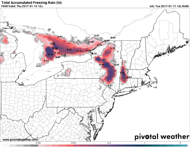
Freezing rain forecast through Thursday morning across the Northeast, Image provided by Pivotal Weather.

Across the Berkshires, Catskills, and Adirondacks (and possibly the higher elevations of the Monadnocks and Worcester Hills), we’re looking at freezing rain, possibly a lot of it. Temperatures aloft will warm above freezing, but a thin layer of colder air will remain just above the surface. Since that layer is the ground layer in the hills, it will fall as freezing rain. Driving along I-90 through the Berkshires and also west of Albany out to about Utica could be very slick later today into early Wednesday. As the secondary storm takes over early Wednesday, colder air will move back in, changing the freezing rain over to snow, with a little accumulation possible.

raipzrsn
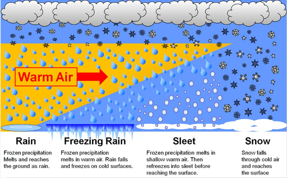
This graphic shows the difference in how you get snow vs sleet vs freezing rain. Image provided by NOAA.


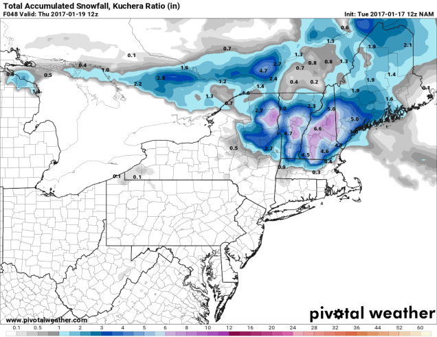
Meanwhile, we’re looking at some snow across portions of central and southern Vermont and New Hampshire and into southwestern Maine. In areas that stay all snow, mainly across central New Hampshire and Vermont, we could see as much as 4-8 inches fall by the time the storm winds down late Saturday. The tricky forecast is from coastal Maine and New Hampshire into southern New Hampshire and northern Massachusetts. In these areas, precipitation likely starts as snow this evening, but a change to sleet and eventually rain should take place overnight tonight or Wednesday morning, with a change back to snow possible late Wednesday as the system starts to wind down. How long that change takes will have a big effect on how much snow accumulates. Right now, it looks like we could see as much as 3-5″ near Manchester, NH, dropping down to 2-4″ around Nashua, and maybe an inch or less across the Merrimack Valley and the Seacoast, including Lowell, Lawrence, and Portsmouth. As you can see, with such a sharp gradient between several inches and virtually nothing, only a slight shift in the forecast can have a big difference in what actually falls across these areas.

snku_acc-us_ne-1
Snowfall forecast through Thursday morning. Image provided by Pivotal Weather.


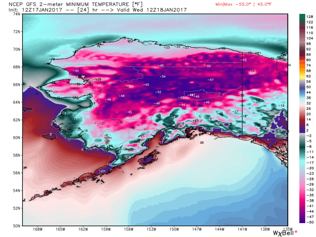
The good news is that there isn’t much colder air following this storm. Temperatures will remain near to a little above normal for much of the remainder of the week, with highs mainly in the 30s and 40s. Contrast that with Alaska, where low temperatures for the next several mornings will range from 25 to 55 below zero across much of the state.

gfs_t2min_alaska_5
Brutally cold air has settled into Alaska and will remain in place for much of the week. Image provided by WeatherBell.


“Great White Plague” Takes Aim on Southeast and New England

A developing storm system will bring heavy snow to parts of the Southeast and New England this weekend, while the West Coast braces for a lot of much-needed rainfall.

gfs_mslp_pcpn_frzn_wus_fh6-192
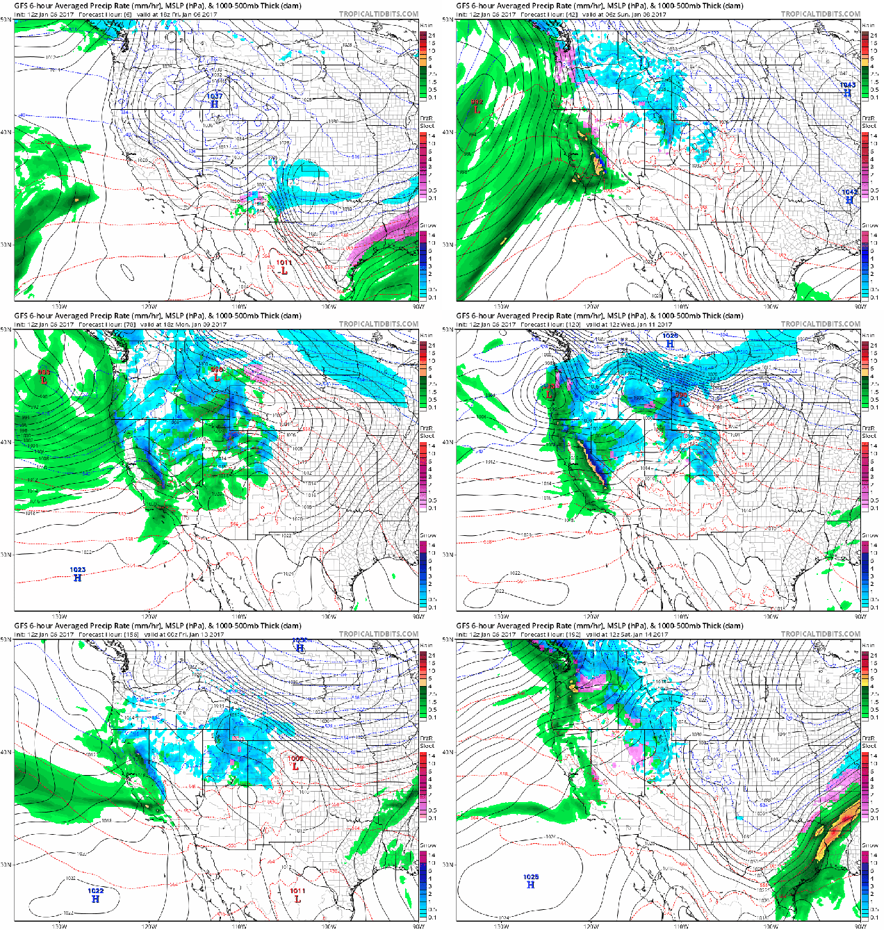
A parade of storms will assault the West Coast this week. Loop provided by Tropical Tidbits.

We’ll start on the West Coast, where a series of storm systems will bring plenty of rain to drought-stricken California. While this will not alleviate the drought that has been ongoing for years, it will help to put a big dent into it. The first of the storm systems will move in tonight, and by the time the last one moves through next Friday, rainfall totals of 5-10 inches will be widespread across much of central and Northern California, with many locations, especially along the coast and western slopes of mountains receiving 10-20 inches or more.

gfs_6hr_snow_acc_norcal_33
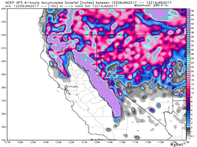
Snowfall totals of 6-12 feet are possible across the Sierra Nevada over the next week. Yes, we said feet, not inches. Image provided by WeatherBell.

At the higher elevations, especially in the Sierra Nevada, incredible amounts of snow are expected. The snowpack, which much of the region depends on for water in the summer as it melts, is already above normal, and over the next week, some locations might see 6-12 FEET of new snow from these storm systems.

snku_acc-us_ma
GFS model forecast for snow across parts of the Southeast and Mid-Atlantic states through Sunday morning. Image provided by Pivotal Weather.

Back in the East, a storm system is riding along a stalled out front across the Southeast, producing some snow across parts of the Tennessee Valley and the Southeast. As this system draws in moisture from the Gulf of Mexico and the Atlantic, and runs into an arctic airmass already settling into the region, it will produce heavy snow in places that normally don’t see a lot of snow, such as Georgia, the Carolinas, and the Virginia Tidewater area. In these places, even a dusting of snow can cause traffic nightmares, so heavy snow can bring these areas to a standstill, which is why one friend of the blog in the Raleigh area refers to it as “The Great White Plague”.

The heaviest snow from this system is expected across the Appalachians, as you’d expect, and into the Virginia Tidewater area, as the storm gathers strength while moving into the Atlantic. Of course, the 6-12 inches expected across much of North Carolina will cause its own problems, but luckily, the bulk of the snow will fall tonight and Saturday, minimizing the travel problems.

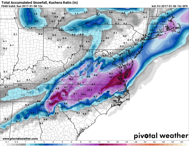
Once this storm moves off the Mid-Atlantic coast it will head northeastward, passing a couple of hundred miles south and east of Cape Cod. Normally, this would mean just a little bit of light snow for parts of Southern New England, and for the most part, that’s what we’re expecting. However, for southeastern New England, mainly south and east of I-95, it’ll be a different story from Saturday afternoon into Sunday morning.

There are a couple of factors that will enhance snowfall totals across this region. First, with northeasterly winds blowing off the Atlantic, we’ll get some ocean-effect snowfall. This is similar to the lake-effect snow that you often see near the Great Lakes. While we’re not going to get buried like Buffalo does, it will add a bit more snow than we’d normally see with a storm like this. Second, it’s going to be cold out. Now, this might seem like an obvious statement because it’s winter and it’s always cold. What we mean is that temperatures will only be in the upper teens to middle 20s. This means that it will be more of a fluffy snow, which will pile up quicker than a much wetter snow. We already saw this with the light snow that fell earlier this morning.

The snow should start to develop across Cape Cod and southeastern Massachusetts Saturday morning, and will quickly spread inland. The snow should spread as far inland as Worcester and southern New Hampshire, but it will quickly retreat eastward again, ending in most places during the evening. The exception is Cape Cod and parts of Plymouth County, where northerly winds behind the storm may keep the ocean-effect snow going into the early hours of Sunday morning.

n-east_nam218_sfc_accum-snow-plots_72hr
NAM Model forecast for snowfall through Sunday evening. Image provided by Earl Barker’s Weather Models.

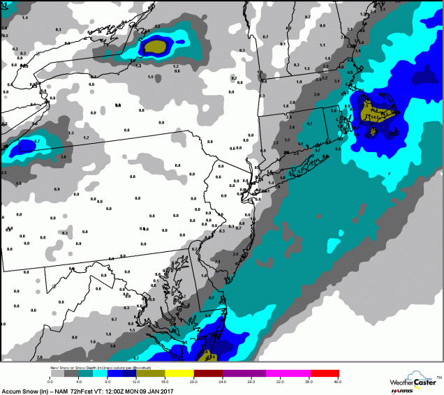
The NAM model is probably the closest to what we are thinking for snowfall. As you can see from the map above, we’re not expecting more than an inch or two from southern New Hampshire into Central Massachusetts. Points north and west of Boston and Providence, including the Merrimack Valley, will likely see 2-5 inches. Along and south of Interstate 95, including the southern and eastern suburbs of Providence and Boston, we’re thinking 6-10 inches, with the best chance for more than 10 inches of snow across parts of Plymouth County and Cape Cod, where the ocean enhancement will play a big role.

Behind the system, with fresh snow cover, temperatures will get even colder. Monday morning, temperatures will be in the single numbers across much of the region, with some sub-zero readings likely. The next storm moves in later on Tuesday, and although it will start as some snow or a wintry mix, milder air will move in, with the bulk of the precipitation falling in the form of rain Tuesday night into Wednesday.
This Ride Probably Won’t Thrill You

“Get in, sit down, shut up, and hold on” – Toby Keith

Ladies and gentlemen, please make sure your safety belts are securely fastened, as this rollercoaster is ready to go. Yup, the weather will go through several changes over the next few days, giving us a little of everything – howling winds, bitterly cold wind chills, snow squalls, sleet, freezing rain, heavy rain, unseasonably mild temperatures. And that’s just before the weekend is over.

We’ll start with Thursday. A series of arctic cold fronts will cross the region. Some snow squalls may accompany the fronts, so you’ll need to be prepared for that if you’re out and about during the day. These are the winter equivalent of summer thunderstorms. They’re impossible to predict ahead of time, usually don’t last too long, but can have severe impacts if you get caught in one. Visibility can drop to near zero in an instant, a quick inch or two of snow could accumulate, and the next town over could see nothing at all.

winds
Very strong winds are likely Thursday night behind the cold front. Might be a good idea to bring some of those Christmas decorations inside for a few days. Image provided by National Weather Service – Taunton.

While the snow squalls can be a high-impact but localized event, the strong winds and bitterly cold temperatures will be felt region-wide. Northwest winds of 15-30 mph are likely, with gusts upwards of 50-60 mph possible, especially Thursday afternoon into Friday morning. High Wind Watches have been posted for parts of the region. If you have any loose objects outside, such as trash barrels, Christmas decorations, small children, etc, you may want to consider bringing them inside, so that they don’t blow away.

gfs_t2min_boston_9
GFS model forecast for low temperatures across the region Friday morning. Yes, those are in Fahrenheit, not Celsius. Image provided by WeatherBell.

These gusty winds will also usher some of the coldest air so far this winter into the region. Most days, the day starts off cool, warms up until mid-afternoon, then cools off again as the sun goes down. Thursday will not be one of those days. We’ll start the day with temperatures in the 30s, but temperatures will drop into the 20s by midday, then keep dropping. By Friday morning, most places will see temperatures in the single numbers, with some sub-zero readings possible. When you factor in the wind, the wind chill will be 15 to 25 below zero in many areas. Make sure you’re all bundled up if you have to head outside for any reason at all. Better yet, stay inside, it’s easier.

sfctwc-us_ne
Wind chills of 15 to 25 degrees below zero are expected Friday morning, Bundle up if you have to head outside for anything. Image provided by Pivotal Weather.

The good news is, the cold air will be short-lived. The bad news is, the transition from the arctic air will be rather messy. A storm system will head up the St. Lawrence Valley this weekend. Precipitation will develop ahead of this system before sunrise Saturday morning. That precipitation will start as snow, but as warmer air moves in aloft, it will start to change over. How quick that changeover occurs is the big question mark.

gfs_mslp_pcpn_frzn_neus_fh60-120
GFS model forecast for the progression of a storm system across the Northeast this weekend. Loop provided by Tropical Tidbits.

Cold air will likely remain entrenched at the surface, especially away from the coastline. With warm air moving in aloft, that means we’ll likely see a changeover to sleet and/or freezing rain across the interior Saturday afternoon. Along the coast, a quick change to rain is likely, as water temperatures remain in the 40s, which will help warm things up fairly quickly near the shoreline. Eventually, that warmer air will move in at the surface across the entire area, with a change to plain rain expected overnight. Before that changeover happens, we’ll probably see snowfall accumulations of 1-3″ south and east of I-95, including the Boston and Providence metropolitan areas. North and west of I-95, we’re looking at 2-5″ of snow, with the possibility of some sleet or ice accretion. Please keep this in mind if you have plans in this region Saturday afternoon/evening.

gfs_t2max_boston_17
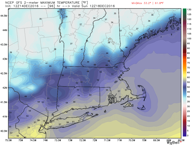
Temperatures will be quite mild when you wake up Sunday morning, but more changes are coming. Image provided by WeatherBell.

OK, so it warms up Saturday night and everything changes to rain. End of story, right? Nope, the ride isn’t over yet. By Sunday morning, temperatures will be in the 40s to lower 50s north and west of Boston, with 50s and possibly even some 60s from Boston southward. So, Sunday will be a nice warm day, right? Nope. Temperatures will peak in the morning, then drop again throughout the day as the system drags a strong cold front across the region. In fact, if the rain is slow to depart, it could change back over to some snow or sleet before ending in the afternoon. It probably won’t accumulate, but with wet roads and sharply falling temperatures, we could see some black ice develop on many area roadways. Again, just one more thing to keep in mind in you are heading out and about late Sunday afternoon or evening.

Things start to calm down after that. Monday will be quite chilly again, with highs only in the 20s, and gusty winds keeping wind chills close to zero. Temperatures start to moderate next week, and a late-week system could bring in some rain. Right now, it’s not looking like a White Christmas, but things can still change. Beyond that? Well, the GFS model gave us a good laugh this afternoon.

gfs_mslp_pcpn_frzn_neus_51
The GFS model is having delusions this afternoon. Sure, it’s a possibility, but we’re not putting much stock in this forecast. It is fun to look at though. Image provided by Tropical Tidbits.

Snow in the Forecast? Not for Most of Us

By now, you’ve probably heard from your favorite TV meteorologist that there’s snow in the forecast for Thursday. While parts of the region will likely see some snow on Thursday, the vast majority of us will not.

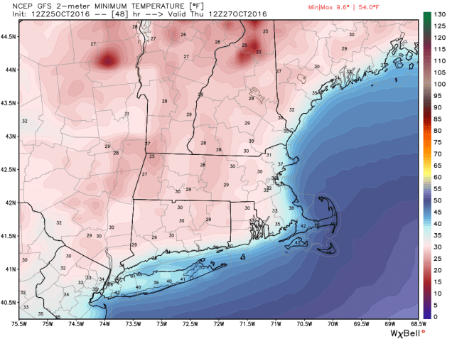
High pressure will provide us with some chilly weather for the next few days. Temperatures will likely dip near or below freezing across much of the area tonight and again Wednesday night. So, we’ve got cold air in place, and a storm system heading our way on Thursday. That means it’s going to snow, right? As famed college football analyst Lee Corso would say “Not so fast my friend”. Allow us to explain.

gfs_t2min_boston_9
Thursday morning will start off with temperatures below freezing across much of the region. Image provided by WeatherBell.

As that high pressure area moves off to the east, winds will shift into the east and southeast across the region. Water temperatures off the coast are still in the 50s to lower 60s, so a wind off the water will allow temperatures to moderate. Thursday will still be a chilly day, with temperatures mainly in the 40s, but the air will remain dry, thanks to the high pressure area. As the precipitation arrives from the west during the afternoon, it will fall into that dry air, evaporating before it hits the ground. This will also allow temperatures to drop through a process called evaporational cooling. Temperatures may drop into the upper 30s to lower 40s before the air moistens up enough for the precipitation to hit the ground.

qpf_acc-us_ne
GFS model forecast for rainfall through Friday afternoon. Image provided by Pivotal Weather.

With temperatures likely near or just above 40, we’re looking at mainly rain across most of our region. Oh sure, there could be a renegade snowflake or ice pellet mixed in at the start across parts of southern NH or central MA, but for the most part, we’re looking at rain, and possibly a decent amount of it. Much of the region could receive between 0.75″ and 1.50″ of rain from this system, which will help put a dent into the ongoing drought.

Farther to the north and west, especially across the higher elevations of the Berkshires, Monadnocks, and the mountains of Northern New England, temperatures will be cooler, and the precipitation will arrive faster, thus increasing the chances that it starts as snow. Even in these locations, warmer air will move in Thursday night, allowing the snow to change over to rain. Before that happens, we could see a little accumulation, especially at the higher elevations, where a few inches may accumulate. The best chance for accumulating snow actually looks to be across the Adirondacks of northeastern New York, where the warm air will have a tough time getting in.

gfs_6hr_snow_acc_neng_13
Snowfall forecast from the GFS through Friday morning. Image provided by WeatherBell.

Once we get past this system, we could be looking at a wet weekend and start of next week. A couple more storms may move across the region, bringing us several bouts of much-needed rainfall. It does not look like there will be more snow with these systems, except possibly across the mountains of northern New England.

A Little Bit of Everything – October in the Northeast

October can be a time of change in the Northeast. While the first thing that comes to mind is the changing colors of the foliage across the region, the weather also changes, sometimes quite frequently. That’s what we’re going to be dealing with for the next few days.

rtma_t2m_neng
Current temperatures across the Northeast as of 1pm on October 19. Image provided by WeatherBell.


It’s an unseasonably warm afternoon across much of the Northeast, with temperatures generally in the 60s and 70s, with 80s from southern Connecticut into the Mid-Atlantic states. Dozens of record highs have been set over the past few days, and more are falling today. However, some changes are coming, and the warm weather will be a distant memory within the next 24-48 hours.

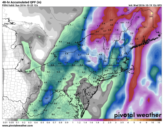
A cold front is moving across the region this afternoon, though you really couldn’t tell, as there’s only scattered cloud cover and little precipitation with the front. That front will stall out to the south of New England tonight. On Thursday, a wave of low pressure will start to approach from the west. This will spread rain and showers into the region. Some of the rain will be heavy, especially from New York into Pennsylvania late Thursday into Friday. With rainfall totals of 1-3 inches and locally up to 5 inches expected, some flooding is likely. Across New England, where a serious drought is ongoing, rainfall will be much lighter, with most locations likely receiving under half an inch of rain.

qpf_acc-us_ne
Expected rainfall through Friday evening across the Northeast. Image provided by Pivotal Weather.


As that wave of low pressure moves into Upstate New York on Friday, it will lift that cold front back across New England as a warm front. While Friday won’t be as warm as today, temperatures will still get into the 60s and lower 70s across much of New England. With dewpoints also in the 60s, it will be a rather muggy day for mid-October.

99l_tracks_latest
Computer model forecasts for the track of a tropical disturbance in the Bahamas. Image provided by Tropical Tidbits.


Meanwhile, there is a tropical disturbance brewing in the Bahamas right now. While conditions are favorable for development, we’re not looking at another monster like Matthew, it could become a tropical depression or subtropical storm over the next few days. The system will likely head northward, moving towards the Gulf of Maine as we head into the weekend. This will bring another round of heavy rainfall into Maine and Atlantic Canada, again missing most of Southern New England, where the rain is most needed.

qpf_048h-us_ne
Expected rainfall between Friday morning and Sunday morning across the Northeast. Image provided by Pivotal Weather.


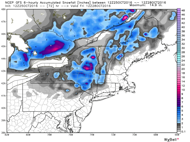
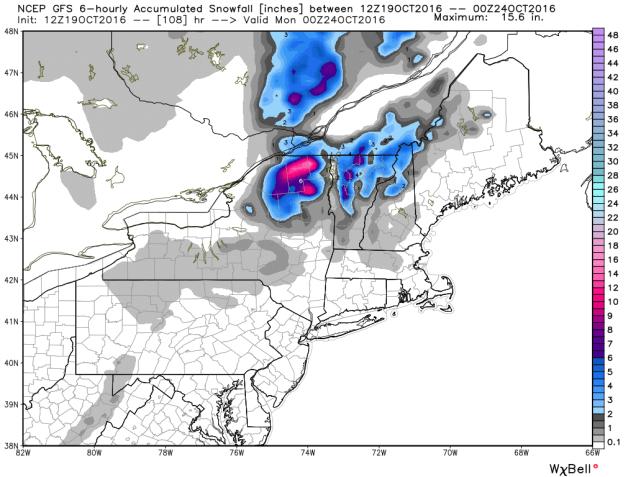
Once the system moves into southeastern Canada, it is expected to stall out under an upper-level low pressure area and become a strong extratropical system. It will drag a cold front across the Northeast, bringing much colder air into the region. With strong low pressure nearby and much colder air filtering in, rain will change over to snow across portions of Upstate New York and Northern New England. While the snow will be confined mainly to the higher elevations, this is the first accumulating snow of the season across the area. Several inches may accumulate across parts of the Adirondacks and the Green Mountains.

gfs_6hr_snow_acc_neng_19
Expected snowfall through Sunday evening across the Northeast. Image provided by WeatherBell.


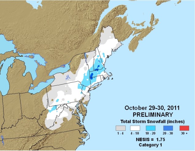
While there could be a few wet flakes mixed in with some of the rain across lower elevations of Central New England, accumulating snow is not expected.Sunday will be a chilly day, with highs only in the 40s and 50s across much of the Northeast. These readings are 10-20 degrees below normal. Of course, any mention of snow in October across the Northeast will make residents think back just a few years to the pre-Halloween snowstorm that dropped 1-2 feet of snow across parts of the region, setting numerous records. While this system won’t come anywhere close to that, it should make for some spectacular photos of snow-capped mountains and valleys filled with colorful foliage early next week.

20111029-20111030-1-75
Snowfall from the Halloween snowstorm of 2011. Image provided by NOAA.


Weekly Outlook October 3-9, 2016

There’s not much going on in the weather world right now is there? OK, we’re know you’re not that naive. We’ll get to the update on Matthew in a moment. Much of the remainder of the forecast is actually pretty simple.

The gloomy pattern we’ve been in will continue for one more day before the upper-level low pressure system responsible for it finally lifts out. High pressure starts to build in on Tuesday, and we stay dry through Friday.

After that? Well, that’s the $64,000 question, isn’t it? Here’s what’s going to be happening with the atmosphere. A cold front will start to approach from the west, while an upper-level trough of low pressure moves from the Plains states into the Great Lakes. By early Saturday, Matthew should be off the North Carolina coastline.

gfs_z500_mslp_eus_23-1
GFS forecast for Saturday morning October 8. Note the trough of low pressure (green colors) moving into the Mississippi Valley, the ridge of high pressure off the East coast (red and orange colors), and Matthew just off the NC coast. Image provided by Tropical Tidbits.

How strong that trough is, as well as how strong the ridge of high pressure off the East Coast is, will determine where Matthew goes. The GFS (pictured above), sends the storm north-northeastward, as the trough pulls it in. Other models, such as the ECMWF, do not have a strong trough, and as such, it builds the ridge back in, stalling Matthew’s northward progress, and letting it mill around off the Carolina coast for a few days. Other models don’t build up the ridge to the east, and thus let Matthew head northeastward, farther out to sea, before the trough captures it and pulls it northward well east of New England. The upper-level energy that will help determine how deep that trough gets is still off the West Coast. Once it gets into the West Coast, and an area where there is a lot more data to feed into the models, they should start to converge on a solution, and thus give us a better idea, or at least a little more confidence, as to what will happen.

12_es1
GFS Ensemble forecast tracks for Hurricane Matthew. Image provided by Dr. Brian Tang, University at Albany.
12_es3
ECMWF Ensemble forecast tracks for Hurricane Matthew. Image provided by Dr. Brian Tang, University at Albany.

Before we get to what, if any, impacts Matthew may have on our area, there’s another problem. The models are picking up on this, but we don’t think they’re hitting it hard enough. We told you that a cold front would be coming in from the west. This is going to set up what is called a “Predecessor Rainfall Event” or PRE for short. This often happens up here ahead of tropical systems, and can even occur when the tropical system doesn’t even get within 500 miles of New England. This was the case with the devastating flooding we had in 1996 from Hurricane Lili and again in October of 2005. This also happened last year in South Carolina with offshore Hurricane Joaquin. In other words, even if Matthew does not come close to New England, we could be looking at extremely heavy rainfall around here on Saturday ahead of a cold front. Earlier this summer, we told you about an old rule of thumb “When in drought, leave it out”, when talking about rainfall. Well, we’ve got another rule of thumb for you “Droughts end in floods”. Just look at Texas from earlier this year to see that play out.

Monday: Partly to mostly cloudy with more showers and maybe even a rumble of thunder possible. High 64-71.

Monday night: Mostly cloudy, chance for a few more showers. Low 50-57.

Tuesday: Becoming partly sunny. High 58-65.

Tuesday night: Partly cloudy.  Low 44-51.

Wednesday: Partly to mostly sunny (yes, really, we mean it). High 60-67.

Thursday: Mostly sunny. High 65-72.

Friday: Sunshine and a few clouds. High 67-74.

Saturday: Becoming cloudy with rain developing. The rain could be heavy, especially at night. High 64-71.

Sunday: Cloudy with rain likely, possibly heavy at times. If Matthew is close enough, it will also be very windy. High 60-67.