It’s starting to feel like fall around here, but temperatures will warm up again, and some rain is on the way.

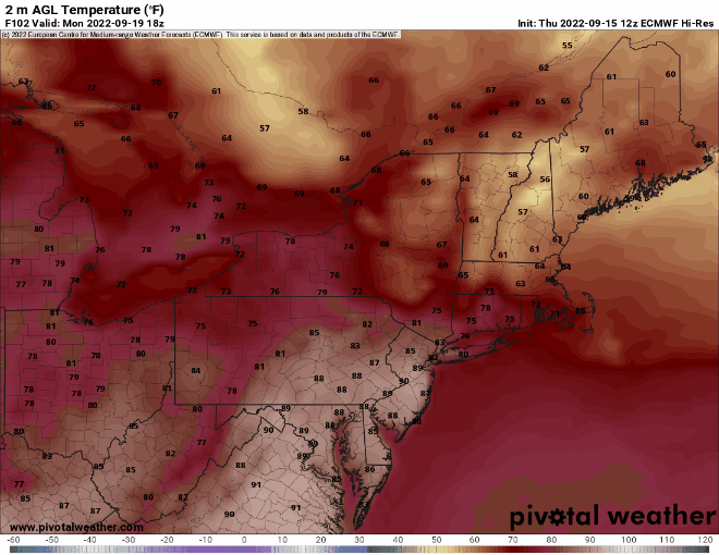
High pressure keeps the region dry and cool into Saturday before it finally pushes offshore. Some of the haze and smoke from the fires out West may drift across the region tonight and early Friday, which could result in a colorful sunrise Friday morning if you’re up that way. By Sunday, the high slides offshore, and we start to warmup, but clouds will also be moving in. Late Sunday and Monday is much more uncertain. A backdoor cold front is going to try and drop southward, but whether it actually gets here or not is something the models don’t agree on. Some showers may move in late Sunday ahead of the front, but they’ll be more likely on Monday as a wave of low pressure rides along that front. As for temperatures on Monday, they will be highly dependent on the location of the front. North of the front, temperatures may stay in the 60s, while south it will be in the 70s or even low 80s. For now, we’re leaning toward the warmer air being mainly south of the Mass Pike, with cooler conditions to the north, but this is obviously highly uncertain.
Meanwhile in the tropics, Tropical Storm Fiona has formed. As of 2pm, Fiona was centered about 465 miles east of the Leeward Islands, moving toward the west at 14 mph. Maximum sustained winds were near 50 mph. Tropical Storm Watches and Warnings have been issued for many of the islands in the northeastern Caribbean. The current forecast calls for some slow strengthening over the next few days, despite the presence of westerly wind shear. It is expected to track across the Leeward Islands late Friday, and pass very close to Puerto Rico and the US Virgin Islands Saturday into early Sunday. Beyond that, there are a number of scenarios, and depending on which model you believe, the storm could end up anywhere from the Gulf of Mexico to Bermuda to dissipated completely by this time next week.

Thursday night: Clear to partly cloudy, hazy at times. Low 44-51.
Friday: Mostly sunny. High 69-76.
Friday night: Clear to partly cloudy. Low 45-52.
Saturday: Partly to mostly sunny. High 68-75.
Saturday night: Partly cloudy. Low 56-63.
Sunday: Morning sun, increasing afternoon clouds, showers possible late in the day. High 77-84, but temperatures may drop quickly late in the day, especially from northeastern Massachusetts and southern New Hampshire northward.
Sunday night: Mostly cloudy, chance for a few showers, mainly during the evening. Low 58-65.
Monday: Plenty of clouds, with showers possible. High 65-72 north of the Mass Pike, 73-80 south of the Mass Pike.
