We got rid of the heat a couple of days ago, the humidity will follow soon.
A cold front will approach the region tonight, with just a couple of showers accompanying the front when it moves through early Friday. After that, high pressure builds in for the weekend with temperatures at or below normal, and significantly lower humidity levels. An upper-level disturbance will move through on Saturday which may trigger a stray shower or two, but most of us will remain dry. Sunday looks like the best day of the week bunch with warm and dry conditions and a good amount of sunshine.

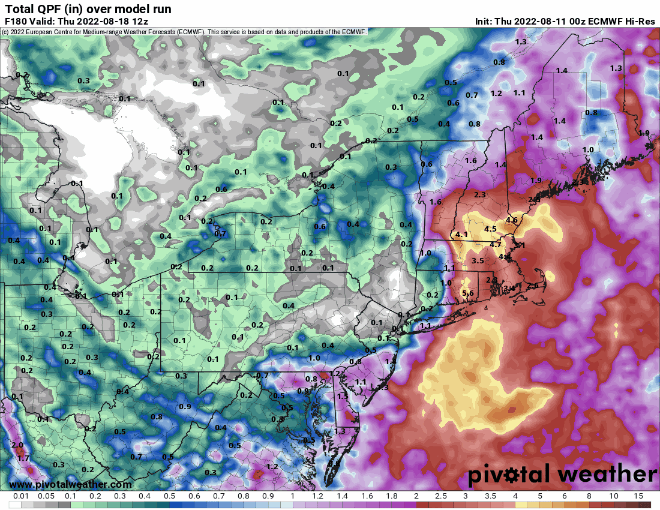
Monday is the transition day. Many of the models are showing the potential for some significant rainfall during the early to middle part of next week with an offshore low pressure system. Given recent trends and the ongoing drought, we are obviously skeptical that this will happen, but the models are in decent agreement for now. Assuming this trend continues, we’ll see clouds move in on Monday, with some showers possible by late in the day. We’ll obviously have more details and more confidence in what will happen when we publish our Weekly Outlook early Monday morning.
Thursday night: Partly to mostly cloudy, chance for a few showers, some patchy fog is possible, especially near the coast. Low 60-67.
Friday: A few lingering showers early, otherwise clouds and some sunshine, not as humid. High 75-82.
Friday night: Partly cloudy. Low 57-64.
Saturday: A mix of sun and clouds, slight chance for a shower. High 73-80.
Saturday night: Clear to partly cloudy. Low 56-63.
Sunday: Sunshine and some afternoon clouds. High 76-83.
Sunday night: Partly cloudy. Low 58-65.
Monday: Becoming mostly cloudy, showers may develop by late in the day. High 76-83.
