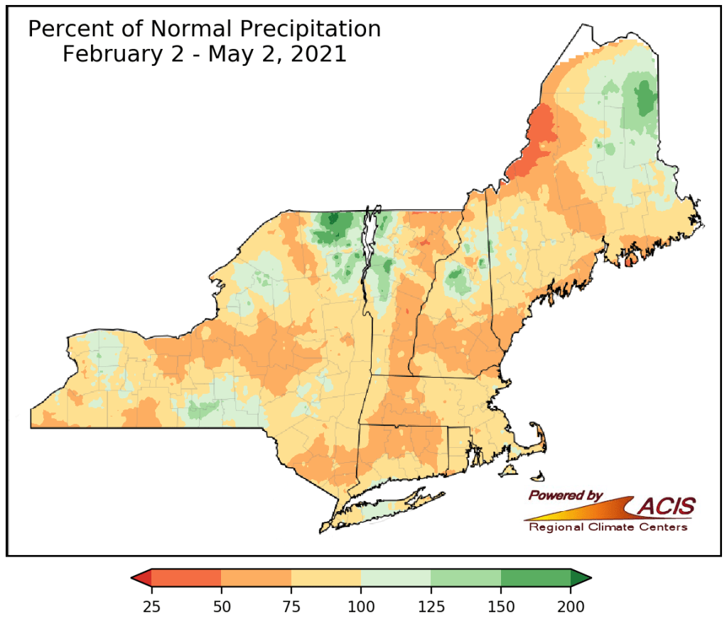
This is definitely not shaping up to be a great week to be on vacation, but it is shaping up to be a decent week to put another dent in our developing drought.
A cold front moved through late yesterday, and it will stall out south of the region today. With the front nearby, we’ll have plenty of clouds around today, with temperatures that are much cooler than we had on Sunday. We could see a few breaks of sun, but in general, clouds will dominate. By late in the day, we’ll see some more showers moving in as a wave of low pressure rides along that frontal boundary. Those showers should come to an end Tuesday morning, but again, we’ll still have lots of clouds around, with temperatures possibly becoming quite cool behind that wave. Another wave will approach during Tuesday night and Wednesday. This wave may lift the front northward, allowing milder air to move back in to at least part of the region. That wave moves offshore on Wednesday, bringing an end to the rain and dragging the front much farther offshore. High pressure then builds in for Thursday with some sunshine and seasonably mild temperatures. Thursday will definitely be the pick of the week.
As we head into the end of the week and the weekend, things get unsettled again. A coastal storm will likely impact the region, but the models don’t completely agree yet on what that impact will be, or exactly when it will be. Friday and/or Saturday will likely feature a period of rain, possibly heavy, some gusty winds, and cool temperatures. How much rain, how much wind, and how cool it will be are details that we don’t have a good handle on yet. In fact, at least one model shows the potential for some wet snow to mix in, especially over the hills of central New England. While this wouldn’t be unheard of this late in the season, we’re not expecting it to occur, though we’re not completely ruling it out either. As for next Sunday, the coastal storm should be out of the picture, but another system may be approaching from the west, as our active pattern is expected to continue for quite some time.

Monday: Plenty of clouds with showers possible late in the day. High 54-61 along the coast, 61-68 inland.
Monday night: Cloudy with showers likely. Low 44-51.
Tuesday: Showers end in the morning, remaining mostly cloudy in the afternoon. High 55-62, potentially turning much cooler during the afternoon.
Tuesday night: Cloudy with showers redeveloping. Low 43-50.
Wednesday: Showers ending by midday, some sunny breaks are possible late in the day. High 58-65, cooler along the coast
Thursday: A mix of sun and clouds. High 58-65.
Friday: Cloudy with showers possible. High 53-60.
Saturday: Partly to mostly cloudy, chance for showers. High 55-62.
Sunday: Mostly cloudy with a chance of showers. High 57-64.
