The heat is definitely on, and so is the humidity, but it’s not going to last. Oh don’t worry, we’re not looking at any “cool” weather, just a return to seasonably warm temperatures.
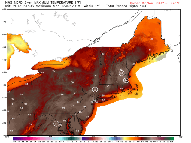
High pressure is sitting off the East Coast, but a cold front will start to approach from the northwest today. In between those two, southwest winds will pump hot and humid air into the region. Temperatures should soar into the 90s this afternoon away from the south coast. When you factor in the humidity, with dewpoints in the 60s to lower 70s, the heat index will rise into the 90s or lower 100s this afternoon, especially in the northern and western suburbs of Boston. So, if you’ve got outdoor plans, drink plenty of water, wear some sunscreen, and try to get inside to the air conditioning as much as possible.

If you do have outdoor plans today, we have another piece of advice for you – keep an eye to the sky. With that cold front approaching from the northwest, showers and thunderstorms will likely develop ahead of it this afternoon and evening. Some of the storms may contain heavy downpours and gusty winds along with frequent lightning. Getting a sunburn from being outside too long on a hot day is bad enough, but it’s nothing compared to being struck by lightning. As the saying goes “When thunder roars, stay indoors.”
The front finally pushes through early Tuesday morning, then high pressure builds in later Tuesday into Wednesday with drier and more seasonable conditions. However, another weak system may spread more clouds and possibly some showers into the region, especially south of Boston, Wednesday night into early Thursday. This shouldn’t be anything major, and we’re not completely convinced that there will be any rainfall at all. Since we’re not ready to rule it out either, we figured we’d mention the possibility.
This brings us to Thursday, specifically Thursday morning – 6:07am to be precise. That is the time of the summer solstice, the beginning of astronomical summer, and it should end up as a rather nice summer day. We may have some clouds around in the morning, but with high pressure building in, sunshine will return during the day. In fact, high pressure should remain in control through Saturday. Sunday, however, will probably not be as nice. Low pressure will pass to the north, bringing another cold front across the region. This will likely bring us more showers and some thunderstorms.

Monday: A mix of sun and clouds, breezy, showers and thunderstorms are possible late in the day. Humid. High 90-97, except 79-89 along the south coast and a short distance inland.
Monday night: Mostly cloudy with scattered showers and thunderstorms. Low 66-73.
Tuesday: Some early clouds, then becoming partly to mostly sunny and less humid. High 79-86.
Tuesday night: Clear to partly cloudy. Low 54-61.
Wednesday: A sunny start, some clouds move in late in the day. A few showers are possible at night, mainly south of Boston. High 80-87, cooler right along the south coast.
Thursday: Chance for an early shower, then skies become partly to mostly sunny. High 75-82, cooler right along the coast.
Friday: Plenty of sunshine with just some high clouds in the afternoon. High 77-84.
Saturday: Sunshine fades behind increasing and thickening clouds in the afternoon. High 78-85.
Sunday: Mostly cloudy with scattered showers and possibly some thunderstorms. High 74-81.
