Weekly Outlook: September 15-21, 2025

We’re not going to get much, if any, relief for the drought this week across the majority of the region, but temperatures should remain comfortable.
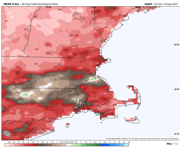
Over the past 90 days, rainfall totals across the region are roughly 2-5 inches below average normal. Image provided by WeatherBell.

We start the week off with high pressure in control, giving us a couple of dry and warm days for Monday and Tuesday, with a seabreeze keeping coastal areas a little cooler, especially today. Wednesday and Thursday are the days with the most uncertainty at this point. We’ll still have high pressure to the north, but a low pressure area will be passing offshore. This will send in some clouds, but similar to last week’s system the question is how far north the rain shield will get. Some models keep it all offshore, several bring it up to the South Coast, some bring in farther inland. Given then the models overestimated how far inland it would get with the system last week, we’re inclined to think that the rain probably won’t get much farther inland than the South Coast, with most of it falling Wednesday night into early Thursday. The system pulls away later Thursday, then a cold front drops down from the north on Friday. The models show most of the rain with the front drying up before it gets here, so the front should move through with little fanfare on Friday. Behind it, high pressure returns with much cooler air on Saturday, though temperatures should start to moderate a bit on Sunday.

Most of the models keep what little rain we’re expecting close to the South Coast late Wednesday into Thursday. Images provided by Pivotal Weather.

Monday: Areas of morning fog, otherwise partly to mostly sunny. High 71-78, a little cooler along the coast.

Monday night: Partly cloudy, areas of fog developing. Low 50-57.

Tuesday: A mix of sun and clouds. High 70-77, a little cooler along the coast.

Tuesday night: Partly to mostly cloudy. Low 50-57.

Wednesday: More clouds than sun, chance for a few showers, mainly near the South Coast. High 69-76.

Wednesday night: Partly to mostly cloudy, chance for a few showers near the South Coast. Low 54-61.

Thursday: Morning clouds, maybe a shower near the South Coast, becoming mostly sunny during the afternoon. High 75-82, a little cooler across Cape Cod.

Thursday night: Mostly clear. Low 55-62.

Friday: Partly to mostly sunny. High 76-83.

Saturday: Plenty of sunshine, cooler. High 63-70.

Sunday: Mostly sunny. High 65-72.
Weekend Outlook: September 12-15, 2025

We’ve got a couple of very nice days coming up across the region.

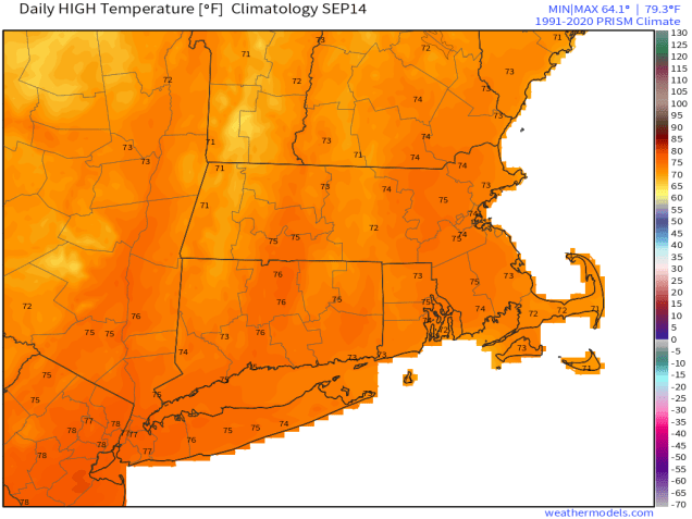
Average high temperatures for mid-September are in the lower to middle 70s. Image provided by Weathermodels.com

A weak cold front moves through this evening with little fanfare, then high pressure builds in with sunshine and cooler temperatures for Friday and Saturday. An upper-level disturbance moves through on Sunday with some showers likely, especially in the afternoon. Monday is a bit of a tricky forecast. Some models showed an upper-level low pressure area hanging around with more clouds and possibly some additional showers, but more recent trends have been for high pressure to build back in with drier weather.

The showers on Sunday will not make much of a difference for the ongoing drought. Images provided by Pivotal Weather.

Thursday night: Evening clouds, then becoming clear. Low 52-59.

Friday: Plenty of sunshine. High 67-74.

Friday night: Clear skies. Low 47-54.

Saturday: Morning sunshine with some afternoon clouds. High 70-77.

Saturday night: Partly cloudy. Low 52-59.

Sunday: Intervals of clouds and sun with some showers likely in the afternoon. High 71-78.

Sunday night: Any showers end in the evening, clearing overnight. Low 52-59.

Monday: Partly to mostly sunny. High 69-76.

Weekly Outlook: September 8-14, 2025

Much of the upcoming week will be dominated by quiet and cool weather thanks to a large high pressure area.

Temperatures will be several degrees below normal for much of the week. Image provided by WeatherBell.

The cold front that produced severe weather on Saturday and a cool but beneficial rainfall on Sunday has pushed offshore and high pressure will build in bringing drier air in along with temperatures that are below normal for today and Tuesday. Things could get a little complicated for part of the region for Wednesday. An area of low pressure will pass well offshore, but the precipitation shield around the edge of the system could get close to parts of the South Coast, possibly even a little farther northward. However, the high to the north looks like it may remain strong enough to keep most of the rain offshore, so we’re going to lean towards a dry forecast for now. High pressure returns for the end of the week and start of the weekend. A cold front will move through with little fanfare on Sunday, keeping us dry.

An offshore system may produce some rain across Cape Cod and the South Coast, or maybe it won’t. Images provided by Pivotal Weather.

Monday: Partly sunny. High 66-73.

Monday night: Clear to partly cloudy. Low 47-54.

Tuesday: Sunshine and some afternoon clouds, breezy near the coast. High 66-73.

Tuesday night: Partly to mostly cloudy. Low 49-56.

Wednesday: Intervals of clouds and sun, chance for a few showers near the South Coast and Cape Cod. High 65-72.

Wednesday night: Any showers end in the evening, becoming partly cloudy to clear. Low 50-57.

Thursday: Mostly sunny. High 73-80.

Thursday night: Clear skies. Low 50-57.

Friday: Sunshine and a few clouds. High 65-72.

Saturday: Mostly sunny. High 66-73.

Sunday: A mix of sun and clouds. High 68-75.

Weekly Outlook: September 1-7, 2025

Happy Labor Day and welcome to September. It marks the unofficial end of summer and the official start of meteorological autumn. College football is underway, the pros start this week, hockey training camps start up in a couple of weeks, pumpkin everything is available everywhere, and after a cool August, warmer weather will return for a few days this week.

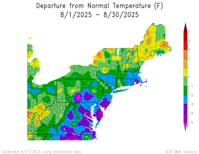
Temperatures were below normal across much of the Northeast during August. Image provided by the Northeast Regional Climate Center.

High pressure will keep us dry for the first half of the week, likely right into Thursday, but with an upper-level low nearby, we’ll still have some afternoon clouds each afternoon. Temperatures will be close to normal for early September to start the week, but as the high slides offshore, southwest winds will bring warmer and eventually more humid air in towards Wednesday and Thursday. A slow-moving cold front will move in Thursday night, with some showers and a few thunderstorms likely on Friday. With the front taking its time, Saturday may also be a warm and humid day, with the potential for some additional showers or thunderstorms, depending on when the front actually moves across the region. High pressure should build in behind the front for Sunday with cooler and drier weather, just in time for the Patriots home opener in Foxborough.

We’re not expecting a lot of rain with the cold front at the end of the week, but every little bit helps as the drought worsens. Images provided by Pivotal Weather.

Monday: Partly sunny. High 71-78, coolest along the coast.

Monday night: Partly cloudy with some patchy fog possible. Low 52-59.

Tuesday: Sunshine and some afternoon clouds. High 72-79, coolest along the coast.

Tuesday night: Clear to partly cloudy. Low 51-58.

Wednesday: A mix of sun and clouds. High 74-81, coolest along the coast.

Wednesday night: Clear to partly cloudy. Low 53-60.

Thursday: Partly to mostly sunny, breezy. High 75-82, coolest along the South Coast and Cape Cod.

Thursday night: Becoming cloudy, showers possible late at night. Low 57-64.

Friday: More clouds than sun with showers and a few thunderstorms likely, breezy, humid. High 73-80.

Saturday: Partly sunny, humid, a few additional showers or thunderstorm possible, breezy. High 75-82.

Sunday: Becoming partly to mostly sunny, drier. High 70-77.