We’ve got a very quiet weather pattern across the region for the next several days.
High pressure is providing us plenty of sunshine afternoon. Loop provided by the College of DuPage.
A chilly night is expected tonight with high pressure in control. Clear skies and light winds will allow for some radiational cooling, with some places dropping into the teens. Friday features sunshine, but a weak cold front will move through. It will have little moisture associated with it, so aside from a few snow showers in northern New England, you won’t really notice it. For Saturday, a storm system will pass well to the south, sending some clouds our way, but little else, as it will be too far south to have any other impacts. High pressure then returns for Sunday and Monday with dry and seasonably cool conditions.
Tranquil weather is expected through the weekend. Loop provided by WeatherBell.
Thursday night: Clear skies. Low 17-24.
Friday: Plenty of sunshine. High 33-40.
Friday night: Clear to partly cloudy. Low 18-25.
Saturday: A mix of sun and clouds. High 30-37.
Saturday night: Partly cloudy. Low 19-26.
Sunday: Partly sunny. High 31-38.
Sunday night: Partly cloudy. Low 16-23.
Monday: Sunshine and some afternoon clouds. High 33-40.
We’ve got a fairly quiet week coming up, but that doesn’t mean sunshine and mild weather the entire time.
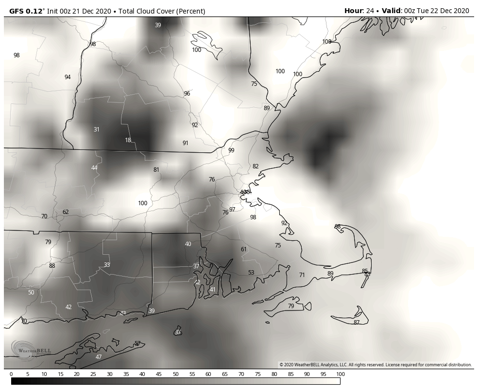
The storm system that brought us some rain and snow yesterday and last night will slowly pull away from the region today, but we’ll still have plenty of clouds, and maybe a few more showers, mainly across southeastern Massachusetts and Cape Cod. By Tuesday, the storm will stall out near Atlantic Canada, but the flow around it may help produce a few ocean-effect rain or snow showers, especially across eastern parts of the region. By Wednesday, the system pulls away and high pressure builds in with dry and seasonably cool conditions into Friday.
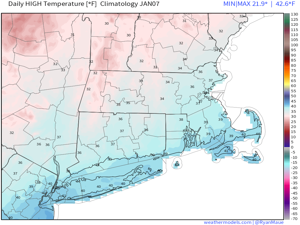
Normal high temperatures for early January are in the middle to upper 30s around here. Image provided by Weathermodels.com
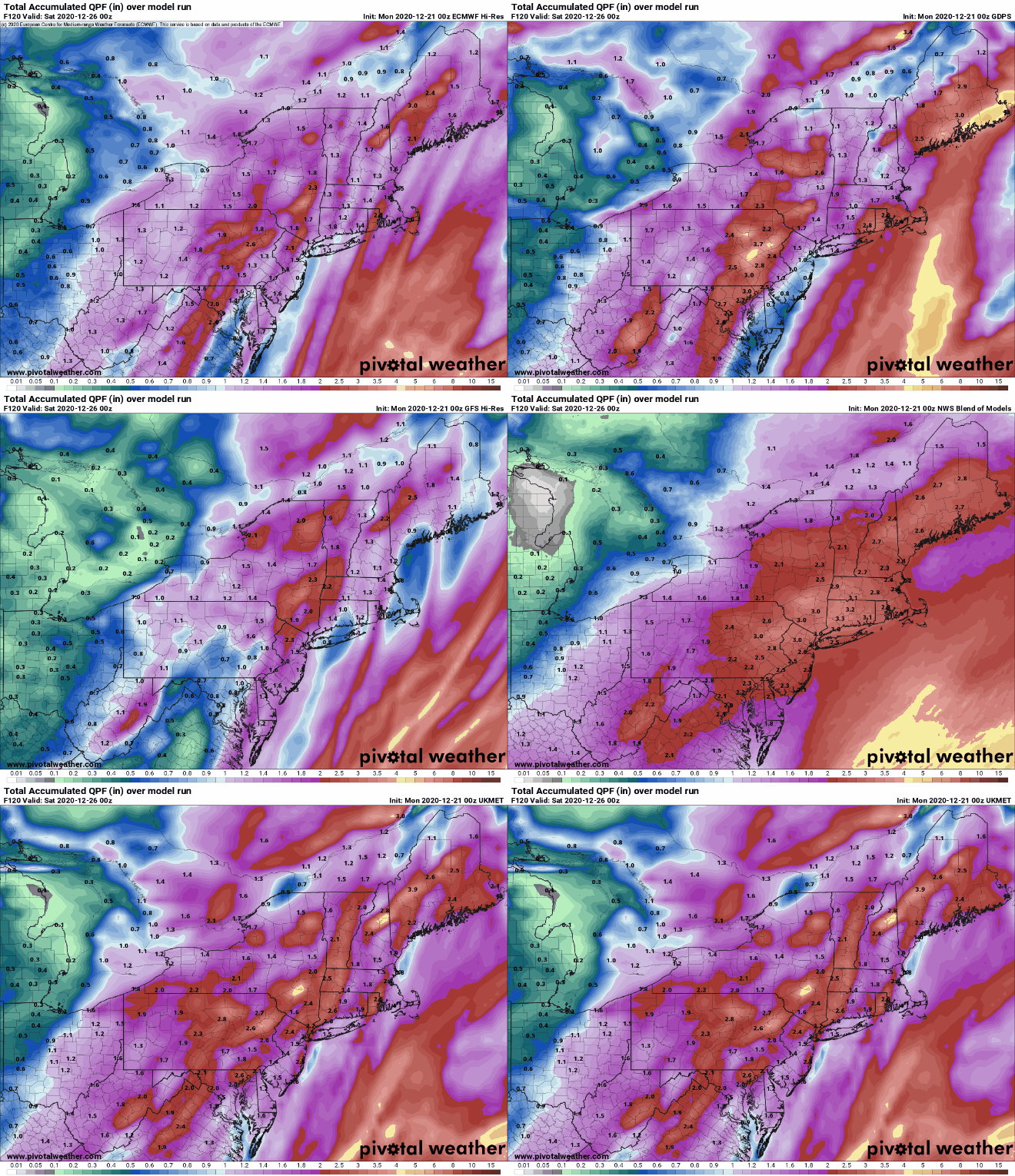
By Friday night, low pressure will be moving off the North Carolina coastline and headed off toward the northeast. Right now, it looks like this system will pass too far to the south and east to have any impact on us, except possibly Cape Cod and southeastern Massachusetts, but it’s still 5 days away and things can change, so we’ll keep an eye on it. Once that system pulls away on Saturday, high pressure builds back in for next weekend.
For now, the models are in agreement that a storm stays well to our south Friday night. Images provided by Pivotal Weather.
Monday: Plenty of clouds, some showers are possible across southeastern Massachusetts and Cape Cod, mainly in the morning, a few sunny breaks are possible well inland during the afternoon. High 35-42.
Monday night: Partly to mostly cloudy, a few rain or snow showers are possible in eastern areas. Low 24-31.
Tuesday: Mostly cloudy, chance for a few more rain or snow showers in eastern areas. High 32-39.
Tuesday night: Partly to mostly cloudy. Low 25-32.
Wednesday: Becoming partly to mostly sunny. High 33-40.
Thursday: Lots of sunshine. High 36-43.
Friday: Sunshine dimmed by increasing afternoon high clouds. High 33-40.
Saturday: Clouds early, skies start to clear out in the afternoon. High 31-38.
As we get into the final days of the year and start of a new year, we’ve got a fairly complex weather pattern shaping up across the region.
A warm front will move across the region tonight, but little precipitation will accompany it. What you will notice is that temperatures will bottom out this evening, then rise as we head through the overnight hours. Low pressure will move into the St. Lawrence Valley early on Thursday, dragging a cold front across the region during the morning. Some showers will accompany that front, but they’ll be gone by midday. High pressure then builds in, allowing skies to clear out in the evening. So, if you have any New Year’s Eve plans, weather won’t be an issue, though it will be on the cold side, as you’d expect at the end of December.
Temperatures should be in the middle to upper 20s under clear to partly cloudy skies at midnight Thursday night. Image provided by WeatherBell.
New Year’s Day starts off sunny and chilly, but clouds stream back in during the afternoon ahead of low pressure moving into the Great Lakes. We’ll see precipitation moving in towards midnight, but with cold air in place, things will be tricky. Along the coast, we’re looking at just a chilly rain, but across interior sections, it’ll be a different story. We’ll likely see it start off as snow, with some minor accumulations (an inch or two), especially from the Merrimack Valley and central Massachusetts into southern New Hampshire.
A little snow may accumulate early Saturday morning across the region, Image provided by WeatherBell.
Eventually, a change to sleet and freezing rain is expected across the interior as milder air moves in aloft. Milder air will also move in at the surface, so precipitation should change over to plain rain everywhere by Saturday morning, but before that happens, a period of freezing rain could result in some slippery travel across the interior before daybreak Saturday. The rain ends by midday, then we’ll see some clearing by late afternoon. This will also be short-lived.
The GFS model shows the progression of the Friday night storm. Loop provided by the College of DuPage.
Clouds come back in on Sunday as a storm system starts to move up the East Coast. There is still plenty of uncertainty with the track of this system, but a period snow or rain is looking likely for late Sunday into early Monday, especially across southeastern Massachusetts. We should have more clarity on this system once the Friday night system moves past the region.
There are discrepancies among the models in regards to our Sunday night storm. Images provided by Pivotal Weather.
Wednesday night: Cloudy and breezy with showers developing after midnight. Low 31-38 during the evening, temperatures rise overnight.
Thursday: Showers ending in the morning, some clearing develops late in the day. High 41-48.
New Year’s Eve: Becoming clear to partly cloudy. Low 19-26.
New Year’s Day: Sunny in the morning, clouds return in the afternoon. High 34-41.
Friday night: Cloudy with rain developing after midnight across the South Coast. Inland, snow will develop, changing to sleet, freezing rain, and eventually plain rain from south to north. Low 28-35 during the evening, temperatures rise overnight.
Saturday: Any remaining wintry mix across the interior changes to plain rain early, ending by midday. Some sunny breaks develop in the afternoon. High 35-42 north and west of I-495, 43-50 elsewhere.
Sunday night: Partly cloudy. Low 25-32.
Sunday: Cloudy with rain or snow possible late in the day. High 36-43.
Sunday night: Cloudy with a chance of rain or snow. Low 27-34.
Monday: Rain or snow ending in the morning, some clearing late in the day. High 35-42.
We’ve reached the final days of 2020, but there may still be a little mayhem on the horizon.
We start the week out on a rather mild note. Low pressure will head up the St. Lawrence Valley today, bringing in some clouds but also milder weather. There could be a shower or two, but the bulk of the precipitation associated with this storm will stay to our north and west. The storm drags a cold front across the region at night, putting an end to our brief mild spell. Breezy and colder conditions settle in for Tuesday as high pressure starts to build back in. Wednesday also looks to be on the cold side, but should be less windy, so it won’t feel as cold.
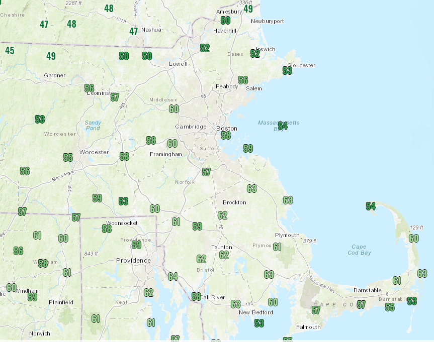
Temperatures could reach 50 in parts of the region this afternoon. Image provided by Weathermodels.com
This brings us to the final day of a year that most of us are all too happy to see end. Another low pressure area passes to our north and west, with milder conditions once again and some rain showers, though it does look like it should be dry for midnight if you are planning to be out and about. However, the cold front trailing that system will likely stall out near or just south of the region while high pressure tries to build in from the north early on New Year’s Day. Another low pressure area will start heading toward the Midwest that day as well. The front to our south will try to head back northward as a warm front, but with high pressure to the north, cold air may remain in place at the surface, especially across the interior. As the precipitation starts to move in, we may have warm air aloft and cold air at the surface, which would be a recipe for freezing rain. Obviously, being this far out, things will likely change, but we could be looking at icing, possibly some significant icing, across the interior. This system will take it’s time moving toward the region, so even though the warmer air should eventually win out and change everything to plain rain, the rain may continue into Saturday before winding down. High pressure builds in on Sunday with drier and cooler weather. We should have some additional clarity on this situation later this week in our Weekend Outlook, which may be published on Wednesday again.
The models don’t agree on what type of precipitation we’ll have on Friday, or whether we’ll have any at all. Images provided by Pivotal Weather.
Monday: Plenty of clouds, breezy, just a slight chance for a shower. High 43-50.
Monday night: Clearing. Low 24-31.
Tuesday: Sunny in the morning, some clouds around during the afternoon, breezy. High 29-36.
Tuesday night: Clear and chilly. Low 14-21, though some of the normally colder locations could drop into the single digits.
Wednesday: More clouds than sunshine. High 33-40.
New Year’s Eve: Cloudy and breezy with showers likely during the afternoon and evening. High 44-51.
New Year’s Day: Cloudy with a chance for rain near the coast, but a wintry mix of snow, sleet, or freezing rain is possible inland. Precipitation should gradually change to rain inland as we head through the overnight hours. High 38-45.
Saturday: Mostly cloudy with more showers possible. High 43-50.
We’ve got a couple of busy days coming up, and not just because it’s Christmas.
Low pressure is moving across Iowa this afternoon, producing blizzard conditions across parts of the Upper Midwest and Northern Plains. That system will impact us over the next few days, but in a different way. As it moves toward the Great Lakes, it will start to send milder air into the region tonight, but more noticeably tomorrow. Southerly winds will gradually increase tomorrow, becoming quite strong tomorrow night and into Christmas morning. Sustained winds of 15-30 mph are likely, with wind gusts to 50-60 mph or more possible. This could result in power outages, so don’t be surprised if you wake up Christmas morning and can’t charge up those new electronics you found under the tree.
Damaging wind gusts are possible across much of the region Thursday night and Christmas morning. Image provided by WeatherBell.
Wind isn’t the only issue we’ll have. Rain will move in Thursday night, and continue into Christmas Day. While it may not be raining the entire time, there will be some bands of heavy rain, with rainfall totals in excess of an inch possible in many areas. The rain, combined with temperatures climbing above 50, will help to melt a lot of the snow that is on the ground. This could result in some flooding issues in some spots, but widespread flooding doesn’t look likely.
The ECMWF shows how our snow cover could quickly disappear over the next few days. Loop provided by Weathermodels.com
As this storm system moves into southeastern Canada, it will drag a strong cold front across the region on Christmas Day. Although the day will start mild, likely in the 50s for most of us, temperatures will drop during the afternoon. If the cold air moves in fast enough and the precipitation is slower to move out, we could even see some wet snowflakes before everything winds down late in the day. At night, temperatures will continue to drop, meaning that the wet roads will likely start to ice over if they are not treated, as they won’t have had much time to dry before the cold air moves in.
The GFS model shows the warmer air move in on Christmas Eve, then quickly get replaced on Christmas Day. Loop provided by WeatherBell.
High pressure builds in for the weekend with dry and seasonably cold conditions. It may still be a bit breezy on Saturday, adding to the chill, but Sunday may also be a few degrees milder. By Monday, we’ll be watching another storm system passing to our west, with some showers possible.
Wednesday night: Becoming partly to mostly cloudy. Low 23-30 this evening, but temperatures may start to rise a bit after midnight.
Christmas Eve: Mostly cloudy, becoming breezy in the afternoon. High 48-55.
Thursday night: Cloudy and windy with showers developing, becoming steady rain late at night. Temperatures gradually rise overnight.
Christmas Day: Cloudy with rain likely, possibly heavy at times, windy in the morning. High 53-60 in the morning, temperatures drop during the afternoon.
Friday night: Mostly cloudy and breezy with any lingering showers ending in the evening, possibly mixed with a few wet snowflakes, some clearing is possible late at night. Low 22-29.
Saturday: Becoming partly to mostly sunny. High 28-35 (welcome back to December).
Saturday night: Clear skies. Low 19-26.
Sunday: Partly to mostly sunny. High 32-39.
Sunday night: Increasing clouds. Low 22-29.
Monday: Mostly cloudy and breezy with a few showers possible. High 42-49.
We’ve reached the last full week of the year, and also the winter solstice. Winter officially begins at 5:02am, so by the time most of you read this, astronomical winter will have begun. That doesn’t mean it will feel like winter every day this week.
If you’re heading out early this morning, use a little extra caution, as there may be some black ice, especially away from the coastline. If you’re down the Cape, there’s some rain around this morning, but it should be gone by midday as a low pressure area pulls away from the region. For the rest of us, today will just be a cloudy day, with temperatures fairly typical of late December. We may get a few breaks in the clouds this evening, which would allow you to view the conjunction between Saturn and Jupiter. Otherwise, it’ll remain mostly cloudy overnight and into Tuesday as another weak system moves through with a few rain or snow showers. Once that system moves through, we clear out for Wednesday as high pressure builds in, but it will be chilly.
Some breaks in the clouds this evening may allow you to view the Conjunction of Saturn and Jupiter. Image provided by WeatherBell.
This brings us to Christmas Eve. Low pressure will be heading into the Great Lakes, with milder air moving in ahead of it. Many of the forecast models are showing the potential for strong winds, heavy rainfall, and unseasonably warm temperatures for Christmas Eve into early on Christmas Day before a strong cold front moves across the region. Given the recent performance of the models this far in advance, plus some of the model trends we’ve already seen, we’re a bit skeptical. Yes, we expect it to be mild with some rain. However, we’re not yet convinced that temperatures will be in the upper 50s to lower 60s with 1-2 inches of rain (or more), like many of the models are showing. The system will drag a strong cold front through on Christmas morning, with temperatures dropping quickly on Christmas Day. Now, it won’t be anything like Christmas Day in 1980, but it will be enough for any untreated surfaces to ice up, and possibly for some snow showers. We’ll obviously have a better idea about this system in our Weekend Outlook, which will likely be published on Wednesday this week.
Most of the models are showing the potential for 1-2 inches of rain (or more) Christmas Eve into Christmas Day. Images provided by Pivotal Weather.
(For those wondering, the temperature in Boston on Christmas Day, 1980 was 35 degrees at midnight. A strong cold front moved through just after midnight, and the temperature dropped to -7 by 10am, and only got back up to -2 in the afternoon. Add in the northwest winds of 10-20 mph all day long and it was a brutally cold day.)
Behind that system, high pressure will build in next weekend with drier and colder weather, which is pretty much what you’d expect in late December. There are some indications that our active pattern may continue into next week with more storminess possible.
Monday: Showers end across Cape Cod in the morning, otherwise, plenty of clouds with a few sunny breaks High 35-42.
Monday night: Partly to mostly cloudy. Low 23-30.
Tuesday: Intervals of clouds and sunshine with a rain or snow shower possible. High 35-42.
Tuesday night: Clear to partly cloudy. Low 21-28.
Wednesday: Sunshine fades behind increasing late-day clouds. High 33-40.
Christmas Eve: Cloudy and breezy with showers possible late in the day, and a period of steady rain likely at night. High 43-50.
Christmas Day: Rain may change to snow before ending around midday. High 45-52 early, then temperatures quickly drop in the afternoon.
After several days of media hype, and people posting model forecasts for extreme amounts of snow on social media, it looks like we do actually have a snowstorm on the way, and it could be a decent-sized one for parts of the region.
High pressure over Ontario and low pressure over Texas are two things we need to pay attention to for the next day or two. Image provided by NOAA.
Low pressure over Texas this afternoon will combine with a second area near the Texas coast to become a single storm system later today, which will then head northeastward into the Tennessee Valley tonight, bringing plenty of moisture with it from the Gulf of Mexico. Meanwhile, a strong high pressure system is moving across southeastern Canada, bringing plenty of cold air into the Northeast. When you get copious amounts of moisture running into cold air, you end up with snow, potentially a lot of it,. That’s what’s going to happen here late Wednesday into Thursday.
Winter Storm Watches are in effect for all of Southern New England. Image provided by Pivotal Weather.
That low pressure area will move from the Tennessee Valley to the Mid-Atlantic coastline on Wednesday before moving offshore and passing south of New England. While there are still some questions as to the exact track it will take, which has implications for the forecast itself, the models have come into better agreement today on a more northerly track than they were showing last night. This has several implications for the forecast around here:
1. Snow will likely penetrate even farther inland, with heavier snow farther inland as well. 2. Rain/snow ratios will be lower across southeastern New England, resulting in a wetter snow. 3. A change to sleet or rain is now possible across Cape Cod, and possibly parts of southeastern Massachusetts and southern Rhode Island.
We mentioned in our Weekly Outlook that there would likely be a sharp cutoff in the northern extent of the snow, going from heavy snow to little snow in a short span, but we weren’t sure where that cutoff would set up. At this point, it’s looking more and more likely that it will set up somewhere in central or southern New Hampshire, meaning that most of us will be shoveling by Thursday morning. This detail is still not definite, so obviously things can change in the next 24 hours or so.
Plenty of cold air will be in place before the storm moves in. Image provided by Weathermodels.com
That high pressure area in southeastern Canada will provide us with plenty of cold air, which will be evident tonight when temperatures drop into the teens or even single numbers. As the snow moves in Wednesday night, we’ll see a coastal front setup across eastern Massachusetts and Rhode Island. This is a common occurrence in winter storms. Basically, the northeast to east winds off the water send temperatures up to the lower to middle 30s along the coast and a short distance inland (anywhere from 20-40 miles). On the other side of that front, northeast to north winds keep the colder air locked in, with temperatures in the teens and lower 20s. Obviously, in the “milder” air on one side, you’ll get a wetter snow, with the possibility of some mixed precipitation, while the colder area gets mostly snow that is more powdery. We said “mostly snow”, as you can get some milder air aloft which could allow for some sleet to mix in, which obviously would have a significant impact on snow accumulations. That coastal front will eventually collapse southeastward toward the coast as the low pressure area moves by, allowing the colder air to eventually move back in everywhere, and any mixing that does take place eventually goes back over to all snow.
The snow to rain ratio varies by temperature, as this chart shows. Image provided by Weathertrends360.com
As for the timing, most of Wednesday should be fine, so you can do any errands that need to be completed before the storm moves in. Snow should move into the South Coast towards the evening rush, quickly spreading northward, reaching the MA/NH border by midnight. Snow may fall moderate to heavy at times overnight, with some mixing possible across Cape Cod and the Islands (and possibly southeastern Massachusetts) late at night and early Thursday morning. Most of the steady precipitation should wind down by midday, but some lingering snow showers are possible, especially along the coast, through the afternoon.
Snow isn’t the only threat with this system, as gusty winds are also expected, especially along the coastline. While this storm won’t be that strong, at least compared to many winter storms in the past, the gradient between it and the large high pressure area to the north will create some gusty winds. Sustained winds of 15-25 mph, with gusts to 40 mph or more, are likely. These gusty winds may enhance the snow across parts of eastern Massachusetts. However, with high astronomical tides, the winds may also result in some coastal flooding around high tide, especially at northeast and east facing coastal areas.
Wind gusts to 40 mph or more are possible, especially along the coast. Image provided by WeatherBell.
So, how much snow are we looking at? Obviously, there’s still some things that complicate this part of the forecast (snow ratios/mixing/northern extent of the snow), so this is preliminary for now, and we may adjust it tomorrow if needed, but here’s our thinking:
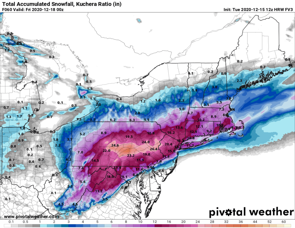
Central New Hampshire: 2-4″ Southern New Hampshire/Seacoast: 4-8″ Merrimack Valley/Central Massachusetts: 5-10″ North Shore/MetroWest/Metro Boston: 6-12″ Interior Southeastern Massachusetts/Rhode Island: 8-14″ Cape Cod and the Islands: 4-8″
This model is probably closest to our thinking on snow accumulations at the moment. Image provided by Pivotal Weather.
Colder air will settle back into the region behind the storm for Thursday night and Friday, so you’ll want to clear out the driveways and walkways before everything freezes solid.
Hope you enjoyed the 60-degree temperatures on Sunday, because changes are coming. It’s going to snow this week, likely more than once for many of us.
Sunday was a mild day across most of the region. Image provided by NOAA.
A cold front moved across the region overnight and is now south of us. Low pressure will move off the Mid-Atlantic coastline and ride along that frontal system today. Precipitation will move in towards midday and continue through the afternoon, ending in the evening. Temperatures will be near or above freezing, so we’ll see a mix of rain and snow, likely changing over to snow before ending in many areas as colder air filters in behind the system. We’re not expecting much accumulation, mainly an inch or so, and mainly south of the Mass Pike. A few places could see up to 2 inches in heavier bursts, but overall this isn’t a big deal. However, since it will fall during the afternoon, it could make a mess of the afternoon commute, so keep that in mind if you are not working from home. North of the Mass Pike, we’re only looking at some flurries, if that, with the ground getting coated in some locations.
Not much snow is expected today, but the timing will make it a bit more impactful. Image provided by WeatherBell.
That storm will move into Atlantic Canada on Tuesday, and strengthen into a powerful storm system. Gusty northwest winds behind the storm will usher much cooler air in for Tuesday and Wednesday as high pressure moves into southeastern Canada. This will become important as we head into later Wednesday and Thursday as the next storm system moves towards the area.
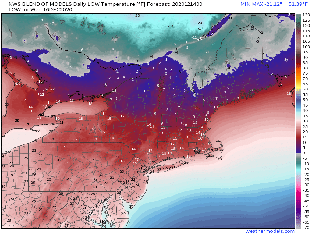
Wednesday morning could be rather chilly across the region. Image provided by Weathermodels.com
As you’ve no doubt heard by now, a rather strong storm system will impact the East Coast later Wednesday into Thursday. With high pressure to the north, we’ll have plenty of cold air in place, so anything that does fall will almost certainly fall in the form of snow. As the storm strengthens, it will produce gusty winds in some areas, which combined with the high astronomical tides, could result in some coastal flooding, especially east and northeast-facing locations. Beyond that, there’s a lot of uncertainty. That storm that moved into Atlantic Canada will not move too much, and it will have an impact on the track our mid-week storm takes. Another factor will be the high pressure area to our north. It will try to send cool and dry air southward into the region. This will likely result in a sharp cutoff of the precipitation, going from heavy snow to virtually no snow over a relatively small area. Where that cutoff sets up is also still in question. The models, while in general agreement that a powerful storm will move off the Atlantic Coast and south of New England, differ on some of the finer details, which have an enormous impact on the forecast. It’s still WAY too early to pin down any specifics, so we won’t bother to attempt it. We’ll just say that the potential exists for a significant snowstorm across the region from late Wednesday into Thursday. Beyond that, we’ll offer more details in a special blog post on Tuesday.
Differences among the models can have a big impact on the forecast for the storm around here. Images provided by Pivotal Weather.
Behind the storm, high pressure builds back in for Friday and Saturday with dry and chilly conditions. If there’s fresh snow on the ground, some places could get quite chilly at night, especially Thursday night and Friday night. By Sunday, the high moves offshore and temperatures will start to moderate. However, another system may bring in some rain or snow. We’ll worry about that one after we get through the first two.
Monday: Cloudy with rain or mixed precipitation developing around midday, eventually changing to light snow by late afternoon. High 32-39.
Monday night: Light snow ends in the evening, then skies clear out overnight. Low 23-30.
Tuesday: Sunshine and some afternoon clouds, breezy. High 28-35.
Tuesday night: Clear during the evening, clouds move in late at night. Low 12-19.
Wednesday: Cloudy and becoming breezy with snow possible late in the day and at night. High 24-31.
Thursday: Cloudy and windy with snow likely, ending during the afternoon. High 24-31.
Friday: Partly to mostly sunny. High 27-34.
Saturday: Sunny in the morning, clouds return in the afternoon. High 30-37.
Sunday: Cloudy with a chance of rain or snow. High 37-44.
Another stormy weekend is on tap, but it shouldn’t be anywhere near as bad as last weekend was.
High pressure will remain in control of the region into Friday, with generally dry weather and moderating temperatures. However, low pressure will be heading towards the Great Lakes, sending cloudcover our way, though Friday will still be a decent day around here, by mid-December standards at least.
We still need more rain to alleviate drought conditions, and this weekend will help. Image provided by the National Drought Mitigation Center.
By Saturday, that low will be moving across the Midwest, resulting in a few things happening around here. Some rain will move in late in the day and at night, likely ending Sunday morning. While it’s not expected to be heavy, it will make for a wet Saturday night and Sunday morning. The storm will also send a warm front toward the region, but this is where things get tricky, because we’ll also have a strong high pressure area in southeastern Canada. That high will send cooler air down into the region – meteorologists refer to this as “cold air damming”, as both the mountains to the west and the warm front to the south act as a dam to prevent the cold air from advancing. That warm front likely doesn’t get much past the Mass Pike Saturday night, which keeps areas north of the Pike on the cool side. Meanwhile, a wave of low pressure will ride along that front, keeping the cold air locked in from southern New Hampshire into the Merrimack Valley. Temperatures will likely be in the middle to upper 30s in these areas, but if they are just a few degrees cooler, then we may have to worry about the rain becoming freezing rain. If you’ve got plans in these areas Saturday night, keep an eye on the conditions before you head out.
Most of the models show the warm air staying south of the Mass Pike Saturday evening. Images provided by Pivotal Weather.
By Sunday, the main low pressure area moves into southeastern Canada, dragging a frontal system across the region. As winds shift into the west, it will scour the cold air out, bringing milder air in. For areas south of the Mass Pike, where the warm air will already be in place, temperatures will actually cool off a bit behind the front on Sunday. High pressure returns on Monday with cooler air drier conditions.
Finally, we’ll just address this now, before the hype gets out of control. Yes, there are some models that show the potential for a snowstorm towards the middle to latter half of next week. However, not all of the models show that. Plus, most of the models have done a relatively poor job forecast beyond about 3-4 days out for quite a while now. So yes, there is the “potential” for something next week. There’s also the “potential” that the Patriots will win the Super Bowl again this season. That’s all it is for now – potential. We’ll address it in a bit more detail in out Weekly Outlook Monday morning, if the potential is still there.
Thursday night: Clear to partly cloudy. Low 21-28.
Friday: Sunshine dimmed by afternoon high clouds. High 45-52.
Friday night: Thickening clouds. Low 27-34 north of the Mass Pike, 35-42 south of the Pike.
Saturday: Cloudy with showers developing by late afternoon. High 41-48 north of the Mass Pike, 49-56 south of the Pike.
Saturday night: Scattered showers, possibly some freezing rain across parts of southern New Hampshire. Low 32-39 north of the Mass Pike, 40-47 south of the Pike.
Sunday: Any lingering showers end in the morning, some afternoon sunny breaks are possible. High 47-54.
We’ve got a fairly quiet week coming up across the region with a moderating trend as well.
We start the week off with high pressure in control, providing us with dry and cool conditions. We’ll start off sunny, but high clouds will start to stream in during the afternoon ahead of low pressure moving off the Carolina coast. That system will pass well to our south and east on Tuesday, but the flow around it, moving over the still relatively mild ocean, could help generate a few ocean-effect rain or snow showers, mainly across Cape Cod and east-coastal Massachusetts, especially coastal Plymouth County and Cape Ann. That system pulls away Tuesday night, but another weak upper-level disturbance swings through on Wednesday. Moisture will be limited with this system, but again, a few rain or snow showers can’t be ruled out, mainly well north and west of Boston. High pressure builds in again for Thursday and Friday with generally dry weather and moderating temperatures.
Temperatures should start to moderate by Thursday. Image provided by Weathermodels.com
Things start to get active again next weekend. Most of the models show a low pressure area heading into the Great Lakes and then southeastern Canada. This would result in a warmup around here with some rain likely as the storm drags a frontal system toward the region. However, most of these same models showed a similar scenario for the storm we just had on Saturday. Also, some of the members of the various ensembles show the potential for a secondary area of low pressure to develop south of New England, a common occurrence with low pressure areas that pass well to our west. If this were to happen, it would result in the warm air never making it in here. Now, this doesn’t mean we’ll be in for another snowstorm. It also doesn’t mean that we won’t get well into the 50s with more rain. Obviously, things can and will change as we head through the week. Consider our forecast for next weekend to be “low confidence” right now.
Several members of the GFS Ensemble show a secondary area of low pressure near or south of Southern New England next Sunday. Image provided by WeatherBell.
Monday: Sunshine fades behind thickening afternoon clouds. High 32-39.
Monday night: Partly to mostly cloudy, a few flurries may develop late at night near the east coast. Low 19-26.
Tuesday: More clouds than sun, a few rain or snow showers possible near the coast. High 29-36.
Tuesday night: Partly to mostly cloudy. Low 17-24.
Wednesday: Mostly cloudy, slight chance for a rain or snow shower, favoring areas north and west of Boston. High 34-41.
Thursday: Plenty of sunshine. High 40-47.
Friday: Sunshine dimmed by some afternoon high clouds. High 40-40.
Saturday: Plenty of clouds with showers possible, mainly late in the day and at night. High 47-54.
Sunday: Cloudy with a chance for more showers, mainly early. High 49-56.