Weekend Outlook: August 10-13, 2023

An active weather pattern is expected for the next few days with several chances of rain.

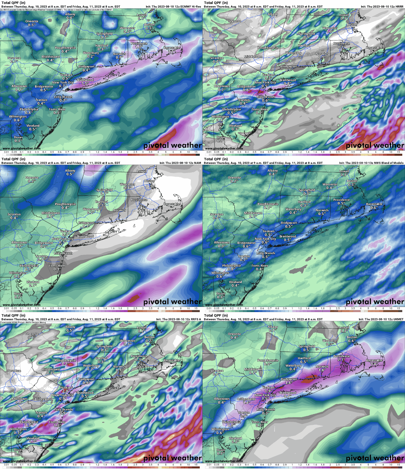
A low pressure system will move across the region this evening, with some showers and thunderstorms likely. A few of the storms could produce some heavy rain, and there is a very low risk for some severe storms, mainly near the South Coast. We could see some brief spinups that may result in a weak tornado, similar to what we saw on Tuesday.

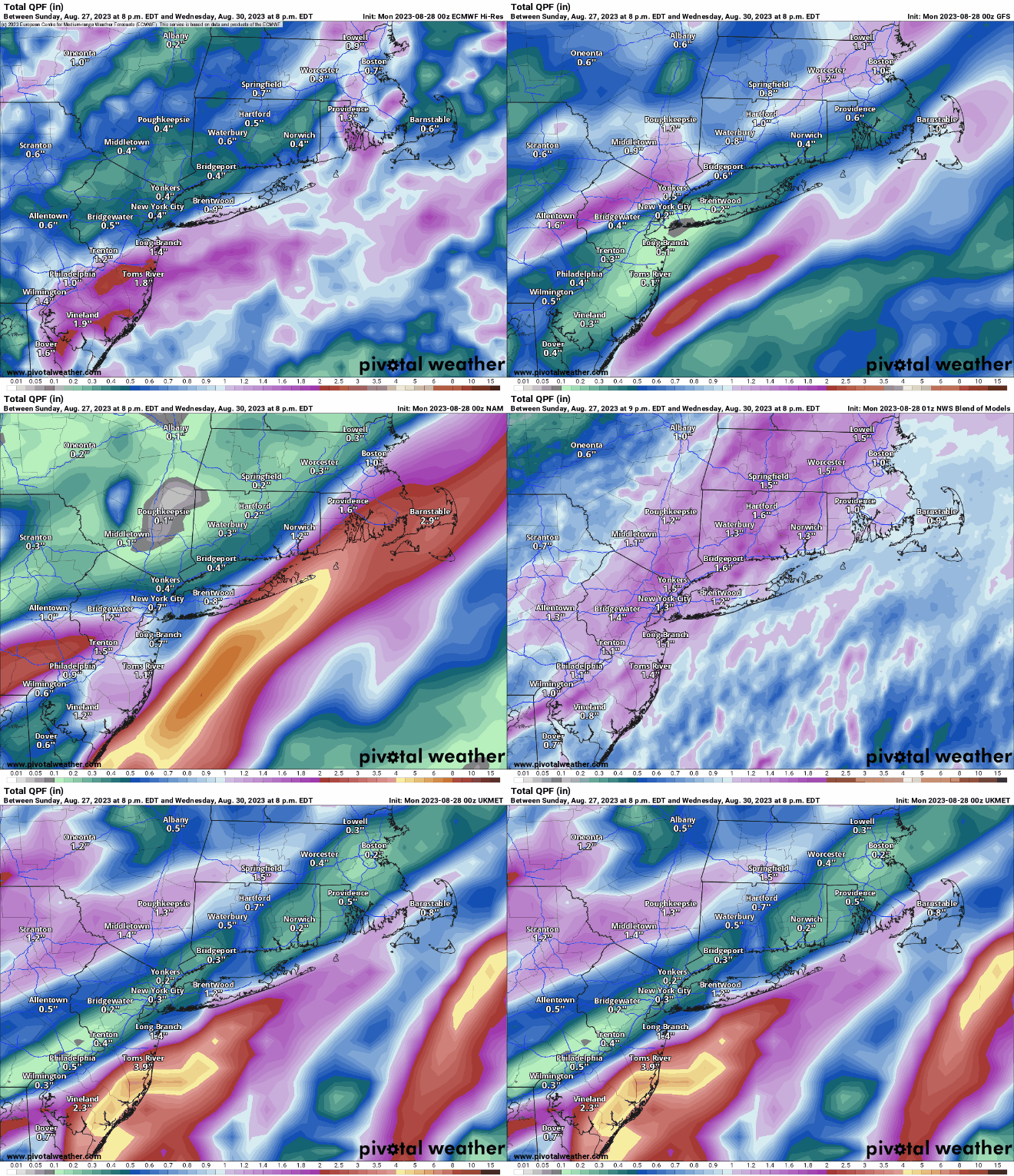
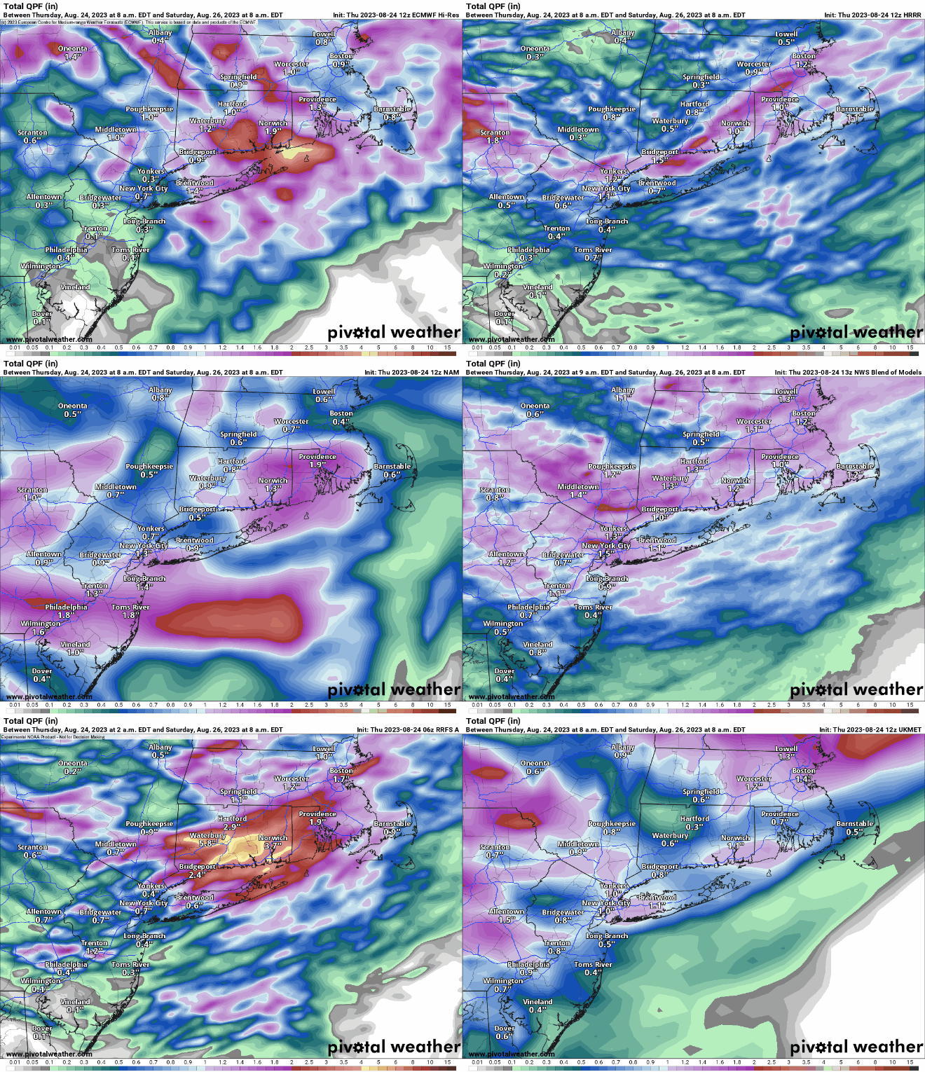
A few models show the potential for some heavy rain tonight, especially near the South Coast. Images provide by Pivotal Weather.

The rain winds down around midnight, then skies clear out as high pressure builds in, setting up a fantastic Friday with sunshine, seasonably warm temperatures, and low humidity. Clouds stream back in on Saturday ahead of the next system. This one will be moving along quickly, but it will likely bring in some showers and thunderstorms Saturday night into Sunday morning. We’ll clear out behind that system Sunday afternoon, but another one quickly follows for Monday. Most of Monday should remain dry, but showers and thunderstorms may develop late in the day. They’ll be more likely at night and into Tuesday, with some heavy rain possible once again.

Dewpoints will drop into the 50s for most of the region Friday afternoon. Images provided by WeatherBell.

Thursday night: Showers and thunderstorms likely this evening, skies start to clear out after midnight. Low 60-67.

Friday: Sunshine and a few afternoon clouds, breezy. High 76-83.

Friday night: Clear skies. Low 56-63.

Saturday: Morning sun, increasing afternoon clouds. High 79-86.

Saturday night: Partly to mostly cloudy with some showers and thunderstorms likely. Low 64-71.

Sunday: Showers end early, clearing during the afternoon, breezy. High 79-86.

Sunday night: Clear to partly cloudy. Low 58-65.

Monday: Sunny in the morning, clouds return in the afternoon with a chance for showers and thunderstorms late in the day. High 77-84.

Weekly Outlook: August 7-13, 2023

“Everything in moderation, including moderation” – Oscar Wilde

Mother Nature is taking that quote to heart this week, as we’ll have moderately high temperatures at times, moderate humidity at times, and some moderate rain at times.

Dewpoints will jump into the 70s across the region on Tuesday. Images provided by WeatherBell.

A low pressure system will move across the Ohio Valley, passing north and west of the region over the next day or two. Some showers will develop ahead of the system today as it sends a warm front in, with a very noticeable spike in the humidity. The showers will be mostly on the light side, and not everyone will get them. We’ll have a bit of a lull in the activity during the afternoon, then an area of steadier rain will likely move in by evening, and continue overnight into Tuesday morning. We could be looking at a second round of showers and thunderstorms later in the day as the cold front trailing the low pressure system finally moves through and pushes offshore. Wednesday looks like the pick of the week, with high pressure building in, providing sunshine, warm temperatures and lower humidity. The latter half of the week and the weekend look unsettled at this time, with a series of disturbances moving through. These will generate showers and thunderstorms at times, but the timing of these disturbances is still in question. None of the days will be a washout, but if you’ve got outdoor plans, keep an eye on updated forecasts as the week goes on.

A few models show the potential for some heavy downpours tonight across the region, but most of the models do not. Images provided by Pivotal Weather.

Monday: Plenty of clouds with a few breaks of sunshine, some showers around, especially during the morning and early afternoon. High 72-79.

Monday night: Mostly cloudy and breezy with some showers and thunderstorms likely. Low 63-70.

Tuesday: Cloudy with showers and thunderstorms during the morning, some clearing in the afternoon, then another round of showers and thunderstorms possible late in the day. High 76-83.

Tuesday night: Becoming partly cloudy, breezy. Low 61-68.

Wednesday: Plenty of sunshine, still breezy, but not as humid. High 77-84.

Thursday: Morning sun, then clouds start to move back in, a few showers possible late in the day. High 79-86.

Friday: A mix of sun and clouds. High 79-86.

Saturday: Partly sunny with some late-day showers and thunderstorms possible. High 79-86.

Sunday: Partly sunny. High 78-85.

Weekend Outlook: August 4-7, 2023

Humidity and rain are set to return to the region, but they won’t hang around that long.

Dewpoints will jump back into the middle to upper 60s on Friday. Images provided by Weathermodels.com

A warm front will move toward the region tonight, bringing the humid air back in. A few showers may accompany the front, but most of the region should remain dry. As low pressure moves into southeastern Canada, it will drag a cold front our way. A few days ago, it looked like another washout with heavy rain, especially late in the day, but now, it looks like some occasional showers, especially during the morning/early afternoon, then again at night as the front finally moves through. Some of the storms could still produce some heavy rainfall, but we’re not looking at another widespread heavy rain/flooding event. We’ll clear out for Saturday as high pressure builds in, and it will remain in control for Sunday. though we may see a little more in the way of cloudcover on Sunday. The next frontal system approaches on Monday with increasing clouds, though most of the rain should hold off until evening.

A few models still show the potential for some heavy rain tomorrow, but overall, it shouldn’t be that bad. Images provided by Pivotal Weather.

Thursday night: Becoming partly to mostly cloudy, chance for a shower or two. Low 60-67.

Friday: Plenty of clouds, some showers likely, especially during the morning and early afternoon High 72-79.

Friday night: Showers ending, skies start to clear out late at night. Low 59-66.

Saturday: Sunshine and a few clouds. High 76-83.

Saturday night: Clear to partly cloudy. Low 57-64.

Sunday: A mix of sun and clouds. High 77-84.

Sunday night: Partly cloudy. Low 58-65.

Monday: Partly sunny, clouds thicken up late in the day, showers may develop by evening. High 78-85.

Weekly Outlook: July 31-August 6, 2023

After one of the wettest Julys on record, we’ve got an extended stretch of dry weather to start August.

It has been an extraordinarily wet July across the Northeast. Images provided by WeatherBell.

A weak cold front will cross the region today, generating some clouds and possibly a few showers this afternoon, otherwise, high pressure will be in control through Thursday, with sunshine, cool temperatures and, lower humidity levels. Yes, you can turn off the air conditioning and open the windows for the next several days and save on that electric bill. By the end of the week, another upper-level low will drop into the Great Lakes, while at the surface, a low pressure area moves into southeastern Canada, dragging a cold front across the region. The result will be some showers and thunderstorms on Friday and early Saturday, with some heavy rain possible. High pressure builds back in for later Saturday and Sunday with drier weather.

Some of the models show the potential for some heavy rain around here Friday into Saturday. Images provide by Pivotal Weather.

Monday: Morning sun with some afternoon clouds and a few showers or thunderstorms. High 75-82.

Monday night: Clear skies. Low 55-62.

Tuesday: Sunshine with some afternoon clouds again. High 73-80.

Tuesday night: Clear skies. Low 52-59.

Wednesday: Plenty of sunshine. High 72-79.

Thursday: A mix of sun and clouds, breezy. High 75-82.

Friday: Partly to mostly cloudy and breezy with showers and thunderstorms developing. High 74-81.

Saturday: Showers end early, becoming partly sunny. High 75-82.

Sunday: A mix of sun and clouds. High 77-84.

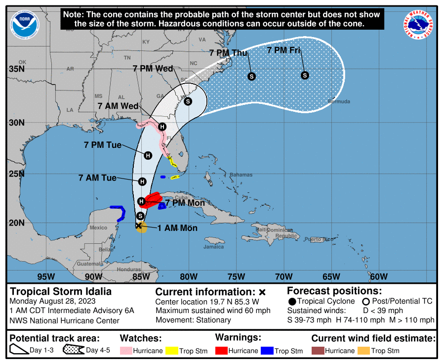
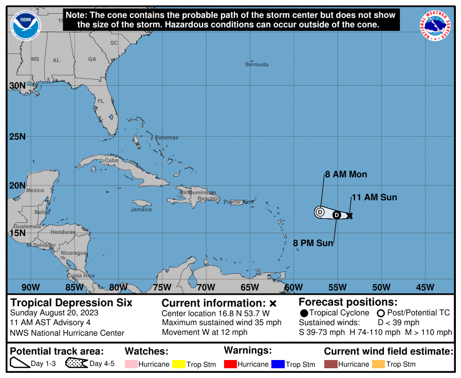
After a bit of a lull, we may have some activity in the Atlantic over the next couple of days. Images provided by the National Hurricane Center.

Finally, a quick note on the tropics. The potential exists for two named tropical systems to develop in the Atlantic over the next 24-48 hours, but neither of them will be a threat to any land areas. A tropical wave and associated area of low pressure has been slowly organizing as it made its way across the Atlantic over the past week. Conditions are favorite for some additional development as the storm turns toward the north well east of the Lesser Antilles today. It should head northward and then eventually northeastward, likely become a tropical depression and quite possibly a tropical storm over the next couple of days. It could eventually become a potent extratropical system as it heads toward the British Isles at the end of the week. There’s also a system off the North Carolina coast. This system produced heavy rain across parts of Florida and the Southeast over the past few days, and now that it is offshore again and over the warm waters of the Gulf Stream, it has a small window where it could become a tropical depression or tropical storm today before it merges with a frontal system and races northeastward over the open waters of the Atlantic. If either system does develop, we’ll have another post on Monday talking about the tropics around the world, as the Atlantic isn’t the only place with tropical activity at the moment.

Weekend Outlook: July 28-31, 2023

We’ve got a little bit of everything this weekend – severe weather, heat and humidity, and a return to cooler and drier weather. Let’s get right to the details.

A severe thunderstorm watch is in effect until 8pm. Image provided by NOAA.

We’re starting things off on an active note, with a severe thunderstorm watch in effect for most of the region, except Cape Cod and the Islands, until 8pm. A vigorous upper-level disturbance is moving toward the region, and it has already triggered some showers and thunderstorms. They’ll become a bit more widespread as the afternoon wears on while moving generally eastward towards the area. Some of the stronger storms may produce hail, strong winds, heavy downpours that could lead to flash flooding, and possibly a tornado or two. With the potential for some heavy rain, a Flood Watch is also in effect for a good portion of the area. Activity should wind down and move offshore before midnight, leaving us with a warm and muggy night, with many spots not dropping below 70. Friday looks to be a very warm to hot day with moderate to high humidity for much of the region. High temperatures will likely approach or exceed 90 in many locations, except for the immediate South Coast. The combination of heat and humidity will send the heat index well into the 90s, so a Heat Advisory has also been issued. Friday night will be another warm and muggy night, leading into Saturday, which is the transition day.

The heat index will be in the middle to upper 90s in many areas Friday afternoon. Images provided by WeatherBell.

Saturday will start off with some sunshine, along with very warm and humid conditions, but a strong cold front will be moving toward the region. Depending on how quickly the clouds move in, some spots could reach 90 by midday, especially south of the Mass Pike. We’ll have some showers and thunderstorms developing ahead of the front by early afternoon, and again, the threat is there for some severe weather, as well as heavy rainfall, so Flood Watches will likely be issued once again. Showers and storms end with the passage of the cold front at night, then a much cooler and drier airmass settles in for Sunday and Monday. Dewpoints will drop into the 50s, and temperatures will only be in the upper 70s and lower 80s for highs both days. With night time lows dropping into the 50s in many spots Sunday night, you’ll be able to turn off the air conditioner and open the windows in your dwelling. This airmass may hang around for a good chunk of the week, with one model showing the potential for a few spots to drop into the upper 40s Wednesday morning. We’ll have a closer look at that in our Weekly Outlook early Monday morning.

Lows could drop into the 50s in many locations Monday morning. Image provided by Weathermodels.com

Thursday night: Showers and thunderstorms, some strong to severe during the evening, ending by midnight, then skies clear out. Low 67-74.

Friday: Sunny, hot, and fairly humid. High 86-93.

Friday night: Clear skies, clouds start to filter in late at night. Low 68-75.

Saturday: Some morning sun, then becoming mostly cloudy with showers and thunderstorms developing by early afternoon, some could be strong. High 84-91.

Saturday night: Showers and thunderstorms end during the evening, some clearing late at night. Low 60-67.

Sunday: A mix of sun and clouds. High 74-81.

Sunday night: Clear to partly cloudy. Low 56-63.

Monday: Sunshine and a few clouds. High 75-82.

Weekly Outlook: July 24-30, 2023

It’s been a very wet July across most of the region, but this week will be drier, but also warmer.

Temperatures have been 2-4 degrees above normal across the Northeast this month and even warmer weather is expected this week. Image provided by the Northeast Regional Climate Center.

We start the week off with high pressure keeping the region dry and warm, but a weak upper-level trough of low pressure remains in place across the southeastern Canada. As little disturbances rotate around that trough, we may see a few showers and thunderstorms pop up each afternoon, but they’ll be widely scattered, and mainly across the interior. For most of us, it’ll just be partly to mostly sunny, quite warm, and not that humid for Monday and Tuesday. During the latter half of the week, both temperatures and humidity levels will be on the rise, with a couple of hot days expected for Thursday and Friday. Beyond that, a cold front will be dropping down from Canada, producing some showers and thunderstorms late Friday into early Saturday. The question is, when does the front actually move through? That’ll be the difference between another hot and humid day on Saturday or a cooler and drier day. By Sunday, the cooler and drier air should finally settle into most of the region.

Saturday could be either warm or hot, depending on which model you trust. Images provided by Pivotal Weather.

Monday: Sunshine filtered through some high clouds, slight chance for an afternoon shower or thunderstorm, mainly well north and west of Boston. High 82-89.

Monday night: Clear to partly cloudy. Low 64-71.

Tuesday: A mix of sun and clouds, a few showers and thunderstorms develop in the afternoon. High 81-88.

Tuesday night: Partly cloudy. Low 63-70.

Wednesday: Mostly sunny, just a very slight chance for an afternoon shower or thunderstorm. High 84-91.

Thursday: A mix of sun and clouds, a few showers and thunderstorms possible during the afternoon and evening. High 87-94.

Friday: Partly sunny, some showers and thunderstorms possible at night. High 88-95.

Saturday: Intervals of clouds and sun, chance for a few showers and thunderstorms, mainly early. High 82-82.

Sunday: Partly to mostly sunny. High 75-82.

Weekend Outlook: July 21-24, 2023

We’ve actually got some nice weather coming up for the weekend, unlike the last several weekends across the region.

Most of the region has received between 5 and 12 inches of rain over the past 30 days. Image provided by WeatherBell.

A warm front will move toward the region tonight, spreading in some clouds, and possibly a shower or two. A cold front will move toward the region on Friday, with plenty of clouds, and some showers and thunderstorms, though it looks like they may hold off until late in the day, more likely during the evening and at night. The front pushes offshore early Saturday, with skies gradually clearing during the day. Temperatures will remain on the warm side, but as high pressure settles in, humidity levels will drop. The high then remains in control for Sunday and Monday with sunshine, warm temperatures, and moderate humidity levels.

Dewpoints in the 50s Sunday afternoon? A much-welcome change from the past couple of weeks. Images provided by Weathermodels.com

Thursday night: Partly cloudy this evening, then clouds move in overnight, just a slight chance for a shower. Low 61-68.

Friday: Plenty of clouds with showers likely thunderstorms developing late in the day. High 75-82, coolest along the coast.

Friday night: Showers and storms taper off in the evening, some late-night clearing. Low 61-68.

Saturday: Gradual clearing. High 78-85.

Saturday night: Clear skies. Low 60-67.

Sunday: Lots of sunshine. High 80-87.

Sunday night: Clear to partly cloudy. Low 61-68.

Monday: A mix of sun and clouds. High 81-88.

Weekly Outlook: July 17-23, 2024

Yup, we’re still stuck in the same pattern we’ve been in for a while now, with an upper-level low sitting near the Great Lakes. Some days will be like yesterday – wet (or very wet), and some will be like today (dry), but there’s no persistent heat on the way.

Upper Air analysis shows our persistent upper-level low centered over Lake Superior, while a rather robust ridge over Arizona is helping to bake the Southwest. Image provided by NOAA.

After an extraordinarily wet day on Sunday, we’ll dry out today as high pressure builds in. It’ll still be warm and humid, but we’re not expecting any rain. Another frontal system will move toward the region on Tuesday, with another round of showers and thunderstorms expected during the afternoon and evening. A few of these storms may produce downpours, but for now, we’re not expecting a repeat on Sunday. High pressure returns with drier weather on Wednesday, then another system brings in more showers and thunderstorms later Thursday into Friday. Again, some downpours are possible, but a widespread heavy rain event doesn’t appear likely at this time Once that system moves out, drier air should move in for the weekend. This would be a welcome change from the past several weekends, which all seemed to feature some rain, but don’t consider it a lock just yet. It’s a week away and things can change.

The rain this week shouldn’t be as heavy as Sunday was, but there is still the potential for some locally heavy downpours. Images provided by Pivotal Weather.

Monday: Becoming mostly sunny. High 83-90.

Monday night: Partly cloudy. Low 66-73.

Tuesday: Intervals of clouds and sun, showers and thunderstorms develop in the afternoon. High 82-89.

Tuesday night: Partly to mostly cloudy, showers and storms end before midnight. Low 65-72.

Wednesday: A mix of sun and clouds. High 80-87.

Thursday: Partly sunny, showers and thunderstorms move in late in the day, continuing at night. High 77-84.

Friday: Showers end in the morning, some clearing in the afternoon. High 77-84.

Saturday: A mix of sun and clouds. High 77-84.

Sunday: Partly to mostly sunny. High 79-86.

Weekend Outlook: July 14-17, 2023

Another summer weekend, another upper-level low impacting our weather.

You’ve heard this from us plenty of times, but the pattern just hasn’t changed much. We’ve got a blocking pattern in place across Greenland, with a trough of low pressure, often times a closed low, setting up shop over the Midwest. These lows slowly drift eastward, and as they move out, we get a couple of nice days before the next trough/low drops into the Midwest. As disturbances rotate around those troughs, they help to trigger showers and thunderstorms, especially during the afternoon and evening hours. At least we’re on the warm side of the troughs, with southwest flow aloft, meaning it’s warm and humid most of the time. Consider yourselves lucky, in places on the other side of the trough, like the Northern and Central Plains, not only have the last few weeks been quite wet, temperatures have been well below normal.

Temperatures have been well below normal across the nation’s midsection so far in July. Image provided by Weathermodels.com

In terms of what we can expect around here, well, expect some showers and thunderstorms to develop each day, mainly during the afternoon hours, and they should diminish after sunset. These storms will be most widespread on Friday and again on Sunday as disturbances rotate through the region. Any storms that develop may produce heavy rainfall, which could trigger flooding, especially with the ground quite wet across much of the region. Temperatures will be mainly in the upper 70s and 80s during the day, but it will remain humid.

Some locally heavy rainfall is possible over the next few days. Images provided by Pivotal Weather.

Thursday night: Partly to mostly cloudy, some showers and thunderstorms possible during the evening. Low 67-74.

Friday: Plenty of clouds, showers and thunderstorms likely, mainly from late morning into the afternoon. Some of the storms may produce heavy rain and gusty winds. High 78-85.

Friday night: Partly to mostly cloudy, showers taper off in the evening. Low 65-72.

Saturday: Intervals of clouds and sunshine, a few showers and storms possible in the afternoon. High 80-87.

Saturday night: Mostly cloudy, chance for a few showers. Low 67-74.

Sunday: Mostly cloudy, breezy, showers and thunderstorms likely, some may produce heavy rain. High 76-83.

Sunday night: Plenty of clouds, showers end in the evening. Low 66-73.

Monday: A mix of sun and clouds, chance for a few showers or thunderstorms in the afternoon. High 82-89.

Weekly Outlook: July 10-16, 2023

Stop us if you’ve heard this before – we’ll be dealing with upper-level lows and upper-level troughs of low pressure again this week, with more rain on the way.

There is a moderate risk for excessive rainfall across much of the interior today. Image provided by Iowa State University’s Iowa Environmental Mesonet.

A frontal system will move into the region today while a wave of low pressure rides up along it. This system produced extraordinarily heavy rain across western New England and eastern New York yesterday. While we’ll have some of that heavy and thunderstorms moving in today, it shouldn’t be anywhere near the magnitude of what they experienced across the Hudson and Connecticut Valleys yesterday, where as much as 5-10 inches of rain caused widespread severe flooding. Some of the thunderstorms that move through may also produce gusty winds, but heavy rain remains the most significant threat.

The heaviest rain will fall across western and northern New England today and tonight, but some models still show some heavy rain totals around here. Images provided by Pivotal Weather.

That system will pull away on Tuesday with showers ending and some clearing, then high pressure builds in both at the surface and aloft for Wednesday. That means we’ll have sunshine and warm to hot and humid conditions – it’ll feel like summer once again. However, this dry interlude will be short-lived. Another trough of low pressure will start to move into the Midwest by Thursday, and only make very slow eastward progress through the weekend. As disturbances rotate through this upper trough, they’ll generate some showers and thunderstorms around here each afternoon from Thursday into Sunday. None of the days should be a washout, so don’t go cancelling any outdoor plans, but for now Friday and Sunday look to have the greatest coverage of showers and thunderstorms in the afternoon.

One upper-level low moves across the Northeast to start the week, another drops into the Great Lakes later in the week. Loop provided by Tropical Tidbits.

Monday: Plenty of clouds with showers and thunderstorms likely, some heavy rain possible, especially across the interior. High 70-77.

Monday night: Showers taper off, some late-night clearing possible. Low 60-67.

Tuesday: Becoming partly to mostly sunny, chance for an afternoon shower. High 80-87.

Tuesday night: Clear to partly cloudy. Low 63-70.

Wednesday: Sunshine and some afternoon clouds. High 85-92.

Thursday: Partly sunny, a few showers and thunderstorms around in the afternoon. High 79-86.

Friday: Intervals of clouds and sun, breezy, showers and thunderstorms likely, especially in the afternoon. High 76-83.

Saturday: Partly sunny and breezy with some showers and thunderstorms developing. High 76-83.

Sunday: A mix of sun and clouds, more showers and thunderstorms possible. High 79-86.