Weekly Outlook June 6-12

The upcoming week is going to feel like Summer to start and Spring to end. The first half of the week will be unsettled, with an upper-level low pressure area in southern Canada controlling our weather. Although it will be warm, we’ll have a daily chance of showers and thunderstorms through mid-week, with the best chance coming on Tuesday as a cold front crosses the region. By Thursday we’ll start to dry out as high pressure builds in behind the cold front, but with it will come unseasonably cool conditions. Things may turn unsettled again next weekend as another storm system may move through the region.
sfct_anom.us_ne
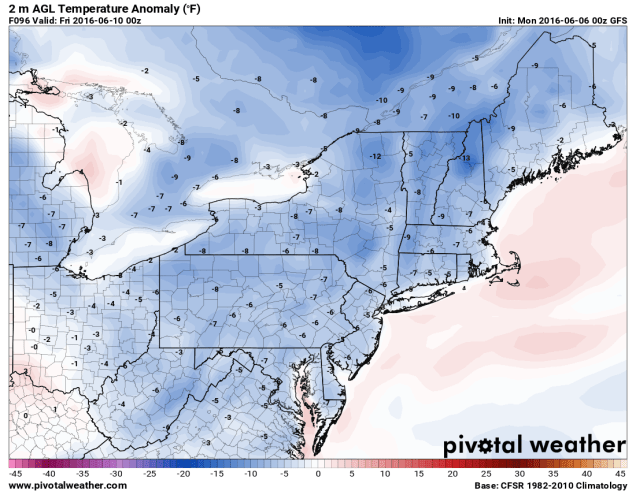
Temperatures on Thursday could be 5-10 degrees below normal across the region based on the GFS model. Image provided by Pivotal Weather.

Monday: Partly to mostly sunny, just a slight chance for an afternoon shower.High 78-85.

Monday night: Clear to partly cloudy. Low 56-63.

Tuesday: A mix of sun and clouds with afternoon showers and thunderstorms developing. High 76-83.

Tuesday night: Becoming clear to partly cloudy. Low 52-59.

Wednesday: Partly sunny, chance for afternoon showers and thunderstorms.High 66-73.

Thursday: Intervals of sunshine and clouds, breezy. High 60-67.

Friday: Partly to mostly sunny.High 63-70.

Saturday: Becoming partly to mostly cloudy, chance for a few showers late. High 67-74.

Sunday:Mostly cloudy with a chance for more showers. High 65-72.
gfs_t2min_boston_19
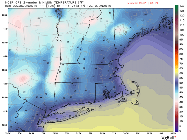
GFS model forecast for low temperatures Friday morning. Turn off the AC and open the windows because it might drop into the 40s across much of the area. Image provided by WeatherBell.

Tropical Storm Colin should pass well south and east of the region later this week, with minimal impacts on our region. It might increase the surf a bit along south-facing coastlines, so grab your wetsuit and board if that’s your thing. Otherwise, you should probably stay out of the water because A) it’s still pretty chilly and 2) it’s not that safe.

Weekly Outlook: May 30 – June 6

We’ve got a little bit of everything in this week’s forecast. Well, OK, not everything, there’s no snow in the forecast, but just about everything else. We start off with a rather wet Memorial Day, thanks to a cold front and the moisture from “Bonnie”.

wpc_total_precip_boston_7
Much of the region will receive around an inch of much-needed rain on Memorial Day. Bad for barbecues, good for lawns. Image provided by WeatherBell

Tuesday, we get back into the sunshine and warm temperatures with high pressure building in. Wednesday looks to be dry as well, but a backdoor cold front may bring another cooldown to coastal areas into Thursday. The end of the week looks a bit unsettled and a little cool for early June, with another cold front slowly moving into the region, giving us a chance for more showers and thunderstorms.

ir_lalo-animated
Seriously, that’s a tropical depression? Loop provided by NOAA.

Monday: Periods of rain, possibly heavy at times, especially during the morning. High 71-78.

Monday night: Showers taper off in the evening, some clearing towards daybreak. Low 58-65.

Tuesday: Becoming partly to mostly sunny, though clouds and a few showers could linger near the South Coast and Cape Cod for a while. High 78-85.

Tuesday night:Clear to partly cloudy. Low 53-60.

Wednesday: Sunshine and a few clouds.High 70-77, turning cooler along the coast in the afternoon.

Thursday: A mix of sun and clouds.High 64-71.

Friday: More clouds than sunshine, chance for an afternoon shower or thunderstorm.High 65-72.

Saturday: Partly sunny, scattered showers and thunderstorms.High 68-75.

Sunday: Intervals of sun and clouds, more showers and thunderstorms possible.High 68-75.

Weekly Outlook – May 23-30

The upcoming week will feature a wide range in temperatures across the region, as is typical of Spring in New England. However, as we approach Memorial Day, the traditional start of Summer, it looks like some summer-like weather will finally settle in. As always though, there is a fly in the ointment – a backdoor cold front.

We’ll start the week with clouds and cool temperatures, thanks to low pressure moving up the East Coast. It will spread the clouds in today, with showers moving in tonight and Tuesday.

wpc_24hr_precip_boston_6
Bring an umbrella if you’re heading out Monday night or leaving for work early Tuesday. Up to half an inch of rain is possible across the area. Image courtesy of WeatherBell

High pressure starts to build in on Wednesday with sunshine and warmer temperatures. Thursday is where things start to get tricky. It should be a warm day with showers and thunderstorms likely in the afternoon as a cold front moves through the region. That front stalls out to our south, so Friday will be likely cooler, especially along the coast, thanks to a wind off the still-cool ocean. The big question is, when does the front head back to the north as a warm front? If it’s late Friday, as some models suggest, then temperatures could spike into the 80s in the afternoon across inland areas while the coast stays cool. If it’s late Saturday, then Friday remains cool in most spots, while Saturday could see the temperatures spike in the after noon. Showers and thunderstorms are likely to accompany the front as well. Regardless of when the front comes through, Sunday and Memorial Day look look to be partly to mostly sunny and quite warm, with temperatures well into the 80s, maybe even low 90s in a few spots. A few showers and thunderstorms may pop up each afternoon, but it looks like the bulk of the activity will stay to the north.

gfs_t2max_boston_33
The GFS is forecasting temperatures near 90 for much of the region on Memorial Day. Image provided by WeatherBell.

Monday: A sunny start, then increasing clouds.High 69-76.

Monday night: Cloudy with showers developing, possibly a rumble of thunder. Low 48-55.

Tuesday: Cloudy with scattered showers and a few thunderstorms. High 60-67.

Tuesday night: Gradually clearing skies. Low 50-57.

Wednesday:A mix of sunshine and clouds. High 77-84.

Thursday: Partly sunny, chance for a few showers and thunderstorms.High 77-84.

Friday: More clouds than sunshine, showers and thunderstorms are possible. High 62-62 along the coast, 70-77 inland.

Saturday: A mix of sun and clouds. High 76-83.

Sunday: Partly sunny, chance for afternoon showers and thunderstorms. High 83-90.

Memorial Day: Partly sunny, afternoon showers and thunderstorms possible again. High 83-90.