Weekly Outlook: December 10-16, 2018

How many of you saw the reports of 1-2 feet of snow in North Carolina and Virginia over the weekend and said to yourself “better there than here”? We don’t have anything like that in our near-future, but that doesn’t mean the week will be snow-free.

MIDATL
Heavy snow fell over the weekend in places that don’t usually get heavy snow, especially in early December. Image provides by the National Weather Service Eastern Region Headquarters

The week starts off with high pressure building in for today and into Tuesday. That means plenty of sunshine and cool temperatures. We may see some clouds and possibly a flurry across the Outer Cape, but otherwise, dry and cold. Tuesday night into Wednesday could be a little interesting though. Low pressure will pass well offshore, but an upper-level disturbance will be moving through at the same time. With cold air in place and north-to-northeast winds blowing over the relatively mild Atlantic, we could see some ocean-effect snow right along the coast. This is the same mechanism that produces lake-effect snow around the Great Lakes. Most of this snow will be confined to coastal areas, especially coastal Maine to Cape Ann, and eastern Plymouth County over to Cape Cod. We’re not expecting much more than a dusting to an inch for these locations, though a few spots, especially on Cape Cod, could see a couple of inches if one of these bands off the ocean stays in place long enough.

ndfd_snow_massachusetts_12
A little bit of snow is possible on Wednesday right along the coast. Image provided by WeatherBell.

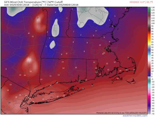
High pressure builds back in on Thursday with another shot of dry and cold air, but it will be short-lived as milder air (and clouds) start to move in on Friday ahead of the next storm system. There’s still a lot of questions with this system, namely where it actually tracks, but it does look to be milder, so we’re probably talking about rain (because we haven’t had enough of that in the last 3 months!) Some models show the potential for heavy rain, others don’t have as much. Some have it getting quite mild on Saturday, while others have it mild, but not that warm. As long as you’re not shoveling it, you probably don’t care that much, right? A second storm likely follows on Sunday, but this one looks like it will remain well to the south, likely too far south to have much, if any, impact on the region, other than to help drag more cold air down from Canada.

GFS 50-STATES USA undefined undefined 144
At least one model shows the potential for a mild day on Saturday, though it could be quite wet. Image provided by Weathermodels.com

Monday: Mostly sunny, except partly sunny across Cape Cod. High 29-36.

Monday night: Clear to partly cloudy. Low 14-21.

Tuesday: Plenty of sunshine, except for Cape Cod once again. High 30-37.

Tuesday night: Clear to partly cloudy. Low 19-26.

Wednesday: More clouds than sunshine, breezy, some light snow or flurries possible along the east coast. High 28-35.

Thursday: Partly to mostly sunny. High 30-37.

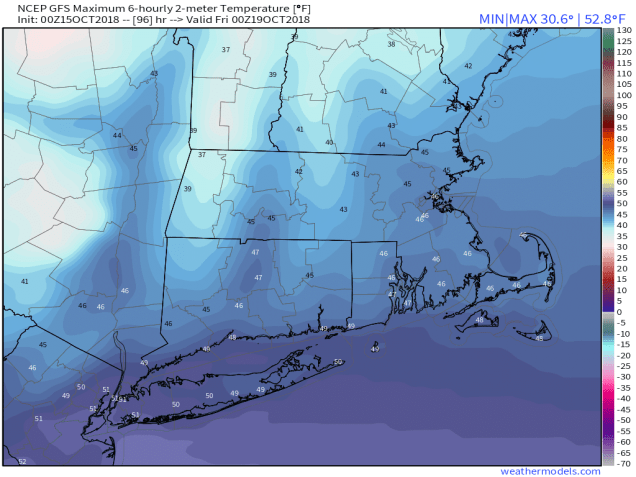
Friday: Increasing clouds and milder. High 41-48.

Saturday: Mostly cloudy and breezy with periods of rain likely. High 45-52.

Sunday: Intervals of clouds and sunshine. High 38-45.

Weekly Update: December 3-9, 2018

We’re into December already, which means that 2018 is nearly over.  Before we officially turn the page, we’ll just let you know that this was one of the wettest Novembers ever across the Northeast and Mid-Atlantic states, and in many locations it was the wettest on record. The same could also be said for meteorological autumn as a whole (defined as the months of September, October, and November.)

November
This was one of the wettest Novembers on record for much of the Northeast and Mid-Atlantic. Image provided by the Northeast Regional Climate Center.


December started off on a wet note, which a system producing an inch or so of rain across the area late Saturday night into Sunday, but much of the upcoming week should be dry. Yes, you can put your umbrella and raincoat away for now. In fact, you won’t even need a heavy jacket today, as it will be quite mild (by December standards). We’ll start the morning off with some patchy dense fog, which may have trouble burning off due to the low December sun angle. However, once it does, we’ll get some sunshine, which may help temperatures climb into the 50s in many areas. The warmth will be short-lived however, as a strong cold front will move through late in the day.

High pressure builds in for Tuesday through Thursday with dry and much colder conditions. We’ll have plenty of wind on Tuesday as well, creating rather chilly wind chills. For Wednesday and Thursday, we’ll need to keep an eye on the potential offshore storm system, but right now it looks like it will stay too far offshore to have any impact here. Another cold front moves through late Thursday, bringing us even more cold air for the end of the week and start of the weekend. Parts of the area may struggle to get into the 30s on Saturday.

GFS 50-STATES USA undefined undefined 126
Heading out Friday night? Bundle up! Wind chills may be in the single numbers and lower teens in the evening. Image provided by Weathermodels.com

After that, things get complicated. For Sunday (and/or next Monday), most of the models have been showing the potential for a coastal storm. The problem is, none of these models have been consistent at all. On some runs, the models show the storm staying well to our south. Sometimes, they’ll show no storm at all. Other times, they’ll show a classic Nor’easter with heavy snow inland and rain along the coast. Other times, they show a storm that buries the South Coast, but has virtually no precipitation at all north of Boston. These models never seem to show the same solution from one run to the next, and they don’t seem to agree with one another either. Given that it’s a week away, this isn’t too much of a surprise. So for now, we’ll just keep an eye on it. If the threat does materialize, we’ll have a special blog post later in the week, once we’re a little more certain about what may or may not happen.

gfs.prateptype_cat.us_ne.trend
This is the last 12 runs (3 days worth) of the GFS model for next Sunday night. Notice how much the forecast varies from one run to the next. Loop provided by Pivotal Weather.

Monday: Morning fog, then becoming partly to mostly sunny and breezy.  High 49-56.

Monday night: Clear to partly cloudy. Low 23-30.

Tuesday: Sunshine and a few clouds., breezy, and colder. High 30-37.

Tuesday night: Clear skies. Low 16-23.

Wednesday: Sunny in the morning, some clouds move in during the afternoon. High 30-37.

Thursday: Intervals of clouds and sunshine, slight chance for a rain or snow shower late in the day and at night. High 34-41.

Friday: Some morning clouds, then becoming partly to mostly sunny and breezy. High 31-38.

Saturday: A mix of sun and clouds. High 26-33.

Sunday: Partly to mostly cloudy and breezy with a chance for snow or rain. High 30-37.

Weekly Outlook: November 26-December 2, 2018

It’s going to rain again. No, we’re not kidding. Mother Nature has apparently decided that we need more rain. A lot of it in fact. Yes, really. So keep your umbrellas handy, you’ll need them more than once this week.  Better than keeping the shovels ready, right?

Autumn
With less than a week to go, the fall has been among the 3 wettest on record for much of southern and southeastern New England. Image provided by the Northeast Regional Climate Center.

We start the week off with, you guessed it – rain. Low pressure will head into the eastern Great Lakes today. This is the same system that produced blizzard conditions from the Rockies across the Plains and into the Chicago area over the weekend. We’ll be on the warm side of it, so we just get rain. A lot of rain, but still, just rain. Unless of course, you’re in the Berkshire, or the Lakes Region of New Hampshire (or maybe interior southern Maine). The heaviest rain is expected from late this afternoon into tonight, just in time to make your Monday afternoon commute even more miserable. We may also have some gusty winds accompanying the rain, especially along the coastline.

hires_tprecip_boston_61
Much of the region may receive another 1-2 inches of rain over the next day or two. Image provided by WeatherBell.

The rain winds down late Monday night, and everything improves on Tuesday, right? Not quite. An upper-level low pressure area will slowly move across the region during Tuesday and Wednesday. This will keep plenty of clouds around, though a few sunny breaks are possible at times. We’ll still have some pop-up showers at times, but since it’ll be turning colder, some of those showers could contain some wet snow.

GFS 50-STATES USA undefined undefined 108
The GFS model is forecasting the region to be cloud-free Friday morning, except possibly on the Outer Cape. Will it actually happen? We’ll find out. Image provided by Weathermodels.com

High pressure finally builds in for Thursday and Friday, which means you can put the umbrellas away for a few days and actually use your sunglasses! That’s right, the sun will return! Oh, it’ll still be chilly, it is the end of November after all. The clouds come back in late Friday as a weak storm system moves toward the area. It’ll give us a few rain or snow showers Friday night into Saturday morning. That system moves out quickly, but another one quickly follows that will be more potent. In fact, it will behave similarly to today’s storm. We’ll have rain moving in for Sunday, possibly heavy. We need more rain, right? Again, would you rather have more rain or snow instead? That’s what we thought. Longer-range models indicate that the stormy pattern will likely continue into next week. Eventually it’ll be cold enough that one of these storms will be snow. Which one? We can’t say for sure at this point, but you know it’s coming at some point.

Monday: Cloudy and becoming breezy with rain developing, possibly heavy in the afternoon. High 40-47.

Monday night: Cloudy and windy with rain likely, possibly heavy in the evening, tapering off overnight. Low 36-43.

Tuesday: More clouds than sunshine, breezy, chance for a shower or two. High 39-46.

Tuesday night: Partly to mostly cloudy. Low 26-33.

Wednesday: Plenty of clouds with some sunny breaks at times, a few rain or snow showers are also possible. High 36-43.

Thursday: Sunshine and a few clouds, breezy. High 38-45.

Friday: Sunny in the morning, clouds start to move in during the afternoon. Some rain or snow showers are possible at night. High 36-43.

Saturday: Mostly cloudy, rain or snow showers ending early, then rain redevelops overnight. High 38-45.

Sunday:  Cloudy with periods of rain. High 43-50, possibly warmer across southeastern Massachusetts and Rhode Island.

Weekly Outlook: November 19-25, 2018

Well, now that we’ve had our first snow of the year, who’s ready for more? Yup, there’s snow on the way for parts of the region. After that, everyone can expect some frozen turkey for Thanksgiving. Let’s get right to the details.

We start the week off with a fairly benign system moving across the region. Any rain or snow showers will end towards midday. The clouds will remain in place as another system will quickly follow. This system will be a little more potent tonight into Tuesday. It will also be a lot more complicated. Precipitation will redevelop around midnight. If you live north and west of 495, the precipitation will likely be in the form of snow. For the rest of us, it’ll start as rain. The precipitation will continue into the morning, then by late morning, the rain/snow line will start to sag southward towards the Boston area. Everything should wind down by early afternoon. Snow accumulations will range from a dusting in the Boston area, to a couple of inches north and west of Boston, to 3-5 inches from the Merrimack Valley into Southern New Hampshire.

nam_3hr_snow_acc_boston_21
The NAM model is closes to our thinking in terms of snowfall om Tuesday. Image provided by WeatherBell.

This brings us to Wednesday. An arctic cold front will cross the region. This front may be accompanied by some snow showers or squalls during the afternoon hours. Behind the front, we’re looking at the coldest air so far this fall for Thanksgiving Day. Low temperatures in the teens, possibly even some single numbers in the cold spots, may set new record lows. If you’re heading out to a high school football game, you’d better bundle up, since wind chills will be in the single numbers or below zero. We’ll have plenty of sunshine during the afternoon, but it won’t help that much, as high temperatures will be stuck in the 20s for most of us. Thursday night will also be quite cold, so keep that in mind if you’re going to wait outside for Black Friday sales.

GFS 50-STATES USA Mass & CT & RI Wind Chill Temperature 84
Bundle up if you’re heading out early Thanksgiving morning. Wind chills will be near or below zero. Image provided by weathermodels.com

Don’t worry, the cold shot will be brief as we’ll see temperatures start to moderate for Friday and Saturday as high pressure slides offshore.  The next storm system moves in for Saturday night and Sunday. Unlike the last couple, this one should be mostly rain. In fact, it might be a lot of rain. But, at least it’ll be rain, not snow, right?

qpf_048h.us_ne
At least one model is forecasting some excessive rainfall next week. Image provided by Pivotal Weather.

Monday: Cloudy with some snow or rain showers during the morning. High 38-45, except 46-53 across southeastern Massachusetts and Rhode Island.

Monday night: Rain redeveloping inside I-495, snow north and west. Low 30-37.

Tuesday: Rain changing to snow, ending late in the day. Accumulations less than 1″ in Metro Boston, 1-3″ north and west of Boston, 2-4″ in the Merrimack Valley and the NH Seacoast, and 3-5″ in southern New Hampshire. High 33-40 early, warmer across southeastern Massachusetts. Temperatures slowly drop during the afternoon.

Tuesday night: Becoming partly cloudy. Low 20-27.

Wednesday: A mix of sun and clouds, becoming breezy. Some snow showers or squalls are possible late in the day. High 33-40.

Thanksgiving: Mostly sunny, breezy, and cold. High 18-25.

Friday: Mostly sunny. High 25-32.

Saturday: Increasing clouds, rain develops at night. High 40-47.

Sunday: Breezy with rain, possibly heavy. High 45-52.

Weekly Outlook: November 12-18, 2018

It’s coming. The day you’ve been dreading for a while. For some of us, that day will happen this week. That’s right, the first snowflakes of the season could occur within the next 7 days.

60dPNormNRCC
Rainfall has been well above normal across the region for a few months now. Of course, we’ve got more on the way! Image provided by the Northeast Regional Climate Center.

The week starts off on a bright but chilly note with high pressure in control. We’ll have some sunshine today, but clouds move in this afternoon as low pressure starts to move towards the region. This system will bring in another shot of rain, possibly heavy on Tuesday, because we haven’t had enough rain yet this fall. The rain may start as some wet snow in parts of central and southern New Hampshire, but for the majority of us, this will be a rain event. The rain will continue for much of the day, tapering off around dinner time, but it’s the evening and overnight hours that we’re actually concerned about.

As the storm pulls away Tuesday night, gusty northwest winds will usher some of the coolest air so far this fall into the region. Temperatures will drop rather quickly Tuesday night, so any roads that are still wet could start to ice up during the evening, mainly from the Merrimack Valley northward. So, if you’re heading out Tuesday evening, be careful and pay a little more attention to the roads you’re on. Skies clear out Tuesday night as high pressure builds in, setting up Wednesday with sunshine along with windy and cold conditions. Winds will diminish late in the day, which means that Wednesday night will be quite chilly with clear skies and light winds setting up a good night for radiational cooling.

GFS 50-STATES USA Mass & CT & RI Wind Chill Temperature 75
Heading out to dinner Wednesday evening? Better find the winter clothes. Wind chills will be in the teens and 20s. Image provided by weathermodels.com.

Thursday will be a lot like today. We’ll start off with sunshine and chilly conditions, but clouds will start to move om ahead of another storm system. While this storm will likely bring another round of locally heavy rain in Thursday night and Friday, it may not be all rain. we’ll be starting off cooler than today. The precipitation may start as snow, even into the Boston area, but a change to rain is expected. Some accumulations are possible before the changeover, especially across southern New Hampshire and possibly the Merrimack Valley. The rain ends on Friday, then high pressure builds in for the weekend with breezy and cold conditions once again. don’t be surprised if a few flurries develop as an upper-level low pressure system crosses the region.

gfs_mslp_pcpn_frzn_neus_fh72-120
You know what the blue color means. Most of you don’t like it. But, it’s getting to be that time of year. Loop provided by Tropical Tidbits.

Monday: Sunny and chilly to start, clouds move in during the afternoon. High 42-49.

Monday night: Becoming cloudy with rain developing after midnight, possibly mixed with some wet snow in southern New Hampshire. Low 35-42.

Tuesday: Rain, heavy at times through early afternoon, tapering off and ending late in the day. Becoming breezy. High 45-52, warmer across southeastern Massachusetts, southern Rhode Island, and Cape Cod.

Tuesday night: Clearing and windy. Low 24-31.

Wednesday: Mostly sunny, windy, and colder. Winds diminish late in the day. High 31-38.

Thursday: Sunny and cold early, clouds move back in during the afternoon. Snow develops at night, changing to rain before daybreak from south to north. High 33-40.

Friday: Rain, possibly heavy at times, ending in the afternoon. High 41-48.

Saturday: A mix of sun and clouds, breezy, chance for a few rain or snow showers. High 40-47.

Sunday: Partly sunny, slight chance for a snow flurry. High 30-37.

Weekly Outlook: November 5-11, 2018

Yup, we’ve got some November Rain in the forecast, so that seemed liked an appropriate intro to this week’s update. We’ve also got Election Day tomorrow, so you know what that means – we’ll finally get regular annoying commercials back on TV Wednesday instead of all of the political ones! Oh yeah, and make sure you get out and vote. Or don’t. It’s your choice. We’re going to stay out of politics here, because this is a weather blog. So, without further delay, let’s get to the forecast.

The week starts off with an area of low pressure passing south of the region. It will give us plenty of clouds today, along with some showers during the afternoon, and maybe some steadier rain at night, but all-in-all, this system isn’t that big of a deal. However, the system right behind it, will have a bit more of an impact. It will move into the Great Lakes Tuesday before heading into southern Canada. It will bring in some steadier and heavier rain on Tuesday, so make sure you elect to bring an umbrella with you that day. It will drag a cold front through late in the day, which will bring an end to the rain. The system will also bring in some milder conditions, at least south of the Mass Pike. We’ll see how far north the warm air actually gets. Some models try to bring it up into southern New Hampshire, others keep it confined to southeastern Massachusetts and Rhode Island. For now, we’re going with the warmth extending into southern New Hampshire, but there is a significant bust potential there – temperatures could end up 5-15 degrees cooler than what we’re currently thinking.

60dPDataNRCC
More rain? Most of the region has received 10-15 inches since Labor Day. We don’t need any more for now! Image provided by the Northeast Regional Climate Center.

High pressure builds in on Wednesday, and it looks like it may remain mild. That won’t last though, as cooler weather moves in on Thursday as the high slides right across the region. By Friday, clouds stream back in ahead of the next system. This one should be a fairly quick-moving one, but it will bring another round of rain in late Friday and Friday, ending early Saturday morning.

GFS 50-STATES USA undefined undefined 150
Heading out Saturday night? Wind chills could be in the 20s to lower 30s. Better find that winter coat you stored away. Maybe some gloves and a hat too. Image provided by Weathermodels.com

High pressure builds in once again next weekend, with another round of cooler conditions. This looks like the coolest airmass yet, as much of the area may stay in the 40s for highs both Saturday and Sunday. Normal highs for mid-November are still in the lower to middle 50s, so while this is cool, it’s not unusual for this time of year.If you’ve been resisting turning your heat on, you may finally lose that battle, as nighttime lows will be mainly in the 20s and 30s. Some clouds may move back in late Sunday as another weak system moves out of the Great Lakes. This may bring in some light precipitation Sunday night into Monday. Notice that we said “precipitation” and not “rain.” That’s because we’re not sure it will be just rain. Whatever falls, it doesn’t look like much at all, but don’t be surprised if we see some flakes around here around that time. There’s also the potential for another storm on Tuesday that may contain more precipitation, and again, may not be entirely liquid. We’ll have more detail on that in next week’s outlook, if things don’t change (which they almost certainly will).

Monday: Cloudy with some showers possible in the afternoon. High 46-53.

Monday night: Cloudy and breezy with showers likely. Temperatures hold steady or rise a few degrees overnight.

Tuesday: Some showers and drizzle early, windy with steadier rain developing in the afternoon. High 57-64, possibly cooler, especially in southern New Hampshire.

Tuesday night: Rain ends in the evening, then skies clear out after midnight, still breezy. Low 44-51.

Wednesday: Sunshine and a few afternoon clouds, breezy again. High 54-61.

Thursday: Mostly sunny and cooler. High 47-54.

Friday: Some early sun, otherwise becoming cloudy with showers developing in the afternoon, becoming a steady rain at night. High 46-53.

Saturday: Showers ending in the morning, then becoming partly to mostly sunny and breezy in the afternoon. High 44-51.

Sunday: A sunny start, then clouds move in during the afternoon. High 38-45.

Weekly Outlook: October 29 – November 4, 2018

We’ll tell you right now – the best day of the week is going to be Wednesday, and not because it’s Halloween. It’s going to be an absolutely glorious day. Why? That’s when the parade is.

As for the weather itself, well, a good chunk of the week should be nice, and believe it or not…..mild! The week starts off on a damp note though, as a little system comes rolling in from the west, giving us some rain showers this morning, ending by early afternoon. We’re not looking at a lot of rain, certainly nothing compared to what we had on Saturday, but it will fall during the morning commute, so, be prepared for that.

hrrr_ref_frzn_neus_fh1-18
It’ll be wet out this morning, so bring an umbrella to work or school. Things will improve this afternoon. Loop provided by Tropical Tidbits.

After that, high pressure builds in with dry and warmer conditions for Tuesday and Wednesday. If you’re heading to the parade on Wednesday, expect plenty of sunshine with temperatures in the 50s. For trick-or-treaters that evening, expect it to be dry abd possibly a little breezy with temperatures generally in the middle to upper 50s. By Thursday, we’ll really start to warm up with temperatures getting into the 60s, but it will come with clouds as a storm system starts to approach the area. That storm passes to our north and west Thursday night into Friday, with some rain likely along with the mild temperatures. A cold front brings an end to the rain and the mild weather late Friday.

GFS 50-STATES USA Mass & CT & RI 2-m Maximum Temperature 96
Despite the cloudcover, Thursday is looking like a very mild day. Image provided by Weathermodels.com

We’ll have a brief break on Friday night, but another system will start to head up the coast early Saturday, with a chilly rain expected for much of Saturday and Saturday night. This system may produce a little bit of snow in the mountains, but we shouldn’t have much to worry about around here. High pressure builds in on Sunday with dry and cooler conditions.

Also, don’t forget, Daylight Saving Time ends Sunday morning at 2am. If you have any clocks that don’t automatically update, then you’ll need to change them back an hour Saturday night. The good news is that you’ll get an extra hour of sleep. It’ll help make up for all the sleep you lost staying up for the Red Sox games.

Victory-Cigar-Congress-Passes-DST
Turn your clocks back an hour Saturday night before bed. We don’t want to know what you’re doing with your hoe for that extra hour. Image provided by Wikipedia.

Monday: Showers ending by early afternoon, some clearing develops late in the day. High 50-57.

Monday night: Clear to partly cloudy. Low 34-41.

Tuesday: A mix of sun and clouds. High 44-51.

Tuesday night: Clear skies. Low 30-37.

Wednesday: Sunshine and a few clouds, becoming breezy. High 55-62.

Thursday: Becoming partly to mostly cloudy and breezy. High 62-69.

Friday: Cloudy and breezy with showers likely. High 59-66.

Saturday: Mostly cloudy with more rain likely. High 50-57.

Sunday: Partly to mostly sunny. High 49-56.

Weekly Outlook: October 22-28, 2018

The forecast for this week is fairly straightforward for most of the work week. Next weekend? Well, there could be some issues.

NWS NDFD 2.5-km Mass & CT & RI 2-m Daily Low T 1
We’re starting the week off on a very chilly note. Image provided by Weathermodels.com

The week starts off on a chilly, but dry note with high pressure in control. If you’re up early enough, you may need to find the scraper for your windshield before you head out. Either that, or turn the defroster on and let in run for a but before you get in the car.Yup, it’s that time of year again. Clouds will start to stream in late in the day as a fast-moving storm system approaches from the Great Lakes. That system will bring us some rain showers on Tuesday. If the rain moves in early enough, we could see some snowflakes mixing in, mainly across the higher terrain from central Massachusetts into southwestern New Hampshire.

hires_snow_neng_61
The storm on Tuesday and Wednesday could drop a decent amount of snow from parts of Northern New England into New Brunswick. Image provided by WeatherBell.

As that system departs, it will start to strengthen as it moves into the Gulf of Maine and Atlantic Canada. It may drop a decent a mount of snow from the mountains of northern New England into parts of northern Maine and New Brunswick, but around here, we can expect breezy and cooler conditions for Wednesday and Thursday. High pressure builds in on Thursday, allowing the winds to die down, with dry and cool conditions continuing into Saturday.

Later Saturday and into Sunday is where things start to get complicated. Hurricane Willa will make landfall in southwestern Mexico on Tuesday, then move into Texas, and then the Gulf of Mexico (but not as a tropical system any more). From there, it will start to head up the East Coast, while becoming a strong storm system once again. High pressure to the north should block in from getting in here on Saturday, though the clouds ahead of the system will move in. It’s Sunday that could be a problem. As the high continues to retreat to the north and east, we’ll still have plenty of cold air in place Saturday night into Sunday. As the storm starts to move up the coast, it will spread some moisture into the region. If you have cold air trapped at the surface while moisture and milder air move in aloft, you have the potential for problems. While coastal areas will just see a gusty winds and a cold rain, across interior areas, we have the potential for some sleet or freezing rain on Sunday. Milder air should eventually win out, with a change to all rain even across the interior. There are other models that have the storm pass to our west, which would just mean a wind-swept mild rain. Obviously, there’s a lot of uncertainty with future of this system. For now, we’re leaning towards the colder scenario, but it’s low confidence. As we get later in the week, if this scenario becomes more likely, we’ll keep you updated.

gfs_mslp_pcpn_frzn_neus_fh120-168
The GFS model is showing the potential for some sleet or freezing rain across the interior next Sunday. Other models have a wind-swept warmer rain. It’s too early to tell which scenario is more likely. Loop provided by Tropical Tidbits.

Monday: Sunny and chilly to start, clouds start to move in during the afternoon. High 45-52.

Monday night: Becoming mostly cloudy, showers developing towards daybreak, possibly mixed with some wet snowflakes across the interior. Low 35-42.

Tuesday: Cloudy with scattered showers. High 45-52 north and west of I-495, 53-60 elsewhere.

Tuesday night: Showers ending in the evening, then some clearing late at night. Low 34-41.

Wednesday: Becoming partly to mostly sunny and breezy. High 46-53.

Thursday: Sunshine and a few clouds, still breezy. High 40-47.

Friday: Partly to mostly sunny. High 41-48.

Saturday: Some early sun, otherwise thickening clouds throughout the day. Breezy again. High 44-51.

Sunday: Cloudy and breezy with rain likely , possibly starting as a period of freezing rain and/or sleet across the interior. High 39-46 north and west of I-495, 47-54 elsewhere.

Weekly Outlook: October 15-21, 2018

Fall has finally arrived, and you’ll know it for sure this week. If you’re playing the game of trying to avoid turning on the heat before November 1, there’s a good chance you’ll lose before this week is out.

snow_2d_mw
The storm moving into our area today brought snowfall to the Rockies and Plains over the weekend. We’re not going to see any snow around here from it. Image provided by Weathermodels.com

We start the week off with low pressure passing well north of our area. This low used to be Hurricane Sergio in the Pacific Ocean. As it moved across the nation’s mid-section, it produced severe weather in the Mississippi Valley and heavy snow from the Rockies into parts of the Plains. Nothing like that is expected here, but it will bring in some milder air today, along with some showers, mainly during the afternoon an evening. A cold front trailing the system pushes through in the evening which produce some heavier showers, maybe even a thunderstorm, and some gusty winds.

nam3km_mslp_pcpn_frzn_neus_fh6-36
Showers are likely during the afternoon today, but some thunderstorms may accompany the actual cold front this evening, as the high-resolution NAM model shows. Loop provided by Tropical Tidbits.

High pressure builds in on Tuesday with sunshine and breezy conditions, but it’ll turn cooler. The high slides offshore on Wednesday, allowing slightly milder air to move back in, but it’ll be short-lived. Another cold front approaches. This one won’t contain a lot of moisture, so only a few showers are expected. Behind it, windy and much cooler conditions are expected on Thursday. In fact, Thursday will likely be the coolest day we’ve had since the end of April, with high temperatures likely staying below 50 across much of the region.

GFS 50-STATES USA Mass & CT & RI 2-m Maximum Temperature 96
Those are the high temperatures Thursday afternoon, not the lows Thursday morning. Image provided by Weathermodels.com

The cool shot doesn’t last long though, as high pressure moves offshore, allowing temperatures to moderate again. However, another cold front moves through on Saturday, bringing some more showers to the region. Once again, the front moves through, and windy and cooler conditions return on Sunday.

Monday: Mostly cloudy and breezy with showers likely, especially during the afternoon. High 59-66.

Monday night: Showers end in the evening, possibly with some thunder, then skies clear out by daybreak. Low 40-47.

Tuesday: Sunshine and a few clouds, breezy. High 50-57.

Tuesday night: Clear to partly cloudy. Low 39-46.

Wednesday: A mix of sun and clouds, breezy, slight chance for a late-day shower. High 53-60.

Thursday: Partly to mostly sunny, breezy, and cooler. High 41-48.

Friday: Sunshine dimmed by afternoon high clouds. High 53-60.

Saturday: Cloudy with some showers possible. High 54-61.

Sunday: A mix of sun and clouds, breezy. High 44-51.

Weekly Outlook: October 8-14, 2018

Much of the week will not feel like October once again, but changes are coming. Enjoy the warm weather we’ll have this week, it might not be back for a while.

NAM-WRF 3-km Mass & CT & RI 2-m Temperature (1)
We’re going to be riding that temperature roller coast again between today and tomorrow. Loop provided by Weathermodels.com

The week starts out on a cool note. A backdoor front crossed the region on Sunday, and high pressure has built in behind it. With the high in control, temperatures will be cool, but with the front stalled out nearby, we’ll still have plenty of clouds along with some showers. The front lifts northward again early Tuesday as a warm front. Tuesday and Wednesday won’t exactly be hazy, hot, and humid, but partly sunny and unseasonably warm will have to suffice. After that, things get interesting.

14L_tracks_latest
The track of Michael will likely take it inland in the Florida panhandle, then back out into the Atlantic, passing south of New England. How much will it impact us? Image provided by Tropical Tidbits

Tropical Storm Michael formed on Sunday and is now moving into the southeastern Gulf of Mexico. Most of the forecast models show the potential for the storm to rapidly intensify before slamming into the Gulf Coast, likely near the Florida Panhandle, on Wednesday. A lot of these models seem a bit too aggressive in their development of Michael, but they are in fairly good agreement on its track. Once inland, it should head northeastward, bringing more heavy rain to the Carolinas (just what they need!), before moving off the Mid-Atlantic coastline and passing south of New England on Friday. At the same time, low pressure moving into southern Canada will drag a strong cold front through the region. These two will combine to bring an end to the warm weather, but also to produce gusty winds and some heavy rain Thursday into Friday. The front brings in some rain on Thursday, then Michael brings in another round on Friday. How heavy the rain on Friday will be is still up in the air, as it depends on the exact track the Michael, or whatever is left of it by then, actually takes. The best chance for heavy rain will be south of the Mass Pike.

9-km ECMWF USA Cities Mass & CT & RI Total Precipitation 156
The potential exists for some heavy rainfall later this week. Image provided by Weathermodels.com

On Thursday, we may have another wrinkle to throw in – another backdoor front. Some of the models are showing the potential for a backdoor front moving down from Maine Wednesday night, bringing some cooler air into Maine, New Hampshire, and at least northeastern Massachusetts before the front stalls out, and then lifts northward again in the afternoon, before the strong cold front arrives from the west. Other models show Thursday remaining quite mild until the front arrives in the afternoon. We’re going to lean towards the cooler side for now, but keep in mind that it could end up being several degrees warmer than our forecast shows.

Behind the cold front and what’s left of Michael, much cooler weather will move into the region next weekend. How cool? Many of the models show the potential for some wet snow across parts of northern New England, especially in the mountains. One model shows the cold air moving in well before the moisture arrives, with some heavy snow in parts of Maine, extending into the mountains of New Hampshire, but we’re not buying that solution as of yet. As for this area, no snow, but it’ll definitely by cooler with partial sunshine as high pressure tries to build in.

gfs_t2min_boston_27
Harvest what’s left in the garden and put another blanket on the bed – it’s going to be chilly next weekend. Image provided by WeatherBell.


Meanwhile, what about the weather in the Bronx this evening for the pivotal Game 3 between the Sox and Yankees? Well, it’ll likely be cloudy, with a light east wind, which is blowing in from center. A shower is possible, but it shouldn’t interrupt the game. Temperatures will likely be in the middle 60s. For Game 4 on Tuesday, we’re expecting partly to mostly cloudy skies, a light southwest wind (blowing out to left), and temperatures starting in the middle 70s, dropping into the upper 60s by the end of the game. If a Game 5 is needed, it’s scheduled for 7:40pm on Thursday at Fenway. Right now, that forecast looks like rain, southwest winds 5-10 mph (blowing out to center), and temperatures around 70. A delay until Friday would likely be needed, and even that wouldn’t be a sure thing.

5bb89d294fdbc.image
The greatest rivalry in baseball continues tonight and tomorrow in New York. Image provided by Western Mass News.

RedSoxLogoBruinsLogoMonday: Plenty of clouds, chance for a shower or two. High 57-64.

Monday night: Mostly cloudy. Low 51-58 in the evening, then temperatures hold steady or slowly rise a bit overnight.

RedSoxLogoTuesday: Becoming partly sunny, breezy, and warmer. High 71-78.

Tuesday night: Partly to mostly cloudy with some patchy fog developing. Low 60-67.

Wednesday: A mix of sun and clouds, breezy. High 76-83.

RedSoxLogoBruinsLogoThursday: Cloudy and breezy with showers developing, becoming a steady rain at night. High 68-75.

Friday: Mostly cloudy and cooler, with a chance for more rain, possibly heavy, especially south of the Mass Pike and mainly during the morning. High 59-66.

BruinsLogoSaturday: More clouds than sunshine, windy. High 49-56.

PatriotsLogoSunday: A mix of sun and clouds. High 53-60.