Much of the week will not feel like October once again, but changes are coming. Enjoy the warm weather we’ll have this week, it might not be back for a while.
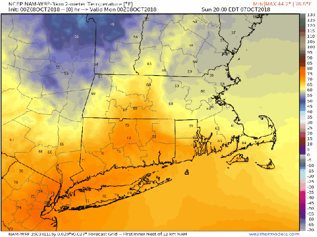
The week starts out on a cool note. A backdoor front crossed the region on Sunday, and high pressure has built in behind it. With the high in control, temperatures will be cool, but with the front stalled out nearby, we’ll still have plenty of clouds along with some showers. The front lifts northward again early Tuesday as a warm front. Tuesday and Wednesday won’t exactly be hazy, hot, and humid, but partly sunny and unseasonably warm will have to suffice. After that, things get interesting.
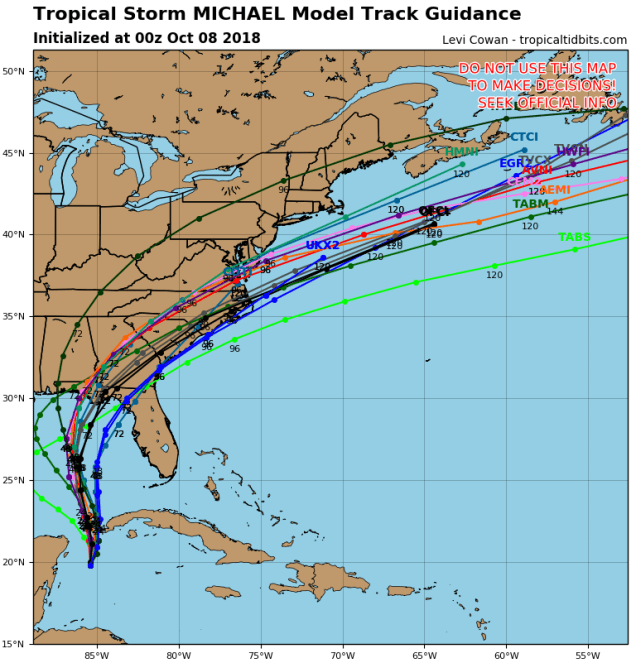
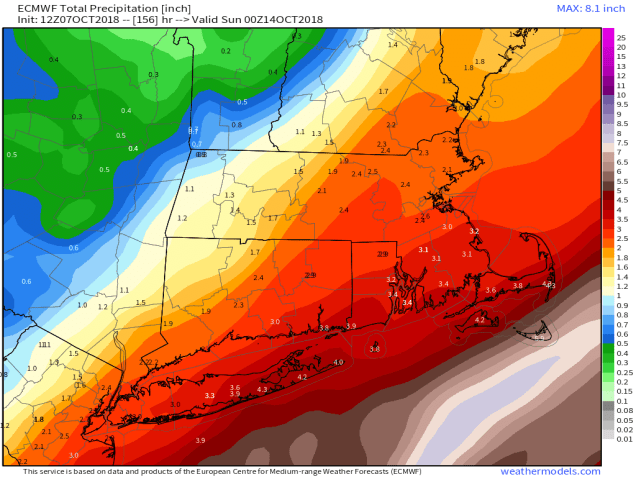
Tropical Storm Michael formed on Sunday and is now moving into the southeastern Gulf of Mexico. Most of the forecast models show the potential for the storm to rapidly intensify before slamming into the Gulf Coast, likely near the Florida Panhandle, on Wednesday. A lot of these models seem a bit too aggressive in their development of Michael, but they are in fairly good agreement on its track. Once inland, it should head northeastward, bringing more heavy rain to the Carolinas (just what they need!), before moving off the Mid-Atlantic coastline and passing south of New England on Friday. At the same time, low pressure moving into southern Canada will drag a strong cold front through the region. These two will combine to bring an end to the warm weather, but also to produce gusty winds and some heavy rain Thursday into Friday. The front brings in some rain on Thursday, then Michael brings in another round on Friday. How heavy the rain on Friday will be is still up in the air, as it depends on the exact track the Michael, or whatever is left of it by then, actually takes. The best chance for heavy rain will be south of the Mass Pike.
On Thursday, we may have another wrinkle to throw in – another backdoor front. Some of the models are showing the potential for a backdoor front moving down from Maine Wednesday night, bringing some cooler air into Maine, New Hampshire, and at least northeastern Massachusetts before the front stalls out, and then lifts northward again in the afternoon, before the strong cold front arrives from the west. Other models show Thursday remaining quite mild until the front arrives in the afternoon. We’re going to lean towards the cooler side for now, but keep in mind that it could end up being several degrees warmer than our forecast shows.
Behind the cold front and what’s left of Michael, much cooler weather will move into the region next weekend. How cool? Many of the models show the potential for some wet snow across parts of northern New England, especially in the mountains. One model shows the cold air moving in well before the moisture arrives, with some heavy snow in parts of Maine, extending into the mountains of New Hampshire, but we’re not buying that solution as of yet. As for this area, no snow, but it’ll definitely by cooler with partial sunshine as high pressure tries to build in.

Meanwhile, what about the weather in the Bronx this evening for the pivotal Game 3 between the Sox and Yankees? Well, it’ll likely be cloudy, with a light east wind, which is blowing in from center. A shower is possible, but it shouldn’t interrupt the game. Temperatures will likely be in the middle 60s. For Game 4 on Tuesday, we’re expecting partly to mostly cloudy skies, a light southwest wind (blowing out to left), and temperatures starting in the middle 70s, dropping into the upper 60s by the end of the game. If a Game 5 is needed, it’s scheduled for 7:40pm on Thursday at Fenway. Right now, that forecast looks like rain, southwest winds 5-10 mph (blowing out to center), and temperatures around 70. A delay until Friday would likely be needed, and even that wouldn’t be a sure thing.

![]()
![]() Monday: Plenty of clouds, chance for a shower or two. High 57-64.
Monday: Plenty of clouds, chance for a shower or two. High 57-64.
Monday night: Mostly cloudy. Low 51-58 in the evening, then temperatures hold steady or slowly rise a bit overnight.
![]() Tuesday: Becoming partly sunny, breezy, and warmer. High 71-78.
Tuesday: Becoming partly sunny, breezy, and warmer. High 71-78.
Tuesday night: Partly to mostly cloudy with some patchy fog developing. Low 60-67.
Wednesday: A mix of sun and clouds, breezy. High 76-83.
![]()
![]() Thursday: Cloudy and breezy with showers developing, becoming a steady rain at night. High 68-75.
Thursday: Cloudy and breezy with showers developing, becoming a steady rain at night. High 68-75.
Friday: Mostly cloudy and cooler, with a chance for more rain, possibly heavy, especially south of the Mass Pike and mainly during the morning. High 59-66.
![]() Saturday: More clouds than sunshine, windy. High 49-56.
Saturday: More clouds than sunshine, windy. High 49-56.
![]() Sunday: A mix of sun and clouds. High 53-60.
Sunday: A mix of sun and clouds. High 53-60.
